
Paul E. Fallon's Blog, page 67
August 12, 2015
Trip Log – Day 98 – Helena MT to Ovanda MT
 August 11, 2015 – Sun 90 degrees
Miles Today: 78
Miles to Date: 5,577
States to Date: 21
I rolled out of Helena by 8:30 a.m. for my climb over the Continental Divide – for my fifth time! Riding conditions were excellent, so MacDonald Pass, at 6200 feet, was not nearly so difficult as other assaults across the Divide. Still, the 3,000 feet rise over 16 miles was a good workout.
 On the downside I stopped for two guys hunched over the open hood of their semi. They were Beevis and Butthead characters with goofy grins, one was tall and skinny, the other squat and fat. The short guy stood with a blown hose in his hands apparently baffled at what to do. I offered a bicycle tube to squeeze over the hole, but he declined. Further on, while on a cold drink break, they eased their massive truck into the station and filled the radiator with gallons of water. I headed north on Montana 141 so never saw them again, but I imagine they didn’t get as far as I did.


Highway 141 is a gorgeous road through a huge valley. Parts are lush with farms, other sections dramatically barren. At 52 miles I found a rare patch of shade along an unnamed reservoir and took a writing break. An empty pickup tied to a boat stood in the pull-off. As I was getting ready to leave, another pickup pulled in. Turns out a couple just starting their vacation broke down, returned to Helena, and borrowed another pickup. They transferred all their stuff, including the boat, to their new ride while waiting for the tow truck from Helena to retrieve the broken vehicle. They were remarkably cheerful given their difficult start. Ten miles later, they gave me a happy honk, beginning their vacation in a borrowed pickup. I was reminded how easy it is for me if Surly needs attention. She fits easy into any Samaritan’s vehicle.
The remainder of the ride was pleasant, though the scent of dead skunk and charred timber polluted the fresh mountain air. Smoke from active fires rose in the distance.
 Ovando is the most unique town I’ve stayed in during my journey: population 75; one roadside restaurant; and a collection of eclectic shops at an irregular square that used to be the center of town. An enterprising woman has converted a sheep wagon, a tipi and the old jail into cyclist sleeping digs for $5 per night. I decided to enjoy a full dinner before turning into a nomad shepherd.
 Trixi’s is a long, narrow building whose fake wood paneled walls are covered with real elk and moose heads. There are ten seats at the bar, eight slot machines, six tables, three video arcade games, a foosball table and one pool table. The waitress, Ovando born and bred, chatted me up as she shuffled three tables together. This region suffered a dry winter and spring, so the summer fires are severe. An extended family was evacuated from the blaze I saw, and was coming in for dinner. Turned out to be the woman who arranged my lodging; we met like old acquaintances. She and her family were in party spirits; confident the fire wasn’t a serious danger.
The world is immense, full of glories and dangers. Our machines fail us, our climate turns forests to tinder, but each mishap creates opportunities to meet interesting people.


Trip Log – Day 97 – Helena MT
 August 10, 2015 – Sun 90 degrees
Miles Today: 15
Miles to Date: 5,499
States to Date: 21
Helena is a delightful town; I had a perfect rest day here. I started with an early morning spin through town – checked out Last Chance Gulch, downtown and the capital. I was fascinated by how the Helena’s founding purpose – gold discovered in Last Chance Gulch, shaped the capital into an unusual urban form. Unlike agricultural communities, which dwell in valleys, or railroad towns, which are linear, everything in Helena presses up against the north face of Mount Helena. The ‘center’ or town isn’t in the center at all; it is at the far south end of a community that continues o to grow north. The original, irregular, grid, which represents development from 1864 until after World War II is full of interesting architecture, significant Victorian mansions, lovely bungalows, and lots of shade trees. The sprawl is limited to the north and east, which makes it less dominating.


After a filling lunch of pizza buffet, I met with Krys Holmes, Executive Director of the Myrna Loy Center. She connected me with Edwin Bender of followthemoney.org and Tim Holmes, a renowned artist who’s embarked on a project of giving his drawings away to random strangers as a means to spur connection.
 It was after six by the time I pedaled out to my warmshowers host. Dawn Bridges is a phenomenal host. She and her husband Scott gave me a room with a view of the western valley, a private bath with a view of Helena climbing the hill, laundry, a great meal that included fresh garden vegetables, and terrific conversation. We didn’t rise from the table until after eleven.


August 9, 2015
Trip Log – Day 95 – Livingston, MT to Bozeman, MT
 August 8, 2015 – Rain, 65 degrees
Miles Today: 30
Miles to Date: 5,382
States to Date: 21
Today was short on miles and long on mental conundrums. Yesterday afternoon I was in downtown Livingston on a sunny afternoon enjoying the vibe of skinny young people serving up local food, creating art, and taping Bernie Saunders posters in storefront windows. This morning I pedaled to the truck stop on the outskirts of town for breakfast before climbing Bozeman Pass. I settled into a platter of giant pancakes, crispy bacon and sunny side eggs; a fly on the wall with big ears. All around me heavyset guys in big hats and booming voices complained and slandered with discomforting assurance. “Who elects these fools in Washington?” “Hillary is a crook, she should be in jail, not the White House.” “Obama hates Jews, at least he does one thing right.” “The Japs are about to invade Australia.” “My gun license prohibits buying guns out of state. Why the hell is that?”

For the first time on my trip, I shied away from joining a conversation and asking my question. The two loudest old men eventually shuffled out to a vintage Lincoln and sped down the highway. I engaged with two women who came in later, personable even as they said Obama is the antichrist and we are entering the end of times. For them, every sign that people of the world are coming together is proof that the end is upon us.
For 23 miles in the rain my legs pumped as my mind wondered how to make sense of my truck stop experience. I want to find reason and value in every person I meet, but I just don’t understand people who thrive in obstinacy and faultfinding.
 The rain cleared. Bozeman was celebrating its Sweet Peas Festival. Hundreds of people lined Main Street for the parade and then trekked to the parks to see art, hear music and eat international food. It was exactly as the truck stop patrons predicted: the world coming together. Yet it seemed less like the end of times than very good times. I took a break in Bozeman’s gorgeous new library, a place to come together if ever there was one. The building has large windows that overlooked the park and festival. The world is so much more positive than my breakfast companions allow.


I don’t want to dismiss people whose primary occupation is maligning and complaining, but since they never offer solutions, I can’t figure out what they want. I almost hope they find satisfaction naysaying; otherwise they’d be mighty unhappy. Regardless, common ground is difficult to find.
I have been in two Montana cities that strike an interesting mix of tradition and progress. In between I found an isolated truck stop where people cock sure of everything wrong congregate. I like to think they will be welcome back to the center of things if they ever realize that living together in peace is something we should embrace rather than fear.


August 8, 2015
Trip Log – Day 94 – Gardiner, MT to Livingston, MT
 August 7, 2015 – Sun, 80 degrees
Miles Today: 57
Miles to Date: 5,352
States to Date: 21
 Today was a dream cycle touring day. I woke without an alarm, enjoyed eggs and English muffins with my warmshowers host, and stopped by the Gardiner Market for a few supplies. So many of my Boston friends have been commenting on the hot, humid weather back home, I couldn’t help but document the perfect morning temperature here.
Fifty-five miles along the Yellowstone River to Livingston. The first twenty miles on US 89 descended a meandering canyon. I really loved the vertical rock formations on Devil’s Slide. The next thirty miles followed East River Road, a lightly travelled byway through aptly named Paradise Valley. Throughout the valley, the particular yellow that gives the region its name shows through on the bluffs. The two roads joined for the final descent into Livingston.


 After navigating the usual ugliness where US 89 meets I-90, I cycled north to downtown Livingston, a hip little city with lots of galleries, coffee shops and boutiques. I wonder who frequents these places, but they all seem to thrive. I had an exquisite lunch at Chadz, topped off by a cinnamon bun at the Bodega Bakery. Downtown goes on siesta about three, so I took at writing break at the library; a classic Carnegie building with a truly pleasant addition.
I pedaled to the outside of town to my warmshowers host. We had a bit of miscommunication, and Eric only offered camping Thankfully the night was beautiful and his yard lush. My second night of sleeping outdoors was terrific.


August 7, 2015
Trip Log – Day 93 – Yellowstone National Park to Gardiner, MT
 August 6, 2015 – Sun and clouds, 70 degrees
Miles Today: 111
Miles to Date: 5,295
States to Date: 21
I saw more of Yellowstone than I anticipated, which turned out to be good thing. I planned to leave my campsite at Grant Village and take the west side of the Grand Loop, to see Old Faithful and then head north on US 89 past most of the geysers to Gardiner, MT. However, a ranger told me there was 17 miles of construction, i.e. gravel, north of Norris. So I revised my 76-mile route into 110 miles by taking in Old Faithful and then looping back to Yellowstone Canyon, up and over Mount Washburn, past Tower Falls and back through the northern tier of the park to get to Gardiner. I began at break of day and spent thirteen hours pedaling, stopping at vistas, and talking to folks.

The requisite picture of Old Faithful
 I was intrigued by how many people were glued to their lens throughout the entire event. A worker in the Park told me that selfie-stacks are the most popular sales item.

The steam glistens off the smooth earth in the morning light.

Nearly twenty years after the 1988 fires, new longpole pines are growing through the fire debris.

Gibbon Meadow is a beautiful stretch of mountain scenery.


Gibbon falls are spectacular. I met Michael Joseph Oswald, author of Your Guide to the National Parks. His camera would probably not even fit in my panniers: his books must have terrific photos.


I was in the Canyon area at lunchtime, the only time I experienced the impact of over three million summer visitors to the park. The canyon is incredible, the chaos of people, traffic, and animal gawking a lot less inspiring.

Everything calmed down as I climbed up Mount Washburn.

This outcropping that towers over the road blew me away.


The northern portion of the park is the least spectacular, yet I found it very satisfying in the early evening light, and Undine Falls was a treat to close my Yellowstone day.


August 6, 2015
Trip Log – Day 92 – Jackson, WY to Yellowstone National Park
August 5, 2015 – Overcast, 70 degrees
Miles Today: 79
Miles to Date: 5,185
States to Date: 20

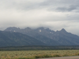
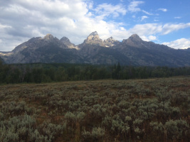
The Grand Tetons are magic! I pedaled in their shadow for over thirty miles, and was mesmerized by their dynamic angles, immense scale, and the play of light and shadow. I woke to light rain and a grey forecast but pushed out for the long ride up to Yellowstone. The first twenty miles followed a new bike path out of Jackson, into Grand Teton Park, all the way to South Jenny Lake. The rain never turned serious. As I rode, the Tetons morphed from looming shadows to stark relief.
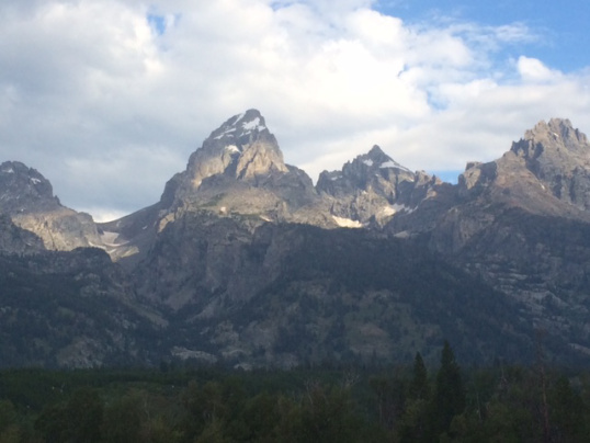
After breakfast at the South Jenny camp area I had thirty solid miles along the Teton Range. The glacier at Mount Morain is impressive, though dwindling. The highway curves around Lake Jackson, which offers spectacular views of Morain from many angles.

I stopped for lunch and enjoyed great bacon mac’n’cheese at a restaurant along the five-mile stretch between Teton and Yellowstone Parks. Refueled, I headed into a national park I have long dreamed of visiting.
The southern portion of Yellowstone is the Teton’s figure-ground cousin. The Tetons splendor is easy to see: the roads in the wide valley are generous; the mountains rise like knives out of the plain. In Yellowstone, the view from the road reveals only millions of longpole pine trees. But as the road cants up, giant crevices and deep canyons fall off on either side. You have to stop at intermittent turnoffs to appreciate them. Riding along the base of the Tetons filled me with awe at the giant sculptural forms. Pedaling along the narrow Yellowstone Road with no shoulder and big drop-offs triggered my vertigo, though I enjoyed many scenic pit stops along the way.


When I stopped at the Continental Divide the sky behind me was black, lightning raging. I cycled four miles downhill to the Grant Village Visitor Center, and arrived at 4:30 p.m. By the time the rain caught up with me, I was safe inside. I stayed there until 7 o’clock closing, during which time I met Laura, a lovely French woman who works in San Francisco and loves to travel the West. She invited me to diner with her boyfriend, Olivier, and we had a lovely meal. Afterward we all attended an informative, funny ranger program on bears. By ten the rain had stopped the stars were bright, and I spent my first night sleeping outside. (FYI: reservations for any accommodation at Yellowstone have to made months in advance, which is not my style. However, they provide same day tents sites for hikers and cyclists. Isn’t that great!)


August 5, 2015
Trip Log – Day 91 – Driggs, WY to Jackson, WY
 August 4, 2015 – Clouds and sun, 80 degrees
Miles Today: 34
Miles to Date: 5,106
States to Date: 20
A short day of intense riding. Eight miles along an easy bike path and then fortified myself with a huckleberry shake in Victor, ID.


Eight miles at 6% grade plus three miles at 10% grade to climb Teton Pass. Met couples from LA, MS and CA at the Wyoming sign. Am I going backwards? I’ve already been in Wyoming! No worry, Jackson Hole beckons.


The descent is more hair-raising than the climb – brakes full throttle for four miles along the old road turned into bike path: too many switchbacks to count.
Arrived in Jackson by two. What am I doing here? A tourist mecca flooded with Asians and guys with big guts all wearing Jackson Hole T-shirts. Don’t they already know where they are? However, the antler arches in the main square are great and it’s cool how the mountains form the backdrop to absolutely everything.


My warmshowers host is a long time Jackson summer resident and bit eccentric. Hooray!
Off to Yellowstone tomorrow – my first night of sleeping outside and no Internet. Goodbye civilization as I know it.


August 4, 2015
Trip Log – Day 90 – Idaho Falls, ID to Driggs, ID
 August 3, 2015 – Overcast and rain, 75 degrees
Miles Today: 79
Miles to Date: 5,072
States to Date: 20

 Everything about today was super-scaled, which left me feeling a bit small and overwhelmed. It started at WinCo, a new grocery chain to me where I stopped to pick up breakfast. It’s Costco meets Safeway: I watched people load cartons of milk and pop and dozens of bags of groceries into the back of their pickups at 7 a.m. while I ate my yogurt and drank a Powerade.

 I had a nice 35-mile ride through farmlands and towns. Eastern Idaho is much more populated than I expected, cultivation like Minnesota at the immense scale of the Dakota’s. In Rexford, a squeaky-clean Mormon town, I stopped at Walgreen’s. When I gave the fresh-scrubbed counter boy my card and asked him about tomorrow, he said, “We’ve been following you!” Turns out he’s an exercise physiology student at BYU-Idaho and his professor used my blog s a case study. How cool is that!
Today may be the only day of my trip that took me in all four directions as I skirted west and north before Highway 33 turns east and finally south into the Teton Valley. Potato fields undulated deep green, wheat shimmered in the breeze, the distant hills were spotted with fir trees, and in the far distance the Grand Tetons, seventy miles away, dominated the horizon. Despite the overcast skies they were a mighty force.
 I detoured to visit the site of the Teton Dam disaster; a tremendous pile of dirt still stands almost forty years after the 280 foot deep dam broke in 1976 and devastated the nearby towns. The Teton River snakes along a narrow path at the bottom. It looks so benign yet countered man’s attempts to tame it.
By the time I reached Tetonia the sky turned from grey to dark. Three miles outside of Driggs the rain began to fall. Within a mile I was drenched. There was no place for cover, so I just kept coming on until I reached The Pines, a really pleasant guest house in town. I was a dirty, wet, tired creature. After getting clean and dry I walked to the fancy supermarket across the street and got delicious ribs, salad, and watermelon for dinner, with cookies for dessert. I climbed into bed by nine.


Trip Log – Day 90 – Idaho Falls, ID to Driggs, ID
August 3, 2015 – Overcast and rain, 75 degrees
Miles Today: 79
Miles to Date: 5,072
States to Date: 20
Everything about today was super-scaled, which left me feeling a bit small and overwhelmed. It started at WinCo, a new grocery chain to me where I stopped to pick up breakfast. It’s Costco meets Safeway: I watched people load cartons of milk and pop and dozens of bags of groceries into the back of their pickups at 7 a.m. while I ate my yogurt and drank a Powerade.
I had a nice 35-mile ride through farmlands and towns. Eastern Idaho is much more populated than I expected, cultivation like Minnesota at the immense scale of the Dakota’s. In Rexford, a squeaky-clean Mormon town, I stopped at Walgreen’s. When I gave the fresh-scrubbed counter boy my card and asked him about tomorrow, he said, “We’ve been following you!” Turns out he’s an exercise physiology student at BYU-Idaho and his professor used my blog s a case study. How cool is that!
Today may be the only day of my trip that took me in all four directions as I skirted west and north before Highway 33 turns east and finally south into the Teton Valley. Potato fields undulated deep green, wheat shimmered in the breeze, the distant hills were spotted with fir trees, and in the far distance the Grand Tetons, seventy miles away, dominated the horizon. Despite the overcast skies they were a mighty force.
I detoured to visit the site of the Teton Dam disaster; a tremendous pile of dirt still stands almost forty years after the 280 foot deep dam broke in 1976 and devastated the nearby towns. The Teton River snakes along a narrow path at the bottom. It looks so benign yet countered man’s attempts to tame it.
By the time I reached Tetonia the sky turned from grey to dark. Three miles outside of Driggs the rain began to fall. Within a mile I was drenched. There was no place for cover, so I just kept coming on until I reached The Pines, a really pleasant guest house in town. I was a dirty, wet, tired creature. After getting clean and dry I walked to the fancy supermarket across the street and got delicious ribs, salad, and watermelon for dinner, with cookies for dessert. I climbed into bed by nine.


August 3, 2015
Trip Log – Day 89 – Pocatello, ID to Idaho Falls, ID
 August 2, 2015 – Sunny, 100 degrees
Miles Today: 60
Miles to Date: 4,993
States to Date: 20
Sunday in the summertime and the living is easy. I got up to the smell of good coffee and enjoyed a breakfast of homemade oatmeal with all sorts of mix-ins on the patio with my warmshowers hosts. I reluctantly took leave after eight, knowing that I wanted to ride in the cool morning rather than the hot afternoon.
 Pocatello is a railroad town; the bridges over the tracks are more spectacular than the roads that span the concrete-lined Portneuf River. I wove north and east to Hiline Road, a great route out of town through big pastures. Hiline connected back to US 91 at Fort Hall, the Shoshone-Bannock Indian Reservation where preparations were underway for their annual festival next week. The road is poker straight past the Indian casino into Blackfoot, one of the poorest towns I have traversed.
Beyond Blackfoot the Snake River Valley is a wide flat plain crisscrossed by an elaborate canal system. Monster irrigation systems snake across green fields, tall rows of trees shelter houses from the wind. Where the sprinklers came near the road, an underdraft of cool air broke the mounting heat. By ten it was near eighty degrees, by eleven it was over ninety. A few feet beyond the sprinklers reach the grass is tawny and dry. The heavy rains of Colorado are long past; the fire monitor gauges all read ‘Danger Very High’, and it’s easy to see how one match would enflame these brittle fields.


I stopped in Firth for a liquid lunch: two yogurts and a Little Debbie cake chased down with a quart of chocolate milk; the perfect protein-infused refresher to push me into Idaho Falls before 2:00 p.m. After a writing break I visited the falls, which as more elaborate than I anticipated. The Snake River is a broad stretch of water, until it tumbles over rocks for several blocks near downtown. My host for this evening Sam, is more a couch surfer than a warmshowers guy. He gave me great tips to connect with folks that way on the road. He headed out to his favorite burger joint, but much is closed in Mormon-centric Idaho Falls on a Sunday night. So we wound up at a roadside diner. The food was adequate; the coconut cream pie dessert was extraordinary.


