
Andrew Skurka's Blog, page 6
November 21, 2023
Released: 2024 guided trip schedule
Our 2024 trip schedule has been released! To view it, click here.
The season will start again in mid-April in Escalante, Utah, which greets us with mild temps, wildflowers, and long days. In addition to our normal Adventure 5-day and 7-day trips, we’ll offer 5- and 7-day technical canyoneering expeditions and one 11-day thru-hike of the Escalante River, from town to Coyote Gulch (or thereabouts) often following Steve Allen’s Overland Route.
Our season resumes in mid-June in Alaska’s Brooks Range. If our timing is good, the rivers will have come down and the snow will be mostly gone, but the mosquitoes will not have hatched yet. The 7-day trips will be in Gates of the Arctic National Park, the ends of which I’ve still not yet found. My goal is to put the 11-day trips in the Arctic Refuge, a new location to the east that is eight times bigger than Yellowstone.
The next stop is the High Sierra, rightfully our most popular location. The mountains are stunning, the weather is almost always perfect, and the off-trail travel is world-class. We will have 3-, 5-, and 7-day trips, plus one 11-day thru-hike of the Yosemite High Route, starting at Sonora Pass and finishing at Tuolumne Meadows.
We take off the month of August for our own summer vacations and my eleventh wedding anniversary.
The crowds thin after Labor Day, so we head back out. For two consecutive years we’ve gone to Olympic National Park, and we may do that again. But I may relocate our operations to Greater Yellowstone, including the park and/or the surrounding mountains, pending the availability of commercial permits. In the Olympics, we would have 5- and 7-day loop trips, and one 11-day traverse of the park, from the northwest corner to the southwest corner. In Greater Yellowstone, we’d offer the same, plus perhaps some 3-day intro-level courses.
It’s become customary that our season ends in West Virginia, with falling fall colors, increasingly longer nights, and crisp daytime high temperatures. This location is ideal for 3- and 5-day trips. We may add half-day caves to one of the longer trips as a pilot program, pending landowners permissions.
Have questions about the 2024 season?Sign up for a one-on-one office hours appointment with Katie or meJoin an Ask Us Anything event, November 28-30Contact me, and I will respond to you promptlyThe post Released: 2024 guided trip schedule appeared first on Andrew Skurka.


November 20, 2023
Let’s chat: Office Hours + Ask Us Anything
In fall 2021 and fall 2022 my guide team offered free one-on-one “office hours” appointments to discuss all things backpacking. They were wildly popular: we hosted 320 calls over the two years, which amounted to nearly 107 hours of time!
Katie Gerber and I will be running this program again next week. The details:
1. Office hours to discuss 2024 guided tripsMonday, November 27 through Friday, December 115-minute blocksThese 15-minute one-on-one appointments are limited to those who are interested in a 2024 trip. We can discuss suitable locations and trip types, our fitness and experience requirements, and any personal unique circumstances (e.g. your group, meal restrictions, allergies).
Book an appointment with Katie (11:00am, 11:20am, and 11:40am daily, Mountain Time)Book an appointment with me (3:00pm, 3:20pm, and 3:40pm daily, Mountain Time)If you are unavailable for any of these times, contact me with your availability and questions so that I can either schedule a one-off meeting or provide you with answers.
Please do not schedule one of these appointments unless you are serious about a 2024 trip. And beforehand please review the website for basic information; it will be updated this week and next with 2024 details. Thank you.
2. Ask Us AnythingKatie and I will host three public “Ask Us Anything” events, each lasting 60 minutes. We’ll start at a different time each night, hoping to catch people on different time zones and with different schedules.
Tuesday, November 28, 6pm Eastern Time (join now)Wednesday, November 29, 6pm Mountain Time (join now)Thursday, November 30, 6pm Pacific Time (join now)Each night we will have a different special guest, details below!
We can discuss topics like:
Locations,Permitting,Likely conditions,Fitness,Gear selection,Holiday gift-giving,Meal planning,Skills,Women-specific considerations,And our guided trips, if you didn’t or couldn’t schedule a one-on-one appointment.3. Question boxIf you would like to submit a question for the Ask Us Anything events, complete this form. During the broadcasts we try to answer all questions received.
Our special guestsTuesday, November 29 — TBA
Flyin’ Brian Robinson — Wednesday, November 28
First person to complete the Calendar Triple Crown, in 2001Barkley Marathon finisher (#7) and former course record holderCompleted the John Muir Trail in 4 days and 7 hoursMikaela Osler — Thursday, November 29
Triple Crown thru-hiker (AT, PCT, CDT)Set FKT’s on the Long Trail and Colorado TrailThe post Let’s chat: Office Hours + Ask Us Anything appeared first on Andrew Skurka.
November 8, 2023
Dinner Recipe: Mushroom and Bacon Oat-sotto
This dinner recipe is flavorful and filling, making it ideal for long days and late in a trip, when appetites are big.
Meal statsRecommended serving weight: 5.7 ozTotal calories: 466Caloric density: 82 cal/ozThose wanting more calories or a higher caloric density should increase the quantity of olive oil, Parmesan, or cashews.
 Ingredients
Several of the ingredients, like oats, cashews, and Parmesan are found in most grocery stores, while others like dehydrated mushrooms, peas, and lemon powder are most easily found online. They add vital flavor however, so don’t skip them. To get the full experience of this meal, all ingredients are critical.
At-home preparationWhen solo, I bag all of the ingredients together save for the olive oil and Parmesan.
In a group, each member is given their own bag of oats, peas, bouillon, lemon, and thyme. The remaining ingredients are communally carried, and distributed in the field.
To carry the olive oil, I recommend a Nalgene bottle (4 to 32 oz), which has a reliably tight screw-lid.
Cooking instructionsFor perfect consistency:
Put in your pot: olive oil, bacon, mushrooms, and 8 oz of water.Bring to a boil.Add oats, peas, bullion, and lemon, and return to a simmer for 30 or 60 seconds.Remove from the heat and let sit for 5 to 10 minutes to allow peas to fully rehydrate.Add the cashews and Parmesan, and enjoy.Have questions or an experience with this meal? Leave a comment.Disclosure. I strive to offer field-tested and trustworthy information, insights, and advice. I have no financial affiliations with or interests in any brands or products, and I do not publish sponsored content
This website is supported by affiliate marketing, whereby for referral traffic I receive a small commission from select vendors like Amazon or REI, at no cost to the reader. As an Amazon Associate I earn from qualifying purchases.
The post Dinner Recipe: Mushroom and Bacon Oat-sotto appeared first on Andrew Skurka.
August 9, 2023
Our Brooks Range trips: What are they really like?
In June and July, Christy Rosander and I guided two 7-day trips in Alaska’s Brooks Range. This is our marquee location, and at the end I felt exceptionally thankful for the experiences that this wilderness had provided.
Christy put together videos for each trip. They’re not polished or narrated, and don’t have any drone footage, but they’re helpful in conveying what these trips are all about. The Brooks (and Alaska more generally) are a mystery to most, a purely abstract environment until their feet finally touch the ground there.
Group 1D:
And group 2D:
The post Our Brooks Range trips: What are they really like? appeared first on Andrew Skurka.
May 30, 2023
Spots available: 11-day Olympic Traverse, September 2023
In 2022 we offered two 11-day trips in the High Sierra, with one resupply in the middle. The guides and the clients rated the experience very highly, because they had so much time to explore and connect with the area, so for this season we offered this trip length in Alaska, again in California, and Washington.
The first two locations have been sold out since January, but I still have a few spots open in Washington.
This group will traverse Olympic National Park, starting in the northwest (at Sol Duc) and finishing in the southeast (at Staircase). You’ll be shuttled from Staircase to Sol Duc on the first day, and you’ll resupply around Day 4 when crossing the Elwah River valley.
Specific trips details:
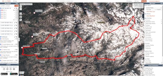
Trip type: Expedition 11-dayMonday, September 11 through Thursday, September 21, 2023Fitness level: HighTechnical level: MediumGuides: Scott Christy and Mikaela Osler Prices: go here Waterfall along Boulder Creek
And a route map showing the planned route, below. Based on the group’s abilities and the actual conditions, the route can be extended or shortened.
About the guides and groupEspecially on an 11-day trip, your company matters. Scott is one of our most seasoned guides with over 200 weeks of experience as an outdoor educator. He is professional in everyway: his leadership, communication, teaching, group management, and personal skills. Mikaela joined our program last year and immediately fit in. She has thru-hiked the Triple Crown and set FKT’s on the Colorado Trail and Long Trail.
If you inquire, I can give you bios for the current group members. At the time of this publishing, they’ve all been on at least one trip with us before, and we’re very confident in their abilities.
 Scrambling through the Cat Walk on the Bailey TraverseHow to apply
If you are ready to join, submit an application.
If you have questions first, contact me.
The post Spots available: 11-day Olympic Traverse, September 2023 appeared first on Andrew Skurka.
May 27, 2023
Ask Us Anything: Backpacking the High Sierra in 2023
Last week I wrote about the High Sierra’s record-breaking 2023-23 snowpack and its implications for trip planning, gear selection, and essential skills. In short, this season will be far from normal. Are you ready for that?
This week Katie Gerber and I are hosting an “Ask Us Anything” online event to answer your questions about backpacking in the High Sierra this season. Our primary goal is to help make your trip safe(r), and hopefully more feasible and fun, too.
Event detailsWednesday, May 316 PM to 7 PM Pacific Time (7pm MT, 8pm CT, and 9pm ET)FreeContentWe’d like to stay focused on the:
Likely conditions during the 2023 backpacking season, andTheir implications on trip planning, gear selection, and essential skills.But we can also answer more standard questions, like about permits, recommended routes, and thru-hiking logistics.
We want the discussion to be driven by viewers, by way of questions. During any lulls, Katie and I will be prepared with quick tutorials on Sentinel satellite imagery, river levels, and my creek hazards map and list, and more.
Send us your questionsAlready have questions? Email them to highsierra@andrewskurka.com, and we’ll try to answer them during the broadcast.
How to watch and participateTo watch on YouTube, click here.
To ask questions, use the chat tool in the upper-right corner of the window.
I will post a recording of the stream here afterwards.
 About Katie Gerber
Katie has thru-hiked the Pacific Crest, Continental Divide, Oregon Desert, and Colorado Trails, as well as the Wind River High Route and an end-to-end thru-hike of the Grand Canyon. She’s been guiding for me since 2020 and joined this year full-time as the Co-Director.
About Andrew SkurkaMost pertinent to this conversation, I have been backpacking in the High Sierra for nearly twenty years, including as a guide for twelve. I’ve thru-hiked the JMT, the JMT/PCT through the High Sierra (twice, including once in the second half of May), and the Sierra High Route; and I wrote the guidebooks for the Kings Canyon High Basin Route and Yosemite High Route.
The post Ask Us Anything: Backpacking the High Sierra in 2023 appeared first on Andrew Skurka.
May 25, 2023
High Sierra record snowpack: Implications for trip planning, gear selection, and skills
As atmospheric rivers crashed into the High Sierra during the 2022-23 winter, I had two primary reactions. I was:
In awe of the precipitation amounts, with totals eventually reaching 237 percent of the state-wide average snow water equivalent on April 1; and,Increasingly concerned about the impacts of this record-breaking snowpack on the summer backpacking season — and also on my livelihood, since I was planning to operate seventeen guided trips in this area starting in the third week of July.In 2023 backpacking trips in the High Sierra will be more difficult and risky than identical itineraries in past seasons. However, it’s possible to accurately predict, entirely avoid, and/or safely manage the challenges. Personally, I think this approach is more productive than succumbing to fear mongering (this 2018 post remains relevant today) or letting fears of the unknown grow out of proportion.
In this post I will explain how to have safe and fun trips in the High Sierra by explaining the:
Likely conditions, and Implications of these conditions on trip planning, gear selection, and essential skills.This post shares content with the extensive early-season tutorial that I wrote in 2017. This one is more succinct and updated, and reflects six additional years of gained backcountry wisdom.
What are the likely conditions?In normal yearsAfter winters that track close to the the historical averages, in the high country of Sequoia-Kings, Inyo, Emigrant, and Yosemite, we’d expect:
Water levels to peak around June 1 and to be reasonably safe by July;Snowpack to melt off throughout June, leaving only small patches to finish melting in July and August;Mosquitoes to emerge in July, when the groundwater finally warms up, and fade in August as their breeding areas dry out.In 2023The arrival of normal conditions will be significantly delayed this season. Instead, most backpackers will experience some “early-season conditions” that normally prevail in May and June that blur the lines between backpacking and mountaineering. Specifically, I’m expecting:
1. More extensive snow coverage, because it will take longer for it to melt off.Many more weeks of summer temperatures will be required to melt this extreme snowpack. High and north-facing slopes will probably remain snowbound into next winter. As a result, expect:
Slower travel, due to demanding navigation, awkward sun cups, inconspicuous trail corridors, and a generally slippery and punchy walking surface. In May and June, before the snowpack fully consolidates, post-holing will be commonplace in the afternoons, or earlier after warm nights.Extreme sun exposure, especially when above tree line, because snow is highly reflective.Increased risk of injury due to little slips, big falls and slides, collapsing snow bridges, rotten rock moats, and post-holing onto unknown surfaces below.Large cornices on the leeward side of steep passes such as King Col or Longley Pass. Nearly complete snow coverage still on the north of Selden Pass on the John Muir Trail/Pacific Crest Trail in late-June 20062. Overabundant groundwater
Some of it will percolate into the soil, which is parched after multiple years of drought. But because the High Sierra is composed of impervious granite and because the high country has little top soil, most of it will flow into streams and creeks that eventually form large rivers like the Kern, Kings, San Joaquin, Merced, and Tuolumne. As a result, expect:
Relatively swift and/or deep water crossings;Flooded meadows and saturated ground; and,Wet feet, for most or all of the day.3. A delayed and long-lasting mosquito seasonThe bugs will hatch after the groundwater becomes warm enough. The volume of cold snowmelt will delay this from happening on a mass scale.
Once the mosquitoes emerge, they probably will stick around until the first frosts in late-September or early-October because many areas will never dry out this season.
Mosquitoes are most active in the evening, seeming to enjoy their supper while you’re having yours. They don’t like temperatures below about 50 degrees (like at night) and they struggle in strong winds.
4. Highly variable conditionsSnow levels, snow consistency, snowmelt rates/river levels, and bug pressure will change throughout each day and from week to week, and vary too with elevation and slope aspect. These dynamics need to be considered when planning whole trips ahead of time and when planning each day.
Trip planning at homeIn advance of your trip, what changes should be made and how can conditions be monitored?
Itineraries and permitsKeep tabs on land agency press releases and social media accounts to monitor openings, closures, and developments. For example, Yosemite recently subtly indicated that a late-June or early-July opening of Tioga Road was unlikely, putting all Tuolumne Meadows wilderness permits at risk through mid-July-ish.Soloists and small groups on non-commercial trips might consider obtaining walk-up permits rather making reservations on Recreation.gov, so that plans can remain flexible until the final weeks before. To avoid last-minute rushed planning, have prepared a Plan A, B, and C. Put the unused plans on a shelf for later in the season or for another year.Identify obstacles on your route for which you will be under-skilled or under-equipped, like excessive snow coverage, swift crossings, or steep snow-covered passes. Have detours ready, or plan a new route that is lower and that poses fewer challenges.Frontload the most difficult elements early in the trip so that you have time to reverse your route. Normally, these sections would go at the end, when you’ve eaten through your food and found your trail legs. But in these circumstances, you may be pressured into doing something foolish so that you exit on time.Reduce your expected mileage and vertical each day, to account for slow travel and potential delays. If you end up being too conservative, eat up time with side trips and summits.Snow coverageTo monitor snowpack across the western US, throughout the winter I primarily use:
For California, the Daily Regional Snowpack Plots from the California Department of Water Resources, andFor all other states, the Interactive Map from USDA.When I’m planning early-season trips though, another data source becomes much more valuable: Sentinel Satellite imagery. It gives me access to:
Current snow coverage, using the most recent imagery; and;Historical snow coverage, using the archives.CalTopo (long-term review) includes Sentinel imagery in its Pro subscription ($50 per year) and has imagery stretching back to January 2017. Select “Sentinel Weekly” base in the Base Layers dropdown menu. New imagery is uploaded weekly.
Imagery from 2017 and 2019 will best inform you of likely snow coverage in 2023. Conditions this season will likely be a few weeks behind these other two seasons, since the 2022-23 was notably wetter. The exact delay will became more evident in late-June or July when more bare ground emerges.
 Sentinel Satellite imagery from July 16, 2017, of the Emigrant Wilderness, which I can use to speculate about snow coverage during our trips that start on July 20, 2023.Water levels
Real-time data for the most renown crossings in the High Sierra — like the South Fork of the Kings between Pinchot and Mather Passes, Bear Creek north of Selden Pass, and Rancheria Creek in Yosemite’s Kerrick Canyon — is unavailable.
Gauges further downstream are suggestive of what’s happening upstream. Refer to my High Sierra Creek Hazards resource for a list, under the section “Data: Current Levels.”
Speaking of, the Hazards list and map is a definitive resource. Use it before you go when planning your route, and as you go to set your expectations and daily schedule.
 Bug pressure
For the information about current bug pressure, read recent online trip reports and call wilderness offices. But, honestly, these resources are not consistently accurate — rangers may not get out as much as you’d think, online information may not be timely, and the reported conditions may not be relevant to your own itinerary. It’s more productive to simply:
Be properly prepared for bug pressure; and,Understand where and when they are most likely to be — near slow or standing water, in warmer temperatures, with little wind, and especially in the evening.Gear selectionCompared to a normal summertime kit, what changes should be made?
ClothingFor sun protection, have:
Full-length hiking pantsLong-sleeve hiking shirt with a hood (which is better than a collared shirt with a large hat)Sun glovesGlacier goggles, or at least dark wraparound sunglassesZinc-based sunscreen for exposed lips and facial skinFor bugs, I recommend at least having a:
Factory-treated permethrin hoody like this one from LL BeanHeadnet made of mosquito mesh (not no-see-um)Gaiters or treated socks, because mosquitoes are weirdly attracted to nasty shoes and socksTreated pants are optional. Bites below the waist are much less common, probably because mosquitoes struggle to get through the fabric.
You may opt to bring shorts, because they’re more airy and less restrictive than pants. However, they offer no defense against bugs or sun, leaving their usefulness to bug-free wooded sections.
My experience is that DIY permethrin treatments are less effective, in terms of overall effectiveness and in longevity. If you have beloved non-treated hiking clothes, send them to Insect Shield ($9 per item or $120 for 10-15 items).
 Amy in Alaska, sporting a permethrin-treated knit hoody and headnet.Footwear
Hiking shoes should have a/an:
Aggressively lugged outsole, for better traction on slick snow;Durable upper, for abrasion resistance while kicking steps and wearing crampons;Breathable upper, for rapid dispensing of water after crossing creeks and walking through flooded meadows; and,Stiff midsole, for better edging and easier step-kicking.Carry two pairs of socks:
One pair for hiking that gets wet and stays wet; and,One pair for sleeping that stays dry inside your pack during the day.I prefer wool socks, which are observably warmer (but not “warm”) than synthetic fibers like nylon.
For additional thoughts on early-season footwear, read this post.
Shelter and sleep systemIf the bugs have hatched, then bring your shelter’s bug-resistant inner or a water-resistant bivy sack. Defending yourself from a lone mosquito with just a headnet is stupid light.Have a reliably waterproof floor or groundsheet so that you can sleep on soggy ground.Bring a warmer sleeping pad (e.g. XLite instead of Uberlite) in case you must camp on snow.Even though you may be camping on snow and be surrounded by snow, the weather in the High Sierra in July and August is typically benign. My goal each season is to cowboy camp every night; for nights when I can’t, I have an open-sided A-frame tarp.
Trekking polesThis is an essential item for early-season conditions. In addition to their normal usefulness, they’re good for:
Extra traction on slick snowA third and fourth point of contact when crossing streamsProbing snow bridges and rock moats before weighting themSelf-arresting and glissade-braking on moderate slopes, in lieu of an ice axeUltralight trekking poles like the Gossamer Gear LT5 should left at home. Instead, go with robust poles like the Black Diamond Alpine Carbon Cork (long-term review) or the Cascade Mountain Tech Quick Lock (long-term review).
Remove the mud baskets and the snow baskets. With baskets, their functionality is partially lost. For example, they’re less effective for probing snow and they add drag while crossing creeks.
FloatationSnowshoes may be helpful in June, before the snowpack has fully consolidated. But it’d be more productive (and lighter) to start before dawn each day, rest in the afternoon, and put in more miles in the evening after the snow has firmed up again.By July the snowpack is very consolidated, and extra floatation is not helpful. However, be careful of rotten snow that is melted through (from the top and bottom), like at the edges of snow fields.TractionBring traction if you expect extensive snow travel or isolated sections of high-risk snow travel.The lightest option worth consideration are the Kahtoola Microspikes (and similar). They have good purchase on firm snow surfaces and flatter ground, but flounder in looser snow and on steeper grades.The Kahtoola K-10 (and similar) are heavier and may be overkill for easy itineraries, but they’re much more capable.Ice axeIf your route includes steep slopes with fall potential, an axe is helpful if not required.For regular use, select a heavier axe with a longer shaft like the Black Diamond Raven Pro (or similar).For just-in-case purposes, an ultralight axe like the Petzl Glacier Literide (or similar) may be enough. Steve ascends the Northeast Gully on the Pfiffner Traverse in late-June. An ice axe and crampons were critical for this steep 600-foot pitch.Essential skills
You’ve planned a practical route and you’ve selected appropriate gear. To have a successful trip, skills are the final thing you need.
Decision-makingOnce out there, don’t feel compelled to stick to your plan. Instead, be ready to:
Adjust to the actual (not predicted) conditions, like by adding or removing distance, vertical, and difficulty;Turn around if you’re excessively uncomfortable or at risk. This is an important skill; it’s a sign of wisdom and maturity, not failure.When making decisions, keep in mind the abilities of your weakest group member. The plan must be appropriate for every person in the group, not most of them.
Snow travelStart early each day, to take advantage of the snow having firmed up (or frozen) overnight. Once the snow softens, the snow becomes punchy and slushy, and post-holing will be more common.Avoid steep slopes in the morning after cold nights, because they will be frozen and have higher fall risks. Give these passes some time to soften up.Attempt to finish your day at lower elevations, where you are more likely to find snow-free and dried-out ground.Be aware of collapsing snow bridges, unsupportive rock moats and snowpack edges, wet avalanches, steep cornices, among other hazards.Comfort on steep snow is personal, and confidence is gained with experience. Beginners with a snow sports background (e.g. skiing, snowboarding) will probably take to it more quickly.Specific skills to learn include:
Kicking steps,Using the “edges” of your shoes for stability on steep slopesBoot skiingGlissadingSelf-arresting with an axe and with trekking polesSelf-belaying with an axeChopping steps (very rare in summer conditions) Walking on concrete-hard snow below Muir Pass in mid-May, early in the morning. A few hours later in this same spot,, I’d be postholing to my waist.NavigationIf a trail is snow-covered above treeline, it’s de facto off-trail navigation. Know how to use your navigational tools: topographic map, magnetic compass, time piece, altimeter, and GPS.Below treeline, it’s more efficient to follow the trail even if it’s snow-covered. Use clues like saw cuts, constructed benches, and old blazes to follow the corridor.
For more early-season navigation tips, read this post. For my definitive tutorial on navigation, go here.
 In early-season conditions, the trail is just a tool. If it’s there, great. If not, oh well, you can manage without it.Avalanche awareness
Summertime avalanches are very rare, and this is not the risk that keeps me up at night. However, it’s still helpful to know the warning signs for wet slab avalanches:
Slopes between 25 and 35 degreesPinwheelingSouth-facingRecent avalanches in similar conditionsThe slope-angle shading overlay in CalTopo can help you identify slopes.
Foot careExpect wet feet everyday, perhaps all day. And often very cold, too. It’s essential to take care of them. Follow this regimen.
To keep my feet warm and dry in camp without needing to carry dedicated camp shoes, I bring 2 mil bread bags. We buy these bags for our clients, available in 100-count only. Here’s the routine:
After arriving in camp, I remove my shoes and socks to let my feet dry out.Once they’re dry, I put on my dedicated sleeping socks, and I layer the bread bags over them.I put my entire foot (with dry sock and bread bag) back into my wet hiking shoes. To keep our feet warm in camp, we wore bread bags between our dry sleeping socks and our wet shoes.River crossings
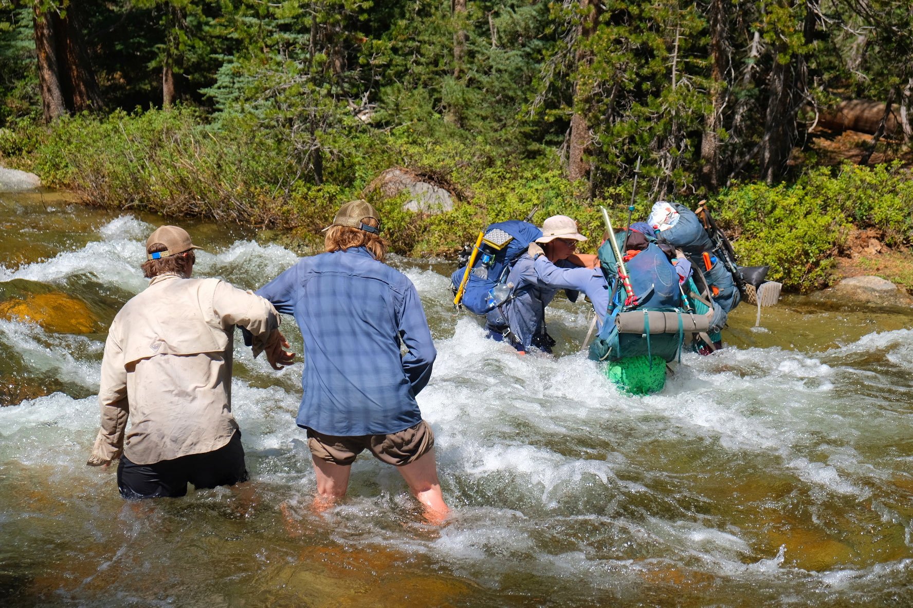
Take crossings seriously. They can be enormously risky, and in 2017 were responsible for two hiker deaths.
Learn to predict the size and swiftness of crossings:
Water levels will be highest in the evening, carrying a full day of melt.The volume of snowmelt is proportional to a watershed’s size, with some variability based on slope aspects and elevations.Where creeks drop elevation quickly, the flow will be swift. Through flat-bottomed meadows, they meander slowly.Higher in a watershed, crossings will be smaller, because the snowmelt has not yet fully collected.Do not assume that the official trail crossing is safe. Instead, learn to identify safer options, and be willing to invest time in scouting trips up and down the creek where it:
Is wide and slow, not narrow and fastDivides into multiple braids, separated by islands or barsHas no hazards downstream like waterfalls or strainersIs bridged by large logs or sturdy snowHas slow-moving eddies on both shores, so that you can easily step in and climb out, instead of cut-banks that indicate deep and swift flowsHas a gravel-y bed surface, not cobbles or bouldersLends itself to crossing downstream at a 45-degree angle, which requires infinitely less energy than crossing perpendicularly or especially upstream.When crossing solo, use trekking poles to maintain a tripod at all times, with three points of contact, e.g. two legs and one pole, one leg and two poles.
Groups can cross creeks that soloists cannot, or not as safely. Specific techniques include the:
Eddy or train method, demonstrated hereTriangle method, shown in this imageArm-in-arm, like in this imageFor more river crossing discussion, read this post.
 In late-June after a very wet winter, I crossed I crossed Evolution Creek at the meadow about a half-mile above the trail crossing. Here, at 5 PM, it was MUCH safer. The trail crossing would have been a swim.Bug management
Mosquitoes are annoying but entirely manageable:
Avoid the areas where they are most likely to be, especially when selecting a camp.Let your equipment protect you, like your permethrin-treated clothing, headnet, and fully enclosed shelter.Accept it for what it is. It may be satisfying to swat at or kill mosquitoes, but that has no effect — they are plenty more where they came from.Have questions aboutThe post High Sierra record snowpack: Implications for trip planning, gear selection, and skills appeared first on Andrew Skurka.
May 22, 2023
More damaged bridges in the High Sierra
Two more reports of damaged bridges in the High Sierra have emerged. I suspect we may be looking at a few more before the water levels drop in July or August.
I’ve updated my High Sierra Creek Hazards resource with these updates already.
The first bridge spans Woods Creek in Sequoia-Kings. It’s on the JMT/PCT and Rae Lakes Loop, and it’s a critical one — there’s a lot of water moving through here, and it’s moving quickly. Here’s the original report. JMT/PCT hikers can bypass this bridge by staying on the east side of the creek, its South Fork as well as its main stem (that flows south off Pinchot Pass). But it’s an ugly alternate: expect extensive talus and brush.
The other bridge is over the Middle Fork of the San Joaquin near Red’s Meadow on the PCT/JMT. Here’s a report and photo. The alternate is easy: walk the road between Red’s Meadow and Agnew Meadow.
The post More damaged bridges in the High Sierra appeared first on Andrew Skurka.
May 18, 2023
Detouring: San Joaquin River bridge alternates
During a flight tour in April, the National Park Service discovered that a critical bridge over the South Fork of the San Joaquin had been damaged. For photos, refer to the PCTA website.
This bridge is in the northwestern corner of Sequoia-Kings Canyon National Park, just south of the boundary with Sierra National Forest, and it’s critical to hikers on the Pacific Crest Trail and John Muir Trail (which overlap in this section). Hikers have three options now:
Use the bridge, which is clearly damaged;Ford the South Fork, which most would consider to be a death wish; or,Detour around the bridge, using one of many on- and off-trail routes.Let’s look at each option more closely.
1. Use the bridgeSince the news originally broke, I’ve not seen further updates on the condition of the bridge. In the photos, which were taken from a helicopter, it appears somewhat intact, so maybe it’s still usable if your DNA is more akin to a monkey than a horse.
Planning to use the bridge seems like a risky option though:
It could be washed out by higher water levels;NPS may remove it before or during the season; NPS could station a ranger on-site, issuing warnings and/or fines; and,If you slipped off, it could be fatal and you’d not get much sympathy.It’s worth pointing out that relevant organizations (NPS, PCTA, JMT Wilderness Conservancy) are universally discouraging hikers to plan alternate routes that don’t use the bridge.
Don’t expect this bridge to be replaced in 2023. The replacement process will entail extensive engineering, installation team logistics, and probably a wilderness study.
2. Fording the South ForkThis will be a dumb idea for most of the 2023 season. But you might be able to get across it:
During colder weather in May, when the snowpack is still melting solid at night; or,After early-September, when there will be less run-off and near-freezing nighttime lows.In both cases, cross in the morning, when water levels will be lowest.At the location of this bridge, the South Fork contains run-off from its starting watershed (framed in by the Le Conte Divide, the Goddard Divide, and an unnamed ridge that divides the South Fork and Evolution Creek) as well as Evolution Creek, a large but relatively smaller tributary. The river drops about 125 vertical feet per mile through this section, with no apparent areas where it slows down, like meanders through a wide-bottomed meadow.
I’ve crossed Evolution Creek twice after wet winters (late-June 2006 and mid-August 2011), both times at Evolution Meadow, which is significantly safer (i.e. slow-moving, though perhaps deeper) than the trail’s official crossing point about a half-mile further downcanyon. In 2006 it was naval-deep; in 2011 it was knee-deep. Now, imagine crossing a river that’s twice the volume and moving swiftly.
3. DetourI’ve updated the High Sierra creek hazards resource with five potential alternates. These have been discussed elsewhere too (like here, here, and here), if you’re looking for more information than I will provide.
A. Bishop-Piute PassThis all-trail route leaves the JMT in LeConte Canyon and rejoins it at the confluence of Piute Creek and the South Fork, a few miles downstream of the bridge. You’ll miss Muir Pass and Evolution Basin, two of the JMT’s highlights, but get Dusy Basin and Piute Pass, which are equally cool. Also, you can catch a ride to Bishop for resupply and a shower.
I’m uncertain how Inyo National Forest will feel about this detour. Currently, the number of hikers who can depart each day for Bishop Pass and Piute Pass are 36 and 30, respectively. Will JMT hikers need one of these trailhead permits? I don’t know.
B. Hell for Sure PassThis option allows hikers to experience more of the JMT/PCT than the Bishop-Piute alternate, it’s entirely on-trail (if following the B1 version), and there are no wilderness permit uncertainties. But it:
Adds more miles,Is less aesthetic, andOffers access to fewer services.To shorten the distance, travel off-trail from Wanda Lake to Davis Lake and the South Fork (shown on the map as B2). This route looks straightforward except for just east of the South Fork — there is some steep terrain and some gullies, and also a crossing of the South Fork (which will be much smaller this high up in the watershed).
C. Over the topThis off-trail route is untested, but it looks good on satellite and it’s very direct. Also, it will melt out early because it’s south-facing.
Don’t expect it to be straightforward though, as it:
Involves side-hilling across steep slabs, Cuts across multiple small drainages, and,Passes above and below steeper terrain that could be problematic if you get off-route.It departs the JMT at the Evolution Creek crossing and rejoins the JMT on the northeast side of the South Fork.
D. Alpine ColThis is a well established off-trail pass, but I’ve not personally been on it. It’s described as Class 2 in Secor’s definitive guidebook and by High Sierra Topix. Based on photos, this rating looks accurate.
The north side of Alpine Col will remain snow-covered for most or all of 2023, based on satellite imagery from past wet winters like 2016-17 and 2018-19. Traction will probably be helpful, and possibly required if the snow is firm. An ice axe might be desired by those uncomfortable on steeper snow.
E. Snow Tongue PassThis is expert-level, loose Class 3, on the north side. It’s not difficult to reach the pass from the south, but the north side is STEEP (about 45 degrees) and will be entirely snow-covered for most or all of 2023. Axe and crampons, and the knowledge to use them, full stop.
The post Detouring: San Joaquin River bridge alternates appeared first on Andrew Skurka.
May 16, 2023
One spot available: 7-day trip in Alaska’s Brooks Range
Due to a recent cancellation, a spot has become available in the Alaska 1B group. This trip has been full since January, when we first accepted applications. Trip details:
Wed, June 21 through Tue, June 277 days/6 nights in the fieldGates of the Arctic National Park, Brooks Range, AlaskaGuided by Jeff Wohl and Hunter HallExperience level: Intermediate and advancedFitness level: 3 – MedianIf you need to check your schedule, base your plans on these details:
Arrive in Fairbanks on Tue, June 20, ideally in time for a 4pm gear check with me/Andrew and the guidesDepart Fairbanks on Tue, June 27 (or shortly after midnight on Wed, June 28) on a red-eye flightThe group will meet in Fairbanks, fly to Bettles on a regional flight, and then fly into the field using a bush plane with pontoons. You will walk to a native village within the park, entirely off-trail until reaching the outskirts of a native village inside the park from where we fly back to Fairbanks.
Some other details:
PricesLogisticsClient trip reports: Nathan McNeil, Ryan Massopust, Sarah McClellandIf you’d like to apply, use the application form.
If you have questions, contact me or leave a comment.
The post One spot available: 7-day trip in Alaska’s Brooks Range appeared first on Andrew Skurka.


