
Jack Erickson's Blog, page 5
February 3, 2013
Coffee farm, Costa Rica
Coffee Farm

Lucy crushing coffee beans
Costa Rica coffee if world-famous, grown on terraced plantations on mountains facing the Pacific Ocean and Caribbean Sea. The ideal temperature, moisture, and soil produced plump ,red coffee beans that produce rich, flavorful coffees.
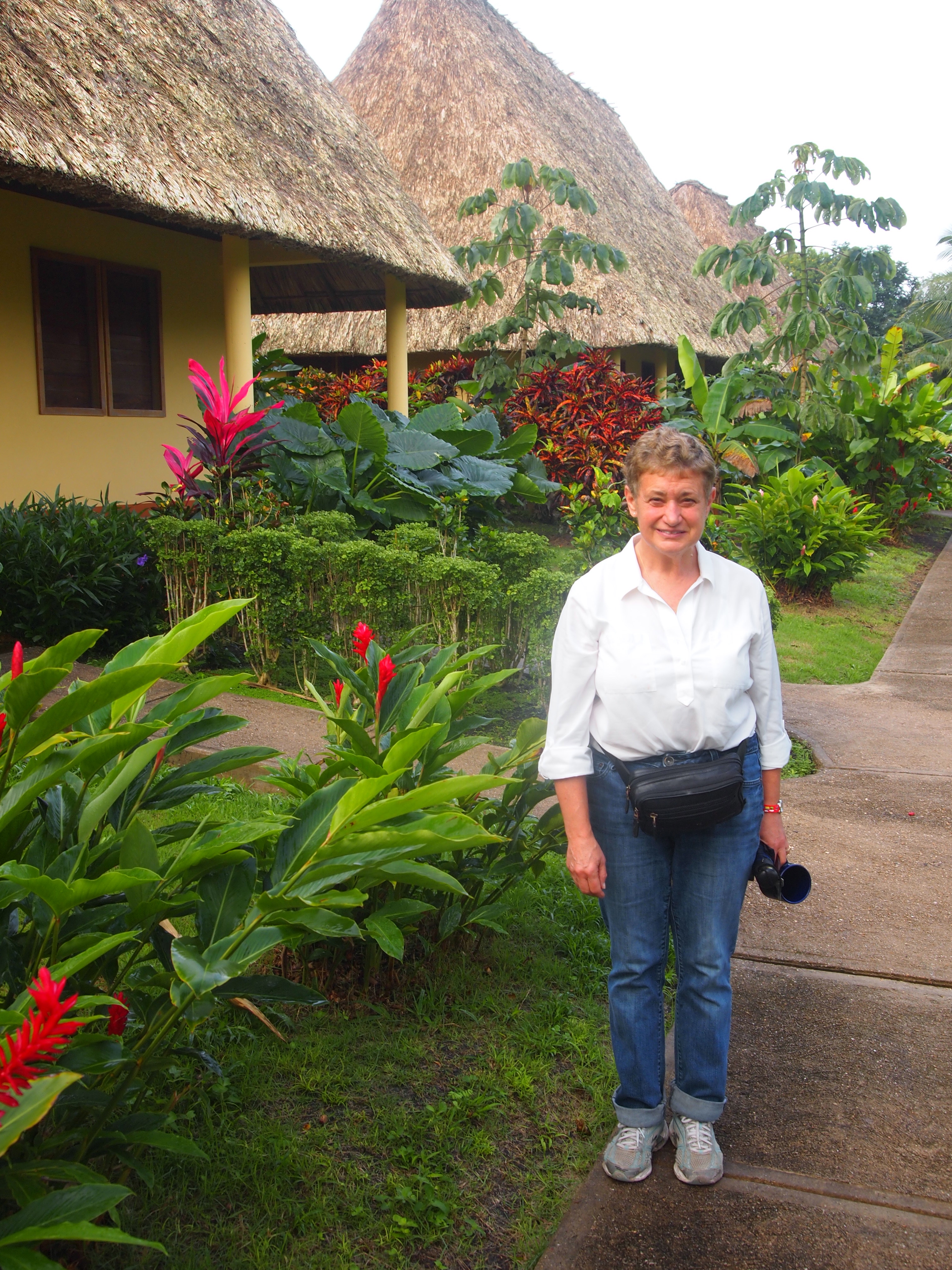
After our cloud forest trek, we boarded a shuttled bus for a coffee farm on a hillside below Monteverde. On the drive down the mountain, we had a wonderful view of the Pacific coastline to the west and the Puntarenas peninsula.

Puntarenas peninsula from Monteverde
Don Juan Laiten
Our host was Juan Laiten, who farms 8 hectares on a hillside of which only 3 hectares are planted in coffee trees. Juan is part of a local cooperative of small organic coffee growers in the valley.

Juan Laiten, small coffee farmer

Touring Juan’s coffee farm
Cherry coffee beans
Coffee beans grow on branches of shiny green plants that are cropped to about 4 feet high. Farmers prune trees during the year to keep trees from growing too tall. Pruning makes it easier to pick with beans growing about waist-high.

Immature ‘green’ coffee beans

Cherry beans ready to pick

Cherry beans, ready for harvesting
The harvest season extends several months with mature berries turning red when they are ready for picking. Pickers walk down rows daily, lift branches, and pick only mature ‘cherry’ berries. If a picker’s box contains too many green beans, he is penalized and his pay drops.
Cleaning and husking cherry beans

Mature coffee ‘cherries’
Milling coffee beans
Cherry coffee beans are dumped into a mill where they are crushed, with the moist husk being separated from the bean. The cherry husk drops into a bucket where it is taken out and used as compost around the farm.

Crushing cherry coffee beans to remove skins
The white ‘husks’ are washed in the milling process and spill into a bucket where they are examined for whole husks then poured onto wooden trays and laid out in the sun to dry.

Washed beans out of mill, ready for drying rack
Drying beans

Juan explaining drying process
Tan coffee beans are dried on flat trays exposed to the sun for six or seven days. When they are dry and easy to crack open, they are put through a soft grinder which crushes the dry husk, exposing a small brown bean with the distinctive crease down the middle. This is the true coffee bean ready for roasting. Dried beans are taken to the local cooperative where they are roasted and packaged for shipping around the world as ‘free trade’ coffee.

Rack of drying beans
Coffee, bananas, sugar, beans,
Juan is a small farmer who also grows sugar cane, bananas, and vegetables for his family. Tall banana plants shade rows of coffee beans.

Banana tree on Juan’s small farm

Almost ready for picking
Coffee tasting with Juan
After walking through Juan’s coffee farm, we went along a jungle trail where he explained that part of being in a cooperative is preserving the natural environment. Indigenous animals, birds, butterflies, and insects are able to move through the valley and not be ‘boxed’ in by clear-cut, industrial farms.

Juan serving us fresh coffee and banana bread at his ‘hacienda’
Coming out of the jungle, we came to a small ‘hacienda’ that served as a tasting porch for guests. Juan had prepared fresh coffee for us to taste as well as fresh banana bread. He poured steaming cups for us and passed them around. It was delicious and very fresh, even for me who likes a spot of milk and a little sugar in my morning ‘cuppa.’

Mmm . . . good coffee!

Freshest coffee we’ll ever enjoy
Our setting for the coffee tasting was surrounded by banana trees, and jungle flowers, ginger, hibiscus, wild orchids, and poinsettia.

Surrounded by flowering plants around Juan’s ‘hacienda’
Juan’s cottage
Juan’s family lives in a small wooden building surrounded by tall, native poinsettia plants. When we walked down the dirt road to our van, I turned around and snapped a photo of the modest setting. Juan is a true pioneer, eking out a living on a few acres of coffee plants and vegetables he grows for his family.

Poinsettia plants outside Juan’s cottage

Road into Juan’s coffee farm
* * * * *
Welcome to our Central American travel adventures. Please share your comments with us, we’d love to
hear from you.
Next: On the beach at Manuel Antonio


February 2, 2013
Monteverde Cloud Forest Reserve, Costa Rica
Monteverde Cloud Forest

Monteverde cloud forest
Two national parks in northern Costa Rica feature different natural wonders, Arenal Volcano, and the Monteverde Cloud Forest. The two national parks border each other, but there are no roads between them. It’s rough country, with impenetrable jungle forests, steep mountains, and narrow, rocky ravines.
To travel from one to the other, you take a shuttle bus to Arenal Lake, cross over to the southern shore, and drive an hour and a half over winding, rocky road to the town of Monteverde.
Arenal Lake

Arenal Lake

Lucy loves boat rides

Boating across Arenal
Trapp Family Lodge

View from our third tier jungle ‘cabin’ at Trapp Family Lodge
We stayed about 7 kilometer in the mountains above Monteverde. the road was rocky and muddy, but when we arrived at the Trapp Family Lodge, we were thrilled how modern and comfortable it was; a great restaurant, small bar, lobby, and helpful staff. We had to climb winding stairs and paths to get to the third tier looking down over the lodge.
Our room was a corner with full picture windows looking out at the cloud forest and the clouds constantly moving down from the alpine ridge above us. It was mid-January, but temperatures were in the 40′s, windy, and rainy, especially at night when the fierce winds whipped trees around so forcefully I thought we’d had one crash down on our lodge. But it didn’t happen, the tall, vine-covered trees are acclimated to the strong winds.

Our jungle ‘cabin’ was high on the far right corner. Nice place with full windows looking over the cloud forest.

Morning clouds rolling down from 5,000 ft. continental divide. View from our Trapp Family ‘cabin.’
Monteverde Cloud Forest Reserve
Our interest in traveling to the 1440 meter high spine of Costa Rica was to visit the Monteverde Cloud Forest Reserve, started by a group of American Quakers from Alabama who settled here in the 1950′s and began a successful dairy and cheese manufacturing enterprise.
When farmers began encroaching on the forest, the Quakers organized an effort to preserved the virgin cloud forest. The united with scientists to form a private environmental and science research center to protect 14,000 acres of virgin forest.
Tours are offered every day which lead through 4 kilometers of trails and sky bridges over deep ravines. Guides point out the many species of trees, wild flowers, insects, birds, and occasional mammals. Our guide was very knowledgeable and stopped several times along the trail to point out trees, vines, and wildflowers. Most trees are layer with various species of plants, epiphytes, flowers, wild orchids, and vines, many that hang from branches, and form roots for water and nutrients.

He shared an amazing fact that some mature trees have more than 4,000 plants or epiphytes living on them, so dense it’s difficult to see the bark of the host trees. Costa Rica ha some 1400 species of wild orchids, small, growing on trees, with intense red, orange, purple blooms.


Tree fern

Hummingbirds at nature preserve
Sky Bridge

Starting across the sky bridge. Yes, it’s windy and rainy, but that didn’t dampen our spirits.
Deep in the cloud forest, we climbed stone steps to the top of a hill, leading to a metal sky bridge across a ravine. Neither one of like heights, but we started across the bridge, holding the metal cable to keep our balance. But the sky bridge was sturdy, and half way across, we were able to lean down and see the canopy about 20 meters below us. Yikes!
After a few minutes on the bridge, I leaned over and pointed my camera down to capture the sweep of the ravine and trees far below. Nobody push!

Canopy of tropical trees below the sky bridge

View from sky bridge

That’s a loooong bridge to cross over and back
New Friends

Meet Dave and Camie, cloud forest friends
We met an interesting couple from North Carolina, Dave and Camie. We walked along with them, sharing stories of travel, families, and careers. After our hike, we invited them to dinner at Trapp Family Lodge that evening. More interesting conversation followed and we invited them to Monterey when they come to the West Coast later this year for a wedding.
* * * * *
Thanks for you interest in following our month in Central America. Please share your comments with us, we’d love
to hear from you.
Next: Coffee farm in Monteverde


January 29, 2013
Arenal Volcano, Costa Rica
Arenal Volcano

Arenal volcano under heavy cloud canopy
Our first Costa Rica destination was in the northern mountains about a three-hour drive from San Jose airport. Driving in remote areas of Costa Rica is risky and challenging. There are no road signs and every village and rural road has several turn offs with no names or markers. Much better to take a shuttle which we’d arranged when we were planning our trip. On the drive from San Jose, our driver must have made three or four hundred turns in the hills and along narrow country roads. At night, it’s dark with no moonlight. The only lights are those burning in rural homes or a few neon signs in front of markets, restaurants, or gas stations.
We’d arranged to spend three nights at Arenal Paraiso, in the hills 7 kilometers above the village of La Fortuna. The short drive from La Fortuna passes many similar jungle lodges and resorts, all in beautiful settings with dense foliage, blooming flowers, and native birds. Several lodges had spas or hot springs; this is geothermal country in Arenal Volcano National Park.

Our jungle cabin at Arenal Paraiso

Path to our cabin

Cooing birds outside our cabin every morning

Arenal Paraiso lodge
The view from our patio was of cloud covered Arenal Volcano which violently erupted in 1968 after four centuries of being dormant. The eruption wiped out three village, killed 87 people, and created four new craters. Arenal is an active volcano, with eruptions and explosions occurring as recently as 1998.

Photo of Arenal without cloud canopy

Arenal erupting at night
Arenal is a relatively new volcano, estimated to be 7500 years old, a brief time in geological history. Costa Rica has four active volcanoes and several dormant ones, mostly in the north.

Afternoon clouds over Arenal
Sloth
One afternoon during lunch at the lodge restaurant, we saw folks outside pointing up in the trees. We went out to see what they were looking at and saw a sloth about ten meters above us in the trees. He was moving slowly, branch to branch, until he settled into the crook of the tree. Delightful site, our first view of a sloth in the wild.

Sloth climbing tree, little right of center

Sloth climbing branch – slowly.
Our second day we faced a heavy downpour that lasted several hours. We canceled a zip line and jungle canopy tour, not wanting to get soaked and slip slid on muddy trails.

No special effects, looks supernatural
After the rain let up, we took a taxi into La Fortuna to have lunch, walk in the park, and get a taste of a rural Costa Rica village. We had another shower when were in the village and ran for the sanctuary of a small church where others were huddled on a veranda. The catholic church was open and well light with open windows and side doors.

La Fortuna church from village park
On to Monteverde

Lucy loves boat rides
After three nights at Arenal Paraiso, we took a bus to Lake Arenal where we boarded a small boat for an hour trip to the southern shore in the national park. On the boat ride, we had another view of Arenal.

Arenal volcano from Lake Arenal on way to Monteverde

When we arrived on the southern shore of Lake Arenal, we got in a van with another half-dozen travelers for an hour and a half bumpy ride over Costa Rica rural roads. Out destination was the cloud forest at Monteverde where we’d spend the next two nights and take a tour in a nature preserve at 5,000 feet elevation. We had no idea we’d be buffeted by strong winds, dense clouds, and rain.
* * * * *
Join us on our month trip to Central America. We’d love to hear from you!
Next: Cloud forest at Monteverde


January 28, 2013
Horse back riding, Costa Rica
Horse back riding in shadow of Arenal Volcano

On the trail
We arrived in Costa Rica after a long day of travel; two boat rides from Ambergris Caye to San Pedro then to Belize City followed by two flights, one to San Salvador where we switched planes to fly to San Jose, Costa Rica. Our driver met us around 4 PM and took us three and a half hours north to Arenal Paraiso, a lodge in a national park with a view of Arenal volcano from our patio.
Our first morning in Costa Rica, we took a horse back ride through the jungle, crossing creeks, across pastures, passing rural settlements, and making our way up a steep hill for a view of Mirador Falls.
We spent our first hour riding through beautiful jungle terrain, our guide, Eric, opening gates to let us through pastures and onto dirt roads and back onto jungle trails. It was exciting, the scenery constantly changing as we rode up a mountain with a look over several valleys.

Crossing a small bridge in the jungle

Muddy trail

Heading into the jungle

Is this what retired life is all about?

Our trusty guide, Eric
We crossed small, rocky creeks where our horses navigated over rocks and through the mud. Pretty tough animals, they knew the trails well. One horse threw a shoe after clattering over fields of rocks.
Rocky creeks and steep trails
It was tricky, taking photos while holding the reins in one hand, the saddle horn in the other. But I didn’t drop the camera in the creek. Close once, but I grabbed the strap and didn’t drop the reins.

Coming down a steep bank to a creek, Bettina from Zurich in the lead

Ready to cross the rocky creek

Clattering over rocks on the other side of the creek
Mirador Falls
Our destination was Mirador Falls in a national Park. We rested the horses for an hour and walked to a small nature center. After paying a fee, we crossed a wooden bridge over a steep ravine. After viewing the falls from a bridge, we began the descent down a steep trail, some steps rocks, others cement blocks, twisting and turning, hanging onto branches and ropes along the trail. A bit treacherous in spots, making 180 degree turns and climbing down a dozen steep steps. The climb down took about 20 minutes, returning up was twice as long.

Distant view of Mirador Falls

Base of Mirador Falls

Mirador pool was chilly!
Toucans in the trees

Glimpse the yellow-breasted, yellow-billed toucan just below the center resting on a branch. See him?
Our guide, Eric, stopped us when were coming down the steep hill from Mirador falls. He’d heard a toucans in the trees and pointed out two of them hiding in the branches. We took a couple of pictures, thrilled at our first view of toucans in the wild. He was a noisy fellow, chattering to a buddy on a branch higher in the tree.
Riding down the mountain
The trail down the mountain was a little easier. Plus we got to see valleys in all directions. Beautiful views, warm weather, and the gentle clip-clopping of the horses trotting across the rocks or occasional stretch of asphalt.

A real horsewoman after two hours on the trail

Resting along the trail

Don’t scare the horses!
Back at the corral
After crossing through pastures and rocky creek beds, we approached the corral. The horses knew they were coming home where they’d have fresh hay, water, and a night rest in the stable before the next riders showed up the next morning. It was a wonderful way to enjoy Costa Rica on our first full day after our tortuous trip from Belize. And there’s more fun coming!

Returning to the coral, Clair from Nashville ahead, base of Arenal volcano shrouded in clouds

Thanks for getting us back safely, Eric
* * * * *
Join us on our month in Central America. Please share your comments as our adventure continues.
Next: Arenal Volcano


January 25, 2013
Cahal Pech Mayan ruins, Belize
Cahal Pech

Twenty five meter high temple, largest at Cahal Pech
On the hills in San Ignacio are the remnants of a late Mayan ruins, Cahal Pech, on a hill with a view of the joining of the Mopan and Macal rivers. Cahal Pech translates into ‘Place of the Ticks‘ which is probably the least attractive name you could imagine for any location. The name was bestowed when the first excavations began at the site in the 1980′s and archeologists found it infected with nasty ticks.

Archeologists believe there were inhabitants in this area dating back to 1200 BC. Mayan relics indicate Cahal Pech was settled in the early pre classic period making it one of the oldest Mayan sites in Belize. But it was abandoned for unknowns reasons around 900 AD when Tikal was abandoned.
The site is within a national trust and has a small museum with artifacts, hieroglyphs, and relics from an ancient grave site with jade ornaments around the bones indicating the person had the status of wealth or stature.
Cahal Pech is a relatively small Mayan site with 38 structures within a confined area with two temples, courtyards, and a central acropolis. Two other Mayan sites are near San Ignacio, Chaa Creek and Xunantunich.


Courtyard at base of temple

Lucy walking along base of temple on narrow path above courtyard 10 meters below

Passageway between temple courtyards


Mayan arched vaulted doorways
The Mayans used an interesting feature in their structures, arched vaulted doors. We saw them in Tikal and at Cahal Pech. They have an interesting visual appeal. I wondered if they had a religious significance, or were more prosaic. They are rounded at the top with sloping side vaults, possibly to accommodate people walking under, the top of the arched vault matching the dimensions of their heads and shoulders.
Imagine walking behind someone going through the doorway, seeing the frame accommodating the upper part of a human body.

Vaulted arch leading to outside plaza

Double vaulted arches

Vaulted arched doorway

Time to check for ticks

* * * * *
Join us on our month exploring Central America. We’d like to hear from you!
Next: Horse back riding near Arenal Volcano in Costa Rica.


Casa del Caballo Blanco, Belize
Casa del Caballo Blanco
Lucy in front of our thatched cabin at Casa del Caballo Blanco
A shuttle van from our mountain resort outside San Ignacio picked us up at Belize airport for the three-hour drive to Casa del Caballo Blanco on the interestingly named Bullet Tree Road. We were to spend three nights with an overnight at Tikal in Guatemala. The bullet tree is indigenous to Belize, and reputedly is so hard it will deflect a bullet fired into it. It’s used in construction, posts, flooring and rafters, being very durable.

View from our thatched cabin

Lodging at Casa del Caballo Blanco is in three thatched ‘casitas’, each with two comfortable, modern rooms.
When we found the site on-line and emailed about reserving a room, we received a call from Petaluma, California. The owners live in Petaluma and made several trip, planning to retire there in a few years. They bought a rancho outside San Ignacio, cleared the land, and built an eco resort with a sanctuary for injured birds. They hired an architect who designed a modern and comfortable resort, with a small conference center and lovely dining room. We loved the classic features such as thatched roofs, hardwood floors and landscaped grounds with indigenous flowers and trees.

Conference center

Path through woods to the Mopan River. Lots of birds in trees, but flew too fast to identify.
The dining room used to be the narthex of a Seventh Day Adventist church. The architect kept the open, high ceilings, and added wooden shutters to the windows. Every meal we ate in the dining room, the shutters were open wide, allowing natural light, a gentle breeze, and the sounds of birds, especially parrots, squawking in nearby trees. It felt like we were in a 19th century colonial villa.

We loved the natural light and breezes coming through the windows in the dining room

Lucy became best friends with chef Grace who prepared us wonderful meals with fresh vegetables, fruits, juices, and Belizean specialties.

Flowering plants outside our thatched cabin

Casa del Caballo Blanco dining room
Our hosts at Casa del Caballo Blanco
Over several phone calls, owner Jodi in Petaluma gave us information we needed to plan our visit, arrange the Tikal trip, and features of their resort. The director of the resort, Ricky, picked us up in a shuttle van at the Belize airport and drove us three hours over the Western Highway to San Ignacio on the Mopan River.
Over the next four days, we spend many hours with Ricky, driving around San Ignacio, walking around the 25 acre grounds, and at meals when he shared fascinating lore of Mayan culture and history. He is Mayan as is Grace, our chef. They were both proud of their culture and very friendly and helpful during our stay.
The owners wanted to preserve some of the natural attractions of their 23 acre site including groves of citrus, coconut, and palm trees. They hired crews to clear debris and to plant indigenous flowers and trees. They did a fabulous job, grooming mature trees to create a natural but well maintained grounds.
Foliage around Casa del Caballo Blanco


Two days before I took this photo, the coconuts were golden

Dates from date palm that will all be eaten by birds within days
Cross border education
We observed an interesting situation when we were at the Guatemala border for our two-day trip to Tikal. It took about an hour to cross, fill out papers, turn in our passports, pay an exit fee, and meet out driver and others making the two-hour trek to Tikal.
During the process that morning, we saw many school children wearing uniforms with white shirts or blouses. They ranged from intermediate school to high school, and all were wearing back packs or carrying books, looking as normal as you’d expect on a school day.
But children were crossing the border in one direction only, from Guatemala to Belize. Hmmm, what did this mean? We asked our guide and he said that Guatemala schools don’t offer English language instruction. But Belize does. Guatemalan parents who want their children to learn English enroll them in Belizean schools. So children from rural Peten area cross the border every day, wearing badges around their necks to speed through the border crossing bureaucracy. Once they cross the border, they’re met by taxis, vans, or private cars which drive them to schools in San Ignacio or Benque Viejo the border town.
It was touching, seeing school children whose families were paying expenses for schooling in an another country. We were told that school tuition was not terribly expensive, but transportation is since children have to be picked up and dropped off every day at the border. What’s the price of an education? Better yet, what’s the value of an education? The benefits last a lifetime.
We saw Guatemala school children twice, crossing into Belize one morning, and returning to Guatemala homes the next afternoon. The Guatemalan children looked happy, smiling and chatting with friends, wearing attractive uniforms, swinging book bags like children you’d see in any country that values education.
* * * *
Come join us on our month tour around Central America. We’d love to hear from you!
Next: Cahal Pech, Mayan ruins in San Ignacio


January 24, 2013
Tikal Mayan ruins, Guatemala
Tikal

Temple of the Grand Jaguar
When we arrived in Belize, we took a shuttle bus to the village of San Ignacio in the highlands near the Guatemala border. Our purpose was to see a little of the Belizean landscape and to tour Tikal , the largest Mayan ruins in Central America with some 3000 structures, of which only about 30% have been excavated.
The ‘Discovery’ of Tikal
For almost a thousand years, from 900 AD to 1848, Tikal was virtually a lost civilization with its thousands of structures absorbed by rapidly growing jungle that covered all of the man-made sites built over 1300 years by Mayan peoples. An early expedition in 1848 led to a second expedition in 1853 when a report was published by the Berlin Academy of Science which included illustrations of various stelae and descriptions of partially exposed temples.
A Swiss scientist, Dr. Gustav Bernoulli, traveled to Tikal in 1877 and hired local Mayans to held remove wooden lintels across the temples which were transported to Basel Switzerland where they are preserved in the Museum fur Volkerkunde.
The world learned more about Tikal when an English explorer, Alfred Percival Maudslay, visited the site in 1881 and 1882 and drew maps and took the first photographs of temples after local workers had chopped down vines and trees exposing them for the first time in 900 years.

Temple of the Grand Jaguar
Traveling to Tikal
Out trip to Guatemala started early, leaving our Casa del Blanco Caballo mountain resort and driving fifteen minutes to the border where we checked through customs and boarded a van for the two-hour ride to Tikal.
Guatemala landscape is much different that mostly lowlands Belize; high mountains, dense jungle, and little villages where farmers had clear-cut trees to eek out a couple of years raising crops. After two years, the soil is depleted of nutrients and the jungle foliage starts to take over again, a cycle that takes about ten years.
After driving two hours through a couple of police check points, passing along the shore of the largest lake in Guatemala, Peten-Itza, we arrived at the Tikal. National Park, a small settlement of jungle resorts, research center, two museums, a few tourist shops, and small cafes. While we were there, we heard German, French, Italian, and Spanish from the diverse backgrounds of international visitors.
Temple of the Grand Jaguar

Center courtyard of Temple I, Temple of the Grand Jaguar

Courtyard of Temple I

Steps of Temple of the Grand Jaguar – a hazardous climb
Out guide escorted us into the Tikal site, walking through dense jungle on a dirt path to an interpretive map that showed the major trails, pyramids, monuments, and temples, and unexcavated ruins.
History of the Tikal Mayans
The history of the Mayan people in Tikal is divided into several periods, used by archeologists to date the growth of the city and when its major temples, plazas, monuments were constructed.
A Preclassic prior began around 600 BC and lasted until the Classic Period around 250 AD. A late Classic period that lasted until 450 AD when most of the major construction took place. to the collapse of Tikal as a civilization around 900 AD.
A Post classic period continued after most Mayans departed, melted into the jungle, and built other sites throughout Yucatan, Belize, and Guatemala at Copan, Palenque, Calakmul, Altun Ha, Cahal Pech, and Chichen Itza.

Mayan trekers
Tikal has an estimated 3000 ruins with only about 30% excavated by archeologists. Walking on jungle trails, you can see mounds of dirt, vines, trees, and stones which are sites which have not been excavated.

Rear view of Temple of the Grand Jaguar from jungle trail
South Acropolis

Rear view of partially excavated acropolis

Side view of partially excavated acropolis

Front view of partially excavated acropolis
Ceiba Tree
Along the way, our guide pointed out Guatemala’s national tree, the Ceiba, which had a spiritual value to Mayans, signifying links from the underworld to the heavens. They called it the “Holy Tree of Life” because they thought it was the axis of the world.

Ceiba tree, Mayan “Holy Tree of Life”

Crown of ceiba tree

Trunk of ceiba tree

Spanish description of Ceiba tree
North Acropolis

Canopy view of north acropolis

Lucy at canopy level

North acropolis temple steps

Temple god preserved
Wildlife at Tikal

Golden turkey and Coatimundi
Wildlife was plentiful at Tikal, howler monkeys, golden turkeys, and white-nosed coatimundi related to the raccoon family. Golden turkeys pecked at ant mounds and scratched for worms; coati roamed the hillsides, their long noses sniffing for bugs and worms.

Golden turkey
Coatimundi roamed in packs, following alpha males and nursing mothers who’d stop on a hill to feed their young, distinguished by reddish fur like wild foxes.

Juvenile white-nosed coatimundi
* * * * *
Update: We’re spending a month in Belize, Guatemala Costa Rica, and Panama. Travel with us to explore Central America.
We welcome your comments and would like to hear from you!
Next: Casa del Blanco Caballo, San Ignacio, Belize


January 23, 2013
Ambergris Caye, Belize
Ambergris Caye

Belize is a small country, only 325,000 people in an area less than 9,000 square miles sandwich between Mexico on the north, Guatemala on the west, and Honduras on the south. It was formerly British Honduras before independence in 1981.
Off the Belize coast are Cayes with dive shops, hotels, restaurants, and bars that cater to tourists fleeing winter blizzards. A major attraction are Caribbean atolls and the longest barrier reef in the Western Hemisphere that stretches from Mexico’s Yucatan to Honduras.

Modern villa near Tranquility Bay
San Pedro

‘Streets’ of San Pedro
When we began planning out trip to Belize, a friend and veteran Central American traveler told us to check out Tranquility Bay, a remote resort in the far north of Ambergris Caye with long, sparsely populated beaches and only 300 meters from the reef.
The journey from Belize City to Tranquility Bay involves an hour bumpy boat ride to San Pedro, a bustling town with cafes, bars, dive shops, hotels, restaurants and souvenir shops. The roads in San Pedro are so narrow that golf carts are the main means of transportation.
We spent two nights at the Corona del Mar hotel on the beach with a dock, pool, and small bar. But we were eager to get to Tranquility Bay for swimming and snorkeling.

San Pedro souvenir shop
This means another boat ride, about 30 minutes jetting north along Ambergris Caye lined with resort hotels, villas, dive shops, and stretches of pristine beaches.
Tranquility Bay

Abandoned beach shacks near Tranquility Bay
One of the many attractions of Tranquility Bay is it’s remoteness, beautiful beaches, coral reefs offshore, and the Belize barrier reef just 300 yards from the beach.

Jaguar, our Tranquility Bay casita

Dive shop and restaurant at Tranquility Bay

Tranquility beach
We loved the convenience of Tranquility Bay, walking a few yards from our modern, comfortable casita to the crystal green warm water. Mornings were windy as they are in wintertime, with high tides covering the barrier reef off shore.

Morning cuppa for morning beach walk

Rest stop
As the tide receded later in the morning, 2 meter high breakers crashed over the reef the rest of the day into the evening. There was a steady soft roar as the breakers rolled over the reef creating waves that lapped up on the beach.

Tranquility Bay
The atmosphere at Tranquility is very casual. Some days, we never wore shoes or sandals. Bathing suits were acceptable all day, even at meals in the restaurant on the boat dock that featured a deck where we and other guests had drinks before dinner and watched fish swimming under the dock lit up by underwater lights. Every night we saw tarpon swimming circling the deck, waiting for fish to come out.

Apres snorkeling off Ambergris Caye

Deck off restaurant dock; underwater lights at night revealed fish feeding below
Tropical fish
From the shore, we could swim out a hundred yards and snorkel among coral reefs where we saw beautiful tropical fish, blue tangs, grunts, sergeant majors, spade fish and many species we couldn’t identify, including tiny grey stripped fish like those found in home aquaria.

Beach house for budget travelers
One afternoon snorkeling, we saw a large green moray eel nestled in a crevasse. When I raised my head to motion to a fellow snorkeler, the moray disappeared. Looking around, I spotted him several yards away on the sand against a reef. I swam closer and watched as his head and long neck protrude about a meter from a smaller coral formation. I was so close I could see his tiny sharp teeth in his gaping mouth. I estimated he was about four feet long, round as a small car tire. Pretty awesome.
Abandoned shacks and villas

Abandoned beach shack on Ambergris Caye
Morning walks at Tranquility Bay were pleasant with bright blue skies, light clouds, and a stiff breeze. The sand was hard packed, easy for walking. Tall palm trees waved in the breeze, fronds slapping against each other.

Belize barrier reef off Ambergis Caye
On morning beach walks, we saw several villas and abandoned shacks, some with rickety docks, others with small boats tied up. Many villas seemed vacant, waiting for their owners to visit from Central America or the US or Canada. Many shacks looked abandoned, weather-beaten, coconuts and dried palm fronds lying around them. Each one probably had a story, some simple, owners coming down occasionally during winter, others abandoned for reasons unknown. Intriguing.

Abandoned beach house near Tranquility Bay
After five nights at Tranquility, we departed on a boat to San Pedro, another boat to Belize, a 45 minute taxi ride to Belize airport, a flight to San Salvador, followed by a second flight to San Jose, Costa Rica for the next where our Central American adventure.

Sunrise on Ambergris Caye
* * * *
Update: A Year and a Day took a break for a few months. We resettled in Monterey in March and the last several months I’ve been writing a book, my first international thriller that took me to Milan in October for a successful research trip.
We’re spending a month in Central America with ten days each in Belize, Costa Rica, and Panama and side trip to Tikal Mayan site in eastern Guatemala.
Next: Tikal Mayan ruins in Guatemala


October 14, 2012
On Holiday
On Holiday
I hope you won’t be disappointed when I announce that I am temporarily suspending publication of A Year And a Day. Once I explain, I hope you’ll support my decision.
Since my last post about Blenheim, New Zealand in July, I have been deeply immersed in writing my latest novel, “Menaggio.”
The project is taking all of my time making contacts, interviewing sources, researching, writing, and studying Italian. The book is coming along well, but it will take total concentration for the next few months to complete.
The book takes place in contemporary Milan where I am now researching. I have previously published mysteries, romantic suspense novels, and several short mysteries. With “Menaggio,” I’m leaping into a new and more challenging genre — international thriller. Here’s an overview:
Menaggio – The Book
In the late summer of 2011, an American woman is taken hostage by terrorists at Milan’s historic Stazione Centrale during the assassination of an Italian government finance official. The woman, a well-known New York photographer, is held in a ‘people’s prison‘ while the terrorists demand a ransom from her wealthy Wall Street investment banker father.
The terrorists have a link to the infamous Red Brigades (Brigatte Rosse) who committed bombings, assassinations, and terrorist acts in the 1970′s including the kidnapping, imprisonment, and assassination of former Prime Minster Aldo Moro in 1978.
The hostage crisis in “Menaggio” captures international attention as the American and Italian governments quarrel over wiring money from America to terrorists which would violate the Patriot Act enacted in 2002 after September 11, 2001.
Menaggio – the blog
I hope you’ll move over to my new blog, Anatomy of a Thriller, where I’ll share progress on research, writing, character and plot development, and even learning Italian. I’ll also include a few posts as I travel around Milano and Lombardy.
Here’s where you can sign up for my new blog: Menaggio – Anatomy of a Thriller.
Until then,
Jack Erickson
32 Mezil, d’Eril, Milano
October 14, 2012


July 20, 2012
Blenheim

Red gum tree along Blenheim river walk
The South island
Picton was pleasant-looking with sailboats moored in the harbor. We docked and passengers began rolling luggage down the gangplank. We had an hour before we caught our train, time for a quick lunch and beer at a Kiwi pub. Of course, there was a rugby game on the tube and the crowd roared and cheered as one team scored. Kiwis are sports crazy — cricket, rugby, and soccer. God love ‘em.

Modern New Zealand train car
We had originally booked a train to Christchurch in Auckland. But talking with other travelers who’d been to the south island, we learned that housing was limited with international workers repairing earthquake damage in Christchurch. We changed our itinerary and decided to disembark in Blenheim in Marlborough valley, famous for its vineyards. It turned out to be a wise decision. Our route followed the west coast through green valleys, pastures, and small farms.
We were very impressed with the modern, comfortable train service. Train travel is the most enjoyable and relaxing way to see New Zealand.
Blenheim
Our destination was Blenheim, the largest town (30,000 pop.) and district capital of the Marlborough wine growing region. The town is located on a coastal plateau surrounded by hills. It’s also an active earthquake zone sitting on the Pacific tectonic plate with the Indo-Australian plate intersecting a few miles north.
We had an unexpected welcoming when we got off the train and asked directions to our motel. An elderly gentleman in the parking lot said, “Climb into my car, I’ll give you a ride.” His name was Ernie, he was retired, and a very friendly chap. “I’m a good will ambassador for the city. I do favors for travelers.” When we arrived at our motel, I tried to give him a tip. Ernie refused, touched a finger to his hat and said, “Enjoy Blenheim. We’ve a lovely town.” He was right.
Taylor River walk

Blenheim creek walk
Our modern, comfortable motel was a short distance from downtown. After checking in and storing our luggage, we decided to walk into town along a grassy park with a creek, technically Taylor River, that wound its way into town. The pastoral route passed by modern apartments and impressively designed office buildings that looked high-tech. Ducks nested along the bank and fish swam under bridges.

Modern office building along Taylor River

Creek walk into Blenheim

Apartments along creek walk

Taylor River walk
Blenheim was only about a half mile away along the path with walk ways leading to city streets.

Lagoon in Blenheim city centre
We’ve spent a lot of time in Napa and Sonoma Valley wine areas of Northern California. Blenheim reminded us a bit of Napa with a few pleasant exceptions; there was almost no traffic, streets were quiet, and only few people were shopping and eating at sidewalk cafes. One Saturday afternoon, we walked down streets with no cars in sight.

Quiet Saturday afternoon in Blenheim

Crossroads in sleepy downtown Blenheim

‘Gateway’ to Blenheim
Seymour Square
The largest in Blenheim is Seymour Square with a band shell, palm trees, gardens, and clock tower fenced off for earthquake retrofitting. A plaque in the park related the history of the city founding by European settlers and Maori and Asiatic islanders.

Seymour Square

Seymour Square clock tower undergoing retrofitting

Seymour Square

Seymour Square fountain
Marlborough wine tour
We’d read a lot about New Zealand’s Marlborough wine growing region where they produce predominantly grapes for Sauvignon blanc, pinot noir, and chardonnay. We booked a tour our second day and were delighted by the service, convenience, and a friendly crowd.
We had an unexpected treat during an evening stroll our first evening in Blenheim. We discovered an amazing garden on a residential street behind our motel. We walked through the park at dusk when colored lights illuminated the base of mature pines, willows and along pathways. It created a wonderful touch as night approached and stars came out in the sky.

Pollard Park
We promised to return the next day. Pollard Park turned out to be another of the many beautiful gardens we visited in New Zealand. If you love formal gardens, a visit to New Zealand should be in your travel plans.
* * * * *
Next: Marlborough wine tour and Pollard Park
We look forward to reading your comments on our travels Down Under.
In addition to this travel blog, I also write mysteries and romantic suspense novels available on Kindle, Nook,
iTunes, and Smashwords which distributes to ereaders.
You can read a sample of my new murder mystery, REX ROYALE, on your favorite reader or smart phone. I hope you’ll consider reading and
reviewing some of my novels and stories.
jacklerickson@gmail.com


