
Daniel M. Russell's Blog, page 37
October 25, 2019
A new "How Google Search Works" video
I don't often blog about new YouTube videos, but when I do, there's a reason. After showing the long-lived and beloved Matt Cutts video "How Search Works," Google has finally released a few version of that brilliant explanatory video. So, this here's my Public Service Announcement for teachers who teach search research skills or information literacy more generally. Worth a view if you're looking for a 5 minute summary of how Google search works (at least as of 2019). (Link to the video for use in your classes: https://youtu.be/0eKVizvYSUQ )
Search on!


October 23, 2019
SearchResearch Challenge (10/23/19): Where is this lobster image from? What's the story behind it?
I sometimes find things...
... in my files that are funny and odd... and I have no clue about what they are, how they got there, or what the backstory is.
After last week's epic SearchResearch Challenge, I was cleaning up my files. (Yes, I admit it. I tend to drop files all over my desktop in a huge disorganized pile, and then clean things up afterwards.)
In the cleanup process, I found this cute little lobster image:
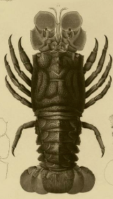
Obviously, this isn't a lobster I know about and it has nothing to do with the contour lines from last week, so it must have appeared at some point in the past. This looks to be some kind of older document.
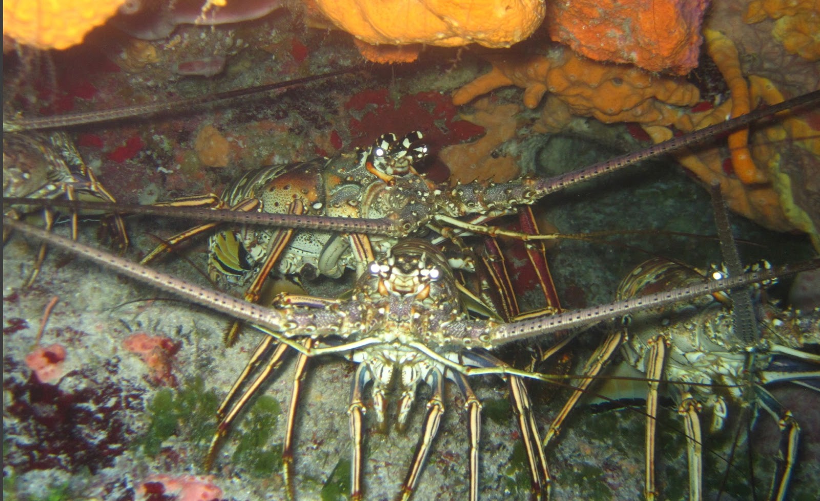
I've got lots of lobster photos from dive trips I've taken (here's an example).
But where did that first lobster image come from?
1. Where is this lobster image from?
2. What's the backstory of the source? (IIRC, it has a kind of crazy story. But I don't remember what it is!)
Can you enlighten me about this lobster image and the tale of the source that goes with it?
As always, let us know how you found the answer!
Search on!
(After last week's Challenge I pre-tested this. I was able to find the answer in less than 5 minutes, although the backstory really is crazy!)
October 22, 2019
Answer: Why are there contour lines there?
Questions come from everywhere...
... in this case, I was just staring out the window and wondering "how did all of this landscape come to be?"
As I said, when I looked into the Sierra foothills just northeast of San Francisco, it seemed as though some giant hand had drawn contour lines on the hills below.
That struck me as very surprising. How could this happen? It made me curious.
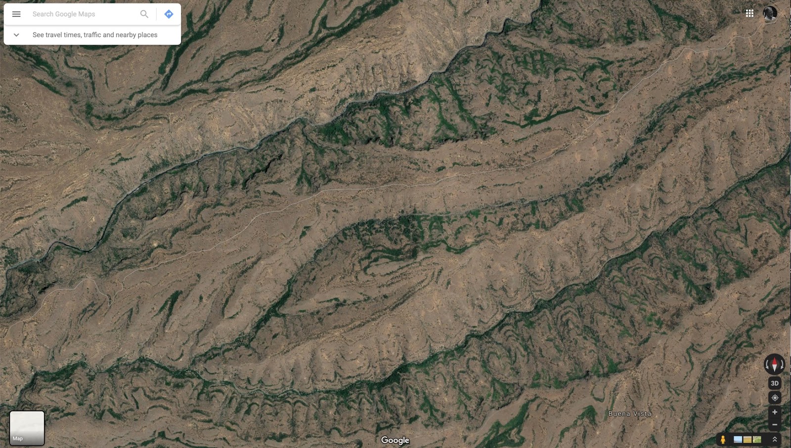
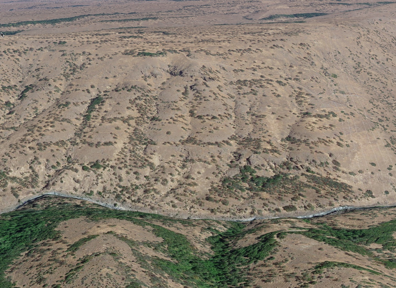
How could I be seeing what looks like contour lines in reality...? To remind you, here's what I saw. The green wavy lines are clearly trees or shrubs that seem to be following some kind of constant edge through the hills.
 Alas, I didn't have my camera handy. This is an image from Google Maps of the place I
saw out the window. It really does look like this!
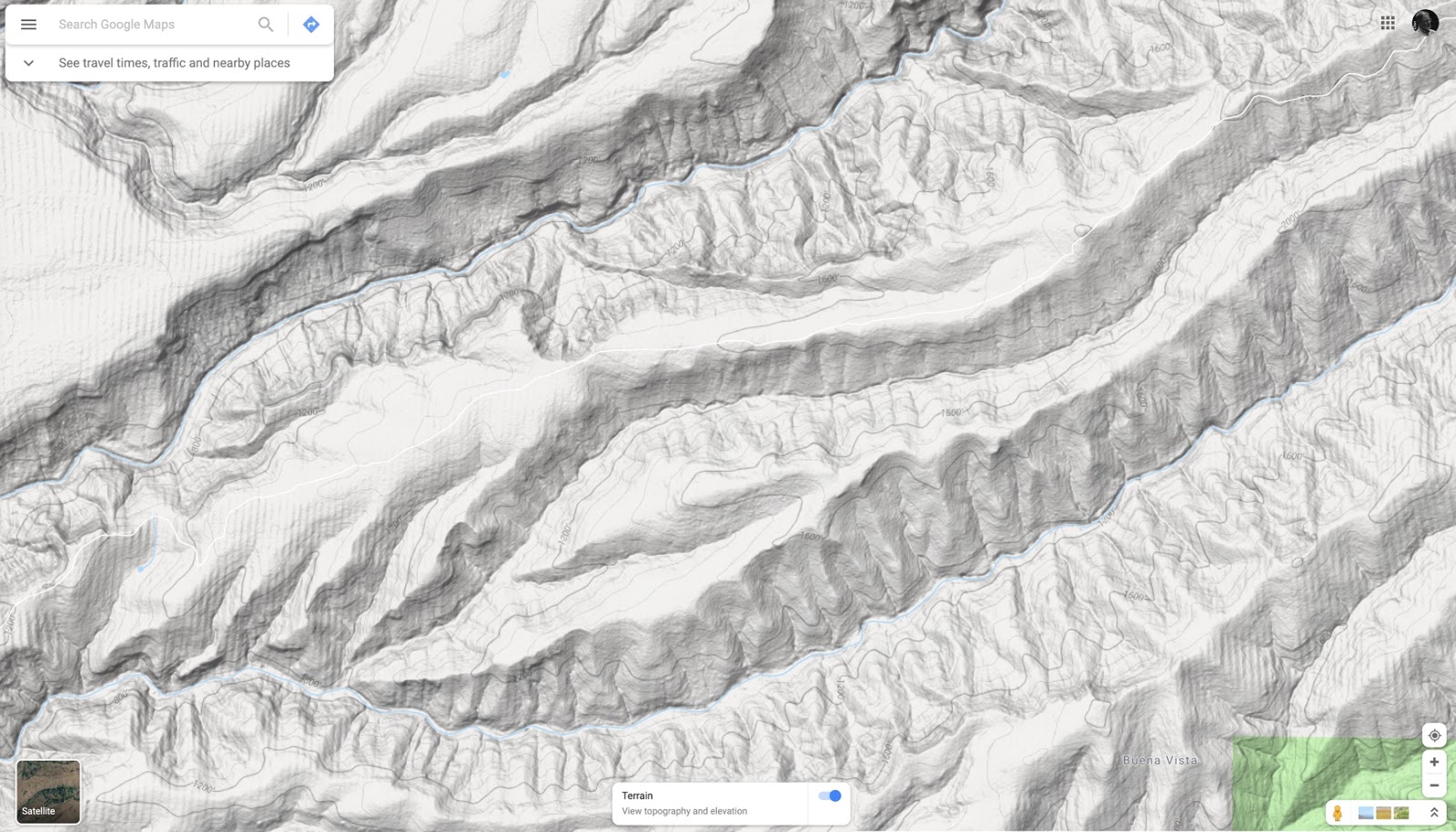
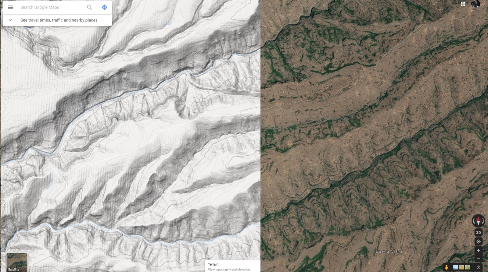
The Terrain view of this location is really interesting.

If you put these side-by-side, they're amazingly similar.

This observation led to our SearchResearch Challenge for the week:
1. What is going on with those naturally green "contour lines" that seem to show up naturally? Why are they growing along the lines of constant elevation? What is going on?
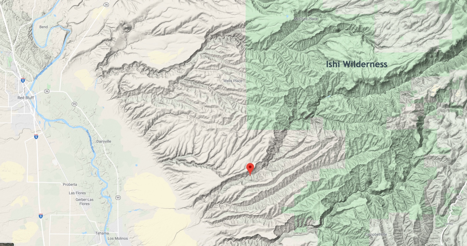
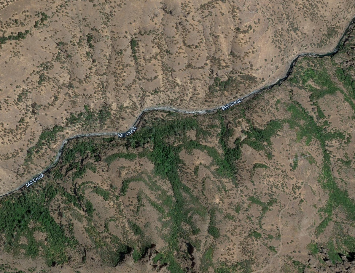
The first thing we need to do is to figure out what this place is called. When you look at it from the air, there aren't any handy labels. Even on the map, the only nearby named things are "Wells Place" and a few creek names, most notably "Mill Creek" (as seen above).
If you zoom out a bit, you'll quickly figure out that this patch of land is halfway between the city of Red Bluff and the Ishi Wilderness (if you keep zooming out, you'll find that this is the southwestern-most part of Lassen Volcanic National Park). And if you zoom IN a bit, you'll find that the Lassen Trail passes through the bottom part of the photo. This is a great overview of the entire area:
 Terrain view of the area between Red Bluff and the Ishi Wilderness
So when I started searching, I used the local terms I know and can see on the map of the area ("Ishi Wilderness" "Lassen Trail" "Mill Creek").
But what am I searching for?
I started with the obvious terms and did searches like:
[ arc-shaped vegetation "Mill Creek" ]
[ crescent plants hillside "Ishi Wilderness" ]
and so on. Trouble was, none of this was working for me. I got lots of hits, but nothing that was useful in any real way. I can SEE these things, but I have no idea what they're called. (Or even, really, what this place is called--I'm looking for something that's between several named entities. An unnamed region is pretty hard to search for!)
But as I was doing this, I realized that the last west of the Ishi Wilderness (that is, in the middle of our search area) is fairly covered in springs. Since springs mean water, and since water leads to green growing things, I wondered if there might not be a connection. Are all of those springs somehow making green things grow in arcs that follow contour lines?
My query was perhaps not obvious, but works quite well:
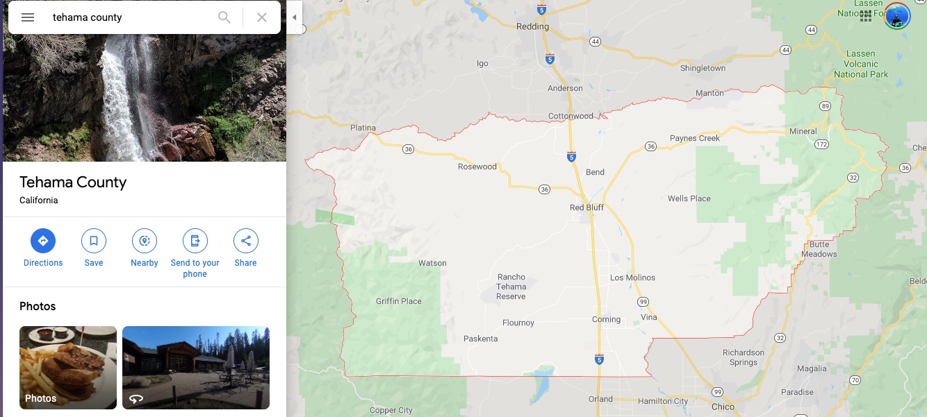
[ springs Tehama county ]
Why Tehama County? I know that in the US, the United State Geological Survey (USGS) often organize their content (e.g. lists of geological features) by county. A quick check of Google maps showed me that the boundary of Tehama County included our interesting location at 40.081801, -121.903088 (link to Google Maps at this location).

See Wells Place just to the right of the city of Red Bluff? That's in the middle of what we're looking for. So, after I did that query, I found a list of Tehama County springs.
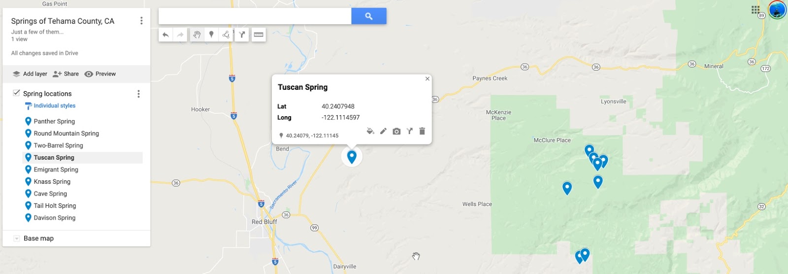
With all of those springs, I made a quick map of some Tehama County springs using Google's My Maps service. (link to my map)

What I found so interesting about this map is that there's a long line of springs uphill from the green contour-following arcs of green. Remember how they seem to follow along the edge of the creeks?
Here's the view of Mill Creek we saw earlier.
 This is a closeup view of Mill Creek (40.090698, -121.907125) with clear arc-shapes
that seem to follow a constant elevation.
Here's another view of the same thing as seen in 3D Google Maps. This is a 3D view of the satellite image from above. (You can make this first clicking on the 3D button in the right-hand side control panel, and then title by holding down the Control-key while moving the mouse up and down to tilt the surface of the Earth.)

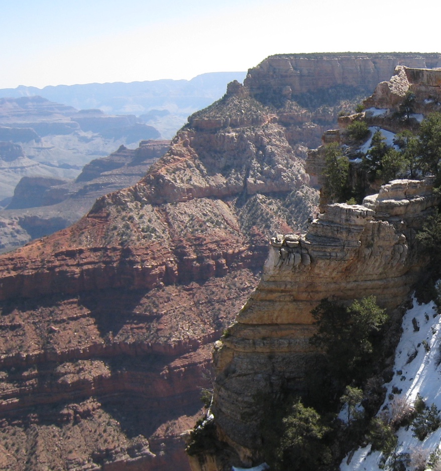
From this perspective, it's clear that those arcs of bushes are really more-or-less horizontal lines. They look a lot like bedding planes that you might see in a canyon cross-cut. Here's an example from the Grand Canyon--bedding planes are the layers of rock you see in the canyon wall.
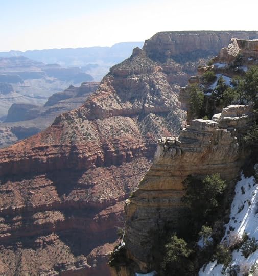 Grand Canyon cross-section showing bedding planes. Note how plants seem to grow
only in certain horizontal sections, and not on others. P/C Dan. It's pretty clear that in canyons like the Grand one, the river cuts a cross section across the bedding planes exposing places where you can see the structure of the rock layers. It's like you've cut a layer cake and can see the different layers, as well as the frosting.

Here's a diagram I drew to make this really clear. Instead of white frosting, here's a valley with the bedding planes / contours shown with red dots.
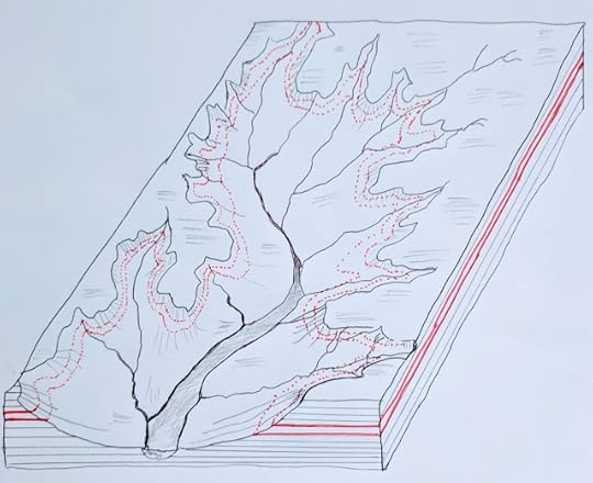 Contour lines along the Mill Creek drainage. (Hand-drawn by Dan.)
Except in this case, it looks like the contour lines are following the bedding planes... as do the green growing plants. What if the bedding planes highlighted in red (on the sides) transport water?
Putting two and two together, we know there are lots of springs in the area, but do they supply water to the bedding planes that then flows to the place where they're exposed in the creek valley?
What do we search for now?
I'll spare you the next few hours of searching. I tried lots of variations of search terms having to do with bedding planes, hydrology, water flows, etc.
But I didn't have much luck until I started looking for versions of this query:
[ geology Tuscan formation ]
[ hydrology Tuscan formation ]
Where did "Tuscan Formation" come from?
I all of my reading on the topic, I finally learned that this whole area (from east of Red Bluff to the Ishi Wilderness) is mostly covered in the "Tuscan Formation" (on the bottom) or the "Riverbank Formation" above.
I first saw that term after I did a search for:
[ geology map Tehama County ]
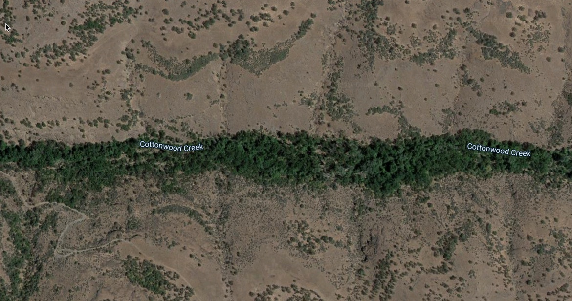
The thing is, once you go down that rabbit-hole, there's a LOT of things to learn about. When you look at a map of the area, they often are extremely complicated--to wit--here's a section of the geological map near Mill Creek (this is of Cottonwood Creek, just a bit to the north of Mill Creek at 40.209742, -121.966270):

Everything labeled with a Q-- (e.g., Qrb) are parts of the Riverbank Formation from different times--they're basically different layers that were laid down many years apart. These are all parallel layers in the complex layer cake of the geography in this area.
If you look carefully, you'll see that this map translates into this image:
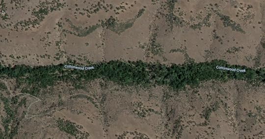
The green line is the watered foliage along the creekside--no surprise there. But the arcs of green follow the Qrl / Qrb lines. That is, the different lines of layer boundaries. The same story is repeated everywhere in this region. When one formation contacts another, there's a dividing line, and water flows along that plane, coming out at the edge of the creek erosion, where plants can absorb it and grow.
So now we have a pretty decent idea about what's going on.
The green arcs really ARE on contour lines. The contour lines are actually the places where two different layers of the formations meet. Groundwater in present in these formations (as we saw in all of the springs uphill from this greenery), and slips between the layers until there's a river cut in the soil, exposing the water along the edge, following the contour lines exactly.
Lessons Learned 1. Sometimes simple questions get very hard. This was hard because I had to learn a lot on the way to be able to ASK a decent question. I learned about the different kinds of springs (toespring, linear seep spring, etc.) because I needed to understand what caused each. This really was a challenge because I had so much to learn!
2. Names matter! Identifying a place name is important, especially for those places that don't really have a name. In this case, the name "Tehama County" included the whole area, but it was incredibly useful as using that name let me find all kinds of resources, even if the area I was searching for was only a piece of the whole.
3. Great information resources can be overwhelming, especially when they're produced for professionals. I'm not a professional geographer (or hydrologist), so when I see these immensely complex and detailed maps (e.g., the USGS Geologic Investigations Series Maps--here's the one for the Tuscan Formation), the trick as a searcher is to NOT be intimidated. Someone understands these things; you can too. You might have to read a bit of background material (I certainly did), but it's not impossible.

Search on!
... in this case, I was just staring out the window and wondering "how did all of this landscape come to be?"
As I said, when I looked into the Sierra foothills just northeast of San Francisco, it seemed as though some giant hand had drawn contour lines on the hills below.
That struck me as very surprising. How could this happen? It made me curious.
How could I be seeing what looks like contour lines in reality...? To remind you, here's what I saw. The green wavy lines are clearly trees or shrubs that seem to be following some kind of constant edge through the hills.
 Alas, I didn't have my camera handy. This is an image from Google Maps of the place I
saw out the window. It really does look like this!
The Terrain view of this location is really interesting.
If you put these side-by-side, they're amazingly similar.
This observation led to our SearchResearch Challenge for the week:
1. What is going on with those naturally green "contour lines" that seem to show up naturally? Why are they growing along the lines of constant elevation? What is going on?
The first thing we need to do is to figure out what this place is called. When you look at it from the air, there aren't any handy labels. Even on the map, the only nearby named things are "Wells Place" and a few creek names, most notably "Mill Creek" (as seen above).
If you zoom out a bit, you'll quickly figure out that this patch of land is halfway between the city of Red Bluff and the Ishi Wilderness (if you keep zooming out, you'll find that this is the southwestern-most part of Lassen Volcanic National Park). And if you zoom IN a bit, you'll find that the Lassen Trail passes through the bottom part of the photo. This is a great overview of the entire area:
 Terrain view of the area between Red Bluff and the Ishi Wilderness
So when I started searching, I used the local terms I know and can see on the map of the area ("Ishi Wilderness" "Lassen Trail" "Mill Creek").
But what am I searching for?
I started with the obvious terms and did searches like:
[ arc-shaped vegetation "Mill Creek" ]
[ crescent plants hillside "Ishi Wilderness" ]
and so on. Trouble was, none of this was working for me. I got lots of hits, but nothing that was useful in any real way. I can SEE these things, but I have no idea what they're called. (Or even, really, what this place is called--I'm looking for something that's between several named entities. An unnamed region is pretty hard to search for!)
But as I was doing this, I realized that the last west of the Ishi Wilderness (that is, in the middle of our search area) is fairly covered in springs. Since springs mean water, and since water leads to green growing things, I wondered if there might not be a connection. Are all of those springs somehow making green things grow in arcs that follow contour lines?
My query was perhaps not obvious, but works quite well:
[ springs Tehama county ]
Why Tehama County? I know that in the US, the United State Geological Survey (USGS) often organize their content (e.g. lists of geological features) by county. A quick check of Google maps showed me that the boundary of Tehama County included our interesting location at 40.081801, -121.903088 (link to Google Maps at this location).
See Wells Place just to the right of the city of Red Bluff? That's in the middle of what we're looking for. So, after I did that query, I found a list of Tehama County springs.
With all of those springs, I made a quick map of some Tehama County springs using Google's My Maps service. (link to my map)
What I found so interesting about this map is that there's a long line of springs uphill from the green contour-following arcs of green. Remember how they seem to follow along the edge of the creeks?
Here's the view of Mill Creek we saw earlier.
 This is a closeup view of Mill Creek (40.090698, -121.907125) with clear arc-shapes
 that seem to follow a constant elevation.
Here's another view of the same thing as seen in 3D Google Maps. This is a 3D view of the satellite image from above. (You can make this first clicking on the 3D button in the right-hand side control panel, and then title by holding down the Control-key while moving the mouse up and down to tilt the surface of the Earth.)
From this perspective, it's clear that those arcs of bushes are really more-or-less horizontal lines. They look a lot like bedding planes that you might see in a canyon cross-cut. Here's an example from the Grand Canyon--bedding planes are the layers of rock you see in the canyon wall.
 Grand Canyon cross-section showing bedding planes. Note how plants seem to grow
 only in certain horizontal sections, and not on others. P/C Dan. It's pretty clear that in canyons like the Grand one, the river cuts a cross section across the bedding planes exposing places where you can see the structure of the rock layers. It's like you've cut a layer cake and can see the different layers, as well as the frosting.

Here's a diagram I drew to make this really clear. Instead of white frosting, here's a valley with the bedding planes / contours shown with red dots.
 Contour lines along the Mill Creek drainage. (Hand-drawn by Dan.)
 Except in this case, it looks like the contour lines are following the bedding planes... as do the green growing plants. What if the bedding planes highlighted in red (on the sides) transport water?
Putting two and two together, we know there are lots of springs in the area, but do they supply water to the bedding planes that then flows to the place where they're exposed in the creek valley?
What do we search for now?
I'll spare you the next few hours of searching. I tried lots of variations of search terms having to do with bedding planes, hydrology, water flows, etc.
But I didn't have much luck until I started looking for versions of this query:
[ geology Tuscan formation ]
[ hydrology Tuscan formation ]
Where did "Tuscan Formation" come from?
I all of my reading on the topic, I finally learned that this whole area (from east of Red Bluff to the Ishi Wilderness) is mostly covered in the "Tuscan Formation" (on the bottom) or the "Riverbank Formation" above.
I first saw that term after I did a search for:
[ geology map Tehama County ]
The thing is, once you go down that rabbit-hole, there's a LOT of things to learn about. When you look at a map of the area, they often are extremely complicated--to wit--here's a section of the geological map near Mill Creek (this is of Cottonwood Creek, just a bit to the north of Mill Creek at 40.209742, -121.966270):
Everything labeled with a Q-- (e.g., Qrb) are parts of the Riverbank Formation from different times--they're basically different layers that were laid down many years apart. These are all parallel layers in the complex layer cake of the geography in this area.
If you look carefully, you'll see that this map translates into this image:
The green line is the watered foliage along the creekside--no surprise there. But the arcs of green follow the Qrl / Qrb lines. That is, the different lines of layer boundaries. The same story is repeated everywhere in this region. When one formation contacts another, there's a dividing line, and water flows along that plane, coming out at the edge of the creek erosion, where plants can absorb it and grow.
So now we have a pretty decent idea about what's going on.
The green arcs really ARE on contour lines. The contour lines are actually the places where two different layers of the formations meet. Groundwater in present in these formations (as we saw in all of the springs uphill from this greenery), and slips between the layers until there's a river cut in the soil, exposing the water along the edge, following the contour lines exactly.
Lessons Learned 1. Sometimes simple questions get very hard. This was hard because I had to learn a lot on the way to be able to ASK a decent question. I learned about the different kinds of springs (toespring, linear seep spring, etc.) because I needed to understand what caused each. This really was a challenge because I had so much to learn!
2. Names matter! Identifying a place name is important, especially for those places that don't really have a name. In this case, the name "Tehama County" included the whole area, but it was incredibly useful as using that name let me find all kinds of resources, even if the area I was searching for was only a piece of the whole.
3. Great information resources can be overwhelming, especially when they're produced for professionals. I'm not a professional geographer (or hydrologist), so when I see these immensely complex and detailed maps (e.g., the USGS Geologic Investigations Series Maps--here's the one for the Tuscan Formation), the trick as a searcher is to NOT be intimidated. Someone understands these things; you can too. You might have to read a bit of background material (I certainly did), but it's not impossible.
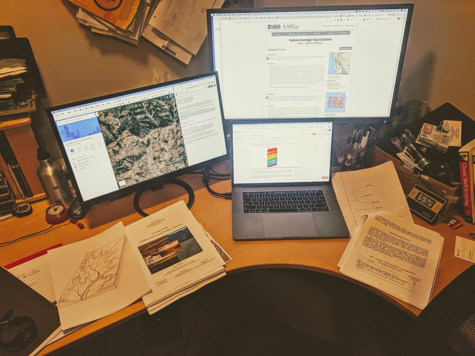
I have to admit that I spent MANY hours on this... probably 10 hours or so. There was a lot of stuff to learn in order to even begin to understand what was going on here.
In fact, I had SO many maps and guidebooks and documents open at once that I finally had to bring in a 3rd monitor! This was my setup in my home office. Luckily, second (and even third) monitors don't cost that much anymore. And it vastly simplified what I was trying to do.
As many other, wiser people have said before me... now that I've started this, I realize how much I really don't know.
But I don't mind the hours spent. I was learning fascinating stuff all the time. It's a kind of graduate education that's difficult to get anywhere else.
Hope you enjoyed this quest as much as I did.
Search on!
October 9, 2019
SearchResearch Challenge (10/9/19): Why are there contour lines here?
As I was flying to Seattle...
... I had the window seat that faced east as we flew north.
Not long after we left SFO, I was staring out the window (because looking out an airplane window when you fly over wilderness is just the best thing you can do), and I saw the most remarkable thing.
It looked like some giant hand had drawn all of the contour lines on the hills below.
What???
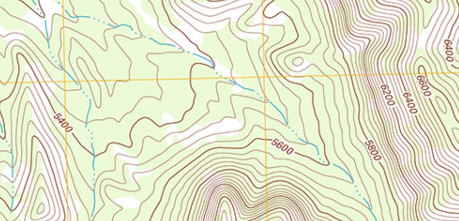
As you know, contour lines on a topographic map mark a constant elevation. For instance, here's a sample of a topo map with contour lines at 5400 feet, 5600 feet, etc. As you can see, there's a steep cliff on the right side of the map, with a more relaxed flat spot on the left.
 Sample topographic map with contour lines.
But the idea of "contour lines" is an artificial way of looking at the land. They're imaginary lines that are drawn to give the reader an idea about what's going on with landform.
So you can imagine my surprise when I looked out my window and saw this, with what looks like contour lines in reality...
Alas, I didn't have my camera handy. This is an image from Google Maps of the place I saw out the window. It really does look like this!
When I got home to my laptop, I searched along the flight path and found the location. (See above.)
Interestingly, if you look at the Terrain view of this location, you'll see something remarkable:
If you put these side-by-side, they're amazingly similar.
The "contour lines" in the satellite photo are clearly lines of trees or bushes or something growing. This amazes me. I thought contour lines were an artificial construct, a visualization device mapmakers would draw on a map to give a sense of shape on an otherwise 2D image.
But how is this possible? Did some maniac cartographer go out there and plant bushes along the contour lines?
This leads to our SearchResearch Challenge for the week:
1. What is going on with those naturally green "contour lines" that seem to show up naturally? Why are they growing along the lines of constant elevation? What is going on?
Any ideas?
In truth, I have no idea what's going on here, and what's more, I don't have a great idea about how to find out! We'll figure this one out together.
One useful piece of information: The center of this map is at 40.081801, -121.903088 (link to Google Maps at this location)
When you figure it out, let us know the answer... AND tell us how you did it. We learn from each other, so also be sure to tell us the paths you pursued that didn't work out.
Search on!
October 3, 2019
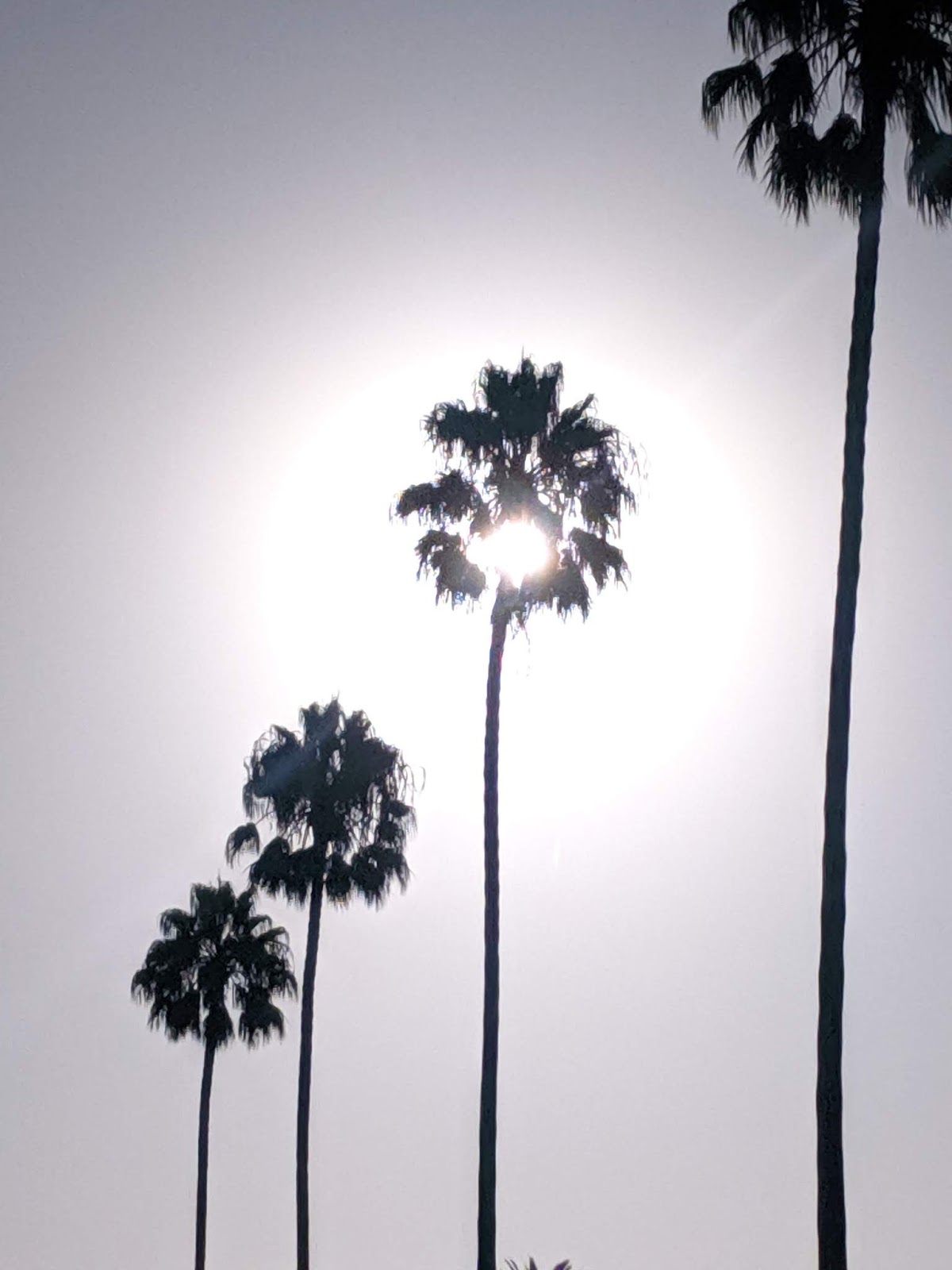
Answer: Why are palm trees so tall?
Palm trees are wonderful, but very strange...
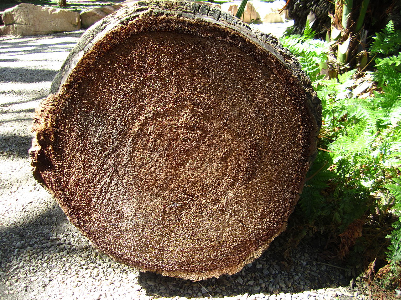
As you might suspect, they're not ordinary trees, but something very, very different.
They're generally super-tall, able to remain standing in hurricane force winds. If you cut one down, you'll see a very strange and wonderful composite structure that looks nothing like an ordinary tree. There are no tree rings, but a bundle of fibers that are key to its extraordinary resilience.
 P/C Wikimedia / Kadeve.
Our Challenge was:
1. Why are palm trees SO tall?
As you know, asking Why Questions can be really difficult and tricky. What's a good answer to a why question?
To get a bit of background, I looked at the Wikipedia entry about palm trees, and quickly ended up on the entry for Arecacae, the latin family name. There I learned that:
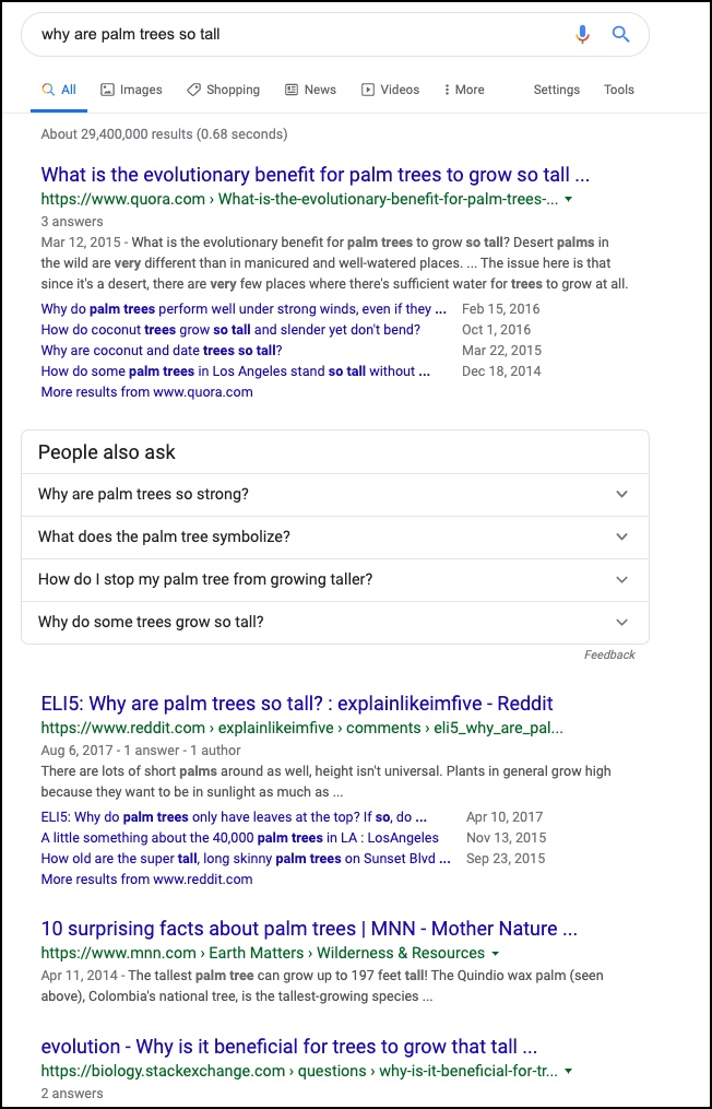
I started this Challenge by doing an obvious search in the form of a question. Note that asking questions like this triggers a special kind of Google search processing--it's not just searching for those terms, but the query is handled much more as a knowledge-based request...
[ why are palm trees so tall ]
The search results are pretty good.
 (Click to see at full size.) The first 4 results are right on topic and give us a diversity of content. Here's what I see and think when I look at these hits.
#1 is a link to a Quora (a well-known question-answering site) discussion with a question about the evolutionary benefit for palms to grow so tall. That's a great approach to answering the why question--understanding the costs and benefits from an evolutionary perspective would be good.
#2 (skipping over the "People also ask" section) links to a reddit "Explain like I'm five" question/answer about "why are palm trees so tall?" The explanation might be simple, but there's almost certainly an interesting discussion there.
#3 is from Mother Nature News, a kind of gee-whiz site with breathless articles like "4 ways tardigrades are nearly indestructible," but might give us some interesting tidbits about tall palms.
#4 links to a StackExchange forum, pointing to the more generic question "Why is it beneficial for trees to grow that tall?" I expect this to be a more general discussion of tree height--perhaps we'll learn something about why trees grow so tall in the first place.
I read the targets of these links and found out that:
* Not all palm trees are tall! (In retrospect, this is obvious--different species of palms have different heights. For instance, the Allagoptera arenaria (Beach palm) is less than 2 meters high. But clearly, we're curious about tall palm in this Challenge.)
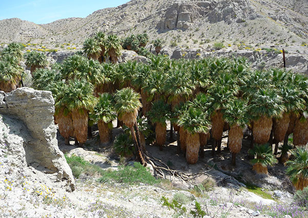
* Palm trees in their wild and natural setting often compete for resources. In the wild, palm forests are often densely packed, requiring the palm trees to do something to grab their own light, water, and nutrients. Growing extremely tall is one solution.
Here are a few images of wild palm tree forests. You can see there's a lot of competition for sun and water.
 Eastern San Diego county, packed into the bottom of a dry ravine.
 A palm forest in Indonesia.
 Even beach locations can be competitive! (Image by Pexels from Pixabay.) (I note that it's a little tricky to find images of palm trees in their wild and unstructured settings. Many palm trees, even dense forests, are often former coconut plantains, which isn't the same.)
Result #2 tells us that palms are often the fastest growing trees (although as with palm tree height, growth rates vary from species to species). So they compete in height, and rate of growth in order to get the resources they need.
Meanwhile, #3 tells us that the tallest palms are the Quindio wax palm ( Ceroxylon quindiuense ), growing up to 60 meters (180 feet), which Wikipedia tells us grows in dense forests in the wild--so height is important there as well.
And #4 asks the more general question, "Why is it beneficial for trees to grow that tall?" Keep in mind that this is a discussion on a StackExchange site that encourages experts to answer and discuss questions. It's heavily moderated, and the quality of the discussions you find there is pretty high.
This particular thread discusses why palms in forests grow so tall, and work through various alternative explanations... but it all comes back a fitness advantage for taller trees to have more sunlight.
An interesting twist... Just for grins (and because I know that shifting media types sometimes gives an insight), I did a search for:
[ palm tree height ]
and looked at Images. It was pretty much what you'd expect. Looked like this in the center of the SERP:

That scatter plot chart in the middle made me think--perhaps there's something interesting here!
Turns out that this chart comes from a scientific paper about the age and height of oil palm trees, Tree height and crown shape as results of competitive games (J. of Theoretical Biology, January 1985) and that made me think about doing a search in Google Scholar.
In Google Scholar:
[ palm tree height ]
led to a bunch of fascinating papers (which time and space prevent me from summarizing, but there's a fun intellectual rathole to explore one day).
But the paper Competition from below for light and nutrients shifts productivity among tropical species
seemed to potentially hold the answer to our question. Turns out that it didn't... exactly... but it DOES make the fascinating observation that
Which kind of captures what we found elsewhere.
Why are palm trees so tall? Answer: Palms compete for light by growing tall and fast. In this case, they overreach the (ordinary) deciduous trees by growing up and through the canopy to reach the pure sunlight above the shade cover of the deciduous trees. But in palm forests they're competing with their peers... where they compete just as hard.
Remarkable.
Search Lessons
This Challenge points out a couple of lessons to learn and take to heart.
1. Looking across a number of different sources is valuable. I know I keep saying this, but as a skilled SRS-er, do NOT lock in on any single result, especially if it confirms your beliefs. A better strategy is to look broadly across a number of results and look for insights that are reported consistently across a number of different authors, different sources, and different perspectives. That's one way to find your way to truth.
2. Try different sources to get a different perspective. Here I did another (but related) search on Google Scholar (after having been prompted by seeing a scientific chart in an image), and found lots of high-quality (but sometimes dense) articles on palm trees and their growth behaviors.
Hope you enjoyed this romp through palm tree botany. As always, there's a LOT more to say about this topic. (If you're interested, a great query is [ varieties of palm trees ] -- they're an amazing group of plants with wildly varying shapes, sizes, and niches. As they say, worth a trip...)
Search on!

As you might suspect, they're not ordinary trees, but something very, very different.
They're generally super-tall, able to remain standing in hurricane force winds. If you cut one down, you'll see a very strange and wonderful composite structure that looks nothing like an ordinary tree. There are no tree rings, but a bundle of fibers that are key to its extraordinary resilience.
 P/C Wikimedia / Kadeve.
 Our Challenge was:
1. Why are palm trees SO tall?
As you know, asking Why Questions can be really difficult and tricky. What's a good answer to a why question?
To get a bit of background, I looked at the Wikipedia entry about palm trees, and quickly ended up on the entry for Arecacae, the latin family name. There I learned that:
The Arecaceae .. can be climbers, shrubs, tree-like or stemless plants.. There are 181 genera with around 2600 species are known, most of them restricted to tropical and subtropical climates. Palms are distinguished by their large, compound, evergreen leaves, known as fronds, arranged at the top of an unbranched stem. However, palms exhibit an enormous diversity in physical characteristics and inhabit nearly every type of habitat within their range, from rainforests to deserts...
I started this Challenge by doing an obvious search in the form of a question. Note that asking questions like this triggers a special kind of Google search processing--it's not just searching for those terms, but the query is handled much more as a knowledge-based request...
[ why are palm trees so tall ]
The search results are pretty good.
 (Click to see at full size.) The first 4 results are right on topic and give us a diversity of content. Here's what I see and think when I look at these hits.
 #1 is a link to a Quora (a well-known question-answering site) discussion with a question about the evolutionary benefit for palms to grow so tall. That's a great approach to answering the why question--understanding the costs and benefits from an evolutionary perspective would be good.
#2 (skipping over the "People also ask" section) links to a reddit "Explain like I'm five" question/answer about "why are palm trees so tall?" The explanation might be simple, but there's almost certainly an interesting discussion there.
#3 is from Mother Nature News, a kind of gee-whiz site with breathless articles like "4 ways tardigrades are nearly indestructible," but might give us some interesting tidbits about tall palms.
#4 links to a StackExchange forum, pointing to the more generic question "Why is it beneficial for trees to grow that tall?" I expect this to be a more general discussion of tree height--perhaps we'll learn something about why trees grow so tall in the first place.
I read the targets of these links and found out that:
* Not all palm trees are tall! (In retrospect, this is obvious--different species of palms have different heights. For instance, the Allagoptera arenaria (Beach palm) is less than 2 meters high. But clearly, we're curious about tall palm in this Challenge.)
* Palm trees in their wild and natural setting often compete for resources. In the wild, palm forests are often densely packed, requiring the palm trees to do something to grab their own light, water, and nutrients. Growing extremely tall is one solution.
Here are a few images of wild palm tree forests. You can see there's a lot of competition for sun and water.
 Eastern San Diego county, packed into the bottom of a dry ravine.
 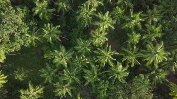 A palm forest in Indonesia.
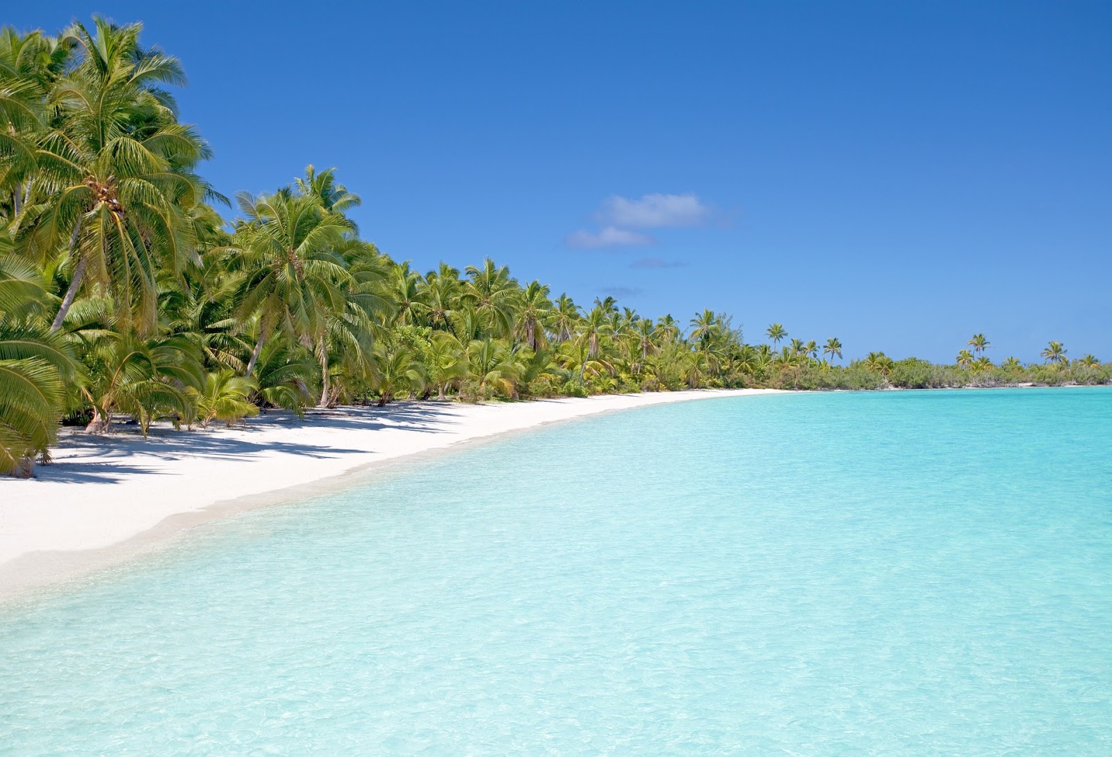 Even beach locations can be competitive! (Image by Pexels from Pixabay.) (I note that it's a little tricky to find images of palm trees in their wild and unstructured settings. Many palm trees, even dense forests, are often former coconut plantains, which isn't the same.)
 Result #2 tells us that palms are often the fastest growing trees (although as with palm tree height, growth rates vary from species to species). So they compete in height, and rate of growth in order to get the resources they need.
Meanwhile, #3 tells us that the tallest palms are the Quindio wax palm ( Ceroxylon quindiuense ), growing up to 60 meters (180 feet), which Wikipedia tells us grows in dense forests in the wild--so height is important there as well.
And #4 asks the more general question, "Why is it beneficial for trees to grow that tall?" Keep in mind that this is a discussion on a StackExchange site that encourages experts to answer and discuss questions. It's heavily moderated, and the quality of the discussions you find there is pretty high.
This particular thread discusses why palms in forests grow so tall, and work through various alternative explanations... but it all comes back a fitness advantage for taller trees to have more sunlight.
An interesting twist... Just for grins (and because I know that shifting media types sometimes gives an insight), I did a search for:
[ palm tree height ]
and looked at Images. It was pretty much what you'd expect. Looked like this in the center of the SERP:

That scatter plot chart in the middle made me think--perhaps there's something interesting here!
Turns out that this chart comes from a scientific paper about the age and height of oil palm trees, Tree height and crown shape as results of competitive games (J. of Theoretical Biology, January 1985) and that made me think about doing a search in Google Scholar.
In Google Scholar:
[ palm tree height ]
led to a bunch of fascinating papers (which time and space prevent me from summarizing, but there's a fun intellectual rathole to explore one day).
But the paper Competition from below for light and nutrients shifts productivity among tropical species
seemed to potentially hold the answer to our question. Turns out that it didn't... exactly... but it DOES make the fascinating observation that
"...In 2 cases the novel competitive mechanism responsible for the shift was reduction in crown volume, and therefore light-capturing capability, of overtopping deciduous trees by intrusive growth from below a palm."
Which kind of captures what we found elsewhere.
Why are palm trees so tall? Answer: Palms compete for light by growing tall and fast. In this case, they overreach the (ordinary) deciduous trees by growing up and through the canopy to reach the pure sunlight above the shade cover of the deciduous trees. But in palm forests they're competing with their peers... where they compete just as hard.
Remarkable.
Search Lessons
This Challenge points out a couple of lessons to learn and take to heart.
1. Looking across a number of different sources is valuable. I know I keep saying this, but as a skilled SRS-er, do NOT lock in on any single result, especially if it confirms your beliefs. A better strategy is to look broadly across a number of results and look for insights that are reported consistently across a number of different authors, different sources, and different perspectives. That's one way to find your way to truth.
2. Try different sources to get a different perspective. Here I did another (but related) search on Google Scholar (after having been prompted by seeing a scientific chart in an image), and found lots of high-quality (but sometimes dense) articles on palm trees and their growth behaviors.
Hope you enjoyed this romp through palm tree botany. As always, there's a LOT more to say about this topic. (If you're interested, a great query is [ varieties of palm trees ] -- they're an amazing group of plants with wildly varying shapes, sizes, and niches. As they say, worth a trip...)
Search on!
October 2, 2019
Slight delay... I'm giving a talk at a librarian's conference today!
Strangely,
... palm trees line the Embarcadero, the grand boulevard that wraps around the top of San Francisco.
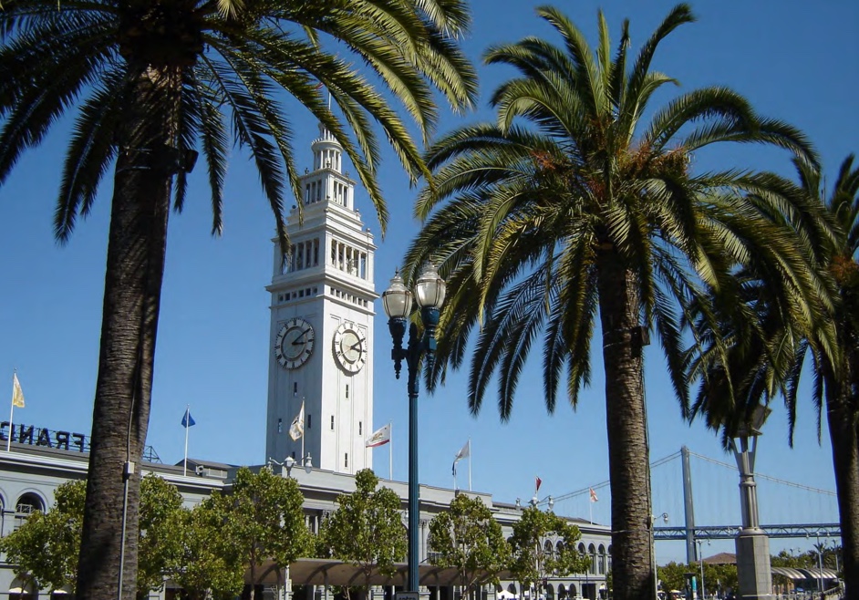
I'm not sure how they manage it here--it's cool and often foggy, nothing like the deserts or tropical isles where palms are native.
But they do survive. Barely.
I'm here in San Francisco today to give a talk entitled The Nature of Literacy and Learning in the Future. You can see the program for the Pacific Library Partnership conference here.
You won't be surprised when I say that learning how to do effective research is a critical skill.
So I'll be at the San Francisco Public Library today, enjoying chatting with librarians and researchers.
And as a side-effect, I'll write up my ruminations on palm trees tomorrow.
Search on!
September 25, 2019
SearchResearch Challenge (9/25/19): Why are palm trees so tall?
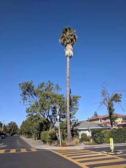
As I bicycled around town...
... I saw a palm tree that stood out from my local urban landscape. It was easily 100 feet tall, and REALLY rose well above the line of buildings and other urban trees.
I thought to myself, "now that is one weird tree."
And I grew up in Los Angeles, where row upon row of palm-lined streets really are commonplace. This is Windsor Blvd--just another LA street.
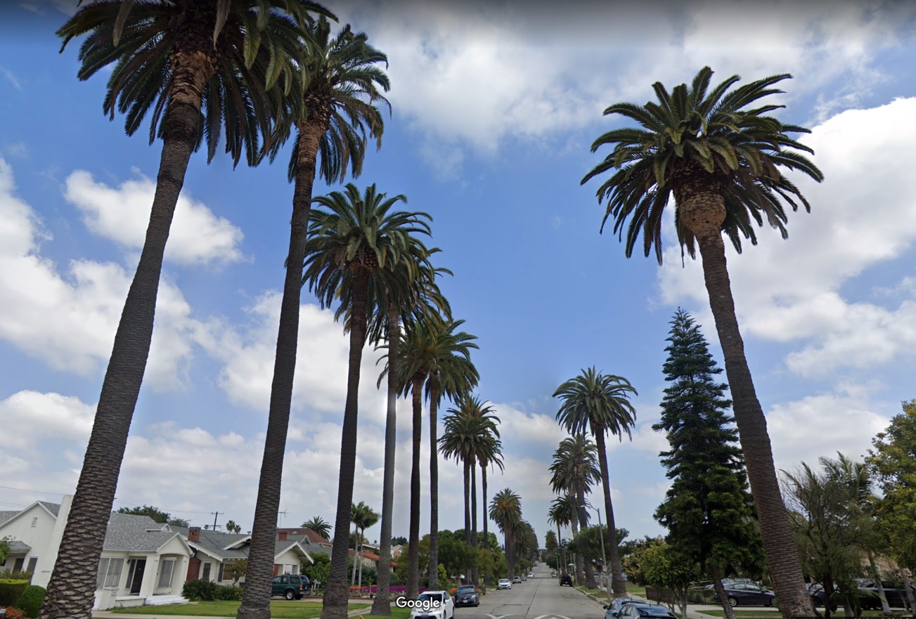
Then it occurred to me: WHY is it like that? Why are they so ridiculously tall and skinny?
We've discussed palm trees before in SRS (back in May, 2015 when we asked "Victorians and palms. A thing?"). Back then we decided that yes, it was a thing for Victorian era landscapers to plunk palm trees down everywhere. As we found "Victorians were mad about palms."
But as interesting as that is, it doesn't answer our Challenge today:
1. Why are palm trees SO tall?
It doesn't seem to make sense.
Or does it?
Can you figure out why this tree has managed to do so well over the years? And why does it have such a strange aspect ratio??
Once you find out, let us know, and tell us HOW you figured it out!
Search on!
P.S. You'll note that I did this post in a LARGE font. Do you like it? Hate it? (I did it because I noticed that the posts are hard to read on mobile devices. So this is a small experiment to see what might work better. Your opinion?)
September 19, 2019
"The Joy of Search" is in bookstores now!
¡Flash!
The Joy of Search is now available in your local bookstore!
I stopped by my local bookstore (Kepler's in Menlo Park, CA) and was just browsing new releases on the "Big Ideas" table. Lo and behold... there is was!

Funny thing... it's next to "How to Raise Successful People" by Esther Wojcicki, who just happened to have written a blurb for the book jacket, and beneath "Trillion Dollar Coach" written by Eric Schmidt (who also wrote a blurb!), Jonathan Rosenburg, and Alan Eagle (who helped me out with the book's production). It's nice to be near friends!
Then, the book to the right is Christof Koch's book about the nature of consciousness.
So the book is in great company. This sounds silly, but having your book get good placement in the bookstore leads to more sales, which in our case leads to better searching!

Happy Happy, Joy Joy! It's finally really out there for everyone.
Search on!!
September 18, 2019
Answer: What's the relationship between these two fish?
I don't mean to have so many ichthyological Challenges,
it's just that I can't help myself...
When I go diving, the world is just SO different than the dry world on land. That vast difference always makes me wonder what's going on.
In this case, I noticed this very clear connection between these two fish and wondered to myself: What's going on here??
This is the kind of moment that makes for an interesting SRS Challenge--that moment of wondering--that sudden sense of slight bewilderment and amazement. That, my friends, is the basis of all research. Why is this like that ??
Let's get to it.
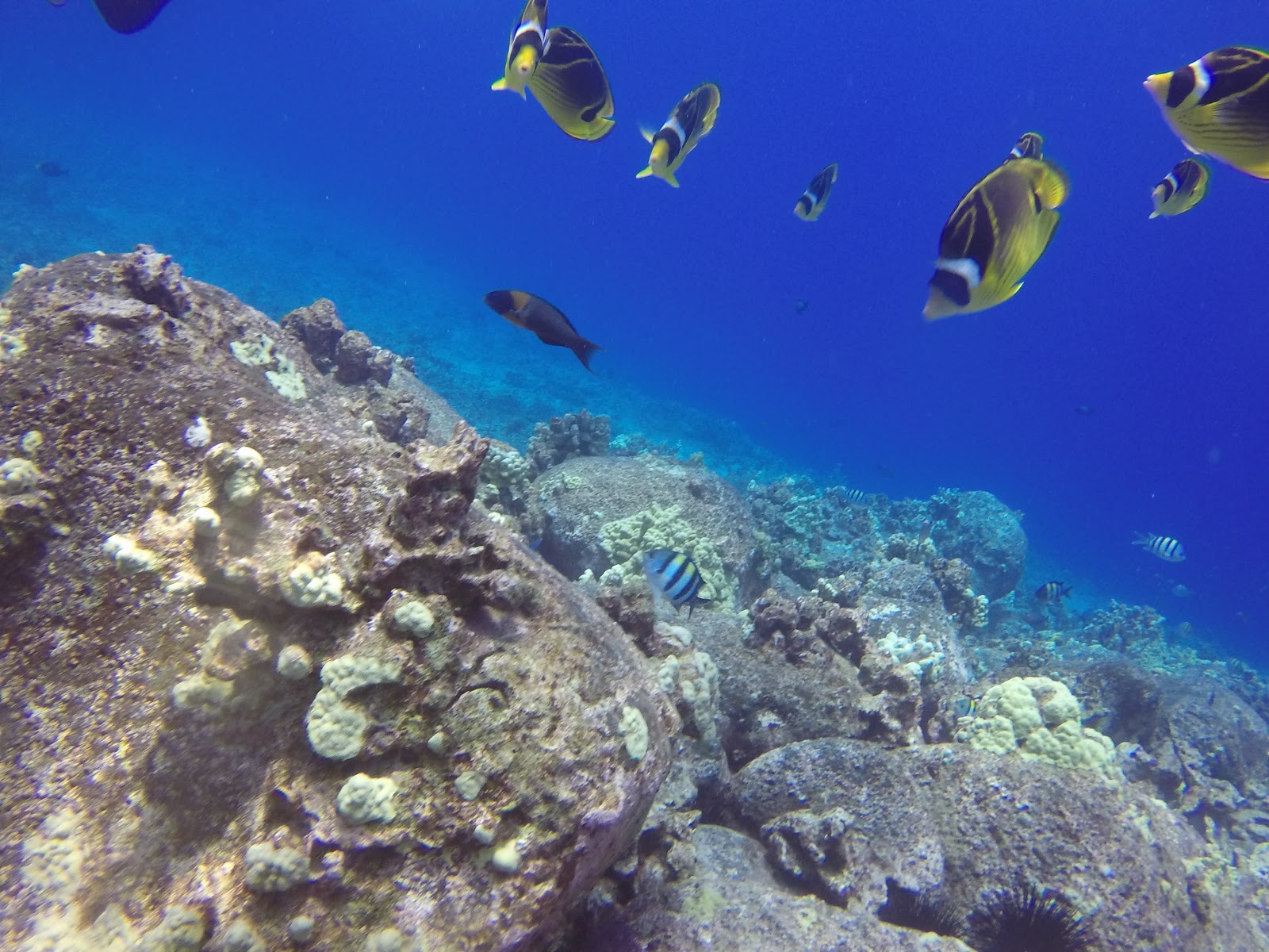
1. Here's Fish #1. They hang out in rocky crevices, alway near a kind of purple glaze on part of the rocks. What kind of fish is this?? (For reference, it's about 4 inches long.)

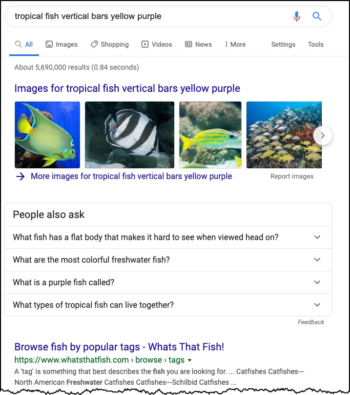
Today we're onto fish identification. We need to identify the fish above and the fish below. Using the information we have at hand, we KNOW it's a tropical fish (I said as much in the Challenge) and that it's somehow associated with purple.... something. (I called it a "haze." That's about as useless a term as you might want. Clearly, I don't know what the purple stuff is.) I thought I'd try doing it with just a simple query, then searching through some images to get a good match. My query was a simple description of what I see in the photo: [ tropical fish vertical bars yellow purple ] This is what I got... and it worries me. Looks like there are LOTS of fish with vertical bars...
I switched immediately to Images and found that the results are much more promising. Yes, there are lots of fish with vertical bars, but the images page put my mind at ease. The first fish in the results looks very close to what I seek:

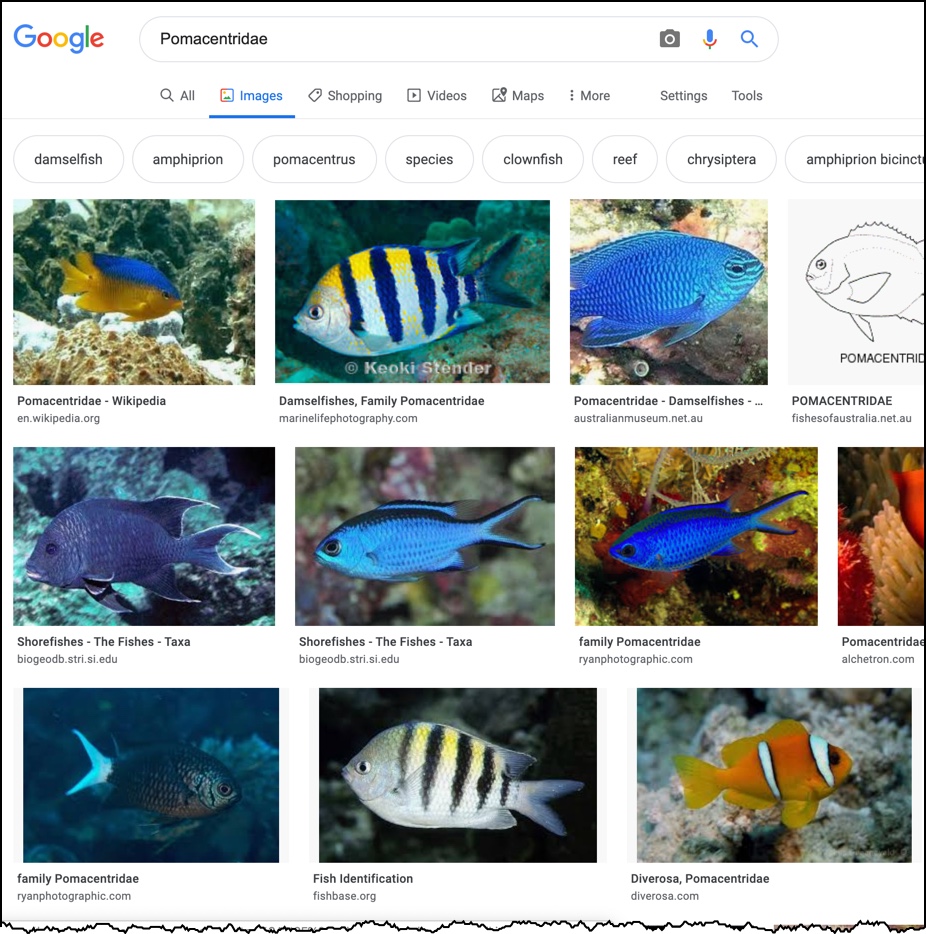
That first result (upper left corner) tells me that this is an Abudefduf saxatilis, which is a kind of Damselfish or Clownfish in the family Pomacentridae. This is important information because LOTS of related fish can look very similar. (In fact, fish appearance can vary hugely over the course of their lives. But that's another story.) So naturally I looked up Pomacentridae to see if there was any useful information there. I found the Wikipedia article helpful, but not definitive. I learned that these fish are found on or near coral reefs in the Indo-West Pacific (from East Africa to Polynesia). The area from the Philippines to Australia hosts the greatest concentration of species, but that there are also significant populations in the Atlantic and the Mediterranean. I thought that Images for Pomacentridae might be interesting, so I looked at that page. What do you know? Right there, second image--an exact match. But notice--that's NOT an Abudefduf saxatilis, it's an Abudefduf vaigiensis! (Also known as the "Indo-Pacific Sargent Major.")
Notice that there's another fish that looks pretty similar (the striped fish in the bottom row). What's the difference? Note the difference in the color of the stripes and the yellow across the top. As you know, photos can be hard to trust, especially with underwater photos. So, what can we do to be more precise about this fish identification? Here I put the two major striped varieties of Sargent Majors side-by-side (Abudefduf vaigiensis and A. saxatilis).
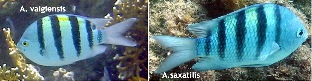
Both have 5 vertical bars, both have a yellow patch on the back--they're surprisingly similar. I did a search for: [ Abudefduf identification ] and found fairly detailed descriptions in FishBase.se (A. saxatilis and A. vaigiensis ), but the written descriptions are nearly identical. The biggest difference is their respective ranges. So perhaps we have to identify the other fish in the next image, figure out its range, and see where they overlap.
 So...
So... 2. What kind of fish is Fish 2? (It's about 7 - 8 inches in length.)
This time I went with trusty Yandex search on a cropped image. I took the above image and cropped it down to a single individual fish, like this:
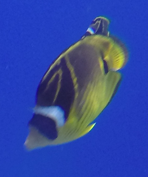
Dropped that into Yandex reverse-image search and got these great results:

From this page, it's easy to figure out that this is a Raccoon butterflyfish ( Chaetodon lunula ), whose distribution is--surprise surprise!-- in the Indo-Pacific!
This strongly suggests that the Sargent Major seen above is actually an Abudefduf vaigiensis (aka Indo-Pacific Sargent Major).
Now we've cleared THAT up.
3. What's going on when Fish 2 quickly swim into the crevices with purple glaze?
As you can see in the first picture, there really IS a purple haze (or glaze) on the rock surfaces near the Indo-Pacific Sargent Major. But since I'm not sure what the glaze (or haze) is, I did a query like this:
[ indo-pacific sargent major purple ]
This way I'll get everything with purple something and the Indo-Pacific sargent major. Note that I could also have done the more specific:
[ Abudefduf vaigiensis purple ]
and gotten equally good results.
With either query, one quickly finds that it's the MALE Sargent Majors that are protecting purple eggs. They also fan their tails near the eggs to aerate them.
To find the connection between the Sargent Majors and the Raccoon butterflyfish, just search for them both:
[ Sargent Major Raccoon butterflyfish ]
(Or use their scientific names--in this case it gives more-or-less the same results.)
You'll quickly find articles where both of these fish are named--and learn that Raccoon butterflyfish (along with several other kinds of fish) are opportunistic poachers of Sargent Major eggs... those purple glaze patches you see in image 1 above. That's why the Sargent Majors defend their nests with such diligence.
Interestingly, if a diver manages to scare the Sargent Major away from its nest, other fish will swoop in to get what eggs they can. As a consequence, Raccoon butterflyfish will sometimes follow divers around, hoping to pick up some eggs when the giant human scares the little Sargent Major away for a few seconds.
4. Where is Dan now??
Based on what we see in these two fish, all we know definitively is that I'm somewhere in the Indo-Pacific. But look carefully in the background of the second image and you'll see this guy:

A quick search on Images will tell you that this is the Saddle Wrasse (Thalassoma duperrey). Since we've already used Fishbase.se as a reputable source of fishy data, you can quick get lots of info about this wrasse. In particular, if you look at the range maps for each of these fish, you'll see that while all three are Indo-Pacific in range, the Saddle Wrasse is only in Hawai'i.
And that, in fact, is where I was. (Diving off the Kona coast of the Big Island, to be precise.)

And, while there, I also did a fantastic night dive with the Manta rays. (Here's a link to the YouTube video I made from that dive.)
SearchResearch Lessons
There are several here...
1. Animal / plant / fish identification can be very tricky--especially with fish that are variable in appearance. It such cases you have to pull together multiple sources of information (e.g. range and distribution information) in order to pin things down.
2. Sometimes you need to look in the background for additional clues. Here we had to not only identify the two fish I asked about, but also a 3rd fish in the background in order to zero in on the location. (The saddle wrasse let us pinpoint where I was diving.)
3. Simple text searches can be useful in describing your visual target. As you saw, my first approach in description worked out pretty well. ("vertical bars" etc.) From there I was able to gather enough information to pull together a decent set of results.
This took me much longer to write up than to do... but I hope you enjoyed the results... and the journey.
I certainly did!
Search on!
September 11, 2019
SearchResearch Challenge (09/10/19): What's the relationship between these two fish?
I'm scuba diving again ...
... I know--not a big surprise. But this time I'm diving with friends on a tropical island, taking a few underwater photos and finding remarkable things that require a bit of research when I get topside.
In today's Challenge, I'm diving somewhere in the tropics, and today I saw these two fish.
What's odd, though, is that these fish seem to have some kind of strange relationship that I can't quite figure out.
Can you?
(This is a fun fishy SearchResearch Challenge. It will test your query formation skills and your ability to combine two ideas and find their relationship.)
1. Here's Fish #1. They hang out in rocky crevices, alway near a kind of purple glaze on part of the rocks. What kind of fish is this?? (For reference, it's about 4 inches long.)
This is a bit of an unusual shot. Normally there would be hundreds of these fish swimming all around.
However, whenever I'd see a fish like this, there would ALWAYS be fish like this nearby:
(You see several examples of Fish1 in the backwater. Fish 2 are the larger ones in the top of the photo.)
So...
2. What kind of fish is Fish 2? (It's about 7 - 8 inches in length.)
... and the REAL question... what is the relationship between Fish 1 and Fish 2?
Usually Fish 1 chases Fish 2 out of the crevices, but every so often Fish 2 would zoom into the crevices for a few seconds before darting out again.
3. What's going on when Fish 2 quickly swim into the crevices with purple glaze?
4. Where is Dan now??
Can you answer these questions?
Be sure to let us know HOW you find the answer to the Challenge.
Search on!


