
A Heatmap of All My Cycling In and Around Kyoto
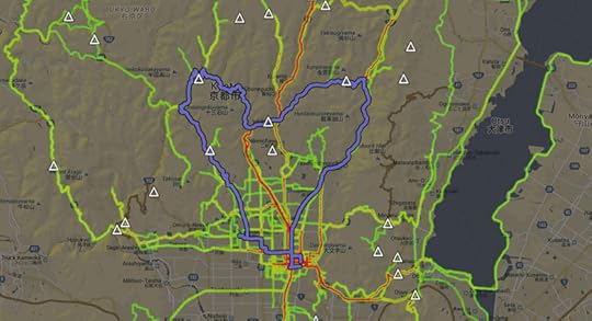
One “Kyoto Heart Loop” Ride
highlighted among all the cycling I've done this year
私のサイクリング経験の「ヒートマップ」。よく行く所は赤くなる。
I built a “heatmap” showing all the places I've ridden my bicycle since
getting into cycling earlier this year. I thought it might be interesting
for visitors researching rides they might want to try.
It's here: “Heatmap of Jeffrey's Cycling in Kyoto”.
At the moment it includes data on 76 rides, with areas of yellow and red
being more-often visited roads.
Clicking anywhere I've ridden brings up a list of rides that passed the area...
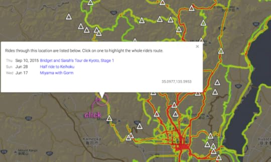
In the example above, I'd ridden the clicked-on road three times. Clicking then on the most-recent ride name
highlights the whole ride on the map, and info about the ride shows up at the top:

The info at the top includes a link for the activity at Strava, and any
related blog posts or Facebook photo albums.
Mountain passes are marked with a triangle icon; clicking on one brings up its name and elevation...

You can turn off the mountain-pass display by clicking on the triangle icon in the upper-right corner of the page.
I don't know whether this will actually be interesting for anyone
besides me, but since I made it, I thought I'd share it.
(Thanks to Google for providing the tools that do all the hard work of mapping and display.)


Jeffrey E.F. Friedl's Blog

- Jeffrey E.F. Friedl's profile
- 13 followers

