
DICE-y Digitization
The following post is by Elizabeth Pieri, one of 36 college students who participated in the Library’s Junior Fellow Summer Intern Program. She’s in her fourth year at Rochester Institute of Technology, as a motion picture science major. Because her program focuses on the fundamental imaging technologies used in the motion picture industry, she was able to apply her knowledge of imaging analysis and programming to her Library project. Pieri was also able to attend meetings and tours that pertained to the film and motion picture industry, which she found beneficial because of her interests within her field of study.
What do you think this map really looks like? Pick one! (answer below)


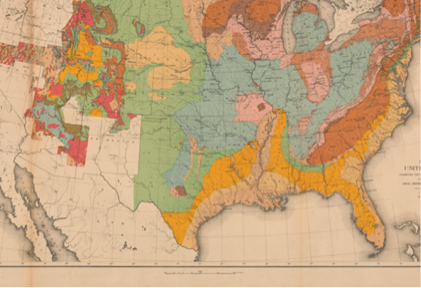

Only one of these is accurate to the original, but any one of these could be. How do we know which one is right?
The Library of Congress has pioneered the effort to develop a system to measure the quality of digital imaging, including the analysis of color quality. Starting in 2008, the Library began development of the Digital Image Conformance Evaluation Program (DICE). This program has become the reference tool used by cultural heritage digitization centers worldwide and has helped to improve the quality of digitization of our cultural treasures.
My project involves helping Lei He, a digital imaging specialist in the Library, develop an open source version of this system that can be freely distributed to cultural heritage institutions worldwide. Specifically, I am writing the code and building the interface using MatLab, a scientific programming environment that I learned at Rochester Institute of Technology.

Correct image of the map. The Geography and Map Division scans every object with an object level target.
Color accuracy in digitization is critically important but really difficult to achieve. So which map is right? We measure the color values in the DICE target that is imaged with the map and evaluate the data in DICE. You can see the target under the map in the correct image here on the right.
DICE reports the accuracy of the reproduction, displaying measurements of both luminance (brightness) and the color references on the target.

Luminance

Color difference
To ensure quality images, DICE is used very frequently across the Library. It has been used in the process of digitizing the Americana Vault collection, the Rosa Parks collection, the safety negatives of the Farm Security Administration and the field projects of the American Folklife Center, just to name a few.
The Library’s goal is to release this tool in January of 2016 with the next Federal Agencies Digitization Guidelines Inititiave (FADGI) still image digitization guidelines update. (See the guidelines here.) Combined with the new imaging guidelines, the tool will help improve digitization worldwide. Who would have guessed that the Library of Congress is on the forefront of digital imaging? Many people don’t realize the huge scope of projects the Library has taken on and what a service they provide to the public.


Library of Congress's Blog

- Library of Congress's profile
- 74 followers

