
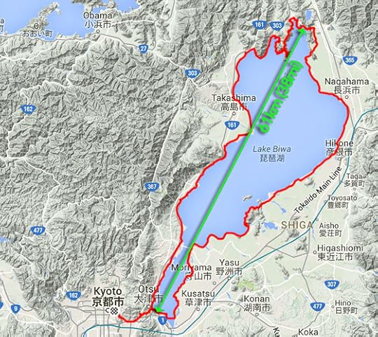
Bicycle Ride Around Japan’s Largest Lake, Part 1
Wednesday's Outing
230km (143 miles) by bicycle
I had a nice
bicycle outing on Wednesday with friends, riding around Lake Biwa (the largest
lake in Japan). I ended up covering about 230km (143 miles).
Despite being almost twice as long as my previously-longest
ride, it was much easier for two reasons: it was mostly flat (just
1,600m / 5,250' of vertical climb over the 230km, compared to, for example,
2,500m / 8,300' over 99km), and I was much better at
keeping myself filled with calories. I'm starting to discover that it's
easier to ride the bicycle when you have energy.
Panasonic LX100 at an effective 24mm — 1/200 sec, f/5, ISO 200 —
map & image data — nearby photos
Gathering
in front of Sanjo Starbucks, Kyoto Japan
Gorm Kipperberg,
Kumiko Naka,
and Joshua Levine
5:38 AM ( 12 min) - 1.3 km (0.8 miles)
To explain the last line of the caption, the photo was taken at 5:38am,
12 minutes (and 1.3km) after I left my house.
Most photos are denoted this way to help give a
sense of travel. The elapsed time
(“ 12 min” in
the example above) is just how long since I left
the house, so it includes both travel time and pauses (traffic, chatting, snacks, sightseeing, etc.)
I'm not one to get up that early, much less be out and about already
that early, but we knew we had a long day ahead of us, so the meeting time
was set for 5:30am. As ridiculously early as that is, the sun is up even
earlier... it rose at 4:42 that day. The sun rises early in the Land of the
Rising Sun. (I didn't realize until checking the data while writing this
post, but the sunrise at 4:42 that day is the earliest of the year.)
Anyway, before we could go around the lake, we had to get
to the lake, so we got going and headed over the small mountains in
between. This involved two little climbs totaling 200m (650') of elevation
gain. We arrived at the lake in great spirits
ready to go.
Panasonic LX100 at an effective 24mm — 1/2500 sec, f/4, ISO 200 —
map & image data — nearby photos
Arriving at Lake Biwa
6:22 AM ( 55 min) - 13 km (8.1 miles)
taken while cycling at 14 kph (8 mph)
The cyclist at the left in the photo above is not part of our group. He looks to be setting up his bike for a picture, likely before he starts his
own trip around the lake.
Panasonic LX100 at an effective 44mm — 1/4000 sec, f/4, ISO 200 —
map & image data — nearby photos
Photo on the Go
6:23 AM ( 56 min) - 13 km (8.2 miles)
taken while cycling at 25 kph (15 mph)
Panasonic LX100 at an effective 24mm — 1/1000 sec, f/4, ISO 200 —
map & image data — nearby photos
My Attempt at a “Selfie”
6:23 AM ( 57 min) - 14 km (8.4 miles)
taken while cycling at 18 kph (11 mph)
Panasonic LX100 at an effective 75mm — 1/12800 sec, f/5.6, ISO 200 —
map & image data — nearby photos
Dawn at the Lake
6:26 AM ( 59 min) - 15 km (9.1 miles)
(it wasn't really dawn, the sun having been up for almost two hours, but it still felt that way to me.)
We soon stopped at a picturesque spot to take some photos before starting the
circumnavigation loop in earnest...
Panasonic LX100 at an effective 56mm — 1/2500 sec, f/5.6, ISO 200 —
map & image data — nearby photos
Memorial Photo
6:31 AM ( 1h 4m) - 16 km (9.9 miles)
Panasonic LX100 at an effective 75mm — 1/10000 sec, f/5.6, ISO 200 —
map & image data — nearby photos
Misty Morning
Panasonic LX100 at an effective 67mm — 1/3200 sec, f/2.8, ISO 200 —
map & image data — nearby photos
Shooting the Breeze
This was the first attempt at a trip around Lake Biwa for all of us but
Joshua, who has done it many times, and his laid-back demenor rubbed off, and we all felt at ease.
Panasonic LX100 at an effective 32mm — 1/6400 sec, f/2.2, ISO 200 —
map & image data — nearby photos
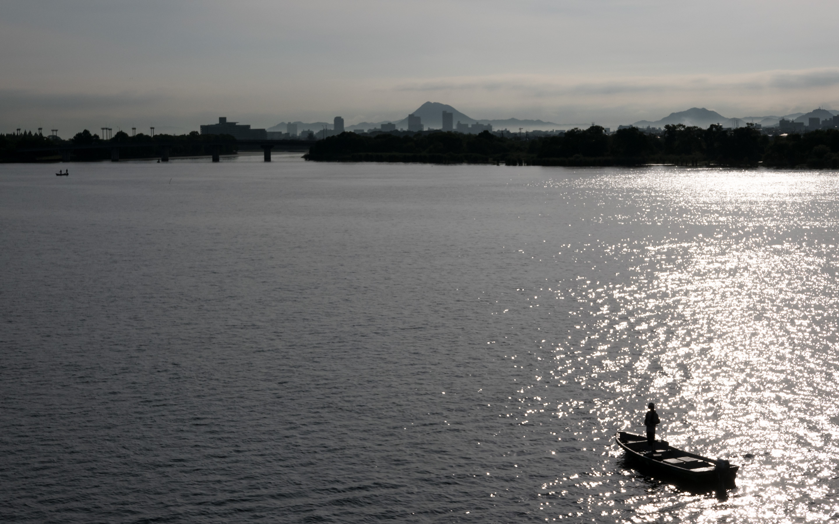
Bottom of the Lake
6:35 AM ( 1h 8m) - 16 km (10.0 miles)
taken while cycling at 19 kph (12 mph)
The huge lake narrows in the south to eventually become a river. The bridge seen in the background of the photo above cuts across the bottom of
the lake/river, so our route takes us over it to the eastern side of the lake.
The view from the bridge was pretty...
Panasonic LX100 at an effective 65mm — 1/2000 sec, f/8, ISO 200 —
map & image data — nearby photos
View from the Bridge
6:39 AM ( 1h 13m) - 18 km (10.9 miles)
Desktop-Background Versions
1280×800 · 1680×1050 · 1920×1200 · 2560×1600 · 2880×1800
Panasonic LX100 at an effective 24mm — 1/250 sec, f/5.6, ISO 200 —
map & image data — nearby photos
Waiting At The Trail Start
6:41 AM ( 1h 14m) - 18 km (11.4 miles)
Immediately at the end of the bridge one can get onto a walking/cycling
trail that runs up much of the eastern side of the lake. I had stopped for
a minute to take photos, so they waited for me there. Then it was time to
being the ride in earnest...
Panasonic LX100 at an effective 75mm — 1/200 sec, f/5.6, ISO 200 —
map & image data — nearby photos
6:43 AM ( 1h 16m) - 19 km (11.7 miles)
taken while cycling at 23 kph (14 mph)
Panasonic LX100 at an effective 32mm — 1/320 sec, f/5.6, ISO 200 —
map & image data — nearby photos
Many Facets of the Shore Area
7:06 AM ( 1h 39m) - 29 km (18.2 miles)
taken while cycling at 24 kph (15 mph)
Panasonic LX100 at an effective 24mm — 1/125 sec, f/7.1, ISO 200 —
map & image data — nearby photos
Biwako Rainbow Bridge
7:17 AM ( 1h 50m) - 35 km (21.5 miles)
taken while cycling at 26 kph (16 mph)
Before the lake really opens up, there's one area where it narrows to
less than a mile across, and so
there's a big bridge over it at that point.
Joshua wouldn't have time to do the whole trip around, so we stopped at the
bridge for snacks before he left us with parting advice on the upcoming
route, then took the bridge heading back toward Kyoto.
Panasonic LX100 at an effective 33mm — 1/200 sec, f/5.6, ISO 200 —
map & image data — nearby photos
Pause that Refreshes
snacks and stretches
7:23 AM ( 1h 57m) - 35 km (21.8 miles)
Panasonic LX100 at an effective 24mm — 1/125 sec, f/5, ISO 200 —
map & image data — nearby photos
My Caffè Latte
it's mellow and rich
After the break, the three of us (Gorm, Kumiko, and I) continued the trip around. We still had
almost 200km (125mi) to go.
At one point we came across a truck with a jet engine mounted on it,
shooting its massive exhaust into the trees...
Panasonic LX100 at an effective 75mm — 1/200 sec, f/5.6, ISO 200 —
map & image data — nearby photos
Recycled Jet Engine?
8:00 AM ( 2h 33m) - 43 km (26.6 miles)
taken while cycling at 25 kph (16 mph)
It was spraying some kind of insecticide, I suppose.
They had us wait while they turned it off so that we could pass.
Panasonic LX100 at an effective 24mm — 1/640 sec, f/5.6, ISO 200 —
map & image data — nearby photos
Rice Paddies
8:02 AM ( 2h 35m) - 44 km (27.2 miles)
taken while cycling at 27 kph (17 mph)
At one point we came near a twisty access road for a
temple high up on a mountain (Choumeiji
Temple / 長命寺). Gorm and Kumiko kindly waited
while I popped up the 150m of vertical climb up a
12% grade. I couldn't access the temple grounds
proper with the bicycle, so I didn't have any
nice view from up there, but a third of the way
back down the access road, a nice view opened up:
Panasonic LX100 at an effective 72mm — 1/500 sec, f/5.6, ISO 200 —
map & image data — nearby photos
Nice View from 100m Above (a little snippet of) the Lake
8:34 AM ( 3h 7m) - 53 km (33.1 miles)
Panasonic LX100 at an effective 40mm — 1/200 sec, f/5.6, ISO 200 —
map & image data — nearby photos
Continuing
8:45 AM ( 3h 19m) - 57 km (35.4 miles)
taken while cycling at 26 kph (16 mph)
Panasonic LX100 at an effective 24mm — 1/60 sec, f/5.6, ISO 400 —
map & image data — nearby photos
Gorm Always has a Smile
8:48 AM ( 3h 21m) - 58 km (36.0 miles)
taken while cycling at 21 kph (13 mph)
I don't know how common a name “Gorm” is in Norway, where Gorm is from, but had I heard it prior to meeting him I
would have thought it was the name of a
midevil overlord who ate children for breakfast. But with his incessant smile from the first moment I met him, he's forever made the name “Gorm” synonymous
with “robust friend of cheery attitude”. (Wikipedia lists various meanings for the
word, including a king from the 900s.)
For the record, I have no evidence that Gorm eats children for any meal
whatsoever, though as a professor of economics with a PhD from UC Davis, he
may well be similar to a midevil overlord; you'd have to ask his
students.
Panasonic LX100 at an effective 28mm — 1/80 sec, f/5.6, ISO 500 —
map & image data — nearby photos
8:51 AM ( 3h 24m) - 59 km (36.6 miles)
taken while cycling at 21 kph (13 mph)
Panasonic LX100 at an effective 24mm — 1/500 sec, f/5.6, ISO 200 —
map & image data — nearby photos
Passing Over an Inlet River
click through for a wide panorama
9:05 AM ( 3h 39m) - 65 km (40.3 miles)
taken while cycling at 23 kph (14 mph)
Panasonic LX100 at an effective 24mm — 1/2000 sec, f/5.6, ISO 200 —
map & image data — nearby photos
Interesting Sky
I like the shadow of the contrail on the apparently-slightly-lower layer of clouds
9:06 AM ( 3h 39m) - 65 km (40.4 miles)
taken while cycling at 24 kph (15 mph)
Panasonic LX100 at an effective 26mm — 1/800 sec, f/5.6, ISO 200 —
map & image data — nearby photos
More Rice Paddies
a common sight along much of the east side of the lake
9:09 AM ( 3h 42m) - 67 km (41.5 miles)
taken while cycling at 30 kph (19 mph)
Panasonic LX100 at an effective 46mm — 1/1000 sec, f/5.6, ISO 200 —
map & image data — nearby photos
Gulf
the lake is about 16km (10mi) wide here
9:52 AM ( 4h 25m) - 78 km (48.5 miles)
Panasonic LX100 at an effective 24mm — 1/800 sec, f/5.6, ISO 200 —
map & image data — nearby photos
Right Along the Lake
9:53 AM ( 4h 26m) - 78 km (48.7 miles)
taken while cycling at 27 kph (17 mph)
Panasonic LX100 at an effective 40mm — 1/320 sec, f/5.6, ISO 200 —
map & image data — nearby photos
Somewhat of a Tropical Feel
10:51 AM ( 5h 25m) - 103 km (64.2 miles)
taken while cycling at 23 kph (14 mph)
We still hadn't gone even half way yet, and what we'd done so far was
mostly flat, though with many small undulations up and down along the way.
Some major climbs awaited before we turned the metaphorical corner and
started heading home.
To be continued...


Jeffrey E.F. Friedl's Blog

- Jeffrey E.F. Friedl's profile
- 13 followers

