
Banda Ariba & Banda Abou (#AtoZchallenge 2015)
"Take the highway north for five miles, then take the exit to the east and follow that road south for three blocks..."
... said no one in Curaçao, ever.
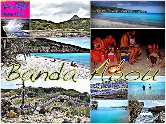 The best beaches, the best diving, favorite BBQ spots, moonscapes where ocean meets cliff in spectacular explosion...
It's all in Banda Abou.
In Curaçao, the only directions you need are upwards and downwards. Banda a riba and banda a bou. (Banda means side.)
"Ah," thought I when I first got here, freshly imported from the lands of "up North" and "down South". "That makes sense."
But it didn't.
 Meet Curaçao.
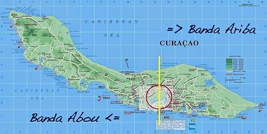
Note, please, the small black arrow below where it says Caribbean Sea. See it? That points North. The red circle is the urban area of Willemstad, glorious capital (and only city) of the island. Anything outside the urban area and to the right of the yellow line--so anything to the east-southeast--is Banda Ariba (up). Anything to the left--north-northwest--is Banda Abou (down).
So, in Curaçao, one goes "down North" and, logically, "up South".
But there's good logic behind it. This is the land of the tradewinds. And the wind blows from--taah-daaah!--the East. Ariba. Upwind. The island is divided into the upwind side and downwind side.
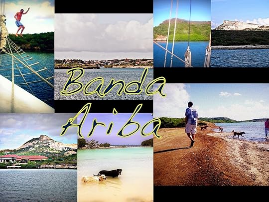 Taffelberg, the gorgeous residences of Spaanse Water & Jan Sofat,
St Joris and the Jan Thiel dog beaches--and, most of all, peace and quiet...
It's all in off-the-beaten-path Banda Ariba.
My intuitive north=up theory? Dead in the water. (At least it's nice, clear, warm Caribbean water.)
... said no one in Curaçao, ever.
 The best beaches, the best diving, favorite BBQ spots, moonscapes where ocean meets cliff in spectacular explosion...
It's all in Banda Abou.
In Curaçao, the only directions you need are upwards and downwards. Banda a riba and banda a bou. (Banda means side.)
"Ah," thought I when I first got here, freshly imported from the lands of "up North" and "down South". "That makes sense."
But it didn't.
 Meet Curaçao.
Note, please, the small black arrow below where it says Caribbean Sea. See it? That points North. The red circle is the urban area of Willemstad, glorious capital (and only city) of the island. Anything outside the urban area and to the right of the yellow line--so anything to the east-southeast--is Banda Ariba (up). Anything to the left--north-northwest--is Banda Abou (down).
So, in Curaçao, one goes "down North" and, logically, "up South".
But there's good logic behind it. This is the land of the tradewinds. And the wind blows from--taah-daaah!--the East. Ariba. Upwind. The island is divided into the upwind side and downwind side.
 Taffelberg, the gorgeous residences of Spaanse Water & Jan Sofat,
St Joris and the Jan Thiel dog beaches--and, most of all, peace and quiet...
It's all in off-the-beaten-path Banda Ariba.
My intuitive north=up theory? Dead in the water. (At least it's nice, clear, warm Caribbean water.)


No comments have been added yet.


