
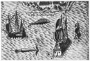
Old maps and sea charts are fascinating documents because they reflect what peop...
Old maps and sea charts are fascinating documents because they reflect what people feared from the deep. Oliver van Noort established a blockade on Manila Bay in 1600 and their visual account shows giant bangus and pusit as big as their ships! Pls share.
2014
2014


No comments have been added yet.
Ambeth R. Ocampo's Blog

- Ambeth R. Ocampo's profile
- 403 followers
Ambeth R. Ocampo isn't a Goodreads Author
(yet),
but they
do have a blog,
so here are some recent posts imported from
their feed.

