
A Bit More Rain in Kyoto Than Normal
Nikon D4 + Nikkor 24-70mm f/2.8 @ 24mm — 1/1000 sec, f/7.1, ISO 500 —
map & image data — nearby photos
running high
Courtesy Typhoon #18
Kamo River from the Ooike Bridge
鴨川、大池大橋から(京都市)
“Typhoon #18” for 2013 rolled by this morning, bringing lots of rain and the once-every year-or-so high water
in the Kamo River. This post is essentially a repeat of the high-water posts from 2010
and
last year, except this time there was significant flooding elsewhere in Kyoto.
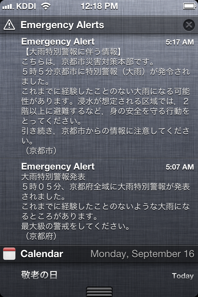
If I'd had my iPhone with me while sleeping, I would have been awoken at
5am by the emergency alerts from Kyoto Prefecture and Kyoto City, warning
of heavy rain. I'd never seen one of these before.
When growing up in Ohio, the National Weather Service would issues
different level alerts for tornados and storms: first a low-level “watch”,
then if the danger became immediate, a “warning”. Warnings were rare.
Japan had the same two levels of warnings until a third,
higher-than-“immediate danger” level was added this summer:「特別警報」(“Special Warning”). This would be
reserved for calamities — rain, wind, snow, tsunami, volcanic ash, etc. — that might
happen once in a generation.
The first ever such alert was issued this morning, for all of Kyoto Prefecture, as seen at right.
What particularly caught my eye (when I noticed this on my phone five
hours later) was the almost conversational sentence: “It's possible you've
never experienced heavy rain like this in your life”.
Having grown up in Ohio, I like a good storm; I'm bummed I missed it. Now I know what
all the sirens I vaguely heard through my sleep were.
Here's what the rain radar looked like at the time of the alert. The small black square to
the lower-right of center is where I live.
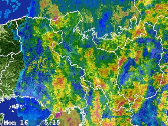
午前5時15分のレーダー。
中心の右下の黒点は私の家(京都市左京区岡崎)
Frankly, the radar looked much worse (much more red) a couple of weeks ago when the last typhoon came near,
but for whatever reason the high water and flooding never materialized
then.
Anyway, it takes the water a couple of hours after the heaviest rain to
accumulate from the mountains to the river near me, but I didn't pop out to
take a look until five hours later, so the water had already receded
considerably.....
Nikon D4 + Sigma “Bigma” 50-500mm OS @ 95mm — 1/1000 sec, f/5.6, ISO 500 —
map & image data — nearby photos
Debris
You can see all the debris that had accumulated against the stone fence toward the right, showing
how high the water had been.
The bridge in the background is the Sanjo Bridge. To illustrate what the river looks like normally, this next photo, from
“Terrace Dining Over Kyoto's Kamo River”,
shows the same scene a couple of years ago from the opposite direction,
from that bridge looking toward where I am now.
Nikon D700 + Nikkor 14-24mm f/2.8 @ 14mm — 1/400 sec, f/11, ISO 720 —
map & image data — nearby photos
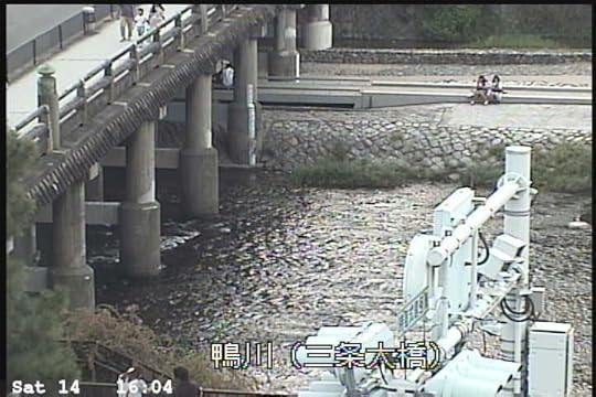
Normal Situation
普通の状況(11年の夏の撮影)
To further illustrate, here's a shot from even further down, looking back at both bridges,
from “Skipping Rocks with Kenny” back in 2011....
Nikon D700 + Voigtländer 125mm f/2.5 — 1/400 sec, f/2.5, ISO 280 —
map & image data — nearby photos
Relatively Low Water
三条大橋、浅い水位(11年の冬の撮影)
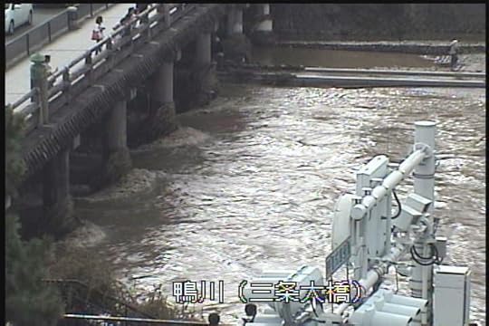
Back to today...
Nikon D4 + Sigma “Bigma” 50-500mm OS @ 78mm — 0.3 sec, f/25, ISO 100 —
map & image data — nearby photos
Sanjo Bridge
三条大橋(今日の撮影)
Having recently posted
“The Effect of Shutter Speed on the Appearance of Flowing Water”, I tried a few shots at different speeds to create a sense of flow, but in this case the “angriness” of the water seems more
pertinent than “smooth flow”, so it turns out that a relatively short 1/13th second shot seems most appropriate:
Nikon D4 + Sigma “Bigma” 50-500mm OS @ 240mm — 1/13 sec, f/13, ISO 100 —
map & image data — nearby photos
♪♫ ♪ Under the Boardwalk... ♪ ♪ ♫
As a result of the typhoon, the bullet train line was shut down, as were
most of the expressways in this part of the country. Today was the last of
a three-day weekend, so everyone who was going to be traveling on the
highways got diverted into the city and follow their car navigation systems
looking for a way west out of the city, and there are only two: Route 1 and Sanjo Street,
and the latter, at least, was a parking lot:
Nikon D4 + Sigma “Bigma” 50-500mm OS @ 290mm — 1/640 sec, f/6.3, ISO 1400 —
map & image data — nearby photos
Sanjo Street
ample parking
三条通りは駐車場に成りました
When I decided to take a pop out to the river with the camera this
morning, I knew things were a bigger deal than I'd first thought when I
came out of the garage and saw the traffic on my street. Normally it's
pretty quiet, but due to its particular circumstances, it quickly becomes a parking lot itself when the expressways are
shut down. Today was the 2nd time I'd seen this.
Luckily I travel by scooter, so traffic was not an issue. 
Nikon D4 + Sigma “Bigma” 50-500mm OS @ 50mm — 1/25 sec, f/22, ISO 100 —
map & image data — nearby photos
Looking South from the Sanjo-Street Bridge
三条大橋から南へ
Nikon D4 + Sigma “Bigma” 50-500mm OS @ 50mm — 1/100 sec, f/9, ISO 100 —
map & image data — nearby photos
Casualty
割れた橋の柵
The stone fence here did not fare as well as the one seen in “Debris” above, buckling under the weight of
the flow. The inscription on the fence says “1994”.
Nikon D4 + Sigma “Bigma” 50-500mm OS @ 50mm — 1/200 sec, f/6.3, ISO 100 —
map & image data — nearby photos
Not Quite Worth
the advertised “1,000 words”
I don't know that this is much better, but here's a short video I shot at the same time. Warning: sound of rushing water is loud.
Nikon D4 + Sigma “Bigma” 50-500mm OS @ 170mm — 1/400 sec, f/9, ISO 320 —
map & image data — nearby photos
Slim Pickings
or gorgeous feast. I'd guess the former, but I don't know.
Nikon D4 + Sigma “Bigma” 50-500mm OS @ 170mm — 1/400 sec, f/5.6, ISO 180 —
map & image data — nearby photos
Stump
Nikon D4 + Sigma “Bigma” 50-500mm OS @ 140mm — 1/320 sec, f/5.6, ISO 140 —
map & image data — nearby photos
Smile
Nikon D4 + Sigma “Bigma” 50-500mm OS @ 240mm — 1/500 sec, f/6, ISO 200 —
map & image data — nearby photos
Worthless
The cameras in the center of the shot above, above “Book Off” on the north-west corner of Sanjo Kawabata, are for the Kyoto
Prefectural water-management system. You can (normally) see a recent shot of the river on their site, such as these:
a couple of days ago
二日前
this afternoon
今日の午後
Unfortunately, the “this afternoon” shot, from when the water had
receded quite a bit, was the only image I could get since 9pm last night.
When there's lots of rain, the Kyoto Prefectural water-management web site
becomes utterly inaccessible. I don't know what my tax yen is going
toward.... it's like having insurance except when you're in an accident.
Nikon D4 + Sigma “Bigma” 50-500mm OS @ 95mm — 1/250 sec, f/5.6, ISO 100 —
map & image data — nearby photos
Nikon D4 + Sigma “Bigma” 50-500mm OS @ 95mm — 1/320 sec, f/5.6, ISO 100 —
map & image data — nearby photos
Nikon D4 + Sigma “Bigma” 50-500mm OS @ 170mm — 1/400 sec, f/5.6, ISO 200 —
map & image data — nearby photos
More Traffic
Even the little river by my place, whose level is normally well controlled because it's an offshoot from
a canal, was running a bit high and was a completely-opaque brown:
Nikon D4 + Nikkor 24-70mm f/2.8 @ 35mm — 1/100 sec, f/6.3, ISO 100 —
map & image data — nearby photos
Shirakawa River
白川、京都市左京区岡崎
But none of this was “flooding”, but other parts of Kyoto certainly saw flooding for the first time in many years.
Here are a couple of videos showing the famous Togetsukyo bridge (渡月橋) in Arashiyama this morning.
The water was lapping over the bridge. For reference, here's a shot from
“A Few More Shots of That Amazing Rainbow”
showing what the incredibly wide river basin looks like normally...
Nikon D4 + Nikkor 24mm f/1.4 — 1/400 sec, f/8, ISO 100 —
map & image data — nearby photos
嵐山の渡月橋、去年の12月


Jeffrey E.F. Friedl's Blog

- Jeffrey E.F. Friedl's profile
- 13 followers

