
A to Z: A is for Antilles
Welcome to the searing energy of the A to Z Blogging Challenge! This year Quiet Laughter has picked an A-to-Z of FAQs to unveil for you, beloved audience, the secrets of the island life.
Where--and what--the heck is Curaçao?
Because we've got to start somewhere, let's go with where.
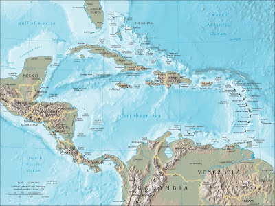 Click on the image to enlarge it. Pretty cool map.The Antilles (ant-EE-lees in English, antees in French) is just a fancy name for the Caribbean islands. You know, that archipelago that creates a curve from the tip of the Yucatan peninsula to Venezuela, and which encloses the Caribbean sea.
At the top you've got the Greater Antilles--that's to say, the big islands: Cuba, Hispaniola (Dominican Republic and Haiti), Puerto Rico, and Jamaica. The Cayman Islands are also included, although they're anything but big.
(Which, once again, proves that size has nothing to do with anything.)
Then, making up the real "curve" on the right and stretching all the way down along the coast of Venezuela (look closely--yep, there's little dots of land there, too), I present to you--taaah-daaaah!--the Lesser Antilles. The tiny ones, the secluded ones, the names you hear every now and then in the news (usually during hurricane season) and couldn't place on a map to save your life: Barbuda, Dominica, Saba, Guadeloupe. Names full of sun and palm fronds waving in a warm sea breeze, margaritas and cold beer, sexy women of long legs and full lips, water so turquoise it puts Photoshop to shame.
The Lesser Antilles have 20 island-states, and some of those are comprised of more than one island. Antigua and Barbuda, a single state, is made up of not one, not two, but three islands. Guadeloupe, same thing. St. Martin is one island but two states: St. Martin (French) and Sint Maarten (Dutch).
Which is why someone thought, "Let's make this part of the world even more confusing," and came up with three further subdivisions:
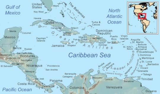
The Leeward Islands are the northernmost of the Caribbean curve. The Windward Islands, the larger of the Lesser Antilles, make up the southernmost part of the curve. And the Leeward Antilles, where Curaçao--finally--is, make up the line along the Venezuelan coast.
 No, that's not Barcelona, Spain.Funky bit of trivia, courtesy of Wikipedia: the name Antilles comes from an old medieval term, Antilia, a mythical group of islands far to the west of the Iberian peninsula that a certain Zuane Pizzigano "discovered." One assumes he did, since he included them in his 1424 nautical chart, for the first time in history and long before Columbus set the record straight. The fact that he was a cartographer, not a sailor, obviously didn't raise any red flags, because from there on out, every reputable chart included Antilia.
 No idea is truly novel.Legend had it that, at the time of the Muslim conquest of Spain (711-788 AC), a bunch of bishops escaped the invading horde and set sail to the west, where they found these islands--Antilia, Satanazes, Royllo, and Tanmar--and founded seven settlements.
Kinda makes one think of the Puritan separatists fleeing England in the 17th century.
In any case, I think the name is quite apropos. The Caribbean is, after all, the land where magic realism is reality. That the name comes from a mythical place in fifteenth-century charts is pure serendipity.
 Isla Margarita. Just add alcohol.
Photo credit: viajeros.comI digress.
So Curaçao, and its sister islands of Bonaire (more on that tomorrow) and Aruba (the Holloway drama made the Friendly Island infamous worldwide), are part of the Leeward Antilles. The other islands in this group all belong to Venezuela, and include Isla Margarita, Venezuela's South Padre Island.
Aruba, Bonaire, and Curaçao make up the ABC Islands, which used to be part of the country known as Netherlands Antilles, together with Saba, St. Eustatius, and Sint Maarten in the northern Leeward Islands. Yep, used to. Because, you see, I happen to live in a country that has ceased to exist.
But you'll have to wait until G day to find out about that little--or not so little--drama.
In the meantime, now you know exactly where in the world Quiet Laughter resides. You may now sleep at night.
Remember to visit the other A-to-Z bloggers--some pretty awesome people out there!
Where--and what--the heck is Curaçao?
Because we've got to start somewhere, let's go with where.
 Click on the image to enlarge it. Pretty cool map.The Antilles (ant-EE-lees in English, antees in French) is just a fancy name for the Caribbean islands. You know, that archipelago that creates a curve from the tip of the Yucatan peninsula to Venezuela, and which encloses the Caribbean sea.
At the top you've got the Greater Antilles--that's to say, the big islands: Cuba, Hispaniola (Dominican Republic and Haiti), Puerto Rico, and Jamaica. The Cayman Islands are also included, although they're anything but big.
(Which, once again, proves that size has nothing to do with anything.)
Then, making up the real "curve" on the right and stretching all the way down along the coast of Venezuela (look closely--yep, there's little dots of land there, too), I present to you--taaah-daaaah!--the Lesser Antilles. The tiny ones, the secluded ones, the names you hear every now and then in the news (usually during hurricane season) and couldn't place on a map to save your life: Barbuda, Dominica, Saba, Guadeloupe. Names full of sun and palm fronds waving in a warm sea breeze, margaritas and cold beer, sexy women of long legs and full lips, water so turquoise it puts Photoshop to shame.

The Lesser Antilles have 20 island-states, and some of those are comprised of more than one island. Antigua and Barbuda, a single state, is made up of not one, not two, but three islands. Guadeloupe, same thing. St. Martin is one island but two states: St. Martin (French) and Sint Maarten (Dutch).
Which is why someone thought, "Let's make this part of the world even more confusing," and came up with three further subdivisions:
The Leeward Islands are the northernmost of the Caribbean curve. The Windward Islands, the larger of the Lesser Antilles, make up the southernmost part of the curve. And the Leeward Antilles, where Curaçao--finally--is, make up the line along the Venezuelan coast.
 No, that's not Barcelona, Spain.Funky bit of trivia, courtesy of Wikipedia: the name Antilles comes from an old medieval term, Antilia, a mythical group of islands far to the west of the Iberian peninsula that a certain Zuane Pizzigano "discovered." One assumes he did, since he included them in his 1424 nautical chart, for the first time in history and long before Columbus set the record straight. The fact that he was a cartographer, not a sailor, obviously didn't raise any red flags, because from there on out, every reputable chart included Antilia.
 No idea is truly novel.Legend had it that, at the time of the Muslim conquest of Spain (711-788 AC), a bunch of bishops escaped the invading horde and set sail to the west, where they found these islands--Antilia, Satanazes, Royllo, and Tanmar--and founded seven settlements.
Kinda makes one think of the Puritan separatists fleeing England in the 17th century.
In any case, I think the name is quite apropos. The Caribbean is, after all, the land where magic realism is reality. That the name comes from a mythical place in fifteenth-century charts is pure serendipity.
 Isla Margarita. Just add alcohol.
Photo credit: viajeros.comI digress.
So Curaçao, and its sister islands of Bonaire (more on that tomorrow) and Aruba (the Holloway drama made the Friendly Island infamous worldwide), are part of the Leeward Antilles. The other islands in this group all belong to Venezuela, and include Isla Margarita, Venezuela's South Padre Island.
Aruba, Bonaire, and Curaçao make up the ABC Islands, which used to be part of the country known as Netherlands Antilles, together with Saba, St. Eustatius, and Sint Maarten in the northern Leeward Islands. Yep, used to. Because, you see, I happen to live in a country that has ceased to exist.
But you'll have to wait until G day to find out about that little--or not so little--drama.
In the meantime, now you know exactly where in the world Quiet Laughter resides. You may now sleep at night.
Remember to visit the other A-to-Z bloggers--some pretty awesome people out there!


No comments have been added yet.


