
Your Selfie in Front of Canada’s Glaciers Could Help Save the Planet

It’s been estimated that humans take up to 92 million selfies a day — and that was back in 2022. And when travelers are exploring new places, they probably take more than their fair share of selfies and destination photos. Now, in western Canada, five wel-known parks are taking advantage of that desire to capture the moment by asking visitors to share their glacier selfies with researchers. It ensures each visit leaves behind something more meaningful than footprints: environmental data.
Launched this year, “GlacierReach” is a community science program that enlists everyday park visitors to monitor rapidly disappearing glaciers in Canada’s Glacier National Park and Jasper National Park. It’s a partnership between the Government of Canada, Parks Canada, BC Parks, the BC Parks Foundation, and the University of Waterloo, and ensures every photo shared becomes an important piece of data. It’s also called the “Icy Initiative,” because rather than encouraging travelers to take photos of themselves — selfies — they’re asked to take photos of the ice — hence, “icies.” (But it’s okay if you’re in it, as long as you can see the glacier, too).

Photo: Parks Canada/Luuk Wijk
At glacier viewpoints in the two national parks, as well as Bugaboo, Garibaldi, and Mount Robson provincial parks in BC, visitors will find one to three “Icy Stands” at viewpoints in front of the parks’ glacier lookouts. Each stand has a sturdy phone mount in a fixed location, creating a straightforward process: Set your phone in the holder, snap a photo of the glacier, and upload it immediately via a QR code on the stand or later through the GlacierReach website. The fixed angle of the phone stands ensures each photo is from the exact same angle, and thanks to location data, researchers can use the images to build a time-lapse visual record of changes in the glaciers, like retreats, thinning, or breakage.
“Glaciers are remarkable features of B.C.’s provincial parks,” said Minister Tamara Davidson of BC Parks’ Ministry of Environment and Parks, in the program announcement. She calls the initiative “community research in action.” “When the public engages with science, it deepens our understanding of these rapidly changing landscapes,” she said, “which has never been more important.”
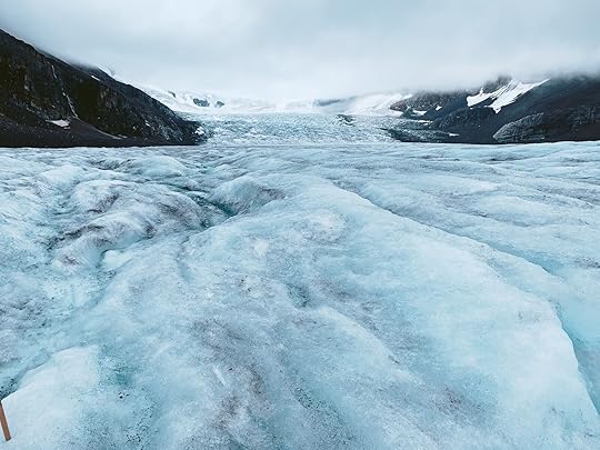
Athabasca Glacier, Summer 2019. Photo: Suzie Dundas
Canada is home to some of the largest concentrations of ice outside of the polar regions. The glaciers store huge amounts of fresh water, feeding rivers and entire ecosystems in the summer, supporting communities and agricultural regions.
Western Canada’s glaciers are disappearing at alarming speed. Recent measurements at Jasper’s Athabasca Glacier, which has been receding for roughly 125 years, showed more ice loss in 2023 than in the entire decade before that. Glaciers in Glacier National Park are melting faster than anywhere else in Canada, with the park’s Illecillewaet Glacier retreating an average of 34.9 feet per year since 1887. Glaciers in British Columbia’s provincial parks are also at risk, with estimates showing that the ice cover in Garibaldi Provincial Park has decreased by more than 51 percent since the late 1800s.
For scientists, it’s nearly impossible to monitor Canada’s thousands of square miles of glacial cover. But each photo from the various Icy Stands will act as a real-time visual report, helping researchers track changes in the park landscapes. So if you’ve ever felt self-conscious about taking a photo or selfie when traveling, don’t — your quick snap could be critical to the future of climate change action. You can feel good knowing your photo ended up in an important scientific database, rather than just your Instagram feed. 


Matador Network's Blog

- Matador Network's profile
- 6 followers

