Backpack the West Loyalsock Loop-Loyalsock State Forest
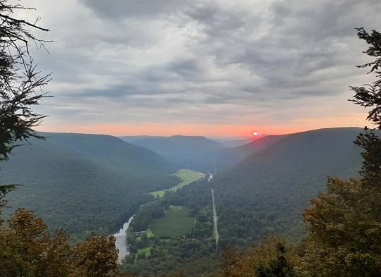
 Sunrise from Smiths Knob
Length: About 20 miles
Parking: Dunwoody Road: 41.342693, -76.738965 . Little Bear Creek Road: 41.355676, -76.859364 . Little Bear Creek Road will probably be a more popular trailhead for most people.
Trail conditions: Good. The Loyalsock Trail (LT) is generally well marked and maintained. There are brushy areas. Other trails are also in good shape. There are two unblazed trails on this loop that were also in good shape. You should have good navigational and route finding skills for this loop. If you don’t want to hike the unblazed trails, you can bypass them on marked trails. However, I feel this route is the most scenic.
Difficulty: Moderate. Most of the terrain has gradual descents and inclines. Trails get steeper around Smiths Knob and Snake Run.
When I hiked it: August, 2025
Water: Usually plentiful. Loop crosses many streams.
Highlights: Scenic streams, creekside hiking, cascades, wildflowers, fine campsites, views, hemlocks, meadows, old CCC camp site, old LT route, pine and spruce forests.
Issues: Patches of nettle on Painter Run. Southern part of loop follows forest roads, which I found to be nice, easy hiking. One short section of forest road had some gas drilling traffic. This loop crosses many creeks, do not attempt in high water.
Direction of description: Counterclockwise from Dunwoody Rd. I parked there to camp at Smiths Knob.
Description: The Loyalsock State Forest has long been loved by hikers and backpackers due to its beauty. I’d been curious to see if a loop was possible along the western end of the famed Loyalsock Trail. I decided to check it out.
Overall, I was impressed and this loop exceeded my expectations.
From Dunwoody Road, I followed a horse or cross country ski trail down to near Hessler Branch. Look to your right to see a hunting cabin, and some spring pools in the woods. Look for an unblazed trail going down to the cabin. Take it. Pass the lodge and look for the trail enter the hemlocks. This unblazed trail is very scenic as it goes under hemlocks along Hessler Branch. When I hiked it, it was easy to follow. Reach a yellow trail, turn left and turn left on Grandad Trail at a sign. Hike up Grandad Trail along a tumbling creek, it’s a very nice trail. Level at the top with hemlocks and turn right on the LT. You will follow the LT most of the way to Little Bear Creek Road, below Smiths Knob.
Explore scenic forests with blueberry glades and ferns. Descend to beautiful Shingle Run with great camping and cascades under hemlocks. Hike over a ridge and descend to isolated Snake Run with another nice campsite. The creek here can be a trickle or dry in summer.
A steep climb follows out of Snake Run. The trail levels and then gradually descends. Reach a forest road (Red Ridge Road) and I turned right, leaving the LT. I followed the road and the LT soon rejoined. The LT left the road, passed a view of the Loyalsock Creek and made a steep climb to Smiths Knob with fantastic views. There is also a great, dry campsite here.
The LT descends steeply, levels, and passes another view. The long descent continues to Little Bear Creek Road and a trailhead. Turn left and hike up the road, a scenic walk with the creek, hemlocks, and hunting cabins. Turn left onto Painter Trail along Painter Run, a highlight. This scenic creek has mossy cascades, pools, wildflowers, and hemlocks. There’s even Canadian yew, a rare sight. There are also several creek crossings, so don’t attempt in high water. Patches of nettle are common in summer. Painter Run is very scenic. As you climb, the gorge narrows and the LT joins; veer right onto the LT. Painter Run has some small campsites, but they’re not very good. Climb to Red Ridge Road and turn right.
The road is a nice walk. It curves through the hemlock glen on Red Run and reaches the Sand Spring Camping area, a beautiful primitive car camping area and former CCC camp. Pine trees surround the sites. Hike down Sand Spring Road to Little Bear Creek Road and turn left; here you might encounter some gas drilling traffic. Climb and turn left onto Firetower Road. Veer right onto Miller Trail and descend. After a half mile or so, look for an obvious trail to the right with a wooden gate; this is the old LT route and it still has blazes (if you miss it, don’t worry, Miller Trail will take you to the same spot). Follow the Old LT down, passing odd wooden gates. At the bottom of the hill rejoin with Miller Trail and turn right.
Reach the current LT and turn left, crossing meadows with flowers, pine, and spruce. The LT turns left off the obvious old road, but continue straight. Complete the loop and continue up to the parking area on Dunwoody Road.
Get out there!!
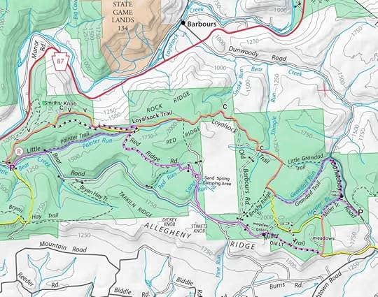
 Route is highlighted purple; not blazed that way on the ground. C=campsites; V=vistas; P=parking. Dotted trails (other than Miller Trail or Red Run Rd) are the unblazed trails. Old LT still has faded LT blazes.
View this post on InstagramA post shared by Jeff Mitchell-Outdoors Author (@hiking_mitch)
View this post on InstagramA post shared by Jeff Mitchell-Outdoors Author (@hiking_mitch)
View this post on InstagramA post shared by Jeff Mitchell-Outdoors Author (@hiking_mitch)
View this post on InstagramA post shared by Jeff Mitchell-Outdoors Author (@hiking_mitch)
Jeff Mitchell's Blog
- Jeff Mitchell's profile
- 3 followers


