Backpack the Loop of Meadows-Quehanna Wild Area
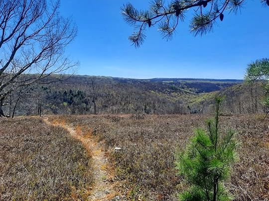
 Crawford Vista
Length: About 30 miles
Parking: There are several places to park, but the main trailhead is at Beaver Run Dam. 41.261247, -78.257991
Trail blazes: Most trails are yellow, a few are red. Quehanna Trail is orange.
Trail conditions: Overall, pretty good. Trails are generally easy to follow. Most trail junctures have signs, but some do not. You’ll need to pay attention for turns. Trail is wet and muddy in places.
Terrain: Moderate and hilly. Biggest climb and descent are Porcupine and Sanders Drafts.
Issues: Nettle is a problem in Porcupine Draft in summer. Sun exposure in hot weather.
Highlights: This is a remarkably diverse and scenic loop. Extensive meadows, gorges, glens, diverse forests, cascades and falls, scenic streams, isolation, wild elk, moss forest, a few views, good campsites.
Best time to hike: May for flowers, June for mountain laurel blooms, July for rhododendron blooms, September for elk bugling, October for fall colors.
Direction of description: Clockwise from Beaver Run Dam. I think clockwise is the best way to hike the loop as it better showcases the scenery.
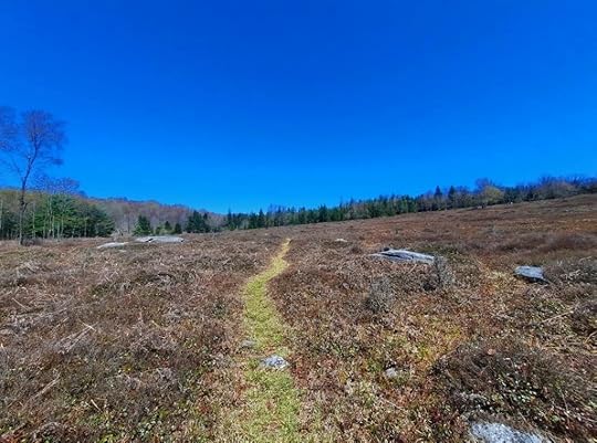
Description: I love when you’re hiking in the woods and then it opens up and crosses a meadow. The Quehanna has lots of meadows and I’ve wanted to create a loop that showcases all its meadows and glades. This is what I came up with. I finally hiked this loop and was blown away by its scenery and diversity. Other than Dolly Sods in West Virginia, no other loop has as much meadow hiking in the east. This loop can be a decent alternative to the very popular Dolly Sods; some sections of this loop looked very similar.
In a few miles, you can be hiking along a tumbling creek with waterfalls and mossy boulders, meadows and teaberry glades, open hardwoods, fern meadows, rhododendron tunnels, beaver ponds and dams, views, laurel jungles, forests of pine and hemlock, and even a stunning moss forest. I’ve never seen such diverse scenery packaged along a loop like this and I’m surprised this loop isn’t more famous.
From Beaver Run Dam, walk up the road and turn left onto the yellow trail. Hike through glorious pine forests. Turn left and then right on the Marion Brooks Loop with more pines and the first meadow. Cross Quehanna Highway and take a peek at the white birch forest in the Marion Brook Natural Area. Walk the road for a short bit and turn right onto Marion Brooks Loop with more meadows.
Turn right on the East Cross Connector (ECC) and follow the Teaberry Loop with more meadows and a fine view. Return to the ECC and turn right on it, heading north. Reach the Quehanna Trail (QT) and turn right. Descend Porcupine Draft with big boulders, cascades, and small falls near the bottom; lots of wildflowers too. Reach beautiful Red Run and then hike up gorgeous Sanders Draft with its fine camping and stunning collection of cascades and falls among huge boulders. What a creek.
At the top, turn right onto Sanders Trail and follow it through beautiful forests of hardwoods and hemlocks and cross a meadow. Continue to Hoover Road and turn left. Turn right onto Gore Vista Road or Trail and veer straight or right onto Gore Cut off Trail. Hike along a huge meadow. Turn left onto Bailey Log Trail with pine forests that becomes a vast jungle of laurel, which must be an impressive sight when it blooms in June.
Cross Wykoff Road and follow Wykoff Trail with hemlocks, creeks, and several meadows. Follow Ligament Trail and reach Quehanna Highway, follow the red blazes to Bellefonte Posse Trail. (No need to follow the yellow Panther Run extension trail, it simply parallels Bellefonte Posse and then rejoins it). Turn right onto Panther Run Trail, a gem. Hike into a valley with beaver dams, ponds, and meadows. Turn right onto a road and follow the yellow blazes over a hill and down into another valley with extensive meadows, huge boulders, and spruce forests in the distance. This spot looks like Dolly Sods. Enter a trail highlight, a simply stunning spruce and moss forest. You won’t believe all the moss.
Cross Reactor Road and follow Red Run Trail to Ralph Seeley Trail with more meadows. Cross Meeker Run and turn left on the ECC. Hike along Meeker Run with two campsites, a falls and deep pool. Take the trail up to Crawford Vista, a gorgeous view with dry camping. Turn left and hike down to Mosquito Creek and Bridge Trail with camping at the bridge. Follow Bridge Trail along beautiful Mosquito Creek and extensive meadows.
After crossing a small creek and before nearing the woods, I took a bushwhack to the left across meadows and along deer trails. It was totally worth it, and the brush was low. I wanted to see the oxbow loop of Mosquito Creek (at about 41.235249, -78.264989 ); the views were nonstop. Wow. I then veered up above Beaver Run and reached what I jokingly called “Dolly Sods Knob” (at about 41.237088, -78.264641 ), a stunning valley of meadows with spruce, tamarack and pine that looked like Dolly Sods. I continued along the meadows with more views, crossed a boggy area, and rejoined the ECC. If you’re up for some adventure and are comfortable with off trail hiking, consider taking the bushwhack route.
I followed the ECC along more meadows, across a beaver pond on a bridge, and along the Beaver Run Dam lake. I followed the road back to the parking area.
This loop was a stunner, one of the most diverse and beautiful in the mid Atlantic if not the east. It qualifies as one of PA’s Best Weekend Backpacking Loops. Get out there and enjoy it.
 Panther Run Trail approaching the moss forest
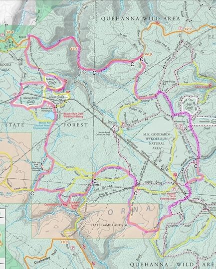
 Route highlighted in purple, not marked that way on the ground. C = camping or potential camping. Blue dots are falls or cascades. Light blue dots are beaver dams and ponds. Red dots are the bushwhack I took. Locations are approximate. This map has one mistake, “moss forest” should be at the “C” on Panther Run Trail.
View this post on InstagramA post shared by Jeff Mitchell-Outdoors Author (@hiking_mitch)
View this post on InstagramA post shared by Jeff Mitchell-Outdoors Author (@hiking_mitch)
View this post on InstagramA post shared by Jeff Mitchell-Outdoors Author (@hiking_mitch)
View this post on InstagramA post shared by Jeff Mitchell-Outdoors Author (@hiking_mitch)
View this post on InstagramA post shared by Jeff Mitchell-Outdoors Author (@hiking_mitch)
Jeff Mitchell's Blog
- Jeff Mitchell's profile
- 3 followers


