
Los Angeles Fires and Aftermath
8:00pm It’s three hours later here in Indiana, where it is 16° and snow is approaching (and will add to the foot of it preserved by freezing temperatures since last weekend):
So I will now leave the command post in my basement office. I’ll get back on the case tomorrow morning.
Here’s hoping that all we’ll have to report then is grief over the devastation. Unlike so much else we’ve been visiting in this report, that one is incalculable, and has barely started.
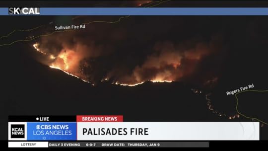
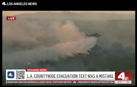
7:30pm All the TV stations are mostly covering human interest stories. KPCC/KCAL are talking about how one of the “super scooper” aircraft struck a drone and was grounded after that. But they do have their own chopper, shooting the Palisades Fire, cresting the ridge of the Santa Monica Mountains. If all goes well, the winds will blow it back on itself. Meanwhile, there are plenty of aircraft on the case, as one can see on FlightRadar24. Here’s a screen grab of the fire:
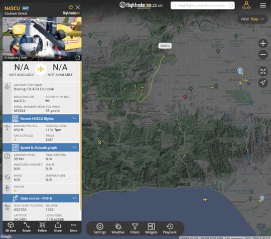
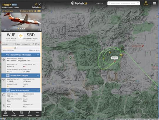
6:22pm This grab from FlightRadar24 shows the collection of aircraft over the Kenneth and Palisades Fires. I’ve highlighted the flight path of the Chinook that has been making many loops and drops over the Kenneth fire:
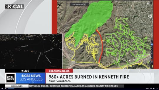
6:20pm KCAL is doing a good job of covering how well aerial fire fighting is Keeping the Kenneth Fire from destroying homes:
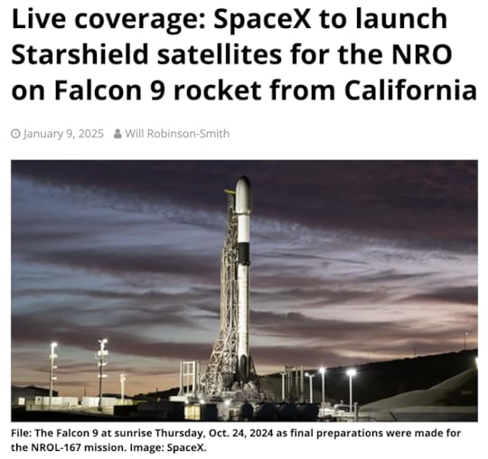
6:10pm As a break from the dread and heartache, if you’re in Southern California and can see through or past the smoke, tonight’s launch from Vandenberg should be a good show, especially as the rocket enters space, and the exhaust expands in the sunlight. More here at Spaceflight Now:
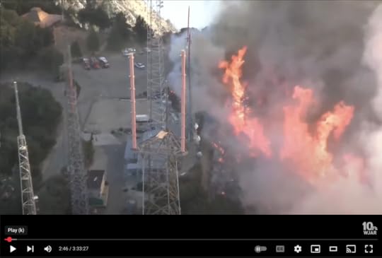
5:50pm And here is an extended video of the Eaton fire failing to burn the “Fox Compound”—the eastern-most of the Mt. Wilson TV and FM transmission facilities. It is shot from the tower cam on KNBC.4’s tower. Amazing stuff:
The two towers on the left are former and auxiliary ones for KTTV/11, with KTWV/94.7 farther down on the one farthest left. The two red prongs are KCOP/13 and KTTV/11’s current main antennas.
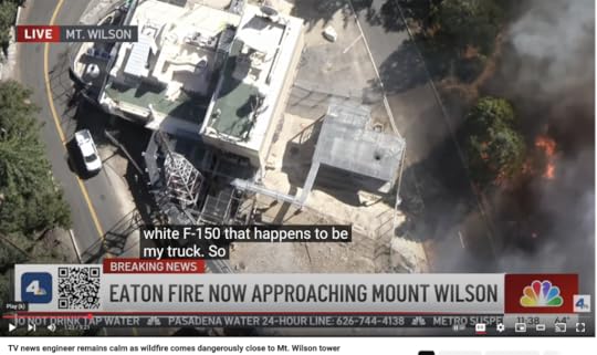
5:43pm KNBC/4’s conversation with my friend Dennis Doty at the station’s Mt. Wilson transmitter is now on YouTube. Dig how the fire comes right up to the road, live, while Dennis calmly explains that nature taking its course is no danger to the facility. A screen grab:
4:30pm Here is the flight path of the Chinook that the KNBC reporter just saw fly overhead:
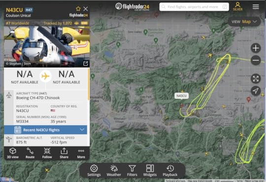
Note the many other aircraft in the area.
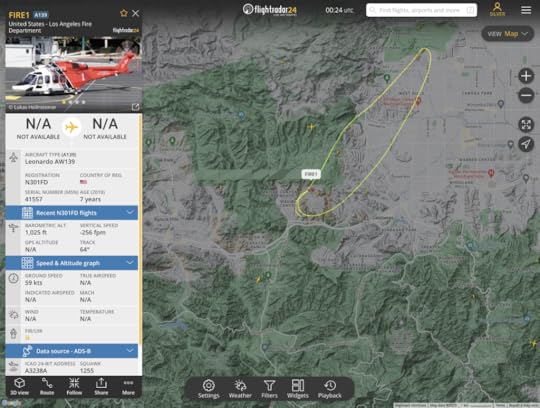
4:23pm The shot below may be of FIRE1, of the LAFD:
4:15pm Via KNBC and KCAL, the aerial assault on the Kenneth Fire appears to be succeeding for now, which is why other stations are reporting on the Palisades and Eaton fire aftermaths. Nice video from KNBC:
3:20pm Via KCAL, the Kenneth Fire is moving westward, though they are evacuating the west end of the San Fernando Valley.
3:13pm The press conference the guy with Marrone on his jacket (not sure his title) said at four to five thousand or more structures are lost. This places it third behind the Camp (18,804) and Tubbs (5,636) fires in California history.
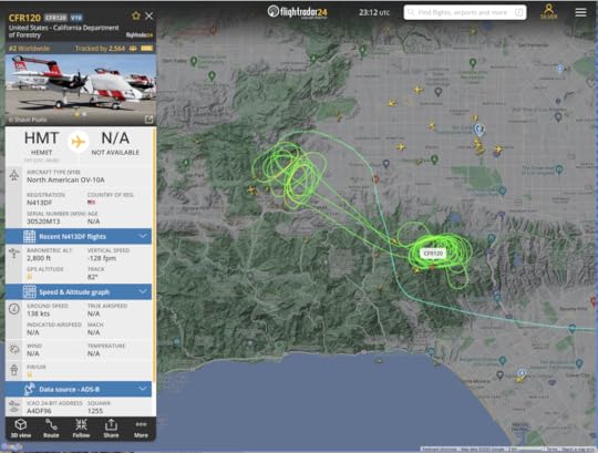
3:10pm Flight paths from FlightRadar24 show how the new Kenneth Fire in the West Hills (Upper Las Virgenes Canyon Open Space Preserve), 50 acres large, is getting attention, along with the north flank of the Palisades fire:
3:00pm Stations are breaking away for a press conference. This is a bummer, at least for KCAL’s coverage, because they were showing exactly where the Hills Fire was moving toward streets and residences. This is in Ventura County, which will bring in new administrative bodies.
2:55pm Via KCAL/9: With wind sure to pick up (which they already are), aerial fire fighting has a lot to do, ASAP. There is another fire, called the Creek Fire, in the Angeles National Forest, near Big Tijunga canyon. Evacuations are probably coming for Calabasas, I think they just said.
2:45pm Via KCAL/9: There is a new brush fire, the Hills Fire, north of the 101 and to the west of West Hills, in the Los Virgenes Open Space Preserve. Here is the flight path of a tanker dropping water on it:
They have live chopper video:
2:40pm Word on a private forum from Mt. Wilson: While the fire has been s burning uphill (to the north) the wind is downhill (to the south). There is adequate brush clearance, and firefighters are allowing the fire to clear out “flash fuels.”
1:53pm All the TV stations are covering President Biden’s press conference, with VP Harris following. One interesting thing: Harris says insurance companies cancelling coverage. We need more info about that. Randy Moore of the U.S. Forest Service is making sense about the conditions that make the fires hard to fight, and what’s being done by fire fighters. The next guy just said, I think, that 360,000 people are under mandatory evacuations. Meeting the needs of thousands who have lost homes is a huge problem. Removing debris, one official just said, will take “months to a year.” It’s now 2:22. This is going long. Mostly it’s about forms of federal support coming in… and at 2:34 stations are cutting away and summarizing the briefing. Only KTTV/11 “Fox 11” is staying with the feed… and now at 2:37 they’ve cut away as well.
1:33pm I have tabs open to channels 4, 5, 7, 9, and 11 (NBC, Independent, ABC, CBS, and Fox), and all of them are reporting stories, mostly about Pacific Palisades and Altadena, two towns that were largely wiped out in the fires. (Pacific Palisades is part of Los Angeles, and Altadena is an unincorporated suburb in Los Angeles County that presents essentially as the north side of Pasadena. (The name essentially means the higher part of Pasadena.) Most of the coverage is of the human interest kind, rather than the what’s-happening kind. So in some ways, barring flare-ups, this is mostly over.
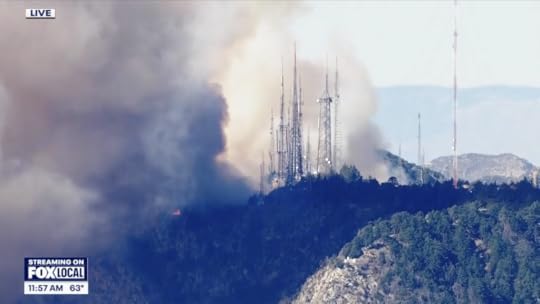
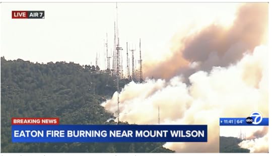
1:30pm KTTV/11: LIVE: Deadly Eaton Fire reaches Mount Wilson summit. Scroll down for the story. A grab:
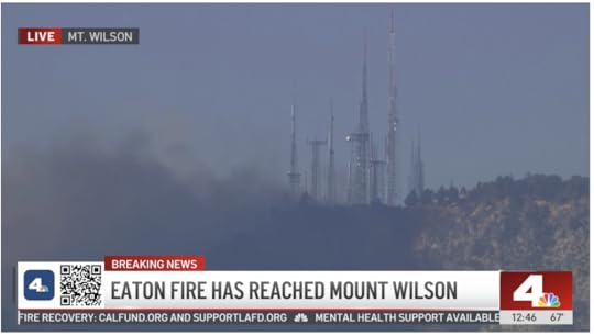
12:45pm KNBC/4: Live updates: Eaton Fire flares up near Mount Wilson summit.
They just mentioned that Dennis Doty, a friend who runs the KNBC/KVEA transmitter facility (which I’ve photographed here), has been in communication with the studios, the station chopper, and the fire fighters—and sounding very calm and professional. Nice to hear.
12:37am KTLA/5: LIVE: Eaton Fire reaches the peak of Mt. Wilson. It’s a live cam view from KTLA’s property, roughly in the middle of the tower farm complex. Here are my photos on Wilson relating to KTLA.
12:31am KABC/7: 5
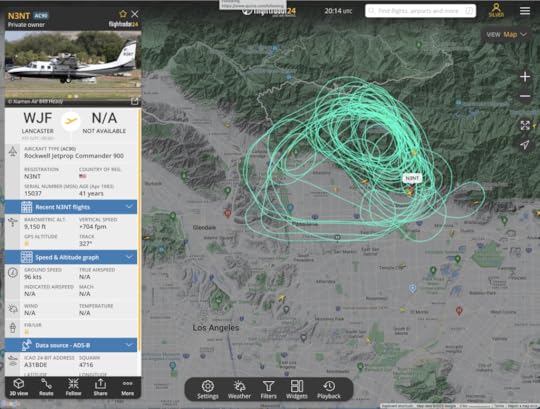
50-75% of Pacific Palisades is gone, ABC7’s Josh Haskell estimates. It looks like more, but hard to tell.Eaton Fire burning near Mt. Wilson.12:10am FlightRadar24 shows only two fixed-wing aircraft circling Mt. Wilson. This is one of them:
None of the TV stations seem to be covering the mountain now. Or at least I don’t see anything on their streams, or on FlightRadar24. I do know that Mt. Wilson’s transmitters are somewhat well isolated from vegetation. That gives me some hope for their survival. Nearly all the stations there have auxiliary transmitters, either elsewhere in the tower farm on Wilson itself, or on Mt. Verdugo or Flint Peak, both in Glendale.
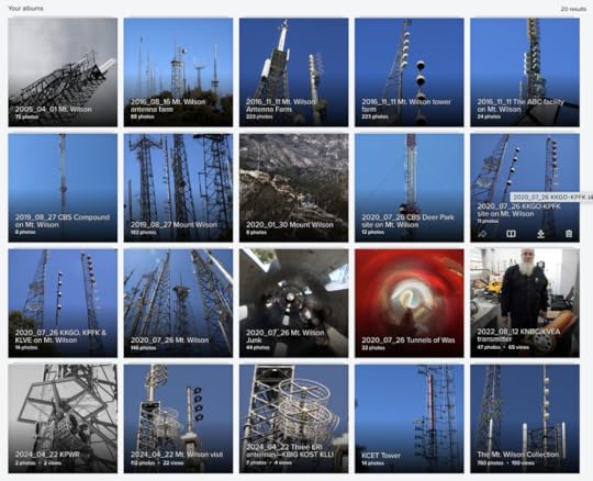
10:50 Nearly all Los Angeles’ TV and FM stations transmit from Mt. Wilson. I visit the site often. Here are twenty photo albums of transmitters on Mt. Wilson, going back to 2005. Go there and search for “Wilson.”
10:41 KABC/7 has live coverage of Mt. Wilson now:
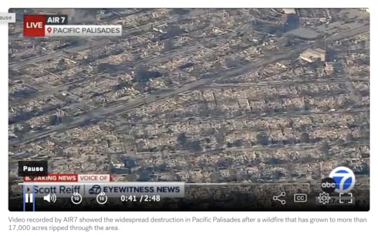
10:35 KABC/7 has an aerial video that shows clearly how much of Pacific Palisades has been wiped out. Looks like most of the town. (Alas, you do have to sit through the :30 second ad first, but it’s worth the wait):
10:29am Friends who work keeping TV and FM transmitters operating on Mt. Wilson have been sending me images of the Eaton Fire encroaching up the mountain face from the south. One just shared this on a private forum, from KCAL/9:
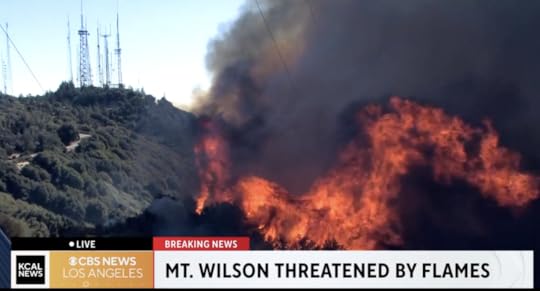
Here is live coverage from KCAL on the Eaton Fire.
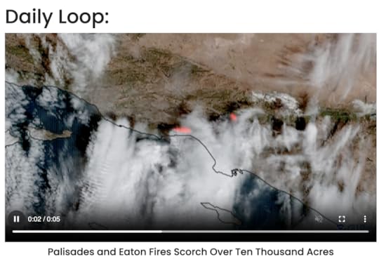
10:17am Here is the .mp4 of the daily loop from CIRA, which I think is the one the New York Post used:
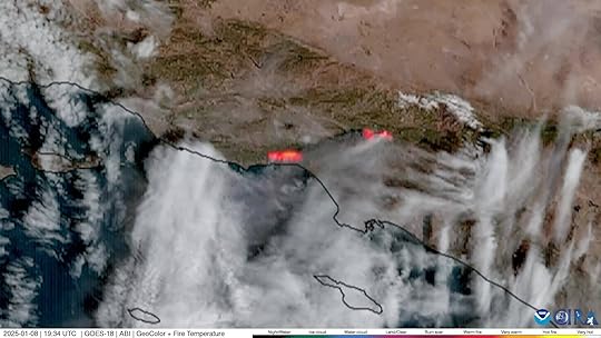
10:14am CIRA is Cooperative Institute for Research in the Atmosphere, at https://www.cira.colostate.edu/. And they have this in their Daily Loop of GOES West:
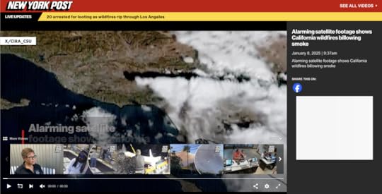
10:11am The New York Post has Alarming satellite footage shows California wildfires billowing smoke, with a disappearing video that begins with this frame showing a source: X/CIRA_CSU:
10:07am The Sun:
SCORCHED EARTH ‘Luckiest home in LA’ seen in devastating pic showing it’s the ONLY building left after whole district razed by wildfire.CITY OF FLAMES Interactive map reveals LA wildfire hotspots & celeb-packed enclaves under threat after stars among 30k forced to flee. People has more of the same, from a celebrity+landmark angle.SATELLITE pictures have revealed whole blocks of homes in Los Angeles have been burned to rubble by the wildfires, but gives no sources. One image:
11:05am Satellite Imaging Corporation should have something. Haven’t dug into it much yet. Not sure I can. I am sure they should step up and provide the public with helpful images and maps.
10:58am Nasa Earth Observatory:
Fires tear through Los Angeles. Images are from January 7. But,,,Explore more than 12,870 images has an enormous variety of scenes from above, mostly from the past, and something current is bound to show up on—Image of the Day.10:50am LAist:
What we know about the fires burning right now and staggering losses so far.Cheat sheet: A quick roundup of SoCal fire coverage and safety resources.Eaton Fire forces 100K people under evacuation orders, 5 deaths reported.Fact check: What really happened with the Pacific Palisades water hydrants? “Water supply was too slow, not too low.”10:45am LA Times:
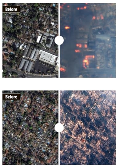
Shocking before-and-after satellite images show destruction of Malibu.Southern California wildfires by the numbers: Location, size, containment and more.One of the most destructive firestorms in L.A. history kills 5, burns 2,000 buildings.7:50am Here is what people need to know. All of these are facts rather than stories:
What homes and other buildings have burned. With addresses.What problems persist (power outages, road closures and blockages, cell coverage that’s gone, fire perimeters that are uncontained)What resources are available, where, and howAll the media are in the story business first, and the fact business second. I salute them for providing the latter (as KCAL and KABC have been doing by showing overlays of road maps on aerial views down on fires in neighborhoods). But we need facts.
Here is one: many people we know in and around Los Angeles are putting up people who have been made homeless by the fires, or have been evacuated from their neighborhoods.
Also, to make clear my connection to region, I’ve lived in California since 1985, am a permanent resident of Santa Barbara, and my wife is a born & raised Los Angelina in a family of eight siblings, nearly all of which, with their progeny and grandprogeny, have stayed in the state. We have countless friends, co-workers and acquaintances throughout Southern California. It is home for us, even though we are currently domiciled in Bloomington, Indiana (which we also love).
7:33am Resources for facts:
LADWP (Los Angeles Department of Water and Power) outage map.maps.wildfire.gov for the Los Angeles region (click on the little squares to see what’s going on there).FIRMS (Fire Information for Resource Management System) map for the same region, showing satellite-spotted hot spots. This selectively can include VIIRS, MODIS, Landsat and other sourcesSoCal Edison power outage page, which has a mapKPCC/89.3, now called LAist, is, far as I can tell, the only regional broadcaster providing continuous coverage of the #LAfires without commercial interruption. It is partnered with KCAL as well. KNX, on 1070AM and 97.1 FM, has 24/7 news, but with commercials. While its AM signal is far larger than its FM one (covering the whole West at night), it identifies as the latter.7:15am KCAL is at East Calaveras and Country Club Drive in Altadena, where the whole neighborhood, and the Altadena Town & Country Club are burned down.
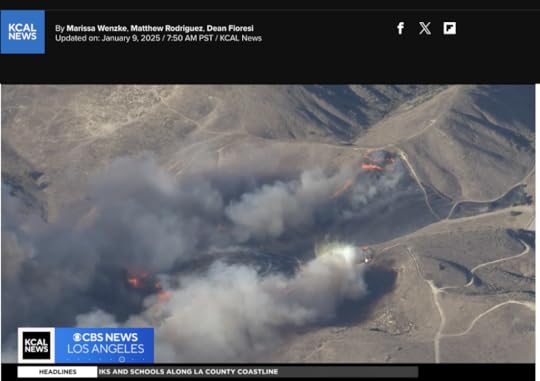
6:39am KCAL/9 and KABC/7 have been my main sources of video news (over the Net, here in Indiana), and the latter is partly back to national (ABC) coverage. KCBS/2 and KCAL/9 are both CBS, and the latter is positioned as the news station, so I’m on KCAL (“kay-cal”) right now. Two screen grabs, one from Altadena and the other from Pacific Palisades:
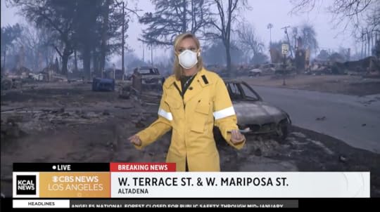
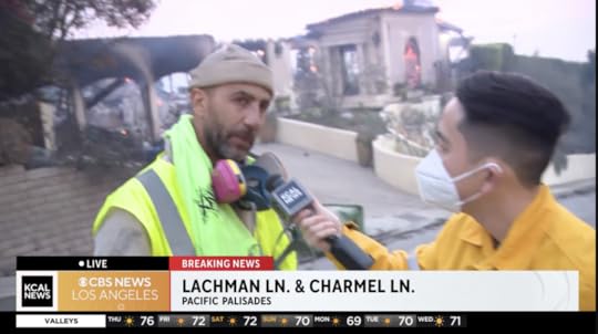 In the Altadena case, there were no surviving homes in view. In the Pacific Palisades case, the guy on the left is a homeowner who stayed to help neighbors hose down their houses and hopefully survive the fire. He and his house survived. Other houses did not. (There was no talk of fatalities, though there were some in Altadena.)


Doc Searls's Blog

- Doc Searls's profile
- 11 followers

