Hike the Tiadaghton/Mid State Trail Loop (One of the Toughest Loops for its Length in the East)
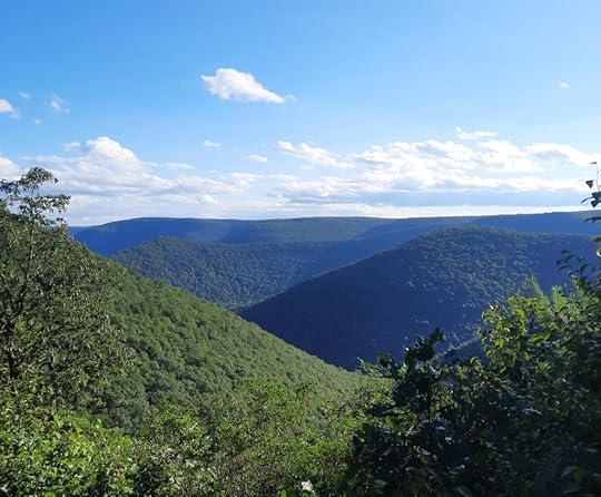
 Kline Ridge Vista on the Mid State Trail. Don’t miss this view.
Length: About 23-24 miles
Difficulty: Very challenging. Possibly the most challenging overnight backpack loop in the Mid-Atlantic with over 6,000 feet of elevation gain. (By comparison, the Black Forest Trail at 42 miles has about 8,500 feet of elevation gain). Steep climbs and descents, but no significant rock scrambling.
Highlights: Views, rock outcrops, ledges, and formations, gorges, different forest types, streams, Pine Creek, Little Pine State Park, narrow ridges, many cascades and small falls when the creeks are flowing, old quarries.
Parking: 41.311688, -77.377059. Large lot here.
Direction of travel: I think counterclockwise from the parking area near Waterville is best. The loop is a little easier to navigate, and the terrain starts off more mild.
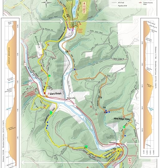
Blazes: The Tiadaghton Trail (TT) is yellow. Mid State Trail (MST) is orange. The trails are blazed pretty well. You will also see a few old blazes of the TT, red with a white “T”.
Amenities: This loop passes through the Little Pine State Park campground with water, restrooms, picnic tables, and trash receptacles. Happy Acres restaurant and store is also along the trail.
Secret hint: Hike after the Eastern States 100 trail race (usually in August), which follows much of this loop. The section of the loop the race follows would be maintained then with even the nettles being cut back.
When to hike: In mid June for the mountain laurel blooms, after the Eastern States 100 race, mid October for fall colors, or when the leaves are off the trees for non-stop views along narrow ridges and the edges of the canyon.
Volunteers: PA Trail Dogs, Eastern States 100, and the Mid State Trail Association maintain these trails. Thanks to all volunteers.
Would I hike it again? Yes.
What would I do different? Take the purple shortcut on the map (not marked that way on the ground).
Issues: Nettle an issue, some blowdowns, tough terrain, navigation might confuse some in Ramsey or heading clockwise from the parking area near Waterville. Camping is somewhat limited, but there are campsites. They tend to be small. There are rocky areas and loose rocks.
Description: This loop is a beautiful and very challenging. It has a lot of great scenery, but you need to work for it. I really enjoyed it. This loop is a best kept secret for those looking to test themselves and enjoy the beauty of the Pine Creek Gorge. It is not nearly as popular as the Black Forest Trail.
The TT was first established decades ago by a Boy Scout camp (I believe) but was then largely abandoned. Thankfully volunteers have brought this beautiful trail back to life, making this epic loop possible. The old TT blazes can still be seen.
From the parking area, turn right onto PA 44 and cross the bridge. Turn left onto Lower Pine Bottom Road and turn left onto the TT, there is a sign. The trail descends to cabins and then follows an old grade above Pine Creek, it is scenic. Climb switchbacks and enter Bull Run. The trail moves closer to Bull Run with many cascades and small falls; this hike is sublime when it is flowing. Climb a little more steeply and reach the top of the plateau for flat hiking. Jog left on a gravel road and follow an old jeep road down, blazes are a little infrequent through here but the trail is obvious. Follow a narrowing ridge with rock outcrops and views. Continue straight, avoiding trails to the left or right. One view has a 180 degree view. Continue to descend, passing a quarry. Reach the rail trail and turn left, cross Pine Creek, and follow the rail trail to a small parking area.
You are now on the MST. Follow PA 44 to the right for a few hundred feet and cross the road to begin a big climb. Along the way are cascades and rock formations. Reach the top with laurel and level hiking. Dip into a glen with a small creek and climb out. Reach a side trail to a view on the left, don’t miss this. It goes to Kline Ridge Vista, the best view on the loop.
Descend to Ramsey Run, a scenic gorge with cascades and tumbling streams. This is also the best camping on the loop. Climb out of the gorge under hemlocks and reach the plateau with more level hiking. Pass a gas pad and descend to a small side creek, cross a road and then Dam Run with a cascade and deep pool in a grotto.
Gradually climb above Little Pine Creek under large pine trees. Reach the state park campground and hike through it. Reach Little Pine Creek Road. Happy Acres restaurant and store is to the left, they even sell ice cream.
Here, I’d take the purple shortcut route. The MST route is very nice, and the rock outcrops are impressive, but the significant effort to climb, only to descend, may not be worth it for some hikers.
If you decide to stay on the MST, climb up a narrow ridge with old quarries and some very cool rock formations. Descend on the Spike Buck Trail into a gorge with a seasonal creek. Cross Boone Run Road and follow the side of the mountain, passing behind cabins with rock outcrops. Descend to Bush Run at a cabin and piped spring. Now climb up Bush Run, it is tough. Hike through an open area with views. The climb gets steeper and rockier, this is the toughest climb on the loop. At the top enjoy a great view. The last climb is done.
Cross Huntley Road and pass through a wet, muddy area. The trail moves close to the edge of the canyon with a cool rock ledge and then a fine view. Begin to descend on an old road and then follow a long series of switchbacks. At the ends of the switchbacks are views, but you have to go off trail for about 20 feet to see them. The switchbacks continue until you reach an old wagon road above the rail trail. Turn left onto the rail trail and follow to your car.
Great job on completing one of the toughest loops in the Mid Atlantic, if not the east.
 Black dots are rock outcrops or formations. Blue dots are larger cascades, there are many more. Purple dots are a recommended shortcut. V are additional views, just off the switchbacks. Red dot described in photo below. C are campsites and are described below. All locations are approximate.
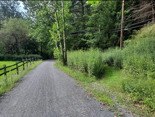
 Red dot on map. If hiking clockwise, you’d want to turn right onto the mowed path. The TT follows an old wagon road that parallels the rail trail and then climbs.
Camping info:
C1- a small grassy opening at the end of an old forest road. Might fit two tents. Dry.
C2- A mossy area on a ledge, small. Maybe two tents could fit tightly. Dry.
C3- Established fire ring and stone furniture where two creeks meet, but hardly any space for even a tent. Not ideal.
C4- Across the creek from the MST, where the MST switchbacks away from the creek. Fire ring with a stone chair. Might fit three tents, maybe four, little overgrown. Scenic with creeks and ledges. Second best place to camp on the loop.
C5- Best camping on the loop. Below the MST in a hemlock grove along the creek. Looks to fit three tents. Has a fire ring.
C6- Small site along a creek for a tent, maybe two but it’ll be tight. Fire ring. Ground is rooty.
You can also camp at the Little Pine State Park campground, but you must pay.
View this post on InstagramA post shared by Jeff Mitchell-Outdoors Author (@hiking_mitch)
View this post on InstagramA post shared by Jeff Mitchell-Outdoors Author (@hiking_mitch)
View this post on InstagramA post shared by Jeff Mitchell-Outdoors Author (@hiking_mitch)
View this post on InstagramA post shared by Jeff Mitchell-Outdoors Author (@hiking_mitch)
View this post on InstagramA post shared by Jeff Mitchell-Outdoors Author (@hiking_mitch)
View this post on InstagramA post shared by Jeff Mitchell-Outdoors Author (@hiking_mitch)
View this post on InstagramA post shared by Jeff Mitchell-Outdoors Author (@hiking_mitch)
View this post on InstagramA post shared by Jeff Mitchell-Outdoors Author (@hiking_mitch)
Jeff Mitchell's Blog
- Jeff Mitchell's profile
- 3 followers


