Backpack the Old Loggers Path-North Loop
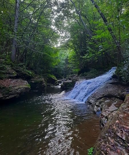 Yellow Dog Run cascades into Rock Run
Length: About 17 miles
Difficulty: Moderate
Terrain: Much of this loop has cruisey or rolling terrain. Steepest sections are in and out of Long Run.
Camping: This loop has lots of great camping and a shelter.
Highlights: Views, creeks, waterfalls, Rock Run, good isolation, good camping, big rocks, great shelter at Doe Run, plenty of cruisey terrain.
Issues: None, really. This loop is pretty perfect. There is an unblazed, but well established, trail. Point A can be easy to miss if hiking clockwise. There are wet areas. Creeks are small, but none have bridges.
Blazes: Old Loggers Path is orange, Cherry Ridge Trail is blue.
Parking: There is a lot at 41.526595, -76.831246, which is where I parked. It is the Cherry Ridge trailhead.
Direction of description: I went clockwise, so that is how it is described. It would be easier to navigate the unblazed trail counterclockwise if you’re unfamiliar with the route.
Description: Wow, what a loop. I absolutely loved this loop, it is ideal as an overnight backpack or long dayhike. It contains almost all of the Old Loggers Path’s (OLP) scenic highlights. While the OLP is a great loop, this shorter loop offers more bang for your buck. I think this loop is one of the most scenic for its length in the Mid Atlantic.
From the parking area, hike the blue Cherry Ridge Trail west (do not follow it around the yellow gate). Enjoy easy terrain with beech and cherry trees. Hemlocks become more common and hike along a small meadow. It is a nice, chill trail. After almost 2 miles, the trail turns left. An unblazed trail goes to the right and crosses a wooden bridge, it goes to Ellenton Road. Stay on the Cherry Ridge Trail.
Climb gradually. After about .5 mile, look for an unblazed trail to the right (Point A). It can be easy to miss going clockwise, so you might want to hike this loop counterclockwise. This unblazed trail is used by trail running races and was well established when I hiked it. It is a pleasant trail, crossing the top of the plateau, gradually descending to an old grade, it passes a meadow and springs, and stays on the grade above Long Run. Then it switchbacks down to Long Run, crossing its several times in quick succession to Point B, where it meets the OLP. The trail juncture at Pont B is obvious, so it may be better to hike this loop counterclockwise.
There are small campsites along Long Run. Now follow the OLP for the rest of the trip, it is blazed orange. Climb steadily out of Long Run, passing several dry campsites. Level on the plateau and hike the cruisey trail through hardwoods. Cross a pipeline swath and descend slightly. A short climb brings you to Sullivan Mountain with its several vistas, ledges, and big rocks. One vista has great dry camping. Tunnel through laurel, enjoy another view to the west, and make a short, steep descent to an old logging road. Hike to Buck Run with camping and large rocks.
Hike the edge of the plateau to Doe Run with a shelter and several campsites. Doe Run has a falls a couple hundred feet downstream. Doe Run Shelter is beautiful. This is a great place to camp. Continue along the edge of the plateau to Rock Run Vista, cross a pipeline, and reach Yellow Dog Road with pull off parking, a larger parking area is up the road. Pass good camping at the headwaters of Yellow Dog Run. Cross a wet area. Descend above Yellow Dog Run, a 20ish foot falls comes into view, it is below the trail but beautiful. Reach a highlight of the loop, the juncture of Yellow Dog and Rock Runs. This place is incredible with bedrock pools, gorges, cascades and slides. Yellow Dog Run cascades into Rock Run. There is excellent camping here.
Hike upstream above Rock Run, enjoying the excellent scenery with cascades and pools. There is more great camping. Rock Run goes out of view as you climb. Pass side creeks and ravines, and a final creek with good camping. Climb gradually to Ellenton Road (or Ellenton Ridge Rd) and the parking area on Krimm Rd.
I will definitely be hiking the loop again.
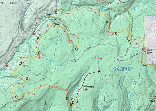 Purple dots are route of the loop. C=camping. Blue dots are waterfalls. Unblazed trail location on map is approximate and is not a gps track.
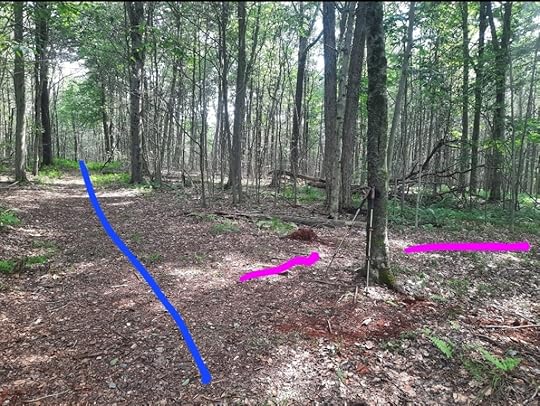 Point A going clockwise. Blue is Cherry Ridge Trail. Purple is the unblazed, established trail.
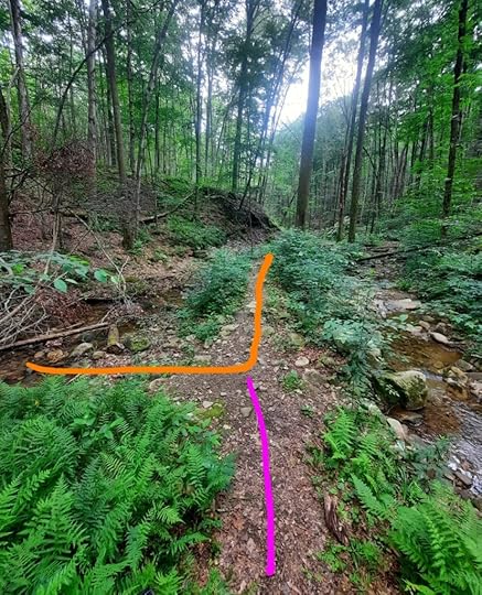 Point B going clockwise. OLP is orange, unblazed trail is purple. It is along Long Run.
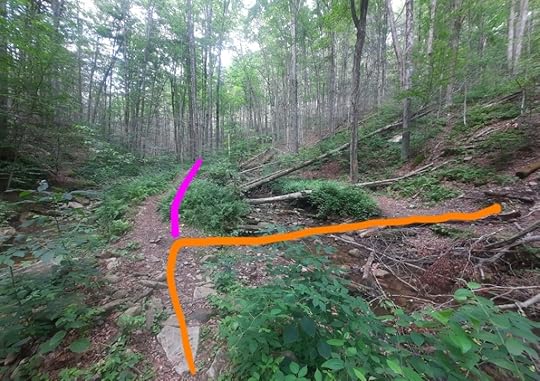 Point B going counterclockwise. This juncture is obvious. OLP is orange, unblazed is purple.
View this post on InstagramA post shared by Jeff Mitchell-Outdoors Author (@hiking_mitch)
View this post on InstagramA post shared by Jeff Mitchell-Outdoors Author (@hiking_mitch)
View this post on InstagramA post shared by Jeff Mitchell-Outdoors Author (@hiking_mitch)
View this post on InstagramA post shared by Jeff Mitchell-Outdoors Author (@hiking_mitch)
View this post on InstagramA post shared by Jeff Mitchell-Outdoors Author (@hiking_mitch)
View this post on InstagramA post shared by Jeff Mitchell-Outdoors Author (@hiking_mitch)
View this post on InstagramA post shared by Jeff Mitchell-Outdoors Author (@hiking_mitch)
View this post on InstagramA post shared by Jeff Mitchell-Outdoors Author (@hiking_mitch)
Jeff Mitchell's Blog
- Jeff Mitchell's profile
- 3 followers


