WHERE ONCE THERE WAS A PUB IN HAMPSTEAD THERE IS NOW A SUPERMARKET
HAMPSTEAD IS RICH in historical curiosities. One of them is an unexceptional little road that has an interesting story.
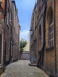
Just south of Tesco’s supermarket (the former Express Dairy) on Hampstead’s Heath Street there is a narrow cul-de-sac called Yorkshire Grey Place. It enters Heath Street across the road from The Horseshoe pub and Oriel Place. I have often wondered about this short, uninviting blind-ended lane and its history. Just under 50 yards in length, it runs west from Heath Street.

At long last, I began looking on the Internet for some history (if any) of this bleak little roadway lined on both sides with high buildings. It gets its name from a pub that used to exist near it – The Yorkshire Grey. The pub was already in existence by 1723, but was demolished in the 1880s (https://londonwiki.co.uk/Middlesex/Hampstead/YorkshireGrey.shtml) – in 1886, according to FE Baines in his “Records of Hampstead” (publ. 1890). An online history of Hampstead (www.british-history.ac.uk/vch/middx/vol9/pp15-33) provided the following information about the pub and its surroundings:
“North of Church Row the Yorkshire Grey had been built by 1723 and cottages called Evans Row probably faced it c. 1730. In 1757 the inn and 14 houses occupied by a brickmaker, clockmaker, carpenter, apothecary, and others were ‘late freehold’ but in 1762 they were described as copyhold (one alehouse, two houses, and 11 cottages).”
This area was one of the slums of Hampstead – it was devoid of water supply and drainage.
During the planning and construction of Fitzjohns Avenue, which began in 1875 and was only completed by about 1887, there was some discussion about whether it should end on the High Street or give direct access to the road up to Hampstead Heath. Prior to the late 1880s, the recently built Avenue stopped south of Hampstead village. Its route from there into the centre of Hampstead village was subject to some controversy. This was described in “Hampstead, Building a Borough 1650-1964” by FML Thomson, as follows:
“… The shopkeepers in the High Street feared loss of trade if any traffic was diverted to a new route, and held out for a scheme which would debouch Fitzjohn’s Avenue into High Street at the King William IV ; while the gentry wanted the direct route to Heath Street and the Heath, arguing that this gave a bit of slum clearance of Bradley’s Buildings, Yorkshire Grey Yard, and Bakers’ Row as a bonus. The dissension continued when the scheme was revived with a number of public meetings in 1881, dominated by the gentry element which was increasingly exasperated at having its carriages bottled up in Fitzjohn’s Avenue without any proper exit.”
As it turned out, the “gentry element” had their way, and the slum clearance that affected Yorkshire Grey Yard was carried out – the pub disappeared as a result. In relation to this, the online history of Hampstead, already quoted revealed:
“In 1883 the Metropolitan Street Improvement Act authorized redevelopment of the whole area at the joint expense of the local authority and M.B.W. In 1888 High Street was widened, Fitzjohn’s Avenue (then Greenhill Road) was extended to meet Heath Street, and soon afterwards Crockett’s Court, Bradley’s Buildings, and other slums, including Oriel House and other tenemented houses, were replaced by Oriel Place, shops, and tenement blocks.”
The pub has long gone, but I managed to find two pictures depicting it. One is a painting showing the place in about 1863 (https://artuk.org/discover/artists/lester-harry). It was the work of Harry Lester. The other is a black and white photograph in the book by FE Baines, which was published a year after the pub was demolished. A detailed map surveyed in 1868 showed that the pub was quite a large building with a substantial yard next to its east facing façade. To its west, the yard opened on Little Church Row (now part of Heath Street). This and a blind-ending road called Yorkshire Grey Yard are shown on the map. Immediately south of the pub, there was another cul-de-sac running from east to west – it was unnamed. I believe that this is what is now called Yorkshire Grey Place.
The map drawn in 1868 shows the layout of the area around today’s branch of Tescos before Fitzjohn’s Avenue was conceived. Another map drawn in 1915 shows how the topography of the area changed following the completion of the Avenue. The Yorkshire Grey pub existed before the nearby, still existing, Horseshoe pub was established – it appears on the 1915 map. Originally named ‘The Three Horseshoes’, it moved from Hampstead High Street to its present address in 1890. Had the Yorkshire Grey pub survived, it would have been about 110 feet away from the Horseshoe.
Once again, wondering what is in a name – in this case Yorkshire Grey Place – has opened my eyes to an interesting bit of the history of Hampstead. Finally, it is interesting to note that the Victorian building that houses Tesco’s was built in 1889 – three years after the Yorkshire Grey pub was demolished to make way for buildings along the northern continuation of Fitzjohns Avenue. So, next time you are queuing to pay in Hampstead’s Tesco, remember that you are standing on land where once the patrons of the Yorkshire Grey once trod.
You can read much more about Hampstead and its surroundings in my book, which is available from Amazon:
https://www.amazon.com/BENEATH-WIDE-SKY-HAMPSTEAD-ENVIRONS/dp/B09R2WRK92/


