Backpack the Susquehannock/West Branch Trail Loop-Susquehannock State Forest
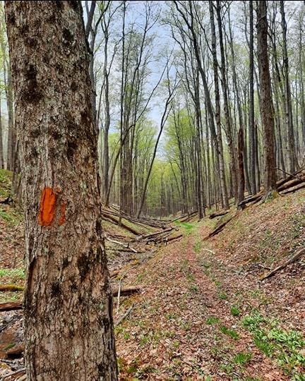 Susquehannock Trail
Length: 25 mile loop
Difficulty: Easy to moderate
Parking: There are numerous places to park. I parked at pull off parking on Lyman Run Road, just west of Lyman Run State Park. 41.721934, -77.785968
Direction of description: Counterclockwise from Lyman Run Road
Terrain: Mostly level and rolling with gradual climbs and descents. Terrain south of Lyman Run is the steepest.
Trails maintained by: Susquehannock Trail Club
Trail conditions: The Susquehannock Trail System (STS) is well blazed and in good condition. It has mile markers. The West Branch Trail (WBT) is brushy, has some blowdowns, and faded blazes (these may be corrected soon). The STS is a very smooth trail with few rocks or even roots. The WBT is not as well established, but can be followed.
Blazes: STS is orange. WBT is red and yellow.
Camping: This loop has the Sunken Branch Shelter and a small hut, the Dynamite Shed. Best campsites are at Lyman Run and Palmatier Hollow. There’s also a good campsite on the WBT, in the creek west of Captain Shelton Trail.
Highlights: Isolation, scenic streams, open woodlands, wildflowers, a few beautiful campsites, Sunken Branch Shelter, Dynamite Shed, a few minor views, Peak-A-Boo Vista. I think the most unique thing about this hike are the extensive views over meadows, beaver ponds, and dams along the WBT where you can expect to see a lot of birdlife.
Issues: WBT has brush, faded blazes that can be far apart, and some fallen trees. There are some navigational issues hiking the WBT from west to east. Due to the extensive meadows, expect sun exposure on warm days. The WBT can be followed, but it will be slower going than the STS. I think the scenery of the WBT makes it more than worth it.
Description: This loop is a hidden gem of Pennsylvania backpacking. I thoroughly enjoyed it. The terrain is forgiving, the trail is often smooth, and the forests, creeks, and beaver meadows make for a great experience.
There are views on this trail, but not the kind you might expect. Don’t expect big views like on the Black Forest Trail. Instead you will be treated to views over meadows, ponds and beaver dams. This is great for observing wildlife, seeing flowers, or fall foliage. On the WBT, these views are almost nonstop. You will hike a narrow, isolated valley with views of the ridges and plateaus that rise over you.
I began on Lyman Run Road where there is space for pull off parking. I started there because that puts the best camping at Palmatier Hollow, or the Sunken Branch Shelter, about halfway along the loop. There are many places to start and almost all road crossings have a place to park.
I followed the STS gradually up Jacob Hollow, a scenic valley, with open woods where I could see deep through the trees. There was one campsite, but it was small. I enjoyed hiking along the small creek. Near the top, cross some ATV trails which look like dirt roads. The STS then levels on the plateau with some beautiful forests. A small climb to a ridge offers a view to the south and a side trail leads to a north view. Both views are minor.
The smooth trail continued through the forest, passing cross country ski trails. There is an extensive trail system here besides the STS. I reached the start of the STS loop and a trail register. I then began hiking south on the STS through more woodlands and down another beautiful valley. I hiked in Spring and there were many wildflowers, such a red trillium, squirrel corn, dutchmans breeches and trout lilly.
The STS follows Splash Dam Hollow with several beaver dams, ponds and meadows. It is a taste of what is to come on the WBT. Reach the best camping on the loop at Palmatier Hollow, between miles 80 and 81 on the map. There are two sites under hemlocks. The one downstream is particularly beautiful.
Now climb up another valley along a small stream. Pass a small meadow with some old apple trees, indicating an abandoned homestead. The climb steepens a little and crosses Sunken Branch Road. Descend to Sunken Branch Shelter, a very nice spot that can sleep 4 or 5. There is no water at the shelter, so be sure to bring some with you. The shelter has some amenities like chairs and a table. Sometimes members of the Susquehannock Trail Club bring jugs of water to the shelter, but don’t rely on that.
Descend into a scenic valley with streams and springs. Begin a slight climb into another valley and reach a sign for the WBT and a trail register. Turn left on the WBT and leave the STS. The WBT has yellow and red blazes, although I’m told the trail will be red in the future. You will notice the blazes are spaced far apart, but the trail is followable along an old grade. Soon, the beaver dams and meadows appear. If hiking east on the WBT, there are two navigational issues. About a half mile from the STS, the WBT makes a discreet left turn across a meadow (the Problem Meadow on the map) so keep an eye out for that. The WBT then reached a dirt road (ATV trail) and crosses the creek. Here it is easy to continue on the Beech Hollow Trail, but be sure to make a hard right on the WBT along the creek.
The next three or four miles on the WBT offer some unique hiking. The trail stays on the bank above beaver dams, ponds and meadows, offering extensive views. There a wildflowers and lots of birds. I really enjoyed it. The trail has better blazes and is followable, but it is brushy and there were blowdowns. The valley becomes deeper and more isolated. The beaver dams and ponds become larger, with one covering a few acres. It reminded me of the meadows of Quehanna, except set in a deep valley. I couldn’t help but to stop and look at the scenery. If you love meadows, this is your hike. Despite the very forgiving elevation profile of the WBT, it will take you longer to hike it than you might expect.
The WBT has one good campsite, in a hollow west of the Captain Shelton Trail. As you hike east, the trail becomes more wooded, but there are still meadows and beaver dams. Cross an old concrete bridge with a register and reach West Branch Road. Turn left on the road and walk it for .6 mile. The STS joins, turn left on Sunken Branch Road and then follow the STS right into the woods. Climb gradually to the unique Dynamite House, a historic CCC dynamite shed that was turned into a small hut for hikers. There is some space for a tent.
Continue the climb up the scenic valley. The trail levels across the plateau with forests of hemlock and hardwoods. Cross a dirt road (ATV trail) and continue along the plateau. At the second dirt road, turn left and hike a few hundred feet to Peak-A-Boo Vista, offering a fine view of Lyman Run State Park. Return to the STS and make a steep descent. Pass some springs and reach beautiful Lyman Run. Cross a bridge and some fine campsites. Cross another bridge and reach the end of the loop at Lyman Run Road.
This is a great loop for those who want isolation, great camping, good scenery, and wildlife without killing yourselves. Hopefully more hikers will visit the WBT to help keep that unique and beautiful trail open. The entire STS could use more hikers, hike somewhere different and help support the Susquehannock Trail Club.
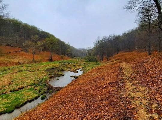 West Branch Trail
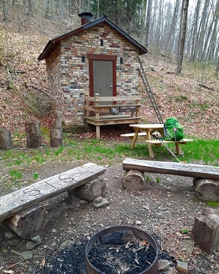 Dynamite House
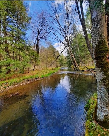 Lyman Run
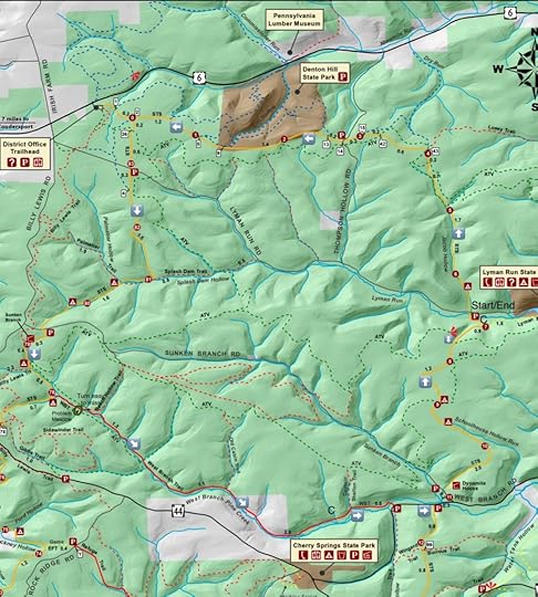 C are also campsites.
More photos:
View this post on InstagramA post shared by Jeff Mitchell-Outdoors Author (@hiking_mitch)
View this post on InstagramA post shared by Jeff Mitchell-Outdoors Author (@hiking_mitch)
View this post on InstagramA post shared by Jeff Mitchell-Outdoors Author (@hiking_mitch)
View this post on InstagramA post shared by Jeff Mitchell-Outdoors Author (@hiking_mitch)
View this post on InstagramA post shared by Jeff Mitchell-Outdoors Author (@hiking_mitch)
View this post on InstagramA post shared by Jeff Mitchell-Outdoors Author (@hiking_mitch)
View this post on InstagramA post shared by Jeff Mitchell-Outdoors Author (@hiking_mitch)
View this post on InstagramA post shared by Jeff Mitchell-Outdoors Author (@hiking_mitch)
Jeff Mitchell's Blog
- Jeff Mitchell's profile
- 3 followers


