Fantasy Maps Are Missing Something
Maps are great. Maps in books are even better. Having that visual guide to the geography of strange new worlds is a marvellous thing when it’s done well.
But something I’ve come to realise is that even the best fantasy maps are missing something very, very important.
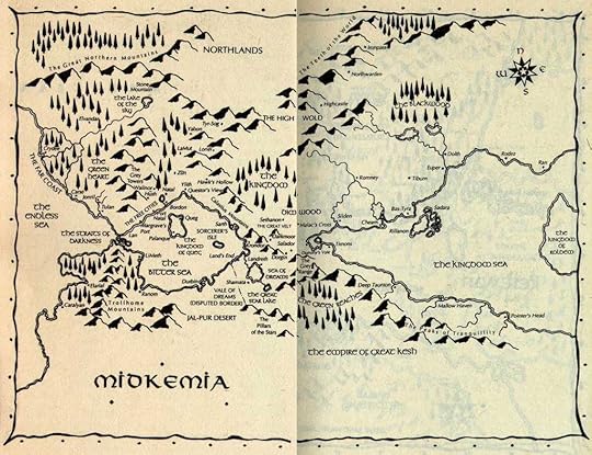
Example number one: the map of Midkemia from Feist’s Riftwar books.
 Copyright, of course, is Raymond E. Feist’s.
It’s pretty good. The Kingdom of the Isles has loads of cities, great and small, all labelled, and as there are so many books in the Riftwar saga and therefore so much travelling, most of them get visited or mentioned at some point. The geography of trade and commerce is important; towns are built along strategic roads, ports in good anchorages – the workings of entire nations rationalised around this geography. It’s a damn good map. But it’s not quite there yet.
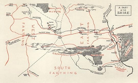
But for the comparison that best makes my point, we can look at Tolkien’s map of Middle-Earth – probably one of the most famous fictional maps ever drawn. Those sweeping mountain ranges, those esoteric place-names, the carefully plotted rivers and routes – it’s a masterpiece, and given the nature of the journeys in The Lord of the Rings, it’s very helpful that it is so detailed. But again, it’s missing something very important. And to show you what, let’s zoom in on the Shire, where it all begins.
 And this of course belongs to the Tolkien Estate.
The distance from Hobbiton to Bree is, according to some hasty research, about 120 miles. The whole Shire is about 300 miles across, which is roughly the size of Wales. In all that space, there are, according to the map, a handful of settlements. In the book many more are of course mentioned – about 30 or so different little towns and villages.
Now let’s look at a real map. Let’s look at Herefordshire, which is where I grew up – and which is also, conveniently, one of the Midland counties on which the Shire is based, along with neighbouring Shropshire and Worcestershire. (Yes, I grew up in the Shire, I am small, eat too much food and have big hairy feet; I am literally a hobbit.) This is a map from the 1800s – it hangs on my wall right above my desk.
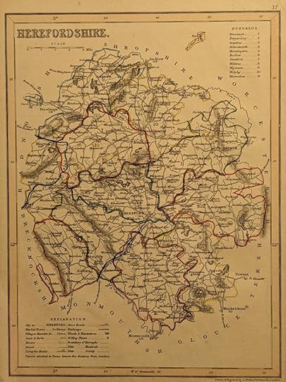
There are dozens of place-names there. Twice, maybe three times as many as the Shire at least, from Pembridge to Tenbury to Little Dewchurch. Tiny hamlets, hefty towns, villages that have been there since the Domesday Book. There are probably more than twice as many place-names in this single county of the U.K. than there are in the whole Shire that is based on it – and which, as previously mentioned, is something like ten times as large. And that’s just one county in a whole country in a whole world – one county whose number of named settlements is more than all those on the maps of Midkemia and Middle-Earth combined.
Now of course, the aforementioned fantasy maps are huge in scale. They’re mapping entire continents or countries, where this detailed map of a single county can afford to list every single village. Our modern world maps only show major cities and settlements too; it’s a necessary concession to matters of scale. But even if you don’t show it on the map, you have to remember that all these little towns are still there in the book. The Riftwar does this fairly well, mentioning many little villages and the like on characters’ travels from City-On-The-Map #1 to City-On-The-Map #2. But there’s still a lot of blank space out there, especially to the east – space where there should be towns, visible even at this scale, and they’re not there. Tolkien mentions his villages in the Shire, but how many other towns have the elves got? How many human cities get mentioned beyond Edoras, Minas Tirith and Osgiliath? Yes, I’m sure there are plenty, but my point is that it’s not enough. Look at that huge, empty space in Enedwaith – there must be people there. Or if not, there must be a reason why not…
And I’m guilty of this too. My one published map might be of a pretty small island, but it’s not that small – there should probably be more than two or three towns on the Corpus Isles. I excuse my geography in Ad Luna because, y’know, they’re on the Moon, and so sticking almost everyone in one big sci-fi mega-city is, I think, forgiveable. But the Corpus Isles of the Boiling Seas should be better populated if it’s to be realistic. When I’m drawing up the maps for book 3 (yes, there are going to be some), I’m going to have to remember that.
The point(s) I’m making is, essentially, that there’s got to be far more to a fictional world than what you can easily show on a map. Even if you don’t draw it, you’ve got to account for it. And so when you’re sketching out your vast expanses of rolling countryside and dotting in maybe three cities, consider all the other places people would be living – and maybe add a few more dots and names to your landscape.