Climbing above 13,000 feet on Mt. Audubon
This article is about my climb of Mt. Audubon with information to help you climb your next high peak.
While working on a Monday afternoon my mind started drifting away from work. I felt like I was in a mental fog brought on by the never-ending COVID pandemic and other things happening in my life. The only and best cure I’ve found for this is to go hiking or climbing in the mountains. So, I decided to wrap up my work by 1:30 pm and drive up to the Mount Audubon trailhead for a climb.
Mount Audubon stands 13,223 feet (4030 m) high. It is a Thirteener. It is the 459th highest peak in Colorado out of over 5,000 mountains. With all the emphasis on climbing Fourteeners, I’ve found Thirteeners to be much less crowded. In fact, I was the only person on Mt. Audubon during my climb. That was primarily because I started late in the day at 3:44 pm.
The photos look hazy because of smoke from wildfires to the west. The wind has predominately been from the west for the past several days. This is a moderate hike/climb for experienced hikers and a difficult hike/climb for people who normally hike on flatter trails for shorter distances. The climb requires ascending 2,712 feet in 3 miles – that is a lot of vertical gain. The trail includes a wide range of surface conditions, which you can see in the photos below. You should set a turn-around time so you can get back down before dark. This is great practice for climbing Fourteeners.
 Informational signs at the trailhead. Starting elevation at 10,500 feet.
 The gear that I hiked with is similar to the gear highlighted in this blog: https://tjburr.wordpress.com/2021/04/16/gear-for-a-hike-of-1-4-hours-or-3-10-miles/.
Make sure you have comfortable socks and shoes. My favorite socks are Darn Tough mountaineering socks made in Vermont, USA. They are durable, over-the-calf socks with a lifetime warranty. I’ve sent four pair back to them with holes in the heels. The company replaces them with new ones. My favorite hiking boots are Salomon Quest 4D 3 GTX. I have neuropathy in my feet, which is nerve damage. Without these comfortable socks and boots, hiking for me is painful.
My favorite pants are KÜHL Klash Pants. They have everything that I like in hiking/climbing pants. All the pockets are zippered to secure your belongings. There is a pocket that my phone slips right into and another one for a wallet. They are so comfortable that I don’t feel like I’m even wearing pants. They are also durable and have good abrasion resistance.
 Trail sign and warnings about mountain lions.
In addition to mountain lions, what other possible dangers are there on this hike?
It is always good to do a risk assessment of your hike or climb to double check your preparedness. For this hike the possible dangers include lightning, rock fall, bears, exposure, fatigue, dehydration, loose rocks, tripping, and altitude sickness. For most of these, you need to recognize the symptoms and know what to do. Be aware of your surroundings, including the sky.
 The route and elevation profile. Near the top some portions of the route have a slope of over 40%, which equates to a rise of 40 feet in 100 feet horizontal.
 This is what the trail looks like after about 14 minutes of hiking.
 A beautiful pine forest. A couple on their way down asked me if they were getting close to the parking lot. I said “yes.” I knew how they felt. Sometimes the descent feels like an eternity when your feet hurt, and you are low on energy.
 Farther up the trail at 4:03 pm.
 View of Brainard Lake from the trail.
The following photo shows the approximate route that I took the first time I climbed Mt. Audubon when I was a teenager. My parents were fishing at Brainard Lake. I told them I was going for a hike. Four or five hours later I returned.
 The cross-country route I took as a teenager. Not recommended.
 A view from a switchback on the trail shows Mitchell Lake, Pawnee Peak (12,943 ft) connected to Mt. Toll (12,979 ft) via the big saddle.
 Continuing upward I passed some wildflowers and noticed the trees getting shorter.
There was a couple that I passed as they were going down. They said they hadn’t passed anyone else going up. I said, “That is awesome!”
At 4:26 pm I passed three guys and one girl on their way down. These were the last four people I would see on this hike including the return trip.
 The view ahead to the north at 4:24 pm. Nearing timberline.
It is getting a little harder to breath as I cross above 11,000 feet elevation.
 A few more minutes up the trail at 4:28 pm. Elevation: 11,340 ft.
 Fork in the trail at elevation of 11,400 feet. Beaver Creek is to the right and Mt. Audubon is to the left. 4:37 pm.
 The next photo shows the view when you turn to the left at the fork.
 View to left from the trail fork. Mt. Audubon is visible on the far left.
Still a long way to go. To some it looks like a barren wasteland. To me, it is freedom. Miles of land open, natural, and virtually untouched by people. It is the freedom of the mountains.
 Mt. Audubon is more visible from here.
At 4:53 pm, I see a large snowfield that helps feed Mitchell Creek with water all through the summer.
 Looking south at 4:56 pm. The large peak with the flat top is Kiowa Peak.
The terrain is now alpine tundra. Trees do not grow at this elevation. This is also referred to as being above timberline.
 Higher on the trail at 5:06 pm the snowfield is closer.
Some dark clouds overhead with the potential to drop some rain on me. I’m optimistic since I had not heard any thunder. I also have a rain parka in my small hydration pack (7 lbs). My hydration pack is the original CamelBak HAWG, which I’ve used for 20+ years.
 Marmots along the trail.
Two marmots look around with some concern as I approach their home that is beside the trail. There aren’t many year-round residents at this elevation . . . mostly marmots and pikas.
 This large snowfield with ice will last through the summer.
The dark sky at 5:08 pm. These clouds moved in quickly and left quickly. If it had been a thunderstorm, I would find a low dip in the terrain, put on my rain parka, and assume the position. The position is squatting down but keeping my feet flat and against each other. This is not a good place to be in a thunderstorm. It is too exposed. However, an even worse place to be in a thunderstorm would be up on the ridge or on the summit.
If you are wondering why the snow looks dirty it is because the wind carries dust, which drops when the wind slows down.
 View to the southeast from the trail.
At 5:14 pm, this is the view looking back and to the southeast. Brainard Lake and Lefthand Reservoir are visible on the right side. Unfortunately the visibility is limited because of the wildfire smoke in the air.
 Slowly, but surely getting closer to Mt. Audubon’s summit.
Rough and rocky section of trail with the summit in sight at 5:20 pm. Elevation: 12,040 ft. Flip flops and sandals are not recommended for this trail. Buy the best hiking boots you can afford. On one adventure, my friend, Craig, and I hiked over Pawnee Pass. Craig wore old running shoes with the soles starting to come apart. He didn’t want to spend the money to get some hiking boots. He was also a minimalist who always tried to get by with what he had. Neither of us could afford quality gear. I had hiking boots, but they were leather and heavy (2 lbs each).
 Mt. Audubon is straight ahead.
At 5:29 pm and an elevation of 12,240 feet, the summit is straight ahead. The trail doesn’t go straight though.
 View east toward the Great Plains. The view is much better on a clear day.
At 5:43 pm and an elevation of 12,450 feet, I briefly left the trail to look at this spring, which is part of the headwaters of Mitchell Creek. The view is looking east toward the Great Plains. If the sky hadn’t been smoky, the Great Plains would be clearly visible from here.
 View to the north toward Rocky Mountain National Park.
In the middle of this photo in the distance is Longs Peak (14,259 ft) with the distinctive flat summit and Mt. Meeker (13,911 ft, 68th highest mountain in Colorado) to the right of it. Back when I was 32 years old, a friend and I climbed Mt. Meeker and Longs Peak in one day.
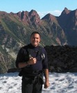
 Selfie of the author feeling like he is in Heaven.
This is me at 12,720 feet at 6:01 pm. Of course, I wanted Longs Peak to be in the background. It is my favorite mountain in Colorado. I grew up on a small place in the country out on the Great Plains. From there, Longs Peak is the highest, most prominent mountain visible. Nearly every day of my childhood and teenage years I would look at Longs Peak. At one time in my childhood I didn’t think it was possible to climb such a mountain.
Native Americans were probably the first to climb Longs Peak. The referred to Longs Peak and Mt. Meeker as the two guides. It would have been an incredible sight for any of the early visitors to the area. Major John Wesley Powell and his team made the first recorded climb of Longs Peak in August 1868. It is one of Colorado’s most difficult and deadly of the peaks over 14,000 feet (Fourteeners).
 This is the view of the summit from 12,720 feet.
Breathing is more difficult, and the trail is harder to find. From here, you keep climbing until you can’t climb any higher. It is best to stay on the trail as much as possible. Many of these boulders are loose and teetering on one another. This is a place where you could dislodge a rock onto yourself and get pinned down or worse. The rock is also angular with sharp edges that cut into your shins if you slip. The trail may be longer in length, but it is the safer route.
We often hear that there is less oxygen at higher elevations, which is false. The air contains about the same 21% of oxygen at 14,000 feet as it does at sea level. The air we breathe is 78% nitrogen. It is harder to breath because the atmospheric pressure is much lower. At sea level, the atmospheric pressure is 14.7 psi. At 14,000 feet it is 8.6 psi. In simple terms, when you have more pressure pushing the air into your lungs, it is easier to breath. With less air pressure you have to work harder to inflate your lungs. Even at 12,000 feet I was breathing more rapidly than I was at 5500 feet when I left home. On the summit of Mount Everest (29,029 ft), the air pressure is only 4.6 psi. Without supplemental oxygen at that elevation, it is impossible for your body to get enough oxygen.
 The highest point on Mt. Audubon is in sight.
At 6:30 pm I am two minutes away from the summit. Do you see why these are called the “Rocky” Mountains? This was the time I had planned to turn back if I hadn’t made it to the summit yet. I carry a headlamp with me, but I much prefer hiking in natural light. I’m not as hard core as I used to be. When I was younger I would plan on hiking back in the dark to make the adventure more challenging.
 View to the north from the top of Mt. Audubon. These mountains continue on into Wyoming.
This is the view north from the summit at 6:32 pm. This was the fourth time I had climbed Mt. Audubon (13,223 ft).
 View to the south. These mountains stretch south into New Mexico.
This is the view looking south with nearly all the Indian Peaks in sight. Mount Toll (12,979 ft) is the distinct summit on the right side. I climbed Mt. Toll when I was 19 years old.
 Panoramic view from the summit.
 The top three reasons that I climb are 1) the feeling of self-achievement, 2) the euphoria, and 3) the incredible scenery from up high. Being up high in the mountains gives me a euphoric feeling . . . a natural Rocky Mountain High.
 The long and winding trail back.
Looking at the long trail back was disheartening. How am I going to get back before dark? It looks like the trail stretche forever.
 Columbine flowers along the trail back.
It isn’t dark yet.
 Such beautiful flowers.
The Columbine is the Colorado State flower.
 Kiowa Peak to the south, another Thirteener.
A view from a gap in the forest at 8:04 pm. The highest mountain to the left is Kiowa Peak. Niwot Ridge is barely visible in front of Kiowa. The foremost ridge separates the South St. Vrain Creek drainage from the Mitchell Creek drainage.
 The sign at the trailhead – the starting line and the finish line.
I made it back to the trailhead at 8:26 pm. It was just getting dark enough to require a headlamp.
 Jeep Grand Cherokee Laraedo, my home away from home.
My total hike was 7.78 miles, but I hiked a lap around the parking lot to get my daily mileage to over 8.0. My Jeep was the last remaining vehicle at this trailhead. I would like to have stayed the night right here, but I had to get back for work the next day. I’m seldom in a hurry to leave the mountains.
 The Indian Peaks at nightfall.
My last view of the Indian Peaks for this day. Mount Audubon is the rounded mountain on the right side. Mount Toll (12,979 ft) is in the middle with a ridge connecting to Paiute Peak (13,012 ft) to the left of Audubon.
This is where I caught the mountaineering bug. My parents brought me here on a fishing trip when I was a child. This was the most amazing place I had seen at that time of my life.
__________________________________________________________________________________
The narrative of my first climb of Mt. Audubon is in Chapter 2 of my book, Rocky Mountain Adventure Collection. It is available from Amazon.


TJ Burr, Rocky Mountain Adventures & Insights