
Vague and Unrecognized Maps of New Mexico
New Mexico had already been settled by Europeans for 314 years when it became the 47th state of the United States on January 6, 1912. During that long period, New Mexico’s borders changed repeatedly as Spain, France, Britain, United States, Mexico, Texas, and the Confederate States of America vied for control.Often, no one agreed on where the borders actually were.  Mexico or New Spain, published in London in 1777. Note that New Mexico is written across a vast, uncharted area above Mexico and the land between it and Louisiana is called “Great Space of Land unknown.” Courtesy Fray Angélico Chávez History Library. Spain laid claim to a vast area of North America when it established its New World empire in the 16th century. Most of what is now the central and western United States, including Arizona, Colorado, Utah, Texas, New Mexico, and beyond was called New Mexico. As Spain focused on settling Mexico and South America, the north remained unexplored, its boundaries undefined. In 1598, King Felipe II sent Juan de Onate, his soldiers and their families north, to establish a colony in the middle of New Mexico. Located in the upper Rio Grande, their missions were to pacify and convert the Indians and to discourage other Europeans, particularly the French, from settling their northern territories. The French threat ended after France’s defeat in the French & Indian Wars, when Louis XV ceded all of the Louisiana territory, except New Orleans, to Spain, who returned it to France some forty years later when Napoleon demanded it. Napoleon had promised that the land would never be sold to a third party, but he did exactly that a year later, selling it to the United States.
 Spain’s possession of Texas was uncontested until the United States purchased the Louisiana Territory in 1803. The U.S. claimed the Purchase included all the land between New Orleans and the Rio Grande including most of the New Mexico settlements. Spain claimed that New Mexico and Texas extended to the Missouri River, encompassing land all the way to present day Montana. Since the U.S. had no presence on the Rio Grande and Spain had none along the Missouri, neither country could enforce their claim. New Mexico’s Governor Fernando Chacon tried to force back Lewis and Clark’s expedition to chart the west, but hostile plains Indians drove him back. He did, however, manage to capture Lieutenant Zebulon Pike and his band of explorers in what is now southwestern Colorado in 1806. Pike and his men were treated well, and after a year’s interrogation were released in New Orleans.
When Mexico declared independence from Spain in 1821, it instituted two policies that increased American presence n New Mexico. First, it allowed trade along the Santa Fe trail.
Spain had forbidden New Mexico to trade with anyone but Mexico. Now Americans brought their influence, along with wagon trains full of goods and supplies from Missouri. Those merchants who settled in New Mexico and became influential in local society and politics. The Bent Brothers put their trading fort on the east bank of the Arkansas River in what is now Colorado because that river was the northeastern border of Mexican territory at the time.
The second decision the Mexican government did was invite Anglo-Americans to settle in the part of the territory known as Texas beginning in 1824. In less than a decade, Americans far outnumbered Hispanics in Texas. They never assimilated into the local culture and won independence in 1836. Mexican authorities never formally acknowledged the Republic of Texas, which claimed territory all the way to the Rio Grande.
 Map published in Philadelphia in 1847 shows Texas’ extending to the east bank of the Rio Grande. Courtesy Fray Angélico Chávez History Library. But the Texans were not the only people trying to grab land from New Mexico. Soon after Brigham Young led the Mormons west to the Salt Lake Basin, he petitioned Congress to create a new state for his people. His proposed state, Deseret, included a bit of California coastline and nearly the entire western half of New Mexico. Instead, the federal government created a much smaller state and named it after the Ute tribe.
 Map from Lost States: True Stories of Texlahoma, Transylvania, and other States That Never Made It, by Michael J. Trinklein. In 1861, Confederate Lieutenant Colonel John Baylor brought his 2nd Texas Cavalry Regiment into New Mexico. He split the territory in two horizontally, creating a Confederate Arizona in the south and a Union New Mexico in the north. This map was never acknowledged by the Union States.
 New Mexico became a U.S. territory after the Mexican American War. It fought off a Confederate invasion during the Civil War. However, it languished as a territory for decades. One reason was its name, which remains a confusion to many. In 1887, local leaders suggested switching the territory’s name to Montezuma in the hopes that it would no longer be assumed to be part of the country to our south. The also proposed renaming the territory Lincoln, but an association with the Lincoln County Wars made that inadvisable.
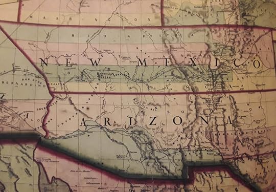
 Map from Lost States: True Stories of Texlahoma, Transylvania, and other States That Never Made It, by Michael J. Trinklein. When New Mexico finally did enter the Union as a state, it was very much reduced in size. It's western half became the state of Arizona, and its east was Texas. Large portions of its northern border are now part of Colorado. And still there are countless people who don't know where New Mexico is and what country claims it. A native New Mexican, author Jennifer Bohnhoff isn't quite sure where she is most of the time. While her latest book Where Duty Calls is set in New Mexico during the Civil War, she is currently at work on a book about the Folsom people, who lived in New Mexico 10,000 years ago. Unfortunately, they left no maps.
Mexico or New Spain, published in London in 1777. Note that New Mexico is written across a vast, uncharted area above Mexico and the land between it and Louisiana is called “Great Space of Land unknown.” Courtesy Fray Angélico Chávez History Library. Spain laid claim to a vast area of North America when it established its New World empire in the 16th century. Most of what is now the central and western United States, including Arizona, Colorado, Utah, Texas, New Mexico, and beyond was called New Mexico. As Spain focused on settling Mexico and South America, the north remained unexplored, its boundaries undefined. In 1598, King Felipe II sent Juan de Onate, his soldiers and their families north, to establish a colony in the middle of New Mexico. Located in the upper Rio Grande, their missions were to pacify and convert the Indians and to discourage other Europeans, particularly the French, from settling their northern territories. The French threat ended after France’s defeat in the French & Indian Wars, when Louis XV ceded all of the Louisiana territory, except New Orleans, to Spain, who returned it to France some forty years later when Napoleon demanded it. Napoleon had promised that the land would never be sold to a third party, but he did exactly that a year later, selling it to the United States.
Spain’s possession of Texas was uncontested until the United States purchased the Louisiana Territory in 1803. The U.S. claimed the Purchase included all the land between New Orleans and the Rio Grande including most of the New Mexico settlements. Spain claimed that New Mexico and Texas extended to the Missouri River, encompassing land all the way to present day Montana. Since the U.S. had no presence on the Rio Grande and Spain had none along the Missouri, neither country could enforce their claim. New Mexico’s Governor Fernando Chacon tried to force back Lewis and Clark’s expedition to chart the west, but hostile plains Indians drove him back. He did, however, manage to capture Lieutenant Zebulon Pike and his band of explorers in what is now southwestern Colorado in 1806. Pike and his men were treated well, and after a year’s interrogation were released in New Orleans.When Mexico declared independence from Spain in 1821, it instituted two policies that increased American presence n New Mexico. First, it allowed trade along the Santa Fe trail.
Spain had forbidden New Mexico to trade with anyone but Mexico. Now Americans brought their influence, along with wagon trains full of goods and supplies from Missouri. Those merchants who settled in New Mexico and became influential in local society and politics. The Bent Brothers put their trading fort on the east bank of the Arkansas River in what is now Colorado because that river was the northeastern border of Mexican territory at the time.
The second decision the Mexican government did was invite Anglo-Americans to settle in the part of the territory known as Texas beginning in 1824. In less than a decade, Americans far outnumbered Hispanics in Texas. They never assimilated into the local culture and won independence in 1836. Mexican authorities never formally acknowledged the Republic of Texas, which claimed territory all the way to the Rio Grande.
Map published in Philadelphia in 1847 shows Texas’ extending to the east bank of the Rio Grande. Courtesy Fray Angélico Chávez History Library. But the Texans were not the only people trying to grab land from New Mexico. Soon after Brigham Young led the Mormons west to the Salt Lake Basin, he petitioned Congress to create a new state for his people. His proposed state, Deseret, included a bit of California coastline and nearly the entire western half of New Mexico. Instead, the federal government created a much smaller state and named it after the Ute tribe. Map from Lost States: True Stories of Texlahoma, Transylvania, and other States That Never Made It, by Michael J. Trinklein. In 1861, Confederate Lieutenant Colonel John Baylor brought his 2nd Texas Cavalry Regiment into New Mexico. He split the territory in two horizontally, creating a Confederate Arizona in the south and a Union New Mexico in the north. This map was never acknowledged by the Union States. New Mexico became a U.S. territory after the Mexican American War. It fought off a Confederate invasion during the Civil War. However, it languished as a territory for decades. One reason was its name, which remains a confusion to many. In 1887, local leaders suggested switching the territory’s name to Montezuma in the hopes that it would no longer be assumed to be part of the country to our south. The also proposed renaming the territory Lincoln, but an association with the Lincoln County Wars made that inadvisable. Map from Lost States: True Stories of Texlahoma, Transylvania, and other States That Never Made It, by Michael J. Trinklein. When New Mexico finally did enter the Union as a state, it was very much reduced in size. It's western half became the state of Arizona, and its east was Texas. Large portions of its northern border are now part of Colorado. And still there are countless people who don't know where New Mexico is and what country claims it. A native New Mexican, author Jennifer Bohnhoff isn't quite sure where she is most of the time. While her latest book Where Duty Calls is set in New Mexico during the Civil War, she is currently at work on a book about the Folsom people, who lived in New Mexico 10,000 years ago. Unfortunately, they left no maps.


No comments have been added yet.


