
Maps: A 17th-Century Korean View of the World
Tae Choson Chido, made circa 1874. Artist unknown. Geography and Map Division.
This is a guest post by Ryan Moore, a senior cataloging specialist in the Geography and Map Division. It first ran in the Library of Congress Magazine May-June 2021 issue.
Ch’onhado is a type of Korean quasi-cosmographical depiction that means “map of the world beneath the heavens.”
Koreans developed this view in the 17th century, and it remained popular until the 19th century. Scholars debate its origins but agree that the perspective is uniquely Korean. It exists in many iterations and often was included in atlases.
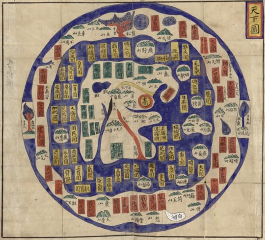
Sino-centricity is an essential element of the Cho’nhado.
In the Tae Choson Chido, above, China is front and center, shown as a red circle with a yellow interior. Korea — known as Choson — is a yellowed-bordered rectangle with a red interior. To its right is Japan, pictured as a yellow rectangle.
The proximity of these lands is relatively correct. The surrounding rings of land and sea, however, represent both real and mythological peoples and places, whose source was primarily classical Chinese literature.
Subscribe to the blog— it’s free! — and the largest library in world history will send cool stories straight to your inbox


Library of Congress's Blog

- Library of Congress's profile
- 73 followers

