
Interactive photos show what sea level rise in 30 major cities could look like
Climate change is impacting every part of life, from what we eat and what we drink, to wildlife and the natural landscape. And while prediction models vary, one thing has become painfully obvious over the past few decades: The world’s great cities are no exception to the list of things at risk by a higher average temperatures and more extreme weather events.
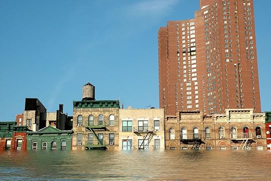
A new study and set of visualizations published by the independent organization Climate Central puts rising sea levels due to climate change into perspective. Using global elevation and population data, the researchers measured what cities would look like depending on the predicted increase. The model spans from where the world is at now to a worst case scenario of a 4 degrees Celsius rise in temperature and global mean sea level rise (the true rise in specific locations would vary greatly) of 8.9 meters (about 40 feet).
China, India, Indonesia, and Vietnam are the most at risk in this model, but they’re not alone. The researchers write that “at least one large nation on every continent but Australia and Antarctica would face exceptionally high exposure.” In all, at least one-tenth, and up to two-thirds, of the current population could be below the tide line in the coming centuries.
Countries and cities are handling the threat of rising sea levels and storms in different ways, from mangrove forests in Miami to oyster beds in New York City. The full extent is yet to be seen, but without action major cities around the world will become the proverbial frog in boiling water unable to get themselves out of a man-made mess.
BaltimoreBarcelonaBostonCape TownCopenhagenDubaiDublinHavanaHanoiHong KongHonoluluLagosLisbonLondonLos AngelesMumbaiNaplesNew YorkOsloPhiladelphiaPuerto VallartaRio de JaneiroSan FranciscoShanghaiSydneyTampaTokyoTunisVancouverWashington DC 


Matador Network's Blog

- Matador Network's profile
- 6 followers

