Explore Falls Creek and Long Valley Run-SGL 36

This hike explores impressive waterfalls and giant rocks. It is largely off trail and should only be attempted by experienced hikers. The Schrader Creek valley is a remarkable place to explore, with many waterfalls, views, giant rocks, mines, and other ruins from the mining era. Schrader Creek itself has many whitewater rapids and attracts paddlers when the water is high. It is a special, and relatively unknown, area.
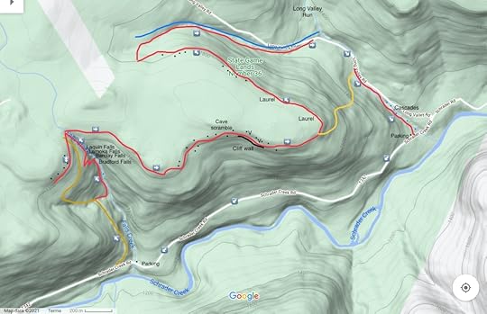
For this hike, park near Long Valley Run, as that parking area is larger. If you don’t have two cars for a shuttle, walk Schrader Creek Road to Falls Creek. Cross the bridge over Falls Creek and continue on Schrader Creek Road for a short distance. Turn right onto an old forest road (brown on the map) with an established footpath. Hike up it. Cross a side stream and reach a meadow. Leave the old forest road and follow a trail down to Falls Creek. Enjoy all the falls and cascades. It is a beautiful creek. Hike up the creek to see more waterfalls. Enter a gorge and reach Bradford Falls, about 70 feet tall. This is an incredible falls. The old logs and stones that once cluttered the base of the falls have mostly washed away, making the falls even more scenic.
Now you must get around Bradford Falls; you can scramble up either side, but I usually go on the west side. Be careful as the terrain is steep. Above Bradford Falls is a gorge and scenic Barclay Falls, about 30 feet tall. Continue upstream to a gorge with cliffs and cascades. Reach Lamoka Falls, and above that, Laquin Falls. The hemlocks enhance the scenery along this already beautiful creek. Falls Creek is one of the finest waterfall gems in the Endless Mountains.
At the top we saw and old mine and headed west along the escarpment of the plateau, following a grade. There were large cliffs, rocks, and remnants of old mines. The graded faded into laurel and we turned around, returning to Falls Creek. We crossed the creek and walked through a hemlock forest, heading towards the escarpment. The laurel was moderately thick in places, but overall was not bad. We reached the escarpment, enjoying some large rock outcrops. We continued on, exploring more rocks and ledges, while finding passage through the laurel. I saw some large rocks above us, so we hiked up. There were giant boulders, and a cave we scrambled through. The scramble was a ton of fun. We explored more rocks and then went closer to the escarpment to enjoy a view through the trees.
Next was a hike on top of an impressive cliff line, it was beautiful with the pine and hemlocks. A bear path offered easier passage on top of the cliffs. I hope to return to explore the base of the cliffs. We reached another outcrop with a partial view, but three beautiful yellow phase rattlesnakes claimed it for themselves. We gave them a wide berth and moved on along the cliffs. The cliffs revealed some unique formations and chasms. We continued on, but the rocks became smaller and the laurel began to take over. We battled some laurel and saw more large rock outcrops and boulders. We reached an unnamed tributary of Long Valley Run and descended, passing small cascades. We reached a grassy road along Long Valley Run and walked down it. While this section was scenic, I’m not sure it was worth the effort. As a result, you might want to consider the yellow route on the map as a shortcut to the Long Valley Run Cascades.
Where the forest road crossed Long Valley Run, we went off trail and followed the creek downstream. While Long Valley Run does not have towering waterfalls, it does have an assortment of beautiful, unique cascades with bedrock that almost seems sculpted and polished. It was a highlight of this hike. The water was also a unique shade of translucent blue. The car and parking area were nearby. This hike is 6-7 miles long if you also hike the road.
Falls Creek and Long Valley Run are described separately in Hiking the Endless Mountains.
Parking is at 41.650020, -76.568232 for Long Valley Run, or 41.641295, -76.593426 for Falls Creek.
For the map above, brown is an old forest grade, red is off trail, black dots are large rocks and boulders. V is for vistas, which are partial views.
Photos:
https://www.instagram.com/p/CRpGTvzNdVv/?utm_source=ig_web_copy_linkhttps://www.instagram.com/p/CRaXkZ0N7VC/?utm_source=ig_web_copy_linkhttps://www.instagram.com/p/CRMJyffNrY6/?utm_source=ig_web_copy_linkhttps://www.instagram.com/p/CRK7R15tlBy/?utm_source=ig_web_copy_linkhttps://www.instagram.com/p/CRMLDQjtKEU/?utm_source=ig_web_copy_linkJeff Mitchell's Blog
- Jeff Mitchell's profile
- 3 followers


