Hike the Haystacks and Brook Kedron Loop-Loyalsock State Forest

The Haystacks have long been a popular hiking destination in the Loyalsock State Forest. For the more experienced and adventurous hiker, there is a great loop you can do along the unofficial Brook Kedron Trail. I’ve heard this may become an official trail, and it is shown on the Purple Lizard Map. When I hiked it, it was only marked with orange flagging. Be aware it can be a little hard to follow, especially south of Mead Road. Why hike Brook Kedron? It is a beautiful stream with many falls, slides, cascades, and a unique mini-gorge of fractured rock. It is a small stream; you can expect the best flow when the Loyalsock Creek is flowing over 3.0 feet on the USGS gauge. In summer, it will likely be dry except after a good rain. This loop is 5-6 miles long.
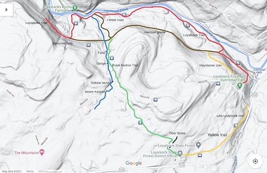
From the Loyalsock Parking area, just follow the Loyalsock Trail (LT) down to the old railroad grade and be sure to visit Dutchmans Falls. Continue on the Loyalsock Trail down the grade until the trail makes a sharp right and descends to the Loyalsock Creek. Follow the creek for some beautiful hiking. The trail veers from the creek, ascends a ridge, and drops down to the Loyalsock Creek again with campsites. An access road joins from the left. Soon reach the impressive Haystack Rapids with its giant white boulders and cascading water. It is a truly beautiful place.
The LT climbs the mountain back to the old grade and to a seasonal falls. Turn left on the grade until near where the access road descends to the left. Here, look for a trail and orange flagging to the right, follow it. The trail enters the glen of Brook Kedron with its cascades. The trail leaves the brook and climbs to the left to some ledges and boulders, but returns to the brook with a nice falls. Continue up the brook with more cascades and slides. Enter a beautiful mini-gorge of bedrock ledges. Continue upstream with more cascades. The trail leaves the brook to the left, this can be easy to miss. Upstream, and off trail, is a unique oxbow loop that is neat to photograph.
Reach Mead Road, where you have a decision. Turn left on the road and walk it back to the parking area for a shorter and easier loop. Or continue on the Brook Kedron Trail, which is harder to follow, at least on my hike. It follows the remnants of an old logging road under hemlocks and across meadows. Overall I found it scenic. Descend to a deer fence where the flagging ended. Turn right and follow the deer fence around and you will be behind the forestry buildings. Now follow the yellow trail (I can’t recall the name, maybe the Old Dushore Rd. Trail) as it explores the forest, crosses a swath, and descends under hemlocks to Mead Road. Turn left on the road and hike up to the parking area.
This is a beautiful loop, particularly if Brook Kedron is flowing well. Parking is at 41.448281, -76.453220.
For the map above, red is the LT, yellow are blazed trails, brown is the railroad grade or forest access road, green is the Brook Kedron Trail, only marked with orange flagging on my hike.
View this post on InstagramA post shared by Jeff Mitchell-Outdoors Author (@hiking_mitch)
View this post on InstagramA post shared by Jeff Mitchell-Outdoors Author (@hiking_mitch)
View this post on InstagramA post shared by Jeff Mitchell-Outdoors Author (@hiking_mitch)
View this post on InstagramA post shared by Jeff Mitchell-Outdoors Author (@hiking_mitch)
View this post on InstagramA post shared by Jeff Mitchell-Outdoors Author (@hiking_mitch)
View this post on InstagramA post shared by Jeff Mitchell-Outdoors Author (@hiking_mitch)
Jeff Mitchell's Blog
- Jeff Mitchell's profile
- 3 followers


