
In Search of the Lost Trail
Winter’s craziness was hot on my heels as I stumbled into spring. Since last fall, I’d dramatically overcome my foot injury, so I was finally freed to explore nature like I used to. But I was only just recovering from the worst pain I’d ever experienced, in my lower back, and trying to accept that random flareups of crippling back pain were the new normal. As was proved during travel over the winter holidays.
I’d begun to resolve the problems facing my book project, but simultaneously, I’d been planning a monumental art project for almost a year, and after two years of writing, it was time to put the book on hold and proceed with the art, if only to maintain a balance.
As I was getting started on that, drawing freehand with my right arm, the pain and limited range of motion that had begun early last year was finally diagnosed as a rotator cuff tear, and the prescribed surgery threatened to cut the art project short and derail my entire life for months, with full recovery delayed for up to a year.
And with spring coming, I needed to fulfill my promise to arrange a meeting between Native Americans and conservation scientists on my land in the Mojave, postponed since last fall. Organizing a meeting between people in distant locations, all working overtime with hectic schedules, was incredibly stressful, and sidelined my art for weeks.
Finally the meeting was scheduled, and I got back on my art, having decided to accept the crippled arm for now. But severe pain was returning in the hip where I’d had surgery over three years ago, and I had to stop hiking for a couple of weeks until it subsided.
As the windy season blew juniper pollen across the Southwestern high-desert landscape, and the warm, sunny days of spring melted snowpack off our mountain tops, I was still frustrated in my attempt to restore the physical conditioning I’d lost while recovering from injuries and surgery. My foot seemed to be fine, but nobody could explain why the hip was hurting again, and the new shoulder injury really limited the use of my right arm. Operating a stick shift or putting on a backpack could be excruciating if I didn’t do it just right.
But after taking a short break from hiking, I was chomping at the bit to get away from our boring, forested local mountains and challenge my body with some significant distance and elevation in an environment of exposed rock, where the earth’s bones were on display.
After years of searching, I’d found a cheap 4WD vehicle that could eventually overcome the limitations of my 2WD truck, giving me better access to the backcountry. The trail I was hoping to hike, more than two hours away in Arizona, began behind a state prison, at the mouth of a major canyon, and since it seemed to be very seldom used, the little information I found online was contradictory. It seemed there was an old 4WD road to the trailhead, but it wasn’t shown on most maps, and some people said it was impassable. Plus, the Forest Service website said there were locked gates, and I would need to stop at the prison guardhouse and ask for a key.
I easily found my way around the remote prison and through the little neighborhood where the staff live and raise their families – a tiny suburb of modest, identical suburban homes surrounded by kids’ bikes and toys, right outside the razor wire fence, the whole thing isolated from the rest of society, 45 minutes from the nearest town.
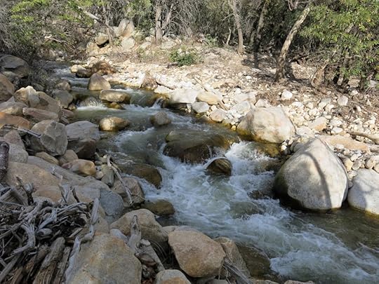
The Forest Service gates turned out to be open, but the old road was blocked by the creek that drained the canyon, in raging flood from winter’s heavy snowpack on the 10,700′ peak of the range. I would’ve needed a hardcore Jeep to ford it, so I parked, loaded up, and scrambled upstream looking for a place to cross. Someone had manhandled a log across a narrow spot, and I very carefully shimmied across, whitewater spraying my boots.
The trail I was aiming for was variously listed online as 5.3, 5.8, 6, 6.4, or 6.5 miles long, with an elevation gain ranging from 3,700′ to 5,700′. Were any of these numbers correct? From studying topo maps, I could see that the elevation gain from bottom to top had to be a little over 4,000′, midway between the conflicting online claims.
From the creek crossing, I walked up the old road and made a dramatic entrance to the canyon, with its roaring, boulder-choked creek and dense, canopied riparian forest of oaks and sycamores. The first thing I saw was the feathery, upraised tail of a whitetail buck, bouncing over a rise in the road ahead. After hiking a mile and a half up the rocky, sandy roadway, climbing several hundred feet in the process, I reached the trailhead, with a Forest Service sign showing the trail distance as either 6.5 or 7 miles, for an overall distance of 8 to 8-1/2 miles from where I parked.
I was getting an earlier start than usual – I’d left my vehicle at 9:30am and reached the trailhead at 10. Ideally I’d get back in time to drive to the nearest town, get an early dinner, and drive the two hours back to Silver City before dark. Knowing that dusk begins at about 7:30pm at home now, I figured I needed to be back at the vehicle by 4:30, giving me seven hours to hike. Probably not enough time to get all the way to the top – that would result in a 16-17 mile round trip, far beyond what I believed myself capable of – and no matter where I was on the trail, I’d need to stop and turn back at about 1pm.
But in my eagerness to hike farther and higher, I forgot about the time difference – I was now in a time zone that was one hour behind Silver City – and I conveniently overlooked the fact that I still had a 45-minute drive back to town for dinner. And lastly, unless the hike turned into a major bummer, I was likely to keep going 30 minutes to an hour beyond my planned turn-back point. That would only be human nature.
The trail twisted and turned its way up the foot of the ridge, between granite boulders, alternately appearing and disappearing. Sometimes I would find myself climbing through the dry, chest-high bunchgrass without any evidence of a trail, only to emerge on a ledge with a narrow path leading onward, looking more like a game or cattle trail than a hiking trail. But here and there were cairns, often only a single rock perched on a boulder. This had originally started in the 19th century as a pack trail leading to the peak from the fort at the bottom, where the prison is now. So it had seen a lot of use more than a century ago, by men riding horse or mule, but now seemed virtually abandoned.
Still, I was grateful for what trail I did find, because the vegetation on this slope was largely chaparral – dense thickets of shrub that would’ve been a nightmare to bushwhack around. I’d expected temps in the 50s, dropping as I climbed higher. But on this exposed slope it felt close to 70 degrees at mid-morning, and I was sweating profusely from the start of the climb. I’d started at 5,150′ elevation, and once I reached 7,000′, I hoped to find cool, shady pine forest and easier footing for the remainder of the climb.
Whereas many of the trails I’ve hiked have been damaged by erosion and deadfall in the aftermath of wildfire, this trail just seemed abandoned and overgrown. There was lots of evidence of trail work from the distant past – rock berms to divert runoff or mark the turn of a switchback – but they, as well as the trail itself, were often buried deep under thick grass or shrubs. Still, I’ve gotten pretty good at reading the ground, and I managed to stay on the path until the trail crested out on a high shoulder overlooking the main canyon. Here there was lots of evidence of isolated sparking from the last wildfire that had mainly burned the upper slopes, thousands of feet above.
And here I really lost the trail.
When you lose a trail, you need to stop focusing in front of your feet and look at the landscape holistically, as a tapestry that might hold barely visible clues. If there are shrubs or big trees around, where are the natural openings between them? Can you spot any disturbed or trampled vegetation, cairns or other man-made rock formations, patches of bare ground, saw-cut stumps or branches? Sometimes, off in the distance, you’ll sense just the barest hint of a path.
There on the shoulder of the ridge, there were lots of man-made rock piles scattered around. A hill loomed above, but the shoulder was fairly level and there were big junipers for shade, and a lot of cow shit. Some kind of ancient cowboy campground and recent bovine resting place.
I circled the area and set off in every direction that looked promising, but after a half hour of careful searching, I never found the trail. I could see some challenging terrain ahead, sheer cliffs, and whenever I tried to traverse around the hill to get to the upper ridge, I ran into a wall of boulders. So finally I just scrambled up the hill, and on top, in the least intuitive place, I found the trail again.
This trail is switchback-crazy. There are switchbacks with sections only a half dozen feet long, following natural fracture zones in the rock. Zigging and zagging, climbing and climbing through sparse oak and juniper forest, I finally reached some thin stands of short ponderosa pine, many of which had burned in the wildfire. It was now my planned turn-around time, so I stopped to have lunch. Another item I hadn’t factored into my schedule for the day.
But this was no kind of a destination. I hadn’t reached the cool, shady mixed-conifer forest that I’d expected at this elevation. There were cliffs towering above me, and I figured I still hadn’t hiked half the trail. I just couldn’t stop here. Chances are I wasn’t going to make it back home tonight, in any event.
So I continued, around and up the next level of the ridge, and around and up the next level after that. Here, after staying on the east side of the ridge for a long time, the trail crossed back over to the west side, where I lost it again. This time, it only took me ten minutes to relocate it.
It kept climbing for a short distance then began going gently down, for the first time on this hike, which was something I wasn’t excited about. I’d saved some simple topo maps on my iPad, and consulting them, I could see exactly where I was, at slightly less than 8,300′. Again, this was no kind of destination. The trail was getting ready for another major ascent of nearly a thousand feet, to the crest. But I’d climbed more than 3,000′ already, covering at least 6 miles one-way, and I really needed to turn back. I spent a few minutes stretching, in an attempt to ease my hip pain, then shouldered my pack and started down.
It was weird how elsewhere on this south side of the range, you would find dense forests of tall pines at this elevation. But on this outlying ridge, it was all open terrain, dominated by scattered oak and juniper, in what the Forest Service calls a “transition zone” amounting to more than 3,000′ in elevational thickness.
Down hiking isn’t necessarily easier than climbing. In this overgrown terrain, the dry grasses concealed loose rocks the size of tennis balls that twisted my ankle and made me stumble repeatedly, so that I really had to concentrate with every step. Apparently my new boots have really good support, because I made it without injury.
I lost the trail twice more on the way down, in different places this time, adding another 20 minutes to my hiking time. I was wearing shorts for the first time this season, and my skin had some kind of allergic reaction to the grasses on the trail, so my shins and the sides of my lower legs were quickly covered with an angry red rash. And I’d failed to apply sunscreen at the beginning, and now my calves were burned pretty badly. But when I reached the trailhead, and worked my way carefully down the old road of water-polished boulders, in the late-afternoon shade of the riparian canopy, I felt better than I had at the end of other, shorter hikes in the past months. It seemed I was actually making progress.
I got to town at sunset, found a cheap motel room, and discovered that since it was Sunday night, almost all the restaurants were closed. So I found myself ordering dinner and a margarita in a cavernous, obviously unpopular new place where only one other table was occupied. But I was really dehydrated – I hadn’t taken enough water on my hike and ran out hours ago – and I started feeling nauseous shortly after my food arrived, so I had to pack it up for the next day.
In my room that night, I checked the maps carefully to verify my distance and elevation. It’s clear from the topo maps that I climbed 3,150′, but considering how many times I lost the trail and had to scout far and wide to find it, and considering how many dozens of short switchbacks there were, distance is hard to estimate. I had to have covered at least 12 miles round trip in 7-1/2 hours of hiking – that’s the minimum, based on the Forest Service trail distance and the elevation profiles on hiking websites, and including the cut-off part of the old road that I had to walk back and forth to the trailhead. But I’m used to averaging a mile every 24 minutes, even with frequent stops, on our steep trails at home, which would yield almost 19 miles for the day. Highly unlikely, so I’m just calling it 12 miles and 3,150′.
Physically, in terms of my fitness and conditioning, it was a resounding success. I’ve been doing weekly cardio workouts for almost 30 years, but nothing like what I’m trying to maintain now. When I lived in the city, I did 4-mile runs, with little elevation gain, or mountain bike rides with at most a thousand feet of elevation. Now I’m climbing three peaks per week, walking fast, totaling up to 20 miles and 4,000′ of elevation gain. It seems crazy. I don’t want to overdo it, but I believe it’s good for me, and at my age, I need to work hard just to maintain my ability to do the things I want to do. And hiking is much more rewarding than the running or biking ever was, because it connects me better with nature.
But this abandoned, overgrown trail, with little variation from bottom to top, was a hike I won’t be doing again, anytime soon. Just too much work for too little reward!


