
A Tour of Ranger Island — CONTEST! UPDATED
Who wants to go with me to visit Fort Elizabeth/Fort Edward and Ranger Island? Grab your soft drinks and Doritos because today we're taking a MacKinnon's Rangers road trip!
OK, really we're just taking advantage of Google Earth. I wanted to share with you a bird's eye view of this part of New York that has become so special to me through the years — Fort Edward and Rogers Island. It occurs to me that this is kind of silly because I have actually on-the-ground images of all of these things taken from my trips to Fort Edward. But somehow it felt like I was taking you there with me when I discovered last night that I could actually look at Rogers Island via Google.
In the original published versions of Surrender and Untamed, I changed their names to Fort Elizabeth and Ranger Island. In the new author's cut of Surrender and Untamed — Surrender is out in five days!!! — I've changed Fort Elizabeth to Fort Edward but left Ranger Island because then everyone just wonders who Rogers is (a good thing to wonder, by the way). This made some folks in Fort Edward happy, because they live in one of the most important historic places in the United States — and no one has ever heard of them. And then a novelist writes a story about them, but calls them something else...
You can see how they might not like that so very much.
Without further ado, let's rev the engine and hit the highway.
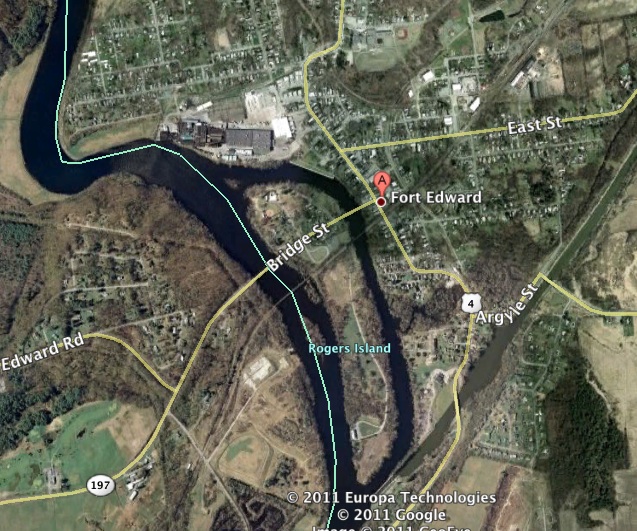
At top, you get a good overview of Ranger Island/Rogers Island. It sits in the middle of the Hudson River near the Great Carrying Place where Native people had to get out of their canoes and portage for a time. Fort Edward stood to the right of Rogers Island. The whole area is now the town of Fort Edward, but the fort itself stood not where the red dot is, but more where Highway 4 jogs to the right across from the island.
Think of the fort with a wide open plain in front of it used for drills. Beyond that on all sides is forest. Off to the left of the island and to the northeast stood a royal block house, completed in 1758 — I am winging the history, by the way, but I think that's right — which made this spot the most heavily fortified British military position in North America.
In other words, what you are looking at is arguably the most important spot for the British during the French and Indian War. (Fort Pitt, featured in Ride the Fire, and Fort Detroit were also important).
But let's move in closer and let the veil of history rise, giving us a peek back at the world of Iain, Morgan and Connor MacKinnon, and their adversary, Lord William Wentworth...

We come in from Albany, a port city that until recently belonged to the Dutch. We see mighty Fort Edward standing near that dark patch (center right) with the Union Flag flying from one of the fort's bastions. There, in the river we see a long, narrow island, Ranger Island, that bustles with activity.

Ranger Island is connected to the fort by a bateau bridge that stands about in the middle of the photo there. Made of small boats, or bateaux, that have been lashed together and covered with planks that are also lashed together, it gives the Rangers a way to get to the plain north of the fort to practice shooting at marks, which they do frequently.
In the winter, ice floes sometimes clog the Hudson, and the bridge would have been relatively easy to remove to prevent the floes from crushing it or damming the river and flooding the island (which happened often anyway).
Let's move in closer...
 Here you can see the actual site of the Rangers' encampment. The three white squares are excavated Ranger cabins that would have been used by enlisted men. They stood in rows, sharing walls with one another. The two larger white squares are covered excavations of officers' cabins. In one, a brass compass was found. I have a replica of that compass, which I purchased at the Rogers Island Visitor Center.
If you look to the upper left, you'll see a square marked out with a low wall of stone. That is a cemetery for fallen Rangers.
A moment of silence please...

Let's take a walk south, past fields where Rangers grew their food, great piles of wood used for cooking and heating, and pens and paddocks of animals used for food to a sad place, a place where there is much suffering — the smallpox hospital. It is believed to have stood near that pine tree in the center of the image.
Smallpox was still a deadly scourge in those days with very few people being inoculated against it, inoculation being something relatively new and deadly in and of itself at times.
Soldiers from the fort and Rangers found to have smallpox were placed in the smallpox hospital, isolated from the rest of the fort — except that their friends could come and visit. Not exactly quarantine by modern standards, which demonstrates a lack of understanding when it comes to infection control.
 Here's one last glimpse down at Ranger camp. The whipping post stood on the western edge of the island, toward your left, not far from the cabins. The small parade where the rangers mustered must have been near the cemetery. The officers' necessaries were on the eastern edge of the island, the enlisted men's on the right.
Think about this for a moment. Think 253 years ago when this would have been one of the most dangerous places on earth.
Now imagine rows of cabins, men busy repairing and caring for their gear, a great forest all around them. Tomorrow they leave on a mission. Major Iain MacKinnon is leading them northward to spy on Fort Carillon and see what Montcalm is doing. The men, all sons of Culloden or stubborn Irish, trust him. They've fought with him since '55 when Wentworth forced him to choose between being hanged or fighting for Britain.
They know from experience that anything could happen — ambuscade, sickness, injury, dangerous shifts in the weather. Some will not return alive.
On the way back, something unexpected will happen that will change Iain MacKinnon's life forever.

EXCITING UPDATE: Eileen Hannay of the Rogers Island Visitor Center posted a link on my Facebook page. I encourage everyone to read this. You'll get a quick overview of the real history of this site as well as some very exciting news pertaining to archaeological excavations on the island. Click here to read all about it, and come back and chat with me.
To see images from the ground, look for the In Search of MacKinnon's Rangers slide show on my blog down on the right-hand side.
Now for the contest:
Comment below on my blog and your name will be entered to win a signed copy of the new reissued version of Surrender, in stores on Tuesday. And if you care to share any Ranger lore, please feel free! I'll be giving away two books on Friday. (The author copies aren't actually here yet, but I'll save your addresses until they are. Not my fault!)


date newest »
 I'm so glad to hear that, Angela! Where did you get the advance copy of the book?
 Of course, I'm dying for you to finish it...
Pamela
 I review for Under The Covers Book Blog. Fran was able to get the ARC and distributes accordingly to the rest of the group for review.
 She is also dying to read it so, as soon as I'm done it's back to NY. This book went to NY to CA and back to NY again. Lol.
Ah! Cool! Nice to know. I never know how those things work. I'm so glad you're enjoying it. You can't be too far from the end...


I am loving Iain through and through.