
Quickstart guide: Cedar Mesa & Grand Gulch, Utah || Wild archaeological epicenter


Green Mask petroglyphs, Grand Gulch, Utah
Years ago I was turned on to Cedar Mesa by Alan Dixon, but needed inspiration this spring from the roamings of Paul Magnanti to plan a trip of my own there. It was a perfect couples trip for Amanda and me: the wilderness that I needed after a winter inside, with an additional and more unique dimension for her.
What is Cedar Mesa?
Cedar Mesa is an uninhabited 400-square-mile plateau in the southeastern corner of Utah, with elevations ranging from 4,500 to 7,000 vertical feet above sea level. Starting below Elk Ridge in the north, the cedar-covered mesa slopes southwards to the San Juan River, a major tributary of the Colorado; it is bordered by Combs Ridge to the east and Grand Gulch to the west.
The original boundaries of Bears Ears National Monument set by President Obama included Cedar Mesa, but the new boundaries established by President Trump do not.
What is Grand Gulch?
Most of the eastern half of Cedar Mesa is drained by Grand Gulch, a mostly dry meandering canyon that runs about 50 miles in length and that has a dozen named tributaries like Bullet, Shieks, Todie, and Cow Tank. It flows into the San Juan River, and is managed by the Bureau of Land Management (BLM) and National Park Service (NPS) as part of the Grand Gulch Wilderness Study Area.
Why should I go?
Cedar Mesa has many of the same appeals as other destinations in southern Utah: it’s a wilderness playground of deep canyons, lonesome plaeteaus, and endless slickrock.

Lower Bullet Canyon, typical southern Utah canyon country, with vertical walls and lots of slickrock
But Cedar Mesa — and Grand Gulch, in particular — has one additional appeal: thousands of Ancestral Puebloan cliff ruins and rock art.

Yellow House Ruins, upper Shieks Canyon
Overall, Cedar Mesa combines a wilderness experience on par with the Dirty Devil, Escalante, or Dark Canyon with an archaeological experience of a scaled-down Mesa Verde National Park. You will not find tourists, paved walking trails, restrictive backcountry regulations, and a glossy visitor center here.
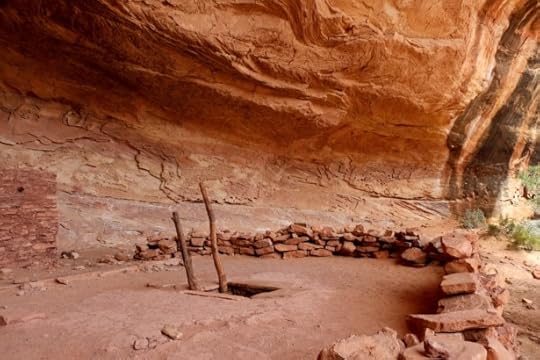
Perfect Kiva in Bullet Canyon. It has been restored and reinforced so that you can climb down into it.
How do I get there?
Cedar Mesa is in a figurative middle-of-nowhere. It’s:
2 hours from Moab,
3 hours from Durango,
4 hours from Flagstaff, and
5.5 hours from Salt Lake City.
It cannot be reached with public transit. A personal or rental vehicle is necessary.
What is the best time of year to go?
Cedar Mesa is a high desert. Winters are surprisingly blustery, and summers are insanely hot. Spring and fall are ideal.
Personally, I prefer the second half of April: new leaves and sprouts inject a lively color, and the days are pleasantly long.
Where can I stay and eat?
There are no commercial services on Cedar Mesa. Bring all the food and water you will need, and plan to car-camp or wilderness camp.
On your approach to or departure from the area, find limited services in the historically Mormon communities of Blanding and Bluff, as well as Mexican Hat. Expect small grocery stores, tired-looking motels, and short business hours.
We had a very good experience with Canyonlands Lodging at their facility south of Monticello. We also considered Stone Lizard Lodging in Blanding, but it was full.

The kitchenette in the very cute, very clean, and very comfortable Silver Cabin Room at Canyonlands Lodging
What should I bring?
A recommended gear list is beyond the scope of this quickstart guide. Consult my gears lists and The Ultimate Hiker’s Gear Guide for discussions of appropriate gear, supplies, and skills.
In general, be prepared for ample sunshine, brushy canyon bottoms, fine sand, and (usually) little water.
Is Cedar Mesa suitable for beginner backpackers?
I would not recommend Cedar Mesa for first-time or beginner backpackers, unless accompanied by someone with more experience. It’s an unforgiving place with few gimmes. The roads and trailheads are well marked, but otherwise there is no signage. The most popular canyons have unmaintained use trails with unreliable cairns. Water is scarce. Cell service is non-existent.

None of the use trails are maintained, and some are quite rugged. Shieks Canyon had several steep pitches up crumbly slopes of hardened mud.
What should I do while I’m there?
Cedar Mesa is appropriate for car-camping, day-hiking, and backpacking. I did not see promising terrain for or evidence of mountain biking or off-roading.
The San Juan is navigable, and a terrific (albeit ambitious) loop could be made by floating from Slickhorn Canyon to Grand Gulch.
The most popular canyons are those closest to the Kane Gulch Ranger Station and Highway 261. Loops can be formed by combining Grand Gulch proper with the side-canyons of Kane, Toadie, Coyote, Shieks, or Bullet. These loops do entail some overland travel that’s comparable to navigating the open ocean: there are few landmarks.
Do I need permits or to be aware of other important regulations?
A permit from the BLM is required to overnight camp in most Cedar Mesa canyons and to visit some day-use areas. More information. The permit can be reserved beforehand on Recreation.gov, and must be picked up from the Kane Gulch Ranger Station between 8 AM and noon.
Fires are not permitted in the canyons or on the mesa. Pack out toilet paper, because it does not degrade quickly in this environment. And do not foul the water sources.
Finally, and perhaps most importantly, please “take only photographs and leave only footprints” in Cedar Mesa. The ecosystem is very sensitive, and the ruins and rock art even more so.

Unnamed ruins in a deep alcove in Grand Gulch, between Bullet and Shieks Canyons
Where can I get more info?
The BLM has free maps and brochures.
For weather at Kane Gulch, use this point forecast from the National Weather Service.
AmericanSouthwest.net has good information about many of the canyons.
National Geographic Trails Illustrated offers a good overview map of the area, helpful for transportation and trip planning.
Use CalTopo to plan your route in greater detail and to print small-scale topographic maps, including USGS 7.5-minute tiles.
Peter Tassoni has written the sole guidebook for the area, A Hiking Guide To Cedar Mesa. It is the most comprehensive reference, and can supplement or be supplemented by online information.
Have questions about Cedar Mesa or Grand Gulch, or would you like to share your experience there? Leave a comment.
Disclosure. This website is supported mostly through affiliate marketing, whereby for referral traffic I receive a small commission from select vendors, at no cost to the reader. This post contains affiliate links. Thanks for your support.
The post Quickstart guide: Cedar Mesa & Grand Gulch, Utah || Wild archaeological epicenter appeared first on Andrew Skurka.


