Six lessons learned on my first high route || Wind River High Route, Loop 4

After taking Andrew’s Backpacking Fundamentals course in 2015, I decided to test my new skills on Loop 4 of the Wind River High Route. Prior to it, I had completed several trips on the Appalachian Trail and on the Florida Trail. The Wind River High Route promised adventure, but also freedom from fixed itineraries, designated campsites, and complex permitting schemes.
1. This is THE stuff, and off-trail is where it’s at
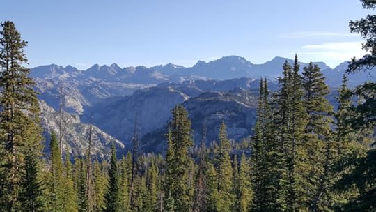
For this Easterner, even the on-trail portions of the Loop 4 section-hike were amazing. It was hard not to be smitten with the Wyoming backcountry immediately beyond Elkhart Park Trailhead. I moved quickly, only stopping at Photographers Point for a quick lunch and to dust off my map-and-compass skills by identifying peaks towering over Titcomb Basin, my intended exit path later in the week.

The view from Photographers Point
Many miles later on the outskirts of Bald Mountain Basin, my trip really started. I felt close to something I’d been looking for during all my time outdoors — a sense of freedom, adventure, and natural autonomy. I was heading into the wilderness alone, with no boundaries, no fences, and (mostly) no trails. When I left the Fremont Trail, I crossed a threshold for unmarked land with no fixed course. I was thrilled.
2. Trust the guide
Initially I was worried that Andrew’s detailed Wind River High Route Guide would take away some of the magic. I didn’t want to spoil the sense of adventure. But those worries were unfounded. One of my goals for this trip was to practice my route-finding and map-and-compass skills. Andrew’s maps included helpful notes but left plenty of opportunity to make my own decisions (and mistakes).
I bumped a pair of mule deer as I moved through Bald Mountain Basin, and then watched them bounce off into one of the many invisible folds of terrain that would later perplex me. With a full view of Angel Pass, I had plenty of time to consider the path ahead. Without a guide, it would never occur to me to try traveling over Angel Pass. Distance flattens the terrain, making steep slopes appear vertical. But Angel Pass hardly warrants even a mention in Andrew’s guide, so I took it on faith that it would go.
3. Map and compass is not route-finding
And go it did. This was my first significant route-finding challenge. In my mind, I had two main options. First, I could take a literal reading of the guide and walk down into the bottom of the basin and march straight up the pass. Or I could stay high and avoid elevation loss by following a slightly longer route north around the basin and hope to connect to a long, grassy bench beneath Angel Peak.
I learned fast that you can only see so much from one position. Without walking all over, you have to make a decision with limited information. Knowing how to read a map, find and transfer compass bearings, or operate a GPS doesn’t necessarily translate into effective route-finding. For that, more field experience seems necessary.

Angel Pass, the left low spot on the ridge, from Bald Mountain Basin. The guide recommended going to the base of the pass and grinding upwards. But from this vantage point it looked more promising to loop right/north to gain elevation and contour into the pass.
When evaluating an off-trail trip, you have to account for route-finding issues. Andrew provides a “Skurka Time” spreadsheet with his guide, but don’t let that fool you into thinking that hiking time is simply about fitness. It doesn’t matter if you can grind uphill as quickly as Andrew if you cannot find the optimal route up. I learned this lesson over and over. If this is your first off-trail experience, do not be optimistic with your schedule.

Wildflowers on a grassy slope below Angel Pass
4. This country is big, real big
Cresting the top of Angel Pass was one of the best experiences of my life. The sense of accomplishment was unforgettable, and the views were worth every step. Looking east beyond the Continental Divide and west across the front country I’d just crossed, I was engulfed in endless miles of mountain country.
But the excitement and wonder of my ascent slid into feelings of isolation and vulnerability. Frankly, it was intimidating, especially since the east side of Angel Pass appeared to be a heinous boulder field.
It took me hours to get down. Having to be that “on” for so many hours, knowing that with any step I could fall, sprain an ankle, turn a rock and be pinned there for hours or days, is something to be reckoned with. Descending took every bit of my focus, and it wasn’t until I bottomed out that I could begin to process and think about what lay ahead.

Extensive talus below Angel Pass, on its east side
The next few hours were classic high quality Wind River backcountry walking, and this helped me to refresh and recharge — just cycle in the ebb and flow of my mood on longer backcountry trips.
It was at this point when I realized that I did not bring enough sunscreen. A stupid mistake, a tiny little blemish in an otherwise extremely well-executed gear plan. But that wasn’t the only thing sowing doubt in my mind. Angel Pass wasn’t physically difficult or logistically challenging, but it did wear on me. And it readjusted my perception of the higher and more difficult passes to come. After hours of rock-hopping down Angel Pass, I was not ready to consider Alpine Lakes in my near future. By the time I made it down to camp at Golden Trout Lakes, I’d made up my mind that I was going to bail out.

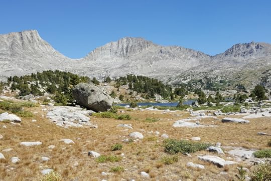
Above Golden Trout Lakes, after a long descent from Angel Pass
5. Be prepared to fail
It was tough to make a decision that felt like failure. But by that point, the nagging doubts in my mind were piling up: the extreme remoteness, the lack of sunscreen under a relentless sun, the nagging pain from a rolled ankle. When I picked this trip, I didn’t have a realistic idea of what tackling this high route would be like. But I did prepare for that eventuality, and changing my plans mid-trip was easy.
It was extremely satisfying to pull out my overview map and chart a course south down through a valley to which I had never been, never planned to go, and that was not my guide book. I marveled that at one point I had considered leaving the overview map at home.

I may have “failed” on the WRHR, but I still had the trip of my life.
6. Going alone is hard
Other than a couple camped at Golden Trout Lakes, I had the backcountry all to myself. Although I would have preferred to hike with a partner, there’s much to enjoy about hiking alone. Decision making is easy and efficient, for better or worse. You can go where and when you want, without concern for anyone else’s goals, physical ability, or safety.
Still, I think going alone was the key factor in not finishing the route as planned. Going alone meant being more conservative with my decision making, and it was easier for me to quit without someone there to psych me up for another pass. If completing a trip as planned is important to you, bring partners who share your abilities and goals. If you are forced to go alone, it can be done — but don’t underestimate the mental challenges you’ll face in addition to the physical ones.
I hope my story encourages some first-timers to get out there this summer and try something that really challenges them. If I can be of any help, feel free to drop me a line. david@sparkfire.net.
And a big thanks again to Andrew for putting together such a thoughtfully designed guide, and for generously taking the time to answer all of my questions prior to my trip.
The post Six lessons learned on my first high route || Wind River High Route, Loop 4 appeared first on Andrew Skurka.


