
Reader question: Should I change my High Sierra itinerary due the heavy snowfall?
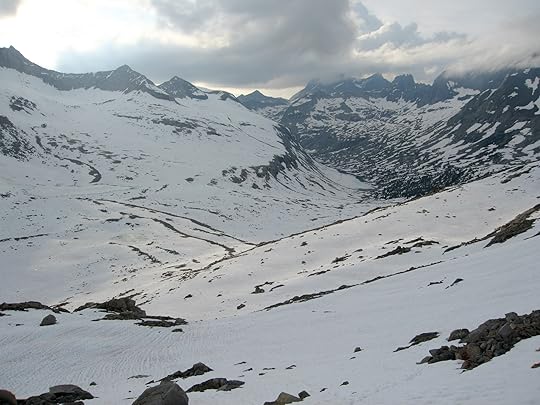

Extensive snow coverage on the north side of Mather Pass, looking towards Palisade Lakes, after a very wet winter. Taken June 28, 2006.
A reader question from Gabino:
In August I was planning to hike the Pacific Crest Trail through the High Sierra from South Lake Tahoe to Horseshoe Meadow. But all of this rain & snow has me concerned about lingering snowfields, high stream crossings, and late mosquitoes. Should I reschedule to September, instead?
I’m sure that every backpacker planning to undertake the PCT, JMT, Sierra High Route, Kings Canyon High Basin Route, or any other high-elevation route in California’s High Sierra is wondering the same thing right now. Here are some thoughts:
California’s snowpack: The Facts
There are many ways to record and analyze the snowpack, but I’ve always liked these snowpack plots from California’s Department of Water Resources. They show the current snowpack relative to the “average” winter, or to actual past winters.
If you have backpacked in the High Sierra for many years, this “percentage of average” figure can be used to accurately predict summertime conditions. CDWR divides the Sierra Nevada into three main watersheds. The High Sierra is encompassed mostly by Central and South.
In the charts below, you can see that more snow blankets the Sierra Nevada right now than anytime since the winter of 2011-12. Of course, several of these years were droughts, with the 2014-15 winter being the driest ever recorded.

This winter is tracking more closely to the biggest winters in recent memory — 2004-05, 2005-06, and 2010-11. And in the central and southern parts of the Sierra Nevada, it is on par with the wettest winter ever, 1982-83.

And the winter is not over yet
The snowpack typically peaks on April 1. In an average year, before April 1 more snow falls than melts; and, after April 1, more snow melts than falls. But wet winters tend to be longer, and the snowpack often does not peak until mid- or late-April.
Right now it’s only late-February and the snowpack is already well above its April 1 average. Even if the snow-machine turned off tomorrow, there is already so much snow on the ground that conditions will probably at least be “average” in the summer. More likely, however, snow will continue to fall and it will be a late spring.
Conditions after a wet winter
A wet winter presents a few obstacles for summertime backpacking.
Lingering snowpack
The High Sierra has a few glaciers and permanent snowfields. Everywhere else, the snowpack melts off completely. After a wet winter, it simply takes longer for the snow to melt.
Early-season hikers are affected most, with several miles of lingering snow on both the north and south sides of major passes. Look at the photo at the top of this page for a good example.
Sometime in June the snow becomes consolidated, and you can walk on top of it. But before that point, it rots in the afternoon (after the sun and warm temperatures melt the crust from the night before) and arduous post-holing ensues.
But even after it’s consolidated, the High Sierra snowpack is rarely pleasant. It becomes covered in small depressions (“sun cups”) that make for tedious walking.

Annoying sun cups near Selden Pass
High water and wet meadows
During peak runoff — normally in June, when temperatures are finally high enough to cause extensive melting — the rivers will be scary. At the right place and time of day, some will be pretty scary in July, too.
The creek flows are cyclical. In the morning, when temperatures are low and the sun is barely up, there is relatively little runoff. In the afternoon, after a full day of warm temperatures and intense sunshine, there is a lot. Plan your days around the creek crossings. And learn to read your map to identify safer ford locations — the trail is designed for July-September conditions, not June, and not July after a very wet winter.
By August the water levels should be manageable. When I did the JMT in 2010-11 after a big winter, there were only two crossings where we had to get our feet wet. Elsewhere, there were constructed bridges, downed trees, and rock steps.

In late-June 2006 I crossed Evolution Creek at the meadow about a half-mile above the trail crossing. Here, at 5 PM, it was MUCH safer. The trail crossing would have been a swim.
Mosquitoes
Normally the High Sierra mosquitoes peak in July, and dwindle or die-off in August as the meadows dry up. I would expect a late hatch, because they can’t come out until the ground is snow-free; and they will probably persist through August, until the first frosts of September.
Thankfully, mosquitoes can be managed. Some reading:
The Ultimate Hiker’s Gear Guide || Chapter 1: Clothing (newest info)
Core Clothing || Item #3: The Bug Shirt
Clothing system for peak mosquito season
Tips for Coping with Horrific Mosquitoes

Learn to manage mosquitoes, or your back will look like this. Donohue Pass, August 2011.
Should you change your itinerary?
Without knowing more about your situation, I can’t answer that for you. If you want some specific feedback, leave a comment below. Given the current conditions, I don’t expect any unprecedented challenges for 2017 hikers — we’ve seen these conditions before, although not often.
Some specific predictions:
May: Bring skis.
June: Anticipate extensive snow coverage at the higher elevations, and high water crossings, especially in the afternoons. Earlier in the month, the snow will often be rotten in the afternoon. Later in the month, most of it will have consolidated but it will be sun-cupped.
July: The snowpack will melt off and the creeks will come down, but the mosquitoes will hatch.
August: The first month of “normal” backpacking in the High Sierra, but with heavier bug pressure. It will be more like July.
Finally, September will be the nicest month of the year:
No lingering snow, high water, or mosquitoes;
Fewer people, especially after Labor Day; and,
Cooler daytime temperatures and a less intense sun.
Of course, September is always the nicest month, except when the High Sierra is on fire.
The post Reader question: Should I change my High Sierra itinerary due the heavy snowfall? appeared first on Andrew Skurka.


