
3D Printing Topographical Maps from Space Shuttle Data
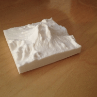 Here's how I wrote a program to convert the Space Shuttle Endeavor's geographical data into topographical 3D printed maps.
The post 3D Printing Topographical Maps from Space Shuttle Data appeared first on Make: DIY Projects and Ideas for Makers.


No comments have been added yet.
MAKE Magazine and Instructables.com's Blog

MAKE Magazine and Instructables.com isn't a Goodreads Author
(yet),
but they
do have a blog,
so here are some recent posts imported from
their feed.

