
Some Solo Exploration Beyond Mt. Atago
Note: this article may not appear properly in news readers.
This article contains interactive aspects that are likely removed by most news readers. Please see this particular article directly on Jeffrey's blog for full functionality.
Panasonic LX100 at an effective 24mm — 1/250 sec, f/5.6, ISO 200 —
map & image data — nearby photos
Different From Usual
Kyoto Arashiyama's Togetsukyo bridge from an uncommon vantage point
嵐山の渡月橋
After a wonderful ride with friends beyond Kyoto's Mt. Atago the other
day, I returned the next day for 110km (68mi) of solo exploration in the same general area.
Panasonic LX100 at an effective 75mm — 1/125 sec, f/5.6, ISO 200 —
map & image data — nearby photos
Bird and Bridge
more-traditional view of the Togetsukyo bridge
Early on in the ride I passed through Arashiyama in western Kyoto, with its famous bridge.
We've seen it before on my blog
in rain and in sun
and crowned by a rainbow. Today was fairly bland, but a big bird
was doing a batman pose, so that was something.
Panasonic LX100 at an effective 75mm — 1/125 sec, f/5, ISO 200 —
map & image data — nearby photos
“Me” Time
There's a path along the river southwest of the bridge that leads up to a temple with a great view that I visited some years ago, but apparently never posted about.
Anyway, the path is fine for a road bike for a while, and from the path I got the photo at the top of the page.
Eventually the path ends as far as bikes are concerned:
Panasonic LX100 at an effective 40mm — 1/125 sec, f/3.5, ISO 200 —
map & image data — nearby photos
End of the Path
unless you're really adventurous
It's probably not as bad as this climb, but I didn't have the guts
to try it just now.
Panasonic LX100 at an effective 24mm — 1/125 sec, f/3.5, ISO 200 —
map & image data — nearby photos
Near the End of the Path
Panasonic LX100 at an effective 24mm — 1/125 sec, f/1.7, ISO 2000 —
map & image data — nearby photos
Gathering Crowds
Arashiyama Bamboo Forest (嵐山竹やぶ)
The road through the bamboo forest in Arashiyama is a public road open to cars, but folks treat it like
their living room, wandering about aimlessly with their eyes glued to their camera or phone.
I then made my way up and over Mt. Atago, setting
a PR (personal record) by a wide margin,
which pleases me because I kept my effort low enough to not kill myself.
I missed beating my KOM time (“King of the Mountain”, the fastest time by a male) on
the Nishigaya Dam Descent by three
seconds because I saw a big monkey run across the road ahead of me, and didn't want to chance that there would be others. It's one thing to see wildlife at the side of the road
when slowly grinding uphill, but quite another when plunging downhill at 70kph (45mph).
Then for the first time I did the long fun New Momiji Descent, and
likely got the second-fastest time, but my activity doesn't match the segment for some reason. Sadly, the Strava support staff
member assigned to my query about it is either really lazy or a complete jerk because the cut-n-paste
responses have little to do with my actual question. It must be depressing to have a
job you just don't care about. Sigh.
Panasonic LX100 at an effective 72mm — 1/125 sec, f/5, ISO 200 —
map & image data — nearby photos
End of a Fun Descent
or start of a less-fun climb
Panasonic LX100 at an effective 24mm — 1/160 sec, f/5.6, ISO 200 —
map & image data — nearby photos
Flat Valley
Panasonic LX100 at an effective 24mm — 1/125 sec, f/4, ISO 200 —
map & image data — nearby photos
“Coffee” and “Open for Business”
sadly, neither were true
It was chilly (15℃/59℉) on the descent, so I was happy to find a coffee shop, but no one was around. I walked in and called out, but the place was deserted. Weird.
Panasonic LX100 at an effective 75mm — 1/160 sec, f/5.6, ISO 200 —
map & image data — nearby photos
Path Closed
Panasonic LX100 at an effective 24mm — 1/125 sec, f/1.7, ISO 250 —
map & image data — nearby photos
Mountainside Fountain
Much nicer than this, and sort of reminded me of
this. I paused to fill up.
Panasonic LX100 at an effective 75mm — 1/125 sec, f/5.6, ISO 200 —
map & image data — nearby photos
Mid-Climb Rest Area
Panasonic LX100 at an effective 24mm — 1/125 sec, f/5.6, ISO 200 —
map & image data — nearby photos
Nice View
Panasonic LX100 at an effective 24mm — 1/125 sec, f/3.2, ISO 200 —
map & image data — nearby photos
Intriguing!
unknown road rises sharply to the left
It wasn't unknown, actually, because I had done my homework.
It's a
short 180m at a steep 18%
access road to a water-storage tank...
Panasonic LX100 at an effective 26mm — 1/125 sec, f/5.6, ISO 200 —
map & image data — nearby photos
At The Top
Pre-ride research had brought me to this page that includes info
about this little climb. The photos at the time (three years ago) show little vegetation, but now it's
overgrown and encroaching on the road in a photogenically-pleasing manner....
Panasonic LX100 at an effective 24mm — 1/125 sec, f/4, ISO 200 —
map & image data — nearby photos
Heading Back Down
Panasonic LX100 at an effective 43mm — 1/125 sec, f/3.2, ISO 200 —
map & image data — nearby photos
Another Mystery Road
Panasonic LX100 at an effective 70mm — 1/125 sec, f/2.8, ISO 640 —
map & image data — nearby photos
Pretty Lane
quite steep, but it ends at a gate right after this
Panasonic LX100 at an effective 50mm — 1/125 sec, f/5, ISO 200 —
map & image data — nearby photos
Yagi is not Just a Town
it's an Amenity Town
( the only Japanese is the word for “sewer” )
Panasonic LX100 at an effective 27mm — 1/125 sec, f/5, ISO 200 —
map & image data — nearby photos
Amenity-Town Steepness
note that we're way above the house just beyond the car
Panasonic LX100 at an effective 43mm — 1/125 sec, f/4.5, ISO 200 —
map & image data — nearby photos
Amenity-Town View
Panasonic LX100 at an effective 24mm — 1/125 sec, f/2.5, ISO 200 —
map & image data — nearby photos
Amenity-Town Shrine
Hachimangu (八幡宮)
Panasonic LX100 at an effective 41mm — 1/125 sec, f/4, ISO 200 —
map & image data — nearby photos
Seen Better Days
according to the faded sign, a former drop-off point for a dry cleaner
Panasonic LX100 at an effective 24mm — 1/125 sec, f/2.8, ISO 200 —
map & image data — nearby photos
More Steepness
the photo doesn't capture it well, but
the road drops more than a story's height before the end of the building
Panasonic LX100 at an effective 60mm — 1/125 sec, f/2.8, ISO 320 —
map & image data — nearby photos
Thick
more “photo doesn't capture it well” with this one
the base is about 60cm (2') wide
I moved around to try minor roads I'd never been on.
Panasonic LX100 at an effective 24mm — 1/125 sec, f/2, ISO 200 —
map & image data — nearby photos
Pleasant Little-Used Road
Panasonic LX100 at an effective 24mm — 1/125 sec, f/2.5, ISO 200 —
map & image data — nearby photos
Secret Spot
Panasonic LX100 at an effective 32mm — 1/125 sec, f/2.2, ISO 250 —
map & image data — nearby photos
More Encroaching Grass
Panasonic LX100 at an effective 27mm — 1/125 sec, f/2.8, ISO 200 —
map & image data — nearby photos
Lovely Countryside Scene
with freshly-harvested rice on the other side of the river
Panasonic LX100 at an effective 75mm — 1/125 sec, f/2.8, ISO 1250 —
map & image data — nearby photos
Bridge of Dubious Reliability
Panasonic LX100 at an effective 24mm — 1/100 sec, f/1.7, ISO 200 —
map & image data — nearby photos
Another Side Climb
left for another time
I discovered a lot of new climbs and fun descents, and make some nice PRs (including one climbing
Kyomi North) without having
killed myself in the process, so that was very nice.
Less nice were the two flats I got at the end. I think the second flat was a tube that was bad to begin with, though it lasted
10 minutes, so I don't know.
All in all it was a great outing. As a bonus, for the first time this year, I was
actually ahead of my arbitrarily-picked 7,000km (4,350mi) goal for the year, which, after four months of unplanned travel,
I didn't think I'd be able to make.
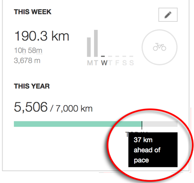
(I still might not make it, with less riding in the winter, but it looks promising.)
Here's the Relive.cc video of this ride...


Jeffrey E.F. Friedl's Blog

- Jeffrey E.F. Friedl's profile
- 13 followers

