Gaurav Punj's Blog
February 4, 2017
Leave the Chaddar alone
Then there is our world. Where we have made things easy for ourselves. Where we have built a shield between us and nature. Where we crave for that one act of bravery and adventure to establish our worth. And that one act has to be the highest, the wildest, the scariest, the best. What it can not be, is unknown. And we therefore turn our gaze, along with thousand others, to the Everest base camp, the villages of Spiti and the Chaddar trek over Zanskar.
Since 2011, when it was featured in a BBC documentary and subsequently termed as “the wildest trek in the world”, there has been a 100-fold increase in the number of people going for the Chaddar trek. Where just about 100 Zanskaris will walk over the river in the roughly two months its frozen, more than 7000 trekkers went for the trek in 2016, camping in overcrowded filthy sites along the river.
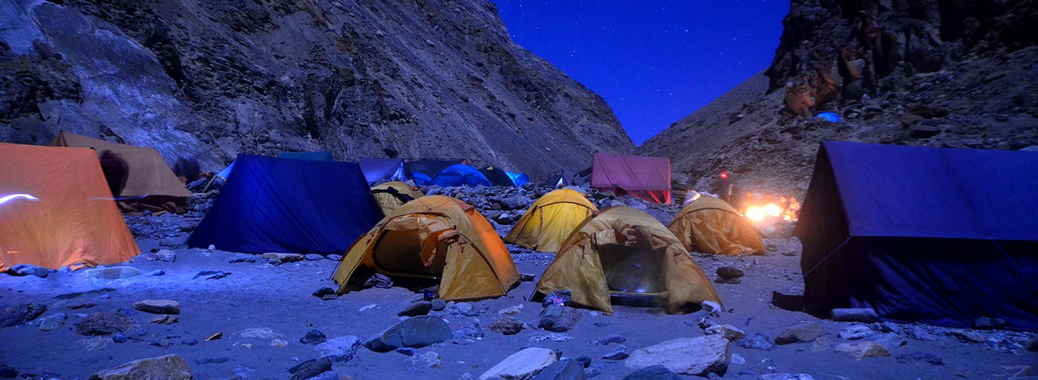 Pic source - Chadartrekladakh.in
1 river. 100+ trekkers a day. How much bio waste is generated daily? Where does it go? The sacred Zanskar. The river which is the lifeline of the locals. What about the heat generated? How much has it raised the average temp? Its effect on the river? If the river is not frozen, it means abandoning the trek for the visitors, but for locals it means taking the far riskier route along the sides of the steep gorge.
And then, the trekking ethics. Do the trekkers going for Chaddar understand the geography, the ecology, the culture of this place? Do they understand the ethos of trekking without leaving a trace? Have they trekked before in the Himalaya? Have they understood the gradual change in terrain, in weather, in the entire way of life as one moves from the lower hills to the meadows and streams of middle Himalaya and then to the passes across the Greater Himalaya connecting to the trans-Himalaya? Have they just flown over the whole expanse of Himalaya to land straight in Ladakh? And then followed behind a long line of other trekkers with their bags hauled by porters, utterly and completely dependent on them? Do they really believe this is the wildest trek in the world?
 Pic source - The Hindu businessline
The Chaddar trek has (unfortunately) become the marker of how much you don’t care for the ecology of the Himalaya, the ethics of trekking and the culture and rights of local people.
Himalaya has a lot to offer. Don’t be greedy. Spread out.


July 20, 2010
Altitude sickness
Concentration of Oxygen Remains the same regardless of Altitude. i.e 21%. So the amount of Oxygen in the air is the same always.
Dispersion of Oxygen molecules. Now, this is the important part. With height, the air pressure decreases and hence the Oxygen molecules (and others) are more spread out. What this means is the higher we go, the lesser number of Oxygen molecules inhaled per breath. At 3500M for example, there are 40% lesser Oxygen molecules per breath.
At what height? There is no agreement on this. Estimates range from 2500-3000 M. Lets stick to 2500M then.
Symptoms The most common and the first symptom is headache. The intensity varies. This is usually accompanied by nausea, breathlessness, dizziness, fatigue and an inability to sleep properly. Have any of these 3, and you can count yourself in. But check this out: statistically 75% of us get mild sickness above 3100M. Generally, (again there is nothing concrete here) these symptoms do not interfere with normal activity and subside within 48 hours. Symptoms do get worse at night (you are not breathing as hard).
What causes altitude sickness? Of course the lesser Oxygen our body and brain is getting. But how it exactly manifests is not clearly understood. As per a report by Princeton Univ, “It is considered to be a neurological problem caused by changes in the central nervous system.” (Whatever that means). So obviously the causes are more generic rather than specific:- Rate of ascent.- Individual susceptibility
Who gets it? Absolutely anyone. Regardless of age, sex, fitness levels and even those who didn’t get it the last time around. So you cannot not be careful.
Prevention.
(Or rather – Minimization of risk) Now, this is the important part. There are two approaches:1. Acclimatization.2. Preventive medicine. (I really am not a big fan of this. How do you prevent something you don’t understand the cause of?)
Acclimatization The only way out (I think). Also translates into – Gain height gradually. Give your body a chance to adjust and it usually does. I would add two more things however:- Hydration. (Add electral and it works wonders).- Food. DO NOT skip meals.
Going anywhere above 2500M, build in a period of acclimatization. (For example: Taking the Manali-Leh route exposes you to high altitude very quickly. The better way is the gradual ascent of the Srinagar- Leh route. Avoid flying into Leh as much as possible.)When trekking, your body gets a much better chance to acclimatize but still care needs to be taken. (And its easy to plan as height of most of the campsites will already be known in advance).
Preventive medicine Diamox is the accepted medicine as of now. In short, it allows you to breathe faster so that you metabolize more oxygen. As I said, really not sure about this. Especially the practice of taking it a week in advance, etc. Too many contradictory reports and opinions. I guess its best use is to help sleep in case of a mild altitude sickness. (Check for allergies to Sulpha though).
Acute mountain sickness (AMS) Whatever we discussed till now can also be described as very mild AMS. Anything more than mild AMS is life threatening. But trekkers can chill because rarely will you go to such heights so fast, its generally the realm of Mountaineers. Just know however, in case the condition of the person is not improving, there is a realistic chance of fluids seeping out of the capillaries and clogging the lungs or brain (no clarity on how and why this happens). The only way out is – Rapid descent.
My experience From the past 7 years of taking groups to high altitudes, this is what I have noticed:- Proper acclimatization (read gradual height gain), hydration and nutrition is the best prevention. Remember the 75% stat I mentioned from a research above. With these basic precautions, not more than 10% people in my groups have ever experienced altitude sickness.- Awareness is the key. An aware person deals with the discomforts of altitude sickness in a much better way. (They don’t panic, to start with).
Sources Internet of course. Princeton has a good research on AMS. The Himalayan club also has a decent booklet on altitude sickness. But mostly through experiences of fellow trekkers.
www.connectwithhimalaya.com
July 3, 2010
An oasis in the cold desert
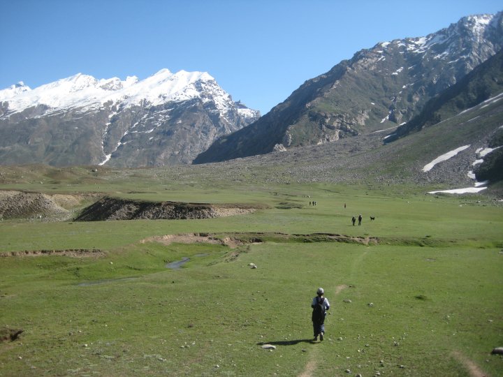
Ok, try to imagine this. You are walking on a flat grassland which stretches in all directions and is dotted with small yellow, white and blue flowers. Sheep are grazing merrily. Long way down your left, there is a sudden drop from the flat ground straight to a raging stream across which as abruptly rises a mountain with vertical rocky walls. Cut to the right side now and some way ahead there is moraine from the glacier spilling down a long chain of mountains with snow packed on their top. You meander along checking out the reflectionof the spotless blue sky and the mountains in a small glacial tarn. The day seem to go on forever and you have all the time in the world to chill on a flat stone nearby and watch the yaks watching you.
Now picture this. Its 8:30 p.m. You are camped on one of those meadows and are standing outside your tent. The near full moon has risen above the mountain chain on the right. There is so much light around that someone coming out of the tent can mistake it for dawn. The snow at the top is shining. Everything is still and the only sound is of the bells around the neck of the camp horses. The chill in the air is increasing but you want to savor this for as long as possible. Just staring away.
Is this what you imagination looked like?
And like this?

For more pics from our recent Miyar valley trek, check here
And a video shot at night, here
June 8, 2010
The land of Kauravas
“They” say that history is written by those who win the war. The Jaunsaris will agree. For this is the land where Duryodhan and karna have always been worshiped, where the natives are claimed descendants of Kauravas, where till date the local festivals celebrate defeat of the Pandava team in a game of ball against a Kaurava team. The temple architecture is rich, the traditions unique and the people very distinct. All ingredients worth preserving. But modern Hindu religion doesn’t seem to have a place for such differences. Not since Mahabharata beamed into every TV set and projected Kauravas as mean, deceitful, conniving savages against the brave, suffering Pandavas.
The proud, secluded Jaunsaris read the writing on the wall and en-mass decided to keep outsiders out of their way of life. Spend a week between them and you will probably not hear the word Duryodhana. They will worship him as they always had, but speak of him they wont. If they are not sure about your intentions they will even deny any link with Kauravas and say “what are you talking about”? And why should they not do this. They are social outcasts in Garhwal. No Govt. wants to be known as pro-Jaunsaris so they are practically living a century behind times. Villages as big as 250 families have not heard of electricity, school, road or medical facilities. No NGO’s operate here. No one speaks for them.
But there is hope. And thats in the form of sensible tourism. We trekked for 6 days in these valleys and they are amongst the best the Indian Himalaya has to offer. The meadows are huge and full of flowers, the peaks are all around and the camping sites abundant. Just about ideal for trekking. An umbrella group of local youth, trained as guides and porters, under ‘Har ki Dun protection and mountaineering agency’ organizes treks here and are starting homestays in the villages shortly. So what can you do? Just go see this place.
September 11, 2009
A Spiti story
In Spiti, the first son inherits the land, the second one becomes a monk and the third one is educated. A tradition dictated more by the economics of the land (limited cultivable land) than any other factor.
We were in Dorje's family homestay in Demul (a village in Spiti at 4300M). A concept started not too long ago by the 'snow leopard conservancy' in Ladakh and Spiti. The visitors, instead of pitching tents in the village farmland (which benefits nobody), enjoy the warm spitian hospitality and the host family gains financially. Probably the best of all sustainable tourism initiatives.
The child Lama had a calmness belying his age. "Do you miss home?" "Yes." "What do you do then?" "That evening I play really hard." Sorted, this guy was. He is staying at Komic monastery, at 4500M amongst the highest in the world and belonging to the Sakyapa sect of Tibetan Buddhism. What this means is that unlike the older sect (Nyingmapa) he will not lead a family life and will be a celibate monk for the rest of his life. He goes to the regular school in the morning and has his Buddhist teachings in the afternoon before he gets to his evening round of volleyball and running around. His regular schooling will end once he finishes 5th class and from then on its hardcore monastic life for him. And he is ready for that.
He was at home on a rare 7 day vacation. A time he spent with his entire family reaping the crop of Peas, the sweet tasting matars which the entire Spiti was harvesting at that moment. Their main source of livelihood, the once a year crop cycle ensures that, and food for the long long winters. (Along with Barley and Potato).
"Shouldn't we do something about Dorje being sent to the Monastery?" A lot of us asked this question or atleast thought about it. I guess what we need to understand is that this system has been going on for ages and is therefore something which has worked. A mixture of pragmatism and belief, its the way of life for them which of course we will not be able to comprehend.
Dorjey Phonchuk is a happy lama. He will be fine.
 Dorjey (right most one) with his siblings
June 10, 2009
Veil of the Goddess - Prelude
Nanda Devi is a shy goddess. From behind her misty veil she reveals herself only when she so ordains. The closer you get to her, less likely she is to give a ‘darshan’. But has that refrained anyone from toiling hard to reach as close to her as they possible can? Of course not. Such is her allure.
At 7816 Metres, Nanda Devi is the highest peak in India (with a catch- entirely in India. Kangchendzonga 8586M is shared with Nepal) and along with her sister peak Nanda Devi East (7434M) forms the most breathtaking, awe inspiring…. ok lets cut the adjectives… formations in the Indian Himalaya. Snow covered peaks (most of them above 6000M) formed in two concentric rings surround her. Viewed from the top it lies on the middle stroke of the inverted alphabet E, as the westerners will decipher it, or at the centre of an ‘OM’ formation, as romantics seeped in the spiritual significance of the Himalaya will see it. The bindu of the ‘OM’ being the Kailash mountain in Tibet. Just perfect.
[image error]
(Courtesy- Wikipedia)
The Devi, along with her two rings of mountains, is now part of what is possibly the last self-sustaining biosphere in the world. The Nanda Devi sanctuary. Protected of course from human intrusion. For reasons shrouded in controversy. But protected nonetheless.
Our specie can really be heartless sometimes. The unique flora and fauna of the outer and inner sanctuary must be wondering (at least those still surviving) what life for them would have been if they were left undiscovered. If the humans along with their pack animals and military scale expeditions had not ravaged the pristine wilderness. But they were mere spectators. Like the unsuspecting bharal (blue sheep) who instead of scampering up the slopes which they are so adept at, stared curiously at the gun barrels loaded to provide for the evening meal of the expedition members. Not so different from the unsuspecting Indian army who helped the CIA in a covert operation to place a nuclear device on top of the Devi, only to lose it and never recover it. (Or so they claim. Just google it.) The ticking time bomb or large scale environmental damage, whatever the reason, the authorities reluctantly had to close down the sanctuary in 1983. One can trek to the walls of the outer sanctuary but not beyond that.
Few regional rivalries can beat the one between Kumaon and Garhwal. Since recorded history they have fought, bickered, conspired against each other. But the only thing that unites them is Nanda Devi. Bang on the geographical divide, the peak holds sway over both the regions and rules as the dominant Goddess. The Garhwalis however stake their dominance as the 12 yearly Nanda Jat yatra passes through it. The Kumaonis, not to be left behind will tell anyone who will listen that the Nanda Devi east peak (it falls completely in Kumaon) is the real one on account of its truer dome shape.
Ok, so that was the prelude. Our trek story coming up soon….
October 4, 2008
Ladakh revisited
Sonmarg. Tourists go there to see, touch also, a glacier even in the middle of summer. For us it was the (forced) walk on the Sonmarg-Kargil road which made it memorable. Stream, wild horses, first glimpse of snow covered peaks. And the guys got a first hand experience of exactly how much a basket of cut-wood weighs (which the pahadi women carry daily for 5-6Kms). It will suffice to say that it took 3 of us to lift one.
Zoji la is a very historic pass. Through it caravans have passed for centuries as they crossed over the Greater Himalayan range and traded with central asia. From the green valleys of Kashmir one enters the brown starkness of Ladakh. Drass, with its now historic Tiger hill and associated 'points' is the first major town. Kargil soon follows. And then we enter the land of the world's last surviving Tibetian Buddhist society.
The future Buddha is the oldest. Ok, before you get too philosophical, I mean the rock-cut statue of Maitreya (future) Buddha at Mulbek is amongst the oldest testiment of Buddhism in India, dating to 1st AD. From there we are well and truly in Ladakh and soon reach Lamayuru, the oldest monastery in Ladakh. Btw, by now we have crossed over the Zanskar range also.
Leh. The meeting place of many routes of the silk trade. The main hub on the network. Historic. Now more of a shopping hub where a migrant population descends for 3 summer months, drive the locals out of the main market by paying higher rents and then proceed to fleece the tourists. It nevertheless is very charming. The warm sun, the blue sky, snow covered peaks on all sides, quite side roads of changspa, garden restaurants.... all combine to make it a very walkable place.
Siachen glacier. The highest battlefield. And to get there, the highest motorable road- over Khardung la. Ofcourse civilians can go only upto Panamic village in Nubra valley. Nubra valley is a fertile desert. Ok, sorry, its a fertile valley and has huge sand dunes also, where breed the only bactarian camel population of the Indian Himalaya. Two humped ones. Fun to watch, not ride.
Trekking. Why not walking, one may ask, as thats what it is actually. But then it wont have that glamour quotient. On our trek from Spituk we spotted many herds of bharal (called blue sheep, no one knows why) as they have descended to the valley coz of the coming winter. And the winter was coming fast. Much ahead of time. It snowed all day and night as we snuggled in our rustic homestay in Rumbak village. And the Stok la, our lakshya of the trip, 4900M high, was covered in 4 feet snow. We admired it from Rumbak and not so reluctantly walked back to Leh. Early winters, harsh summers, unseasonal rains.... the Himalayas are seeing it all. The battlefield of Global warming.
In an adjective laden trip, two more. The third highest pass took us to the 2nd highest salt water lake in the world. You know how some days are just perfect. It was one of them. Ah, the joy of frolicking in fresh snow on a crisp, bright, sunny morning. Even the tracks of bharal who scampered up the mountain as they saw our car approaching were well marked. Pangong Tso is shared by India and China, on paper. It is so beautiful...... well let me put it this way. We saw it, clicked pictures, felt its ice cold clear water, walked around its edges, dissipated to our quite corners and just sat for almost an hour by ourselves. Then we got up and drove back.
The snows we got in Rumbak were not just for Rumbak only. The entire range from Ladakh to Lahaul, Manali, Spiti, Simla, Uttarkashi received heavy snow and rains for 2-3 days at a stretch. The passes were blocked, the roads swept with landslides. The battle is raging. We waited for 2 days for the road to clear up, and so did most of the other tourists in Leh, but nothing happened. The airline companies, the ones who report crores of losses daily, saw in this a saviour and increased the prices three fold. Who can blame them. We had to fly. But as always the Himalayas gives back what it takes from you in some form. We flew over the entire breadth of the Himalaya on an exceptionally clear day (the pilot confirmed visibility of more than 100Km).
Juley!
August 16, 2008
The Kalpa Katu!!
Having survived the drive to Chitkul from Chandigarh (with a night halt at Sarahan) I got over-confident and decided to go on a short hike to Nagasthi, the last post of ITBP before China border. Point to be noted here: Rujuta chose not to come for this walk, which at that moment I thought as over-cautious only to realize later as another right decision by the most mountain savvy person I know. Chitkul is at a height of 3600M and that brings into play the vagaries of altitude sickness. And my mates on that trip got a live demo of 'The effects of Altitude sickness coupled with gastro on the human body', and mind I may add. Nausea- tick, severe headache- tick, loss of appetite- tick. The drive from Chitkul to Kalpa remains one of the most scenic rides for me, in words only. And did I tell you, it was my b'day that day.
Kalpa, in Sanskrit is a unit of time equalling 4.23 billion years (in Guiness records also). Kalpa, the erstwhile capital of Kinnaur, lies perched on the side of a huge mountain directly facing the magnificient Kinner kailash range, less than 10km as the crow flies. So close that you feel like running across the inbetween valley and touching the eternal snows. So close that even inside the guesthouse restaurant one has to wear sunglasses coz of the snow glare. The guesthouse btw is a wooden structure whose design has been copied, and copied well from the local architecture. This was also the place where the then GG, Lord Dalhousie sat and prepared the first draft of the Indian railways. Now, this is what I call a historic place. And here I had reached a state of desperation.
Well, in Mumbai I had just started taking an ayurvedic medicine 'Katujarishta' and it has worked quite well. We tried to get this almost every place we stopped on the trip but couldn't. Nothing else was working and in my mind I just needed Katu and I will be fine. Few Kms above Kalpa is Roghi, a small village with only two claims to fame -its the last village on the 'old' Hindustan-Tibet road on Indian side and it's 'suicide' point has a 100% success rate. To this village we went for a stroll. Amidst its ancient two storeyed houses and kids with Tibetan features there was a house with a red cross sign outside. On enquiring we found out it was a govt dispensary and the lady in charge was the most important person in the village. She was the chemist, teacher and the middle-woman of roghi. And she has in stock the 'Katujarishta'. For INR 1.oo only.
God resides in the mountains. I beleive it.
August 5, 2008
Stranded in the Pin Valley
As we walked up the stream towards Mudh village we could feel quite a few pair of eyes fixed on us. Couple of Indian trekkers in these areas accustomed to seeing Israelis and other globe trotters, generally does tend to raise eyebrows, but this was different. Conversations had stopped; a bunch of trekkers had stopped playing cards in the coffee shop to look out; children abandoned their football game and were talking excitedly. The remoteness of this village can not be the only reason.
Thoroughly drenched, we just wanted to get to a warm place though. Gatuk’s mother and sister were leading the way, while persistently offering to carry my backpack, and Nobjung was behind us. We entered from the ground floor and then climbed up a stair to the kitchen. The spitian kitchen, much like the ladakhi and infact the entire trans-Himalayan, is the centre of the house. The warmest, cleanest, most spacious and best equipped. This was a typical one. A large square room with the ‘chullah’ in the middle and a mud pipe rising from it to act as a chimney. One whole wall occupied by shelves with neatly arranged crockery and other utensils and an attached store room to keep all rations.
We sat on the seats made of thick blankets along two walls of the room. The chullah was continuously fed with fuel and was the source of all the warmth that was making us feel so much better. Warmth is precious for Spitians. Everything is designed to keep as much of it inside as possible. Mud walls, cattle on the ground floor and layers of hand woven blankets. This is what helps them survive the bitterly cold and long winters when the mercury drops to -25 degree C. Plus of course the ‘Arak’, alcohol brewed in house from Barley.
The view from the huge window in the kitchen was spectacular. The pastel shades of the mountains, the raging river, the rain, all combined to make it appear like a painting. We were offered some butter tea and then some more. Gatuk’s mother has been anxious about her son since last night as we were all supposed to reach here yesterday. She spotted the party from the window when they were not more than a speck.
We, along with gatuk the guide, kalu the cook, Lopzang the intern and 4 donkeys had started on the trek 4 days ago. Starting from the village of kafnu in Kinnaur, we had crossed over the Srikhand range via the Wang-khango pass and entered the Pin valley in Spiti. From the pine forest of kafnu, across the meadows of Phustriang, through the pastures of Kara and into the barren brown ness of Spiti we had walked. Oblivious of the unexpected, and until lately unheard of, rain which has been pouring down in Pin valley and other parts of Spiti, we enjoyed perfect weather and had climbed the 4865 m pass under a bright Sun.
Our first hurdle came in the way of the first of two streams one has to cross to reach Mudh. Usually a gentle stream, sometimes even a trickle, it had turned into a roaring torrent, blowing away the stone embankment which had never been tested before. After two hours of trying all means, only kalu amongst the three was able to cross it. He was sent to the village to get some help while we waited, still unaware of nature’s fury being enacted around us. In the last few days, flash floods had caused heavy landslides, swept away bridges and roads, stranded locals and tourists and even killed a few. When kalu didn’t return and threatening clouds started gathering over us we decided to pitch tent for the night.
It rained all night. Not heavy rain but persistent. We got up at 5 and with the help of gatuk and Lopzang managed to cross the stream, now flowing with slightly less vengeance. Took us almost an hour to do so and the effort drained us out. But we were finally on the other side and that felt good. Even the realization that two of our donkeys crossed and marched towards the village in the night, and we now have to share the load carried by them, didn’t dampen our spirits. Walking on the desolate trail in the bleak weather and amidst the gigantic scale of the Himalaya was an experience beyond words. The elements of nature conspiring to put things in their place. It was beautiful, scary, surreal.
As we approached Mudh we met kalu and a villager on their way to look for us. We were having serious concerns about the second stream and their sight was a relief. Kalu carried onwards to help his two friends while Nobjung accompanied us. The stream was wider and the water was very fast. But we had some experience by now and with the help of nobjung (who lent his back to my partner) we managed to cross it. The short but steep climb from there to Mudh was punishing.
Once everyone was seated comfortably in the kitchen kalu told us that the village and the entire Pin valley has been cut off from the main Spiti valley for almost 6 days. Many locals and some trekkers, including the group of Israelis, have been stranded. The nearest road head is 30kms away at Attargu, but bad weather and the risk involved has made them stay here rather than attempt walking. That was the only topic of discussion in the entire village. The weather patterns have been changing over the last few years they said. What was an exception is becoming more of a constant now. The high altitude desert is getting more and more rain every year. But the brittle terrain can’t take this and revolts ever so often. This time with much more fury. The ramifications of global warming, still a subject of academic debate and finger pointing, are very real here.
Rumours were getting wings. People were talking about how the mountain had collapsed or how the new bridge at guling was washed away within seconds. The best one was about a car that was apparently stranded between the villages of sagnam and tailing. Unable to go beyond either village, it has been ferrying passengers between these two villages. It had attained almost a mythical status.
After consulting with Kalu and Lopzang we decided to attempt walking to Attargu the next morning, provided the weather holds. We left early and reached our first stop, Tailing, in couple of hours. We stopped at Lopzang’s place for a brief while. Another round of the generous spitian hospitality and a change of clothes for Lopzang later, we were back on the road with Lopzang deciding to accompany us till Kaza. Just like that.
We were now in the land of the mythical Tata Sumo and my eyes were scanning the horizon for any sign of it. We had taken a short cut and hence were no longer on the road which was on the other side of the river. Crossed a bend and there it was. We all were shouting and pointing to the car, which was for real. It was on its way to tailing and by the time it comes back we would have anyways reached sagnam on foot. So we moved on, feeling lighter in our hearts and strangely very hopeful.
We had decided to cover the distance in two days and take a break at Guling, but we made good time and reached there by 2 p.m. The road until there was not bad with a few patches which have collapsed. The villagers told us that it’s a further 4 hour walk and the road gets quite bad. But some people have made their way across from Attargu this morning, so it can be negotiated. Well conditioned by now, have been walking for 5 days on that altitude, we were not tired. There was also a feeling of optimism amongst us and we decided to carry on.
As we moved along the road we came across landslide after landslide and gradually realized that the whole mountain side actually had collapsed on the road. We were now walking on the debris where the road used to be and the Pin river was flowing ever so menacingly close. Many a times we were on unstable land and could feel the ground move under our feet. No one was talking and we were moving silently in a single file. Even a small sound can cause landslides and the mountain was still very dangerous with small stones coming down ever so often. At one place there was a huge hole in the middle of the road and a raging stream of water coming from the hill was swirling and going straight in. We had to walk across it and could feel water gushing under our feet. It was truly nerve racking.
There were small parties of locals coming across from the other side, all walking purposefully. We kept asking how further to go and always got, ‘just a bit more’ as the answer. It seemed unending and we walked over 5 kms on the debris before we finally saw a lone bulldozer fighting its way across. He had been working since morning and has cleared a patch of only 100 meters or so. The worst seemed to be over and we rushed onwards. Finally around 6:30, after walking for 30kms and for 12 hours, we reached Attargu. Luckily we soon got a car which took us to Kaza and then to Demul, our next destination.
Pin valley is one of the remotest places in the Indian Himalaya. It is one of the most awe inspiring also. Its a place for realizations, positivism and gaining perspective on life. Its tantric sect of Buddhism with its wandering lamas, the Buzhen, enacting the teachings as they travel gives it uniqueness in the unique Spiti valley. This amazing culture has survived for centuries under a harsh terrain and climate. The simple and very hard working people here are at a loss to understand the changing patterns of the weather. They sometimes hold themselves responsible for making their god/mountain angry. We know they are wrong. Don’t we?
July 29, 2008
Go toh Go!!
Kashmir or rather the Kashmiris at this point of time are in a strange state of mind. The golden past and the current turmoil of course contributing to this. A predominantly tourism based economy, Kashmir has always been the pioneer in providing ‘services’ to the visitors. The world was in love with the valleys of Kashmir and even before Yash Chopra shot there foreign tourists were arriving in throngs. And not the least coz of the enterprising Kashmiri who has built lodges and houseboats, learnt the art of organizing treks for Sahibs and pretty much cracked the puzzle of ‘fine’ hospitality. But the fine balance between being cordial and being overbearing is not that easy to maintain I guess and soon Kashmir was notorious for its in-your-face souvenir sellers on the dal, put-up arrogance (which gradually became second nature) of the local businessmen and the openly discriminatory (atleast give them that) attitude towards Indian tourists (as compared to foreigners. Tips in dollars…. before the Israelis arrived on the scene). Its not correct to generalize but that was the impression one brought back from a must-go trip to Kashmir.
So, a completely tourism dependent economy + arrogance which has become second nature + tourism at what it is now = confused state of mind. Kashmiris not only have to deal with the volatile political situation in their state and with the rapid growth of Himalayan tourism in other states (at their expense they believe) but also have to reconsider their way of dealing with visitors. And yes, the accent has to go. Most, most definitely.
And then there are the gujjars. And the bakrawals. And the chaupans. Herders of cattle, goats and sheep respectively. An entirely unique set of people. They have been leading the same way of life for ages now, they don’t recognize state borders and most intriguingly they don’t give a damn about anybody. Very similar in their looks, traditions and attitude. But make the mistake of mistaking one for another and they will not waste a moment in correcting you, sternly of course. They live a semi-nomadic life with separate winter and summer homes. The summer abode more a temporary shelter of rock and wood high up on the mountain than a home actually. But cozy nonetheless.
It was in one such shelter that we stumbled to on our trek to the ever receding kolahoi glacier. A two day walk from Aru near Pahalgam, the trek is through the beautiful Lidder valley and follows the river to its source at the glacier. Pahalgam is probably the most affluent of the famous townships of Kashmir with its economy boosted by the annual Amarnath pilgrimage. The season was on and the chaos visible in Pahalgam. But Aru, being in the opposite direction of the yatra route has retained its quiet and charm and considering that it can be reached in 6 hours from Mumbai is highly recommended.
As we approached the final moraine of the glacier the heat, the wind and the altitude were taking a toll and the endless boulder hopping was getting to us. Finally our guide pointed to a stone hut and uttered the magic word: “Maggie”. We literally gate crashed into the hut, which was a chaupan settlement by the way. The lady of the hut was inside on the chullah along with a neighbor friend and their children. The hug she gave Rujuta was, to say the least, special and I would leave it to her to describe it. After the customary round of pictures of the hut and its inhabitants, who more than happily posed for and infact even demanded to be clicked, we settled down with our plates of Maggie, cups of lipton (chai as we know it) and kawa (chai as they know it). The sheer energy in the laughter of the women was mesmerizing. The younger one had a child in her lap who was sliding down towards the floor as she chatted and laughed with us. Suddenly as Rujuta realized his slide she pointed to him with a start and a oh-no expression. The woman’s response has by now become legendary (amongst those present there from our group) and has sparked many debates and revelations. And yes, for most of us it has also put quite a few things in perspective. She continued laughing, casually pulled the child up and said, “Go toh go!”
P.b: Kashmir is very picturesque. It is quite safe also. The locals want peace because that gives them their best chance of survival. Tourists. There is an understandable sense of desperation amongst everyone involved in travel industry at the moment but I am sure they will get their act together soon and the enterprising Kashmiri spirit will come forth.