
Sheila Peters's Blog, page 6
August 26, 2017
McCabe Trail
[image error]Three routes from Driftwood Road give access to Harvey Mountain: Lyons Creek, Harvey Mountain and the McCabe trails.
I first set foot on the McCabe trail in 1977 or 1978, can’t quite remember which. Joe L’Orsa took a group of us (including Walt Taylor, Mike Morrell and his son Tomas) up the Lyons Creek trail to the lake just above its headwaters where some of us swam. We then dropped down on what is now called the Blix trail until a tiny path emerged out of a wet meadow full of flowers. Mike and his son went right to follow the McCabe trail to its summit above the Little Joe lakes; the rest of us turned left to follow the trail down to Sunny Point.
This was not yet a park and there were no signs signaling trail heads or route distances. But we had Joe who grew up travelling in these mountains with his family. At the hike’s beginning, he stopped just below the Lyons Creek trail entrance to show us where the trail originally began. It used to be called the Gale & Lifton trail and was, he wrote in his unpublished A History of the Babine Mountains Recreation Area, “already considered an old trail by 1921. It may have followed an ancient Indian entry route, possibly into the marmot ground near Ganokwa Basin.”
We passed the old sawmill site, the remnants of which are still visible, and struggled up the hill to the long central stretch where the climb abates for a few kilometres. The trail was often muddy and not always clear. Joe was very patient as we struggled towards treeline. Hiking was still new to me and I suffered from the delusion that if you sweated and struggled up steep inclines swatting mosquitoes, you weren’t having fun.
[image error]Once in the alpine, we followed the trail around to its junction with the route leading over Padella Pass and turned left to follow the creek up to the lake we call Number Six Lake (if you look down from Harvey Mountain you can see a six or a nine clearly drawn by the lighter sediments on the lake bottom). The shintangle almost obliterated the trail up the creek, and the route down was equally sketchy. It was hard at the time to believe Joe’s stories of taking horses down there. It’s still hard.
[image error]Once on the McCabe trail, we had a pleasant walk out though I don’t remember much of that specific trip. When I think about how many times we’ve walked it since, the years blur together. We often take visitors up to a lookout point where you can see across into Silverking and catch a glimpse of the cabin there. The dramatic drop is stunning and we almost always see goats.
[image error]According to Joe’s research, the trail was built in 1919:
The famous McCabe trail was constructed, from the wagon road below Sunny Point, along the backside of Harvey Mountain, to the Copper Lakes area. This trail was built – or caused to be built – by Red McCabe, on a trail grant under the provision of the Mines Development Act.
Red McCabe didn’t get his name from the colour of his hair: he was the president of the local chapter of the old Socialist Party of Canada and prospected with two other party members – Pat McPhee and Jim Carson.
McPhee had been prospecting in the area for at least fifteen years by then. Joe describes a trip taken in 1905:
Provincial Mineralogist W. F. Robertson makes a major trip from Quesnel to Hazelton. From a camp at the Hudson Bay Ranch in Driftwood, he visits the Babine Range, with Pat McPhee as a guide. Apparently they went up what is now the Lyons Creek Trail and visited the … claims on what is now known as Harvey Mountain.
[image error]Jim Carson had a camp just above the bridged creek that crosses the trail below its opening into the boggy meadows where the Blix trail takes off. Joe showed us the remnants of his camp as we walked out. The only evidence now is a wire scar left in a big spruce tree where he pitched his tent. (Carson Basin, a long gentle slope on the north flank of Pyramid Mountain, is also named for him. If you poke around up there, you’ll find lots of old adits.) I’ve been told Axel Elmsted, another longtime Babine Mountains prospector, used to call the mountain Bolshevik Hill because of the three men’s political affiliations.
[image error]After crossing several brushy slide areas, the trail further down traverses a big rock slide that pre-dates its original construction. If you stand on it and look down, you’ll see just below another path crosses the rock – this is the trail that leads down to the spot on Driftwood Creek where the engineers who surveyed the trail (hence it’s pleasant grade) camped. More on that another day.
Tony L’Orsa, Joe’s older brother, still remembers when the McCabe trail was wide enough to be the wagon road instead of the narrow path it is today. There used to be a cabin not far from Sunny Point which was burned down by the forest service, he said. Later exploration tore up the original trail’s beginnings, but it remains one of the most scenic routes into the Babines and, on its lower reaches, provides splendid views across the upper Driftwood watershed.


July 10, 2017
A Review of the Driftwood Canyon Fossil Beds
Sheila and Lynn are celebrating having lived beside the Driftwood Canyon fossil beds for more than forty years and I have been asked to present a little of our current understanding of some of the stories that the fossils tell us. A few million years ago, the spot where they are living would have been beside or in a lake, rather than beside a creek.
The Driftwood Canyon fossil beds are a remarkable natural library. The pages of this library are thin layers of sediments that were deposited annually and upon which were imprinted the records of a few of the happenings at that place and time. That place was a freshwater lake and the time was about 51.77 million years ago, during the Eocene Epoch on the geological time scale. The age was obtained from uranium-lead dating of the mineral zircon found in a layer of volcanic ash. The exceptionally well preserved fossils here offer us a few glimpses into a little-known part of Earth’s history.
Figure 1: Pages of history in the Driftwood fossil beds. The rocks shown above represent thin layers of mud, fine-grained silt, and local bands of volcanic ash that settled on the ancient lake bottom now exposed at Driftwood Canyon.
Image by A. L’Orsa.
The formation of the ancient lake now exposed by Driftwood Canyon approximately coincided with the onset of basaltic volcanic activity in this area about 51 million years ago. In this general area, there is some evidence that basaltic flows locally blocked river valleys and formed lakes. Basaltic mountains, such as China Nose Mountain near Houston, are remnants of some of these volcanic events and have their own stories to tell. Driftwood represents the most northern of dozens of fossil-bearing lake and swamp exposures of similar age that have been discovered southeasterly from here, through the Cariboo (Horsefly), Kamloops (McAbee), Falkland, Princeton and down to Republic, Washington. This discontinuous and time-restricted accumulation of fresh-water sediments, with many fossils in common, represents fragments of a relatively warm upland ecosystem, now collectively referred to by researchers as the “Okanagan Highlands” (including Driftwood). In addition, there are extensive lake deposits of similar age in Colorado, Utah and Wyoming, which also contain many superb fossils.
The early Eocene was an interesting time in Earth’s history. Earth was experiencing one of its several “greenhouse” climatic events. The climate was much warmer and wetter, and there was probably no permanent ice at the poles. Atmospheric carbon dioxide levels are estimated to have been much higher than they are today. Average temperatures were apparently a little warmer than in southern coastal British Columbia at present. Fossils of palms and members of the walnut family indicate an even warmer climate at lower elevations. Many of the trees listed below also grew in the High Arctic at this time, where exceptionally well-preserved fossil forests have been discovered, as well as fossils of alligators, turtles and many mammals. The “greenhouse” conditions peaked about 50 million years ago and then the temperature started to decline. By the end of the Eocene Epoch, Earth was rapidly cooling down to the “icehouse” conditions that we consider “normal” today.
Plant fossils that have been reported from Driftwood Canyon include alder, birch, cypress, elm, false larch (Pseudolarix), ferns (especially the floating fern, Azolla), fir, ginkgo, hemlock, oak, pines (note Pinus driftwoodensis), redwoods (Metasequoia and Sequoia), sassafras and spruce. Some of these tree groups still grow in the area, but many others now only grow naturally in warmer and moister climates in Asia (e.g. dawn redwood, false larch and ginkgo) or farther south in North America (e.g. oaks and redwoods).
Two examples of fossil tree leaves from Driftwood Canyon are pictured below, followed by pictures of their nearest living relatives. These pictures help to remind us that these fossils, although they may now appear rather dull, were once live, green and vibrant plants living in a lush lakeside forest.
Dawn Redwood (Metasequoia sp.).
Photo by Ken Pugh.
Dawn redwoods were common in western North America in the Eocene, but gradually became extinct, or so it was thought. In the mid-1940s, a Chinese forester found a few “living fossil” dawn redwoods in a forest in southwestern China, apparently on the verge of extinction. Seeds and seedlings were collected and now these trees can be seen in gardens and parks around the world, including in southern British Columbia.
The only known surviving dawn redwood species (Metasequoia glyptostroboides).
Image: Public Domain.
Ginkgos are another easily identified, but rarely found, fossil at Driftwood Canyon. They represent a “living fossil” that can be traced back more than 200 million years. Ginkgos are locally common in the sandstones of the Skeena Group that probably directly underlie the Driftwood Canyon fossil beds and outcrop in places downstream along Driftwood Creek. Although these trees had an almost worldwide distribution some 200 million years ago, for many years they too were thought to have been extinct in the wild, but they had been preserved in temple gardens and other cultivated places in the Orient. Recently they too have been found growing wild in a few Chinese forests. Extracts from the leaves have long been used in Chinese medicine.
One half of the leaf below can be seen at the Bulkley Valley Museum in Smithers. The other part is in a private collection.
[image error]
Ginkgo adiantoides. Identified by Glenn Rouse, UBC. Scale in millimetres.
Image by A. L’Orsa.
[image error]
The last known surviving ginkgo species (Ginkgo biloba). This young tree is growing in Halifax.
Image by Judi L’Orsa.
The scientist who has been at the center of plant fossil research at Driftwood Canyon in recent years is David Greenwood, a specialist in plant fossils at Brandon University. He is the leader of the Okanagan Highlands Project. For more information on his work, click here for his website.
Insects reported from Driftwood Canyon include lacewings (note Pseudochrysopa harveyi, named in honour of Gordon Harvey by Bruce Archibald), March flies, crane flies, snakeflies, mosquitos, water striders, bees, wasps, gnats, earwigs, ants and termites. Some of these species are only found in warmer climates today. Bruce Archibald, Simon Fraser University, has recently been studying the insects from Driftwood Canyon and other Eocene sites. His website is here.
[image error]
March fly Plecia (?) from Driftwood, private collection.
Photo by Ken Pugh.
Fish fossils found at Driftwood Canyon include the important “dawn salmon” Eosalmo driftwoodensis first described by Mark Wilson, who teaches at the University of Alberta. It is the oldest known fossil member of the salmon family. The dawn salmon has since been identified at a few other Eocene sites in British Columbia and at Republic, Washington. Other fish fossils found at Driftwood Canyon include suckers (Amyzon) and members of the bowfin, mooneye and trout-perch families.
Mark Wilson has not only worked on the fishes at Driftwood and other Eocene and older fossil localities, he has studied Eocene insects and he has studied the environments of deposition in Eocene lakes. To visit Mark Wilson’s website, click here.
[image error]
Eosalmo driftwoodensis. Identified by Mark Wilson, University of Alberta.
Bulkley Valley Museum collection.
Image by A. L’Orsa.
Bird fossils are very rarely found, but an important discovery was made in 1968 by Patricia Pedley who split a piece of shale and found a fossil bird of the “rollers” family (Coraciidae; Primobucco). These birds have been found at other Eocene localities, especially in the Green River shales of Colorado, Utah and Wyoming. They are extinct in the Americas, but members of this family still exist in warmer parts of the Old World. Most of the living species are in Africa.
Fragmentary fossils of a member of the hedgehog family and a tapir have recently been described by Jaelyn Eberle and others, and represent the only mammal fossils reported from Driftwood Canyon to date. Click here for a review of the article.
Driftwood Canyon Provincial Park was established in January 1967, after pioneer Driftwood farmer, Gordon Harvey, donated 14 ha of his farm to the British Columbia Government, which added 9 ha of Crown Land, to cover the key outcrops of Eocene fossils exposed by Driftwood Creek. This is a Class A park and removing fossils from the park without a permit is contrary to the Park Act. However, it was Gordon Harvey’s wish and understanding that fossil collecting by the public would continue, and there were no serious attempts to enforce the rules until recently. We have to follow the rules, but there may be a way to permit public collecting provided that important fossils are recognized and preserved for study. A good solution to this problem has been developed in Republic, Washington, at the Stonerose Interpretive Center (http://stonerosefossil.org/fossilhunting/visitors-information/) where limited supervised collecting is allowed and school children are encouraged.
Fossil discoveries at Driftwood and other places continue to make important contributions to our understanding of the development of life on Earth. Now, with the Earth possibly on track for a change back to a greenhouse climate, fossils can help us understand probable responses of plant and animal communities to that projected change. There is more work to be done and a few rocks are eroding off the cliffs every year, providing easy access to new samples. However, with very limited budgets and other interesting fossil sites calling for their attention, institution-based scientists can only do so much here. Fossils left weathering on the ground are not contributing to science. Supervised fossil collecting by hobbyists and students might not only inspire potential new scientists, but might well bring us the next important discovery.
Books of Interest
Ludvigsen, Rolf, editor, 1996. Life in stone: a natural history of British Columbia’s fossils: UBC Press, 310 pages.
Tidwell, William D., 1998. Common fossil plants of western North America, 2nd edition: Smithsonian Institution Press, 299 pages.
*Tony is the elder son of Fortunat and Harriet L’Orsa who moved to Smithers in 1935. Both he and his younger brother, Joe, were born in Smithers. Tony is a geologist and has long had a special interest in the fossil beds found at Driftwood Canyon Provincial Park. Thanks for this wonderful article, Tony.


July 3, 2017
What’s blooming in Driftwood Canyon?
[image error]When we swat away the mosquitoes to climb into the summer alpine, we take a good look at what’s quite literally under our noses (easy to do as you climb because you’re moving slowly and your nose is often close to the ground), the micro-view matches the expansive mountain vistas. Patches of moss campion, inkypot gentians, tiny potentilla, anemones, the mosses, the blooming heather, meltwater tumbling down through picturesque grottos streaked orange with xanthoria to form pools of astonishing clarity, well, why would anyone bother planting tulips or petunias? And this is early in the season, before the avalanche slopes and lower meadows are knee-deep in valerian, hellebore, artemesia, lupines, and I know I’m forgetting many others.
Even at lower elevations, where we do plant tulips and petunias, the flora is sumptuous – Lynn valiantly mows the grass to keep back the press of fireweed, cow’s parsnip, young aspens, and roses that form a wall of vegetation – this time of year filled with the squawks, screeches and chirps of fledglings, soon to be gone either up high, further into the bush or maybe even back south. Our trail up out of the canyon needs regular attention to keep back the thimbleberry, snowberry, roses and young maple shrubs joining forces with the nettles, meadow rue, chocolate lilies, false Solomon’s-seal, columbine, twisted stalk, star-flowered Solomon’s-seal that all spring up new every single year. An astonishing fecundity.
I wrote a series of sonnets that were gathered in a chapbook Leaf Press published last spring- it has an impossible name – The Bathymetry of Lax Kwaxl – and arose from a kayak trip we made to the Melville-Dundas group of islands off the northwest coast a few years ago – Lax Kwaxl is the Tsimshian name for the islands. This is the first sonnet in the collection.
My curtains close against the winter darkness
scuttling through stripped down trees and shrivelled asters.
Summer is filed in photographs, in salmon
fillets and halibut buried in the deep freeze.
We struggle to remember willows frothing
with wind, with leaves and yellow warblers. The garden
green with cabbages and garlic scapes unfurling.
Grizzlies fat with sockeye, salal and huckleberries,
first children of a succulent world. Our kayaks
hang in the shed above a rolled up pea fence
and empty flower pots. The battered hulls tell stories
of rasping barnacles and the rumble of bull kelp
under the keel. Outside, the tide of snow
eats up the last light of fallen leaves.
It all happens so fast. And is over so soon. On a walk up the road, I stopped to take stock, to see what flora is here, right now, in Driftwood Canyon:
cow parsnip just beginning
more roses than we’ve ever seen before, but they’re fading fast
sitka burnet
arnica
geraniums – sticky and cranesbill
cut-leaf anemone or Anemone multifida
columbine
paintbrush
Jacobs ladder (almost done)
clover
large-leafed avens
a few fireweed swelling
bedstraw – its red roots a good dye
the nasty hawkweed – such a lovely yellow
buttercups
daisies
peavine and vetch
alfalfa
the bear berries (twin berries) dangle black from their red bracts – the birds (and bears, I guess) love them
Saskatoon berries are forming
raspberries in flower
currants and gooseberries
wild strawberries ripening – hot and sweet
soapberries beginning
snowberries still hiding, waiting until September to surprise us
Leaf miner has returned – the wonderful aspen green is turning silver yet again. And the cottonwood seeds are floating through the air like a lazy snowfall, blowing in the open door, snagging on pots, in the woodshed, reminding the grass that winter is not far off. But for the moment, oh, the wonder of it!


June 26, 2017
Driftwood Creek – the wellspring of our lives
Riding my bike down Driftwood Road. Riding into a tunnel of sensation, the gravel rattling my tires, flickers erupting from the ditches, the creek a muffled roar on my left. Sweet with the smell and sight of the big white plumes of flowering false Solomon’s-seal. And the roses! There has never been such a year for roses. I ride into a wind, heavy with roses. Past a thicket of elderberry bushes, a copse of cottonwoods, across the bridge. Leaving the creek and climbing out of the canyon into the expanse of (I think) an alluvial fan formed when the glaciers receded into the remnant snowfields of the Babines leaving an outwash of the gravel underlying the fields beside the Driftwood school and Glenwood Hall at the Telkwa Highroad.
[image error]I turn to ride down the highroad to Glentanna—a ribbon through a pastoral landscape—and the rising wind carries new smells. First horses as I pass Eileen Shorter’s farm, the L’Orsas’, then cows in the Nageli’s fields and more horses up around the corner past the Northern Wildlife Shelter. The Bruhjells’—cattle ranchers from the early days—and then hay, the cutting just beginning, the air thick with its fragrance. Down through the pungent odor of dairy farms—Ewalds’, Brandsmas’—as I make the turn, not up Snake Road past Veenstras’ toward Sturzeneggers’, but left and down once again towards the creek. It is only then the wind lets up and I coast down to the driveway that leads to Tristan and Damien Jones’ place on the edge of the steep drop that gives Snake Road its name.
They bought the land from the Sturzeneggers in August 2001, started building the next spring and moved into their new home in November, 2002.
[image error]
Brent Patriquin photo
Tristan tells the story:
“We came here to visit my aunt and uncle (Peter White). We came in November and it was pouring rain. The next morning the clouds parted and there was snow on the peaks. He started driving us around the valley; I looked at Damian and said, I could live here.”
The house they built shows some of the influences of Tristan’s Banff connections—she grew up in what she calls the Whyte bubble—the Whytes are an old Banff family deeply connected to the park’s mountain culture. She and Damian ran a guest lodge in Canmore and both wanted out of the hospitality business, into a life that offered Damian more opportunities for creativity.
[image error]“It took us four years to sell our place—Uncle Pete was our land agent. The month we closed the sale of our guest lodge, this place came up for sale.”
Tristan figures they passed some kind of test because they were grilled closely about their plans for the place before the Sturzeneggers agreed to sell. Peter and Paul, the brothers, spent a lot of time on the property fishing both on the river and the creek, and were pretty attached to it.
As well as wanting to snowshoe and hike on their property, Tristan and Damian hoped to get right off the grid. Leroy Taylor (who owns land on the other side of Driftwood Creek as well as 40 acres below their place down to the confluence) talked them out of early plans to build a micro-power project on the creek because it tends to wash out significant sections every few years. Instead they’ve installed solar panels, built a root cellar, greenhouse and planted a big garden. Along with Damian’s parents who live right next door, they are about 80 per cent there in terms of self-sufficiency, Tristan says.
And they’ve made room in their busy lives for creativity: Damian’s Harvest Designs creates beautiful furniture out of re-purposed wood, he builds guitars for Rayco Resophonics and plays guitar with The Train Wrecks.
Tristan loves the solitude as well as the convenience of being just 16 km from town.
“We live on a bear highway. There’s an ephemeral creek and when it dries up the bears have to go down to Driftwood Creek to get water and we see them coming through. My brother was sleeping in our cabin and spent an hour one morning watching a bear eating Saskatoons outside the window. We see them eating dandelions, tearing up anthills. One day we watched a mom introduce her cubs to an anthill—they’d jump in and then jump back—it was hilarious.”
[image error]And the hiking is amazing. “Last summer I hiked every Friday and all summer we saw four other hikers—the people from Banff and Canmore don’t believe us when we tell them.”
Everywhere I walk with Tristan today, we see the iconic view of Hudson Bay Mountain and we hear Driftwood Creek.
“I love that I can hike up to the headwaters of the creek that runs past our home, that waters our garden —it’s the wellspring of our lives here.”


June 20, 2017
Father’s Day Flood, 1986
Poem published in Confluence, May, 1997.
They’re cutting hay in the Driftwood watershed. Great thick swathes of hay, rolling out behind the mowers. Not like last year when early heat and almost no rain burned the fields into spindly stalks. It’s been cool this spring, and moist, with just enough heat to warm the soil. And the midsummer light, the lushness of it! As we tilt toward the solstice, the sky keeps opening up. Our old cat stays outside all night, prowling in the barn, playing tag with the pine marten.
Driftwood Creek is, however, is already past its solstice. A couple of weeks ago we had heavy rain and the creek came up into its final muddy freshet. The snow is almost gone up high and on this Father’s Day, the creek was subsiding into its blue-green summer colours.
Things were different in 1986. Lynn had just come home from an emergency medical trip to Vancouver, a trip that turned his thoughts again to nursing. We were glad to have him home to celebrate Father’s Day, but it had been raining for three days straight. Hard, hard rain, pelting down. Coastal rain. And there was a lot of snow in the mountains that year.
We lay in bed, listening to boulders rumbling down the creek. It was an unnerving sound. Our house is a few hundred metres from the creek; our bedroom was on the other side of the house. The phone rang. It was our neighbour down the road, Sonja Lester, who lived just below the bridge that connected us to the outside world. Don’t try to drive to town, she said. The bridge is in our yard.
[image error]
The first bridge on Driftwood Road is ripped out by the high waters of 1986. Sonya Lester says they figured the beaver dams just up the road blew out in a tidal wave of water and debris which picked up the bridge and carried it down to their yard.
[image error]
Lesters’ house – the creek is on the left, the road is to the right, out of the picture.
We scrambled out of bed and high-tailed it over to the parking lot at the fossil beds where a car had spent the night. The bridge to the fossil beds was gone too and we had to shout to be heard. We told them to stay put. The bridge is at a bend in the road. You wouldn’t see that it was gone until you were damn near on it. They’d been camping further up, they said, but the rain and rising water sent them downstream. They’d been worried about the bridges above the Kings’ house, many of them makeshift contraptions. They thought they’d be fine here.
[image error]
Juniper Ridington, (l) Antonia Mills, Michael (l) and Daniel Shervill at the bottom of our driveway where the current bridge crosses to the fossil beds.
We checked with our neighbours up the road. Antonia Mills, whose cabin perched on concrete posts, had seen her winter tires washed away as water ran right under the house. A bit further up Park Road, two families were cut off by the rising water. The Seychuks watched the creek cut a path to within a few metres of their house. A helicopter came to evacuate the Hamelinks. Further up, a section of road was cut away and the bridge just above Wayne and Gida Kings’ – then the last house on the road – washed out. It was several years before it was replaced, before hiking into the Babines from the Driftwood approach didn’t involve nerve-wracking crossings on slippery logs.
[image error]
Herb Buchholz describes waking to find water rushing through the dip between their cabin and the driveway out. As well as the rest of his family, he had two little ones to care for – his 2- or 3-year-old granddaughter, Tasha, and a baby coyote one of his boys had rescued from the railway tracks. He strung a rope across the dip so they could safely cross – at one spot it was running pretty fast, he said. He was pleased when his old Ford pickup, half submerged in the water, started up first try and they were able to drive it out. Here his sons Karl (l) and Lyle make the crossing.
Sonja Lester writes:
I woke in the morning to the sound of rolling rocks and when I looked out the window we had water flowing everywhere around the house and a bridge parked just upstream. Throughout the day the water built up behind a dam of debris, which included large cottonwood trees, just above the house with the fear that it too would let loose and swipe the house out with it.
We had two neighbours with Cats show up who attempted to remove debris. One in the creek….with the other chained to it to anchor it. When they left that night they took the keys of the Cat with them so that Richard [Sonya’s husband] wouldn’t get in there without a support system.
The kids went off the property in a helicopter and I went out on the blade of a Cat. They had a command hospitality system set up at the community hall.
She added three notes from her children:
Larry had helped me rototill the day before and said, “Gee, Mom I really wanted to work in the garden today.” (He had been helping a friend sandbag at Telkwa with no clue that we were in flood).
Rich looking out the window at the brown, brown water said, “Mom, we don’t have to move to get a change of scenery do we?”
And Jenny standing on the bridge by Eileen Shorter’s watching equipment work to take out debris and talking to Al Fletcher asked, “Mr. Fletcher did you see my house go by yet?”
George and Diane Loset live up Gilbert Road, on the other side of the bridge Jenny was talking about. The debris washing down the creek was battering the bridge’s pilings, George said, and they were trying to catch it to protect the structure. The bridge was eventually replaced as was the bridge just above our place.
Sonja describes two dreams she had:
One of just exactly what would happen – brown, brown water flowing around my house. In the second dream I was looking at my house with a man standing shoulder-to-shoulder with me and my house was on stilts. He said, “Would you look, your house will be fine.” They had to convince me to leave that day because I knew my house would be fine.
The newspaper referred to the bridge above Lesters as the Foss bridge. Fred Foss owned the property straddling Driftwood Road at its intersection with the Telkwa-Moricetown Highroad. He donated the land for the first Driftwood School, the current structure and Glentanna Hall.
Our boys were supposed to begin swimming lessons that week … luckily for the folks at this end of the road, the Mounseys had put in a precipitous driveway up and over the canyon wall (to access the house that is now Stefan Schug’s residence), so those with suitable vehicles were able to get in and out.
[image error]
CN track dangles above the washed out rail bed at Moricetown. (Photo courtesy Interior News)
Further afield, the CN track at Moricetown washed out, the Bulkley at Telkwa was ripping right through Eddy Park where the adjoining Overstall home was getting major sandbagging detail.
In several places, Driftwood Creek carved an entirely new course. The sauna Rick and Karen Careless built in the early 80s found itself stranded on the other side of the creek, inaccessible. Parts of the road into Silverking became creekbed; in places the old creekbed was reconstituted as road. It wasn’t the first time this had happened – old water courses can be traced all up and down the creek, some still running as ephemeral creeks in spring.
We were all astounded at the creek’s ferocity – feeling the kind of pleasurable excitement that comes with lots of drama and no immediate danger. The creek has approached that level a couple of times in the intervening thirty years, but matched that year. Huge angular boulders, rip rap, were dumped along the stream banks in Driftwood Canyon Provincial Park and along vulnerable housing sites. But the bailey bridges brought in to replace the washouts and the others weakened by the ferocity of the water and the debris it carried are still with us.
[image error]
Daniel Shervill supervises the installation of a new bridge, the one that’s still in place.


June 12, 2017
Into Silverking
After reading Mel and Evi’s memories of Gisela and Silverking, we set off on Sunday to see just how far we could get into the basin before the snow defeated us. Last year this time, remnant snow appeared just after the Danny Moore confluence and we were only able to get as far as the cabin because a handy troupe of high school students had snowshoed in a few days earlier and a hard frost the night before solidified their track very nicely for us.
This past Sunday, we once again had a nasty frost down in the canyon; luckily I responded to the cold and clear sky just before I went to bed and covered the marigolds and zucchini. Ice furred the perennials and froze any standing water. Most plants survived, though I’m sure they’re all just a little shocked. But I checked back in our weather diaries – about 20 years worth – and June frosts appear regularly. As do days with highs of 30.
[image error]
Elderberry bursting into leaf.
We had easy walking most of the way. Saw a harlequin pair just below Danny Moore creek, rays of light illuminating the male’s colours. A spruce grouse in a sub-alpine fir – red eyebrows flashing in the gloom. The greenery exploding; yellow violets, some budding lupines.
[image error]
If you look closely, you can see the harlequin pair.
Then, just below the basin, snow. And postholing. It’s like walking a tightrope strung about three feet above the ground … stepping lightly, balancing, holding your breath, arms out until wham, you break through, thigh deep in snow. Haul your leg out and recommence the breath, the light steps until you’re down again. You look ahead at your companions who stagger like drunks, lurching and cursing.[image error]
But it was well worth it, eating lunch on the deck of the Joe L’Orsa cabin, sun shining, no mosquitoes. I notice in our weather diaries this time of year, all the notes about bugs or the blessed lack of them. We were lucky.
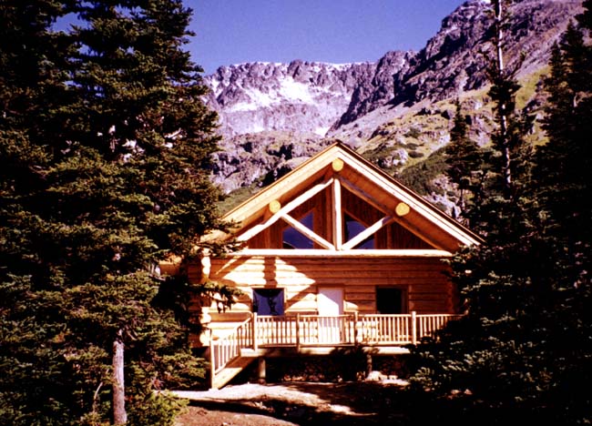
The cabin is beautiful – a log structure that is much more than a cabin. Built by local log house builders, Wes Giesbrecht and Dennis Clark, I well remember the day they helicoptered the huge logs from Wes and Dennis’ building site right over our house into the basin. More on that another day.
[image error]There are three log books in the cabin now – all telling stories of visits to the basin, summer, fall, winter and spring. School trips, visitors from around the world, people re-visiting their youth, remembering loved ones, out for adventure. The ones who come year after year. Notations about birds, plants, snow depth, avalanche risk, the state of the cabin, animal sightings.
Just as we walk the same stretch of road day after day, year after year, noting both returns and losses, seeing how the freshet changes the curve of the creek, tumbles old trails into the water, we walk year after year into Silverking Basin. Remembering when the big flood took out the bridges. When the road was re-routed and new creekbeds carved. Grateful to still be able to make the journey.
[image error]
Lynn inside Joe L’Orsa cabin.


June 1, 2017
Gisela Mendel – June in Silverking Basin
Well, June is here and the creek is into its third and biggest freshet so far this year. Its roar fills the canyon and carries a freshet of cold air down from Silverking Basin. June is also the time of year when the phone calls from intrepid hiker Gisela Mendel would begin: the fairy slippers are in bloom, the clematis have appeared, the trail is open. And I’d (mostly) happily drop whatever chores I’d assigned myself to head outside with her.
I was by no means the only recipient of these calls. Mel and Evi Coulson sent me this contribution to the Driftwood Creek annals – the photos are from 20 years ago when the bunkhouse in the basin was still standing. The photos are theirs. Gisela died in April 2008.
[image error]
Gisela in the bunkhouse – 1996. Eileen Astin has done a painting based on this and will enter it in the Canada 150 exhibit at the Smithers Art Gallery.
Hi Sheila,
Those early season camping and birding trips into Silverking Basin were initiated by Gisela. She was afflicted more than most with cabin fever and couldn’t wait to get up into the mountains at the first opportunity. She wouldn’t go on her own, but would prevail on victims to go with her, and that generally meant us. We have her diary for 1995 to 1997 (given to us by Rika) and she writes for 24th – 25th June, 1996: Silverking Basin with Evi & Mel Coulson (almost by force!)
This was long before the Joe L’Orsa cabin was built, of course. We slept in the old mine cabin, which had one room reasonably well fixed up, including a wood stove donated by RSF Energy. The problem was the porcupines. You could hardy sleep at night because of the sound of them chewing at the plywood underneath the cabin. One year a porky actually got into the cabin and, being the male in the party, I had to escort it out. I managed to shoo it down the central corridor, but unfortunately the door at the end was closed. So, with the porky trapped at the end and using an aluminum shovel to protect my shins (I was still in my pajamas) I managed to reach over the cowering animal to open the door where it obligingly left. However, 2 hours later it was back underneath chewing away.
[image error]
Gisela and Mel outside the bunkhouse in 1996. The old foreman’s cabin is to the right – the headwaters of Driftwood Creek up behind.
Most times there was still snow in the basin at this time of year, but with Gisela in command we always had full days. We would hike up to Silverking Lake or to Hyland Pass and glissade down the snow banks. Birds were already active, with the Fox Sparrows, Wilson’s Warblers, Varied Thrushes and Golden-crowned Sparrows in full song. It was actually the 1996 trip when I recorded birds for my bird song CD, including the Fox Sparrow and Blackpoll Warbler. The latter is not very common and when we first saw it we thought it was a chickadee. Only when it sang did we realize otherwise. I always tried to record the Dipper, which has a lovely (and loud) song, but it sings infrequently and I never managed to get it.
I should also mention Gisela’s unique way of wading creeks. At that time there was no bridge over the creek at the entrance to the basin (the one draining Silverking Lake) and it was usually in spate with the spring runoff. She would carry 2 heavy duty plastic garbage bags and pull them over her boots and tie them up around her thighs. She would then wade the creek as quickly as possible so that if the bags tore there was little time for water to enter. If a bag was damaged, she would simply replace it. This was much quicker than taking off boots and socks, which is what we did.
She was a remarkable lady, in fact one of the most remarkable people I have met in my life. Her diary is very interesting. Mostly it just lists the hikes she did (about 3 a week), who went with her and the flowers she saw etc, but occasionally she pens something quite eloquent, such as this entry:
Microwave trip – July 7th, 1995. We went down soon to escape the rain and I walked enchantedly through these upper blooming alpine meadows: early & late flowers all out, a magic carpet of delights. The older I get – now 73 – the more I enjoy the privilege of seeing those flowers. The more I realize how limited these physical endeavors to the alpine will be for me the more I delight in these wonders.


May 21, 2017
Time is never wasted
[image error]So there’s all this river of life stuff of course, all the creek metaphors I’ve flogged over the years, but who can help it, the creek being the way it is? Freezing, thawing, flooding, the torrents and quiet pools on its way to the river, to the ocean. The ducks, the dippers, the pea boat races.
A little forked root I’ve tossed pops into an eddy and circles the same ten inches a dozen times. Around and around and around. A tiny snag of current almost catches it. Drops it. Back it comes. Again and again and it’s hard to not to throw the pebble that would send it on its way.
If you happen to think of that root as a metaphor – idle, stuck, aimless, adrift, wasting time – well, the sun was at just the right angle to light up all the dark branches holding out the new green leaves in the way that happens only in spring. The Pacific wren flooded the bush with its whole kit and caboodle. The creek, well, it rushed and warbled and pooled and waterfalled and cooled the heat and chased away the flies. And, my god, there were sticky cottonwood buds littering the air with the smell of fresh beeswax in a spring-sprung hive, that smell of the nurseries that give us the self-same honey we drip onto still warm bread. The little root spends time this afternoon like time is nothing to get hung up about. That same old time is setting aspens all a tremble, giving them a little twirl, each cluster in its turn.
So who’s to say what’s a wasting? So what if we forget for just a moment to think about what comes next? Who cares if the skin falls slack from our arms as we bend to take a drink beside the old dog, to lap the water together? Yes, when we think to look again, the root is gone. Who cares? We’re still squatting, quenched beside the creek.


May 15, 2017
Gordon Harvey – tenacity and transience
When we first arrived in Driftwood Canyon, Gordon Harvey had just died (December 1976) but his house, a shed, a bathhouse and a log barn were still standing.
Stories about Katherine, Peavine and their son Gordon Harvey are layered into Driftwood history. Peavine had a claim on Harvey Mountain (named after him) and any hikers going up the Harvey Mountain Road trail passes by the remnants of his cabin at one of the switchbacks. Gordon, in his memoir below, speaks of his father’s booming voice and real estate savvy. Wet’suwet’en stories speak of how he used that voice to intimidate them during the years when they were being steadily evicted from their homesites along the Bulkley Road (now the Telkwa-Moricetown Highroad).
[image error]Katherine played piano at many parties and was known to be pretty feisty. Some say the way she heated her house burned down three of them – if you’ve ever tried to saw logs into woodstove-sized lengths with a swede saw, you’ll understand her preference for opening the door to the woodbox, shoving in one end of a log, leaving the door open and just pushing it further in as it burned.
After his parents’ death, Gordon continued to live on the family property, another one of the valley’s eccentric bachelors. He told his family’s story in Bulkley Valley Stories, published in 1973.
Memories of Driftwood Canyon
My father, C.G. Harvey, arrive in Hazelton in 1907 where he entered the hotel business. He was one of the “Big Three” with “Black Jack” McDonell and Jack Sealy. He was also engaged in the land promotion business. Happy Turner wrote: “he was a good one to spy out the land and in no time, was on speaking terms with every section post in the district. He is still pushing in a tunnel on Harvey Mountain with a true prospector’s optimism.” He located, for Jack Sealy, a large ranch in the Driftwood Creek area, which is now the even larger Bill Morris ranch. [This has since been split into several properties.]
Prior to coming to the Valley, he prospected in the Kootenays, California, Mexico and the Yukon.
My mother was born in London in 1882. In 1908, she came to Canada, working in the law office of R. B. Bennett who was M.P. for Calgary West and later Prime Minister of Canada. On she moved to Vancouver and then north to Prince Rupert and up the Skeena by river boat to Hazelton. There she worked in the office of District Mining Recorder, S.H. Hoskins, father of the retired Ford dealer, Os Hoskins.
In 1912, she and my father were married and carried on the hotel operation until 1914. Then that summer they rode horseback to Smithers with me, their six month old son, strapped to the saddle. When we reached the Sealy Ranch, the young foreman, Bill Kirton, recently arrived from England, took us by wagon over a rough mining road to our property on Harvey Mountain – on the way to Silver King basin. Sometime later dad broke his leg at the mine and we found him in the cabin administering his own first aid. He had taken apart a section of stovepipe and was using it as a cast. We pulled him out on a hand sleigh to receive medical help.
My mother and dad carried on mining operations under the most primitive conditions with hand drill, shovel and wheelbarrow. I worked in our mine when I was eleven. They stuck with what he described as the only “mine in the Babines” – others were only prospects.
How did my father get the name “Peavine Harvey”?
On one occasion, he was preparing exhibits of Bulkley Valley produce for the PNE at Vancouver. Included was a sheaf of our famous timothy hay and some wild huckleberries.
The night before he left, some “friends” stole into his hotel room and made some changes. In place of timothy, they put in a bundle of local peavine hay and replaced the berries with a box of rabbit manure. He didn’t discover it until he arrived at the PNE in Vancouver.
“Peavine” Harvey will be remembered for his booming voice – he was hard of hearing! A stenographer who worked for the Government Agent, Mr. Bryant, said the whole building vibrated when Peavine greeted the staff in the office. My mother, a bit of a woman about five feet tall, was an accomplished musician. She played background music on the piano for the silent movies, run by Wiggs O’Neill and held in the old town hall. We kids used to sit on hard wooden benches to view the weekly Tarzan cliffhanger.
I went to Driftwood school where Edna Vickers, 19, taught us. I was quite in love with her and informed my parents I’d be marrying her when I grew up. I hadn’t figured on Roland Sykes beating my time – she walked out of my life when I was 13. In August ’72, they were back in Driftwood where many of us students had a reunion.
[image error]
Gordon donated the land for the park.
Driftwood Canyon now has electricity – I paid my first bill in January, ’73. If you follow Babine Road to Sealy’s corner and turn west you will see a sign by the old school that reads, “Fossils”. About two miles up, you enter a provincial park, “Driftwood Canyon Park”, which includes the fossil beds, crown land above it and the virgin wilderness to Silver King Basin. I have owned the original “Peavine” Harvey homestead since my father’s death in 1945. I have my private park, called “Lone Pine Park” whose visitors book contains five thousand names of people who seek the quiet beauty of Driftwood Canyon.
[image error]Ten years ago, visual artist Perry Rath and I (with the wonderful help of Dorothy Giesbrecht) collaborated to make the weather from the west, a collection of my poems and his paintings. The paintings, many of which came from his In the Skin of This Land series, layer paint, photographs, maps and other texture to create an image that reflects the complexity of the ways we inhabit the land.
Perry’s partner, Taisa Jenne, lived with her family just up the road from us for many years and so he came to know Driftwood Creek and the Babine Mountains from the first days he arrived here.
Right at the turn onto road to the Jenne house stood the remnants of the Harvey home – a tumbling down barn and a tilting bathhouse. Using the old photograph from our collection and one of his own taken at the time, layering paint over topographical maps, Perry made Driftwood Vestige.
When BC Parks gave Driftwood Canyon Provincial Park a facelift, designer Tom Grasmeyer created some beautiful interpretive signs along the path to the fossil beds. One of those signs acknowledged the ways in which the creek and the canyon have been a source of inspiration for many of us. Posted on a platform above the creek, it includes an image of this painting and one of the many poems I’ve written after a walk along the creek:
still waters
under the heel of its turn
the creek
digs a hole
swallows turbulence
the current does not diminish across its surface
but some aspen leaves
september golden
pause
and spiral
slowly
down
how much
I wonder
does depth
slow you down
if the creek and leaves are right
barely
a few cool seconds to linger
over the intricate arrangement of creekbright stones
submerged in water’s endless exhalation
one breath singing in the long song to the sea
The creek is vibrant reminder of both transience and tenacity. The Harvey house is long gone and the old log barn has finally fallen. No more space for timothy or tractors. No more room for pirate treasure hideouts. By the time this summer’s grass is fully grown, it will have all but vanished.


May 13, 2017
The creek is rising
We woke up to snow this morning – and the roar of a rising creek. No rocks rumbling, though, so it’s not out of control. Last night we saw a pair of harlequins up by the log jam, sitting a few feet apart on a tiny gravel bar. Just beside them, a willow branch was flailing in the current and we figured it had been ripped out upstream. Then a dark shape rose underneath it, dragged it over to the bank and disappeared. A beaver. We watched for several minutes, but it didn’t re-appear.
[image error]This morning, standing on the bridge at Driftwood Canyon Provincial Park looking downstream – a pair of harlequins. We assumed it was the same pair we saw last night. Turning to walk up the creek, Lynn spotted another pair, just a few metres above the others – the first time we’ve seen two pairs at the same time on the same stretch of creek.
We’ve often speculated about their nesting habits – and wondered what effect high water has on them. I’ve excerpted this from The Bizarre Life of the Harlequin Duck by Gary Turback. It answers many of our questions:
Although classified as sea ducks, these avian mariners weigh anchor each spring and migrate inland to breed. The Pacific birds wend their way to rushing, tumbling mountain streams, while the eastern birds settle on turbulent rivers primarily in Quebec and Labrador but occasionally in Newfoundland. The Pacific harlequin is the only duck in the world that divides its time between sea and mountains.
In spring, breeding-age western harlequins–those two years and older–leave Pacific coastal waters for mountain streams in Alaska, Washington, Oregon, Montana, Idaho, Wyoming, Alberta, British Columbia, the Yukon and the Northwest Territories. A few even cross the Continental Divide to nest. Researchers believe some harlequins journey from sea to summit as anadromous fish do–by following streams.
Harlequin society is matriarchal, with adult females returning salmonlike to their natal streams to reproduce. “While on the coast, a young female picks out a bachelor to take home,” says John Ashley, a wildlife biologist at Glacier National Park. Because nesting females are more vulnerable to predation than are males, plenty of unpaired males also show up on the mating grounds, although they rarely get a chance to breed.
A harlequin pair may remain together for years, apparently with great loyalty. In 1992 on Washington’s Morse Creek, Schirato and fellow Department of Fish and Wildlife biologist Matt Nixon captured a female in a banding net, but her mate escaped downstream. Seeing his partner detained, the male returned to the net, repeatedly called to her and eventually became entangled himself. “I’ve never seen other ducks do that,” says Schirato.
In May or June, the female lays about six eggs in a nest expertly concealed in streamside vegetation, a hollow tree or logjam. The male now returns to the ocean, precluding any possibility of renesting if the eggs are destroyed. Oddly, some unpaired females choose this late time to migrate inland. “It’s possible,” says Ashley, “that these females might pass the ocean-bound males headed in the opposite direction.” The tardy females, which are young birds looking for future nest sites, do not mate.
With luck, a mated hen will produce a few new harlequins. “Generally, harlequin reproduction is rather abysmal,” says Reichel. “They don’t breed until they’re two years of age or older, they lay relatively few eggs, and they can’t renest if they lose their clutch.”
Mink, goshawks and other predators likely kill some ducklings, but probably a greater proportion of harlequin young fall victim to cold weather or high water. Raging streams do not bother the adults, however, thanks to swimming skills that sometimes seem almost fishlike. For them, no torrent is too turbulent. “Harlequins routinely navigate rapids–with water spraying and foam flying–that few kayakers would ever enter,” says Ashley.
The duck even feeds in the seething current, diving to force its way to the stream bottom. With wings held tight against its body and feet pumping rearward like propellers, the bird noses troutlike from rock to rock, searching for aquatic insects to eat. Meanwhile, the water churns around it. “It must be like swimming in a washing machine,” says Ashley. After 20 or 30 seconds, the harlequin bobs to the surface for air, then dives again.
For adults, the swift current provides the best defense against most dangers. When threatened, a harlequin simply swims into the watery maelstrom and is swept downstream to safety. On the relatively rare occasions when stream-dwelling harlequins fly, they remain low and follow the stream’s every twist and turn.
Practicing in quiet backwaters, young harlequins soon become adept at negotiating tricky currents. Before they learn to fly, however, their mother may return to the coast, leaving the youngsters to fend–and navigate–for themselves. “Some hormonal urge must tell the female to migrate now!” speculates Cassirer. “Fortunately, the young somehow know where to go when they later learn to fly.” The prevailing theory holds that hens (and the males before them) must return to the coast before their annual molt renders them flightless.
By late September, virtually all harlequins are in coastal wintering areas, where they congregate in substantial flocks and feed in the nutrient-rich intertidal zone. Often, they forgo protected bays in favor of the roaring surf. Violent water, it seems, is in their blood.


