
Matador Network's Blog, page 608
August 17, 2021
The ultimate road trip through wineries, salt flats, and colonial towns on Argentina’s Ruta 40
There’s so much more to Argentina than Buenos Aires, Iguazú Falls, and Mendoza — you only have to take a road trip in Salta to find out. A two-hour flight from the capital, Salta is a somewhat off-the-radar region. Quaint colonial towns, dusty Andean villages, and wine bodegas sit framed by dramatic mountain peaks and fascinating red rock formations. Throw in some beguiling salt flats and the highest pass on any national highway in the world and it’s all rather spectacular.
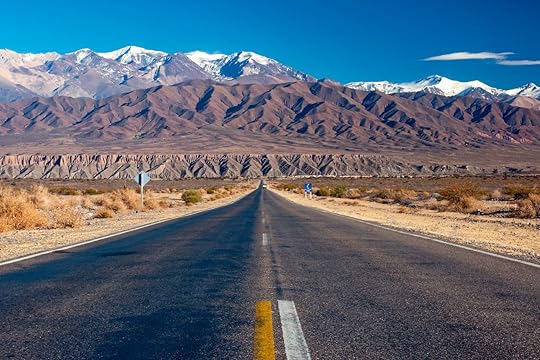
If you’re thinking that this sounds ideal for a road trip then you’d be absolutely right. Winding through the province is Argentina’s mythical Ruta 40, a national highway that stretches some 3,227 miles from the top to the bottom of the country. Salta’s section runs for about 220 miles and includes both paved and dirt track sections. You could cover it all in one long day of driving but you’d be missing out on a lot of fun if you did. For the most comfortable experience — and to ease your way around the dirt highway areas — we recommend going by 4WD drive vehicle or motorbike. Check out Cactus Rent a Car and Moto Alquiler Salta for options. Now here are some of the not-to-be-missed stops for your road trip in Salta, Argentina.
1. Cafayate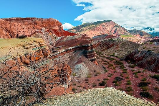
Photo: NiarKrad/Shutterstock
The first stop, and where the journey along Ruta 40 begins, is all about discovering the viticulture of northwest Argentina. However, before that there’s the small matter of arriving from Salta via the iridescent red-hued landscapes of the Quebrada de las Conchas (Canyon of the Shells). If you haven’t visited the Grand Canyon then this might just be the next best thing. Extraordinary rock walls shaped over millennia rise above a muddy river to create an otherworldly scene. It’s a three-hour straight drive through the canyon to Cafayate along Ruta 68, although you’ll want to pull over to capture the moment. Devil’s Throat, the Amphitheater, and the Toad are all worthwhile pit stops.
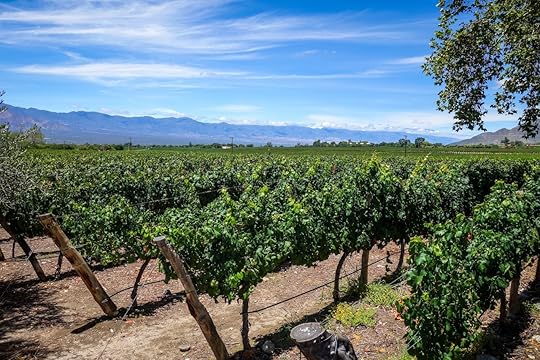
Photo: Daboost/Shutterstock
Cafayate itself is a busy colonial town in the Calchaquí Valley. It’s the heartland of Salta’s wine-making, as well. Dozens of bodegas, famous for their production of aromatic Torrontes white wines (and quintessential Argentine Malbecs), pepper the outskirts. Some, such as Bodega el Esteco and Bodega Vasija Secreta, are only a short stroll from the town center so you can park up and avoid any discussion about who’ll be the designated driver. You’ll probably want to stay the night here and can do so in style at the elegant winery-cum-hotel Patios de Cafayate.
2. San Carlos and Cachi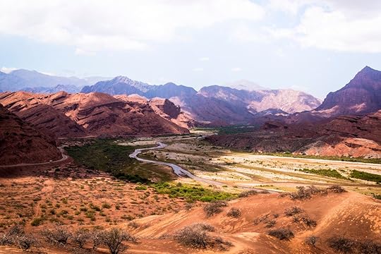
Photo: Lana Endermar/Shutterstock
From Cafayate, Ruta 40 meanders past vineyards and sleepy towns as it travels deep into the wild landscapes of the Calchaquí Valley. In about half an hour you’ll reach San Carlos, whose tree-shaded main square appears lost in time with its graceful arcades and white chapel. After another 30 minutes, the road climbs into the Quebrada de las Flechas (Canyon of the Arrows). With beige-colored cliffs rising up like arrowheads it’s easy to see how the canyon got its name. There are several rest stops and lookouts to get out and bask in the lunar-like setting.
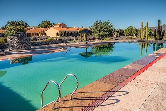
Photo: Colomé/Facebook
If you’ve driven enough for the day, stay at the nearby Estancia Colome. It’s a winery and hotel where the stargazing is superb and there’s the chance to ride horseback over high-altitude plains. Otherwise, continue for just over two hours along the rocky, cacti-lined highway and across bridge-less rivers to Cachi. Maybe it’s the adobe homes, cobblestone plazas, and Spanish church, or perhaps the snowcapped Andes and clean air, but Cachi really has that jaw-dropping sensation. Pass by the Pio Pablo Diaz Archeological Museum to find hundreds of treasures excavated in the Calchaquí Valley. It’s on the main square, which has its fair share of bars and restaurants with outdoor seating.
3. Abra del Acay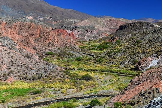
Photo: Pedro Carrilho/Shutterstock
We aren’t saying that you should incessantly show off about your vacations, but bragging rights are part and parcel of traveling. A little over 60 miles from Cachi, the meandering highway becomes a wondrous section of chicanes and switchbacks upon reaching Abra del Acay. At approximately 16,000 feet above sea level, this is among the highest mountain passes on the planet (only those in the Himalayas surpass it). It’s an arduous and isolated drive with some sheer drop-offs, so you’ll want to take it slow. Those up for the challenge, though, will find that the panoramic mountain views, including the summit of the almost 20,000-feet-tall Nevado de Acay, are unprecedented. Fill up with gas and pick up water and food supplies at La Poma, because afterward it’s just the thrill of you and the open road.
Tip: Check the road conditions with locals before setting off; it can be impassable due to summer floods and winter snowfall. Also, register your departure at La Poma police station; they’ll come looking for you if you don’t register your arrival after crossing the pass.
4. San Antonio de los Cobres
Photo: buteo/Shutterstock
At the northern end of the mountain pass, the route drops down into the Puna — the local name for the upland plateau in the Andes foothills — and toward San Antonio de los Cobres. This mining town is the last notable settlement on Salta’s Ruta 40 and a good place to stock up before deciding on your next destination. While here, you can gain an insightful overview of life in the Puna at the small Museo Regional Andino.
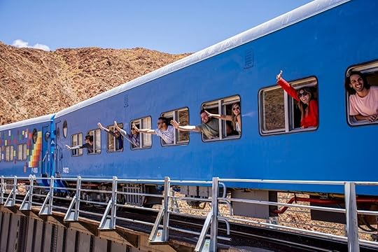
Photo: Tren a las Nubes/Facebook
Should you be in the mood for more adventure then consider adding a trip on the Tren a los Nubes (Train to the Clouds) to the itinerary. Departing from the town center, the train trundles around the arid mountain sides of the Puna to the Viaduct Polvorilla. There’s a brief break to snap photos from 200 feet above a ravine before riding back to town.
Note: A bus service travels from Salta to San Antonio de los Cobres to link up with the train. Visiting villages and natural wonders en route, it’s a recommendable alternative if you’re a train fanatic and pressed for time.
5. Salinas Grandes Salt Flats
Photo: Cesar Girolimini/Shutterstock
To get more of that ethereal and away-from-it-all feeling, swap Ruta 40 for Ruta 51 and drive to the Salinas Grandes. This white salt desert covers 82 square miles on the border of the provinces of Salta and Jujuy and is one of Argentina’s seven natural wonders. The backdrop of the Puna highlands does a fine job in adding to the mysticism. Visiting the salt flats is a simple task. A road, which resembles more a low-lying bridge, crosses the northern part. Pull over and stretch your legs with a walk over a vast salty ocean. Budding photographers will have a blast creating disproportionate shots and mirror images.
From Salinas Grandes it’s a three- to four-hour drive back to Salta, which demonstrates how easy it is to get lost in the Argentine wilderness while being so relatively close to urbanization. 
The post The ultimate road trip through wineries, salt flats, and colonial towns on Argentina’s Ruta 40 appeared first on Matador Network.


Canada to require all air travelers to be fully vaccinated

Canada will soon require all air, train, and cruise ship passengers to be fully vaccinated before traveling.
This announcement comes just after the country reopened its borders to fully vaccinated US travelers without the need for quarantine.
A statement from the Treasury Board of Canada Secretariat released on August 13, 2021, explains the new travel vaccination policy. All employees and passengers in the federal air, rail, and marine sectors will be required to be fully vaccinated “as soon as possible in the fall and no later than the end of October.”
“Canadians deserve to feel confident when traveling that the environment around them is safe,” said Canadian Transport Minister Omar Alghabra on Twitter. “We need to regain public confidence in travel.”
According to the Canadian Treasury Board, more than 71 percent of people in Canada are fully vaccinated, and more than 82 percent have had their first vaccination, but more than six million eligible people are still unvaccinated.
Air Canada responded to the announcement stating the vaccine policy is a “welcome step forward in the evolving measures to protect the health and safety of airline employees, customers, and all Canadians.”
The post Canada to require all air travelers to be fully vaccinated appeared first on Matador Network.
Here’s how you can get your vacation wardrobe from Rent the Runway

Want to be stylish on your next getaway and not lug a heavy suitcase? Well, now you don’t have to worry about packing as Rent the Runway (RTR), and TripAdvisor Plus have partnered up to offer a delivery service to send you clothes from the runway to your hotel room.
To score yourself some fashionable attire for your next getaway, you must sign up for a TripAdvisor Plus membership. The subscription regularly costs $99, but from now through December, you can receive $20 off your first year using code RTRPLUS, and you can also receive an exclusive 30 percent off any one-time rental.
Once you’ve booked a stay, you’ll receive an email with a promo code for RTR’s Closet Concierge. Then all you need to do is type in the zip code of your hotel and select an arrival date at least 48 hours before your arrival. RTR offers four- and eight-day outfit rentals.
RTR has styles from more than 700 brands. Currently, the website only stocks women’s and kid’s clothing and options for special events, office wear, and other occasions such as when you’re on vacation.
At checkout, use the code provided to you through email, make sure the shipping address is for your hotel, and inform where you’re staying that a package is on the way. When it’s time to return the clothing, place the items in the package they came in, switch the shipping labels, and return the items to a RTR drop-off location. It’s as easy as that. Your vacation wardrobe can be up-to-date and it won’t break the bank.
The post Here’s how you can get your vacation wardrobe from Rent the Runway appeared first on Matador Network.
August 16, 2021
The castles, palaces, and giant houses where the British royal family lives
The British royal family has a number of palaces, houses, and estates across the United Kingdom in its care. Some of these properties are used for weekend getaways, while others are country retreats for months at a time, and then there are the places that the royals officially call home for much of the year. From Queen Elizabeth II to Harry and Meghan, here’s where several members of the royal family live.
Queen Elizabeth II
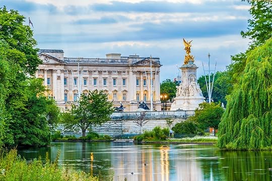
Photo: I Wei Huang/Shutterstock
Buckingham Palace: Built in the early 1700s, the palace didn’t become the official residence of the British monarchy in London until 1837. Buckingham Palace is primarily a location for administrative duties, such as official events and meetings, but it’s also where Queen Elizabeth II lives for most of the year. According to Royal.uk, Buckingham Palace has 775 rooms, including 19 State rooms, 52 Royal and guest bedrooms, 188 staff bedrooms, 92 offices and 78 bathrooms.
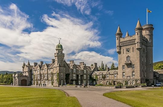
Photo: Byunau Konstantin/Shutterstock
Windsor Castle: The original castle was built in the 11th century and founded by William the Conqueror to solidify Norman power after their invasion. Several monarchs throughout the following years rebuilt, remodeled, and renovated the main palace and other buildings within the walls. Windsor Castle is still used by other royals today, such as for weddings and events, but Queen Elizabeth sets up an official residence here between March and April. She’s also known to spend her private time on weekends here. Windsor Castle is the oldest and largest occupied castle in the world, according to The Royal Collection Trust.

Photo: sloukam/Shutterstock
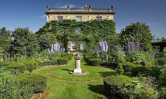
Balmoral Castle: Located in Scotland, Balmoral was bought in 1852 by Prince Albert for Queen Victoria. Since then, the 50,000-acre property has been a private holiday home for the royal family, and its halls have seen all members pass through — from Elizabeth herself down to William and Harry. It’s also where Charles brought Diana to meet his family for the first time.
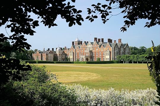
Photo: Sandringham1870/Facebook
Sandringham Estate: Sandringham has a long history with the monarchy. It was bought in 1862 for Prince Edward and is currently used by Elizabeth as a private country home where she spends her winters. The estate is where both her father, George VI and grandfather, George V, passed away.
Prince Charles
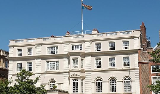
Photo: The Royal Collection Trust
Clarence House: Clarence House was built in the late 1820s and has been home to several generations of members of the royal family, including the Queen Mother Elizabeth, Queen Elizabeth II, and Prince Philip. Currently, it’s the official London residence of Prince Charles and his second wife, Camilla.
Photo: Highgrove Gardens/Facebook
Highgrove House: Highgrove house was built between 1796 and 1798 and came into Prince Charles’ possession in 1980. When Charles arrived, he made a number of renovations to the place to make it a home away from home in the country. It was where he and his first wife, Diana, spent their time on weekends, but it’s now the country home for him and Camilla.
Prince William
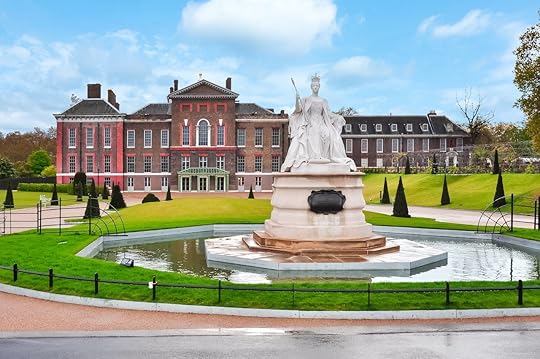
Photo: Mistervla/Shutterstock
Kensington Palace: Built in the early 15th century, Kensington Palace didn’t become an official royal residence until 1689. It was where Queen Victoria was born and lived during her childhood, and now it’s the London residence of Prince William and Kate, and their kids George, Charlotte, and Louis.
Prince Harry
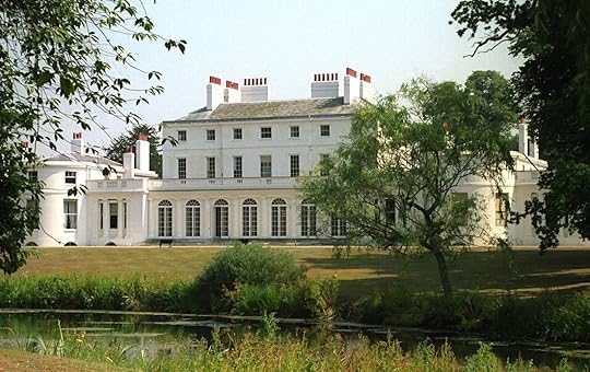
Photo: The Royal Household
Frogmore Cottage: Frogmore Cottage’s construction finished in 1684 and was leased out by Henry VIII. In 1792, Queen Charlotte bought the lease so that she and her family could have a country retreat. A few centuries later, in 2018, Prince Harry and Meghan had their wedding reception here and later moved in before the birth of their son Archie. The pair now live in California in the US, and reportedly opened their Windsor home to Princess Eugenie and her husband Jack while Eugenie was expecting her first child.
Princess Anne
Gatcombe Park: Queen Elizabeth purchased this late 18th-century country estate for her daughter in 1976, just six miles away from Highgrove House. Since then, it’s been the primary residence for Princess Anne and her family.
Prince Edward
Bagshot Park: Having been in the royal family since the beginning, the original building on this property was built in the 15th century and later demolished toward the end of the 17th century. The current building’s construction was completed in 1879 and used by various royals until it passed to Prince Edward and his wife Sophie in 1999 after their wedding.
Prince Andrew
Royal Lodge: The site that the lodge sits on goes back to the 15th century, and the property on it (known by various names throughout the years) passed through several occupants before landing in the hands of King George IV. A later royal had much of the site demolished except for a conservatory, which was also used by Queen Elizabeth II’s mother Elizabeth and King George VI as a country retreat. After Elizabeth’s passing in 2002, Prince Andrew moved into the lodge in 2004 with his ex-wife Sarah and daughters Beatrice and Eugenie.
The post The castles, palaces, and giant houses where the British royal family lives appeared first on Matador Network.
Why Route 66 makes for the best sports-focused road trip in America
Just so you know, Matador may collect a small commission from the links on this page. See our full Advertiser Disclosure here.
Route 66 is America’s most famous road. Some people take it for the history, others take it for the art, and many take it because Route 66 has an outsized reputation in a country in love with the great American road trip. What’s often left out of the conversation, however, is Route 66’s strong connection to another beloved American pastime: sports.
Ron Clements new book, A Sports Fan’s Guide to Route 66, puts athletics of all kinds front and center from the highway’s start in Chicago to its end in Santa Monica. There are NASCAR tracks up north, rodeos in the Southwest, and golf just about everywhere. And Clements doesn’t leave out the natural wonders, small towns, and quirky art that make Route 66 what it is today.
After reading the book, it’s hard to understand why sports don’t get the same amount of attention that’s lavished on other aspects of Route 66. The road is bookmarked by two of the most storied franchises in sports: the Chicago Bulls on one end and the Los Angeles Lakers on the other. Clements meticulously documents the in-between with just as much care. He notes the high schools and small colleges where athletes like Mickey Mantle, coaches like Rex Ryan, and many other famous figures in the world of sports got their start.
The book makes clear the argument that just like road trips today wouldn’t be the same without the history of Route 66, neither would sports without the many athletes who played along the same stretch.
Today, Route 66’s practical role is over. Five interstate highways — I-55, I-44, I-40, I-15, and I-10 — replaced Route 66, and it was officially decommissioned in 1985. Still, nostalgia and a long list of worthy stops drive people to this bastion of car culture. Using A Sports Fan’s Guide to Route 66 as a guide, you’ll find that the Mother Road is a bastion of sports culture, too.
The book covers every state along the route (Illinois, Missouri, Kansas, Oklahoma, Texas, New Mexico, Arizona, and California) in 300-plus pages featuring full-color photos and plenty of tips on where to stay, what to eat, and what to do. While it’s a pleasure to read through and find stats, historical notes, and cultural discoveries on each page, it is at heart a guide. The book is something to keep in the car for reference — a personalized handbook that can deliver more than what you could find with even the best of Google searches.
I caught up with Clements to learn more about the many miles he drove and the best stops he took while putting together the first sports book on Route 66.
This interview has been edited for clarity and length.
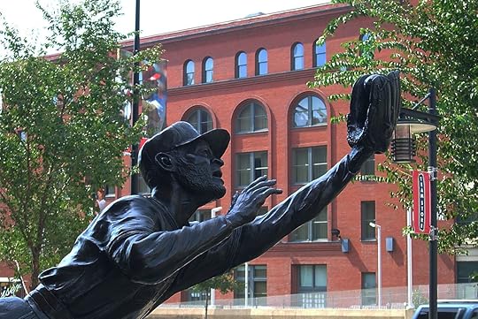
Photo: Frank Romeo/Shutterstock
Big cities (especially at the start and stop) with pro sports teams seem like easy and predictable inclusions. What would you say is the biggest and most historic sports team along Route 66?
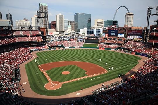
As much as it pains me to say as a Milwaukee Brewers fan, I would have to say the St. Louis Cardinals are the most historic pro sports team along Route 66. It’s the most successful National League franchise with 11 World Series championships and a slew of Hall of Famers. That’s no slight to the other pro sports teams in Chicago, St. Louis, Oklahoma City, or Los Angeles, but only the LA Lakers have had a similar history of success. But the Lakers began in Minneapolis and share an arena with two other teams. The Cardinals ARE St. Louis, which is maybe the best baseball city in the country.
What are your favorite small towns that made the cut, and what sports or sports culture connection makes them your favorite?
Pontiac, Illinois; and Tucumcari, New Mexico; are popular with Route 66 travelers because they both embrace the Route 66 culture. The signage is everywhere, and the towns’ museums are great. Both towns also have rich sports histories. Pontiac hosts the oldest holiday high school basketball tournament in the country, and Tucumcari has one of the nation’s best college rodeo programs. Both Pontiac and Tucumcari high schools also have a long history of sports success, so there’s a little of something for everyone in each. Seligman, Arizona, is also an endearing Route 66 town but doesn’t offer much in terms of sports because the high school’s heyday coincided with the height of Route 66.
There’s a great diversity of sports you included. Were there any that surprised you or particularly stood out?
I knew of a couple of rodeo arenas along Route 66, like in Cuba, Missouri, and Amarillo, Texas, but I didn’t realize how big rodeo is between Cuba and Williams, Arizona. And then there’s the aforementioned Tucumcari with its fall slate of rodeo, highlighted by the October National Intercollegiate Rodeo Association (NIRA) event at the Quay County Fairgrounds the same weekend as the Fossil Day Festival. Discovering the many rodeo arenas along the Mother Road was one of the more surprising things of the trip.
What was your research process like? How many miles did you go?
We did the entire route, from Chicago to Santa Monica, so we did about 2,500 miles and then some. We took two months to travel the entirety of Route 66 in the fall of 2019, and I attended several games, both as a fan and as a credentialed media member.
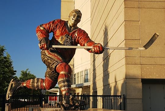
Photo: James Kirkikis/Shutterstock
The first sporting event was a Chicago Blackhawks game on September 25, and the last was a UCLA basketball game. The research on the professional teams and NCAA Division I universities was relatively easy because there is so much information out there. The smaller colleges and the high schools were a little more difficult, but it helped to speak with people and peruse the state high school athletic associations’ records. The Illinois High School Association (IHSA) is one of the best in terms of records being available online. A Sports Fan’s Guide to Route 66 is loaded with about 60 interviews, and those interviews not only add to the uniqueness of the book but definitely helped with the research for it.
It’s easy to get cliche about the power of sports to bring people together, but do you see any deeper truth to it after looking at the sports along Route 66?
Sports do bring people together, certainly, and that is definitely true at the high school level – especially in smaller towns.
One thing I wrote in the book and I’ve mentioned to people as I tell them about A Sports Fan’s Guide to Route 66 is that if they want to meet locals and learn more about the community through which they’re driving, they should attend a high school sporting event. These games have people in the stands who have lived in the same town for decades. There are septuagenarians and octogenarians whose kids and grandkids have long graduated and moved on from the school, but they still attend games because it’s part of the community fabric. That is something truly unique to small-town America.
Can you explain more about the many high school sports you cover in the book?
A Sports Fan’s Guide to Route 66 is the first-ever sports-related book about Route 66, and I wanted it to be as thorough and comprehensive as possible. Small towns are part of the Route 66 allure for some people. I have seen social media posts about people wanting to avoid the big cities as they travel down America’s Main Street, so I knew small towns were an endearing aspect of the route for many.

Photo: B. Franklin/Shutterstock
I grew up in a small city, and I love high school sports. When I began as a sports writer, I was covering high school athletics. The games are fun. The fans are into it because they’re the friends, parents, grandparents, aunts, uncles, and siblings of the athletes. The United States stands alone as a nation that holds amateur athletics in such a high regard, and I didn’t want to leave that out of the book. Someone traveling from Germany or Japan might not understand why college and high school sports are so popular here, and that’s something I wanted to help explain.
What do you believe is the through line that connects the sports along Route 66 beyond the road itself?
Each city has its own personality in terms of sports, but every Los Angeles Dodgers fan should travel Route 66. Each level of Dodgers baseball can be found along Route 66 – Single A in Rancho Cucamonga, California, Double A in Tulsa, Triple A in Oklahoma City, and then the MLB team in Los Angeles. There are two other Double A teams that play in the same league as Tulsa, so fans could see the Drillers play in Springfield, Missouri, and Amarillo. They could also see the LA Dodgers play the Cardinals in St. Louis or the Cubs in Chicago.
Which state do you feel has the most to offer for sports along Route 66?
Because of the terminus cities of Chicago and Los Angeles, I’d probably have to go with Illinois and California. Each major pro sports league is represented in the Windy City and LA, but you also have horse tracks, auto tracks, NCAA Division I and II universities, dynastic high school programs, and many golf courses along Route 66 in each state.
Oklahoma competes with the much bigger cities and more population of California. Do you think that’s a result of how long the road goes through Oklahoma, or something about the state’s connection to sports overall?
I think Oklahoma stands out because Route 66 goes directly through the state’s two largest cities. That’s something you don’t see in the other states. You’ve got Chicago in Illinois, but Route 66 doesn’t go through Peoria. You’ve got St. Louis in Missouri, but not Kansas City. Amarillo is nowhere near the size of Dallas or Houston in Texas. Route 66 is hours north of Phoenix in Arizona. And then in California, it’s just Los Angeles and not the other Golden State metropolises. But in Oklahoma, Route 66 is part of the identities of Tulsa and Oklahoma City. Route 66 literally runs along the campus of the University of Tulsa and goes through downtown OKC. It doesn’t hurt that sports teams at every level in those two cities have been successful.
Keeping with the car theme, what were your favorite Route 66 racetracks that you came across and why?
I’m admittedly not a big auto racing fan, but I’d have to go with Chicagoland Speedway and Route 66 Raceway outside of Joliet. Speaking with the track president there and hearing the passion he has for the sports of stock car and drag racing, it was hard not to love the place. Unfortunately, 2020 had an adverse effect on the tracks’ schedule, but hopefully, brighter days are ahead.
Golf seems to be everywhere. Do you think that it’d be a worthy trip for a serious golfer to try and complete every course along Route 66?
I included golf courses for this very reason. Living full-time in an RV for the last three-and-a-half years, I have met countless people who have been on golf road trips. When I first started to notice golf courses near Route 66 in Illinois, I knew I had to mention them in A Sports Fan’s Guide to Route 66. Any serious golfer would have a blast traveling Route 66 and playing the many courses found along it.
The post Why Route 66 makes for the best sports-focused road trip in America appeared first on Matador Network.
The most expensive airport taxis in the world
After a long plane ride and the tedious process of collecting your belongings, it can be tempting to bypass public transportation (if it’s even available) and be ready to sit back and enjoy the private comfort of a taxi instead. Not all airport taxis around the world are created equal, though. The website FleetLogging has released a study that showcases the price of getting from the airport to the city center by taxis in major cities around the world. After looking at 1,249 different airports, these were its findings about the most expensive and cheapest airport taxis in the world.
Japan leads the charge with eight out of ten of the most expensive airport taxis in the world. A ride to Hiroshima or Oita city center from their respective airports will cost you a whopping $165 — the most expensive in the world.
The 10 most expensive airport taxis in the world:
Hiroshima Airport in Hiroshima, Japan — $165Oita Airport in Oita, Japan — $165New Chitose Airport in Sapporo, Japan — $150Chubu Centrair International Airport in Nagoya, Japan — $148Southend Airport in London, England — $146Narita International Airport in Tokyo/Chiba, Japan — $145Oslo Airport-Gardermoen in Oslo, Norway — $145Kagoshima Airport in Kagoshima, Japan — $135Shizuoka Airport in Shizuoka, Japan — $135Kansai International Airport in Osaka, Japan — $129The most expensive airport ride in the US is from the Savannah/Hilton Head International Airport to Hilton Head due to its lengthy ride and toll road fees.
Most of the cheapest airport taxis are located in Africa and Central Asia. From the Cadjehoun airport in Cotonou Benin, a taxi ride will only cost you $1. Airport taxis from Nefta International Airport in Tozeur, Tunisia; Bluefields Airport in Bluefields, Nicaragua; and Puerto Cabezas Airport, in Puerto Cabezas, Nicaragua will also cost you only $1. In this study, 55 airport taxis are also classified as very cheap with $2 taxi rides.
The cheapest rides in the US are $10 from Richmond International Airport to Sandston (Richmond), Virginia, and Bangor International Airport to Bangor, Maine.
To see the complete list of the most expensive and cheapest airport taxis in the world, check out FleetLogging’s study.
The post The most expensive airport taxis in the world appeared first on Matador Network.
5 Italian food taboos you’re probably breaking

“Buon appetito,” the server said as he set a steaming dish of tagliatelle ai porcini, in English, tagliatelle with porcini mushrooms, atop the flowered tablecloth in front of me.
“Grazie,” I said, reaching for a metal dish of Parmesan cheese. The waiter’s pleased expression morphed into one of alarm.
“Signorina, non si puo!” he exclaimed, or “Miss, you can’t do that!” He seemed to break into a light sweat.
Baffled, but not wanting to further torture the server, I relinquished the Parmesan cheese and focused on my glass of bubbly Pignoletto. The server let out a sigh of relief and scurried away.
My table mate leaned over her plate of tagliatelle al ragù. “Do you think I can add olive oil to this?” She asked in a hushed voice.
“Maybe it’s better not to risk it,” I said.
I would later learn my friend had asked a legitimate question about her ragù: Italians believe it’s already rich and oily enough, and therefore, additional oil isn’t necessary. Many Italians also think cheese ruins the delicate flavor of mushrooms, like porcini.
After several years living in a medium-sized town called Faenza, I have learned to respect Italian food customs even if they don’t always make sense to me. Once, while preparing a simple dinner of penne pasta with tomato and Parmesan cheese with my Italian boyfriend, I mentioned I wanted to add black pepper and oregano, but my boyfriend shook his head.
“We should choose either pepper or oregano,” he said.
“Have you ever added them both?” I asked. It had never even occurred to American me not to.
“I would like to savor one or the other,” he replied.
In Italy, each element is much more significant than a simple ingredient in a pantry. There are only two other things I’ve heard regularly referred to as a religion in this country (besides Catholicism): soccer and food.
I once witnessed a table of about 20 Italians enter into a heated debate about preparing ragù. We were in Bologna, the birthplace of this meaty sauce, and the group was talking about ingredients. An older woman with a cascade of white hair said she included carrots and celery, while a man from a nearby town stated he only added onions. Someone mentioned adding a bit of cream to the sauce, and the whole table erupted into a variety of reactions ranging from affirmation to shock.
It’s not easy to navigate the endearingly strict customs surrounding Italian cuisine, also because what is considered correct may vary by region or town (as in the case of ragù). However, to respect tradition, there are five food rules that Italians believe should always be observed at the dinner table. Here’s what you need to know.
1. Never add cream to carbonaraSpeaking of cream or milk, adding it to carbonara is an absolute no-no. Garlic and onions are also forbidden in this classic pasta dish. The only ingredients should be spaghetti noodles, pepper, Parmesan or pecorino cheese, egg, and pancetta.
Better even than pancetta, another diced meat called il guanciale di maiale, or simply guanciale. Why? Guanciale is fattier than pancetta, which makes the dish even more delicious. Guanciale is also tied to the region of Lazio, home to both Rome and carbonara. The carbonara closest to Italian tradition also uses pecorino cheese, since it also originates from Lazio.

Photo: Nata Bene/Shutterstock
I discussed carbonara with an Italian friend and our favorite bartender, Luca. Both admitted they add a bit of cream to their carbonara when they make it at home. I was surprised.
Luca raised both his hands and shrugged, a typical Italian expression that means something like, “Oh well!”
“What can I say? In public we swear the recipe should be exactly so and in private, we do what we want,” he said.
2. Fish and cheese shouldn’t be served togetherThe majority of Italians swear that cheese shouldn’t touch a fish or seafood dish. Sprinkling Parmesan cheese atop, for example, spaghetti with clams or roasted bass, is discouraged. Some even insist that secondi, or second courses (typically meat and fish), should not be accompanied by contorni (side dishes) that include cheese (like Caesar salad). This food rule stems from respect for the fish or seafood, whose delicate taste will be overpowered by the stronger flavor of the cheese.
3. Each course should be served separatelyItalians take great pleasure in long, drawn-out meals where each dish has its proper time in the spotlight. The primo, or first course, showcases foods like pasta, risotto and soup, followed by the aforementioned secondo and contorno, dolce (dessert), coffee, and digestive liquors. The only two items allowed to grace the table simultaneously are the secondo and contorno.
In Italy, side salads are also considered contorno. In recent years, and especially in touristy places, the staff has become used to visitors who prefer eating salads first or even request that all the food arrives at once. However, in order to dine like an Italian, the courses should be separate, and salad should be nibbled later to help digestion.
Eating multiple foods off the same plate may also raise either alarm or confusion among Italians. Even at buffet-style breakfasts, which serve more “American” items like eggs and pancakes, Italians make several trips in order to keep sweet and savory foods apart.
4. Spaghetti and meatballs don’t go together
Photo: KP Suwannasuk/Shutterstock
Dishes like spaghetti and meatballs not only don’t exist in Italy, but they don’t make logical sense to an Italian. Spaghetti is served during the primo (first course) topped with clams or tossed in carbonara sauce; meatballs, called polpette and composed of meats or vegetables, are reserved for the second course.
It is also not common to eat bread with pasta. After the pasta is finished, bread is used to “fare la scarpetta,” literally translated as “do the shoe.” In other words, the bread is used to scoop up every last bit of delectable sauce before moving onto the second course.
5. Coffee should be timed perfectly (and avoid cappuccinos after a certain hour)Among the most ubiquitous elements of Italian cuisine is the cappuccino. But this seemingly simple caffeinated beverage is anything but, and there’s a certain way to order coffee in Italy and not look like a tourist.
When it comes to cappuccinos, don’t order one at the end of a multi-course dinner. Or while still finishing a lambchop or even penne all’arrabbiata. Coffee should be ordered after the meal’s final course.
The point of coffee at that juncture is, like salad, to encourage digestion, which explains why cappuccinos are considered “too heavy” for this service, with their layer of frothed milk. Thus, a caffè normale (or simple shot of espresso) is the best choice. If straight espresso is too strong, order a caffè macchiato which will arrive with a dollop of steamed milk on top.
The argument about heaviness also plays into why Italians don’t drink cappuccinos after noon. Instead, “lighter” coffees should be drunk in the afternoon, especially during the hot summer. Very traditional Italians may not even drink cappuccinos after noon in the winter.
Cappuccinos also come in just one size; there is no such thing in Italy as a small, medium or large cappuccino.
The post 5 Italian food taboos you’re probably breaking appeared first on Matador Network.
Hug a tree and you could win a trip to northern Finland
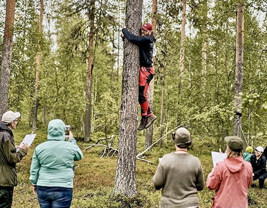
Finland has just added one more crazy world championship to its roster — and this one is all about the planet. As if wife-carrying tournaments, mud soccer, and international air guitar competitions weren’t enough, it’s now time for the second annual TreeHugging World Championships.
Taking place in Levi, Finland, on August 21, spectators will be able to watch and comment via several social platforms, including Facebook and Twitter. There’s also the opportunity to participate in a virtual tree-hugging event and be eligible to win a trip for two to this stunning corner of Finnish Lapland.
The event is hosted by HaliPuu, a family in Finland’s northern reaches dedicated to protecting and preserving their forest. The live competition is in HaliPuu forest — and is invitation-only due to COVID — and will take place on Saturday, August 21, 2021, at 12 noon CET.
Those participating in this event are current residents of Levi. Given that Levi is also a cool ski and resort area, it’s not surprising these residents will be representing their home countries of Ukraine, Spain, Italy, Finland, Germany, Switzerland, Sámi-land (Finnish Lapland), Russia, Scotland, and the US.
Photo: HaliPuu
Events in the live competition will include speed hugging, dedication, and freestyle. The judges of this year’s competition will be HaliPuu-Pappa Kaarle Raekallio, Ritva Saarensalmi, Heikki Hamunen, and Misha del Val. The winner will receive the title of TreeHugging World Champion 2021 and a private Arctic Cocooning experience in the serene forest with the HaliPuu family.
In the online event, which began on August 13 and runs until August 28, you can qualify by uploading a photo of yourself, your family, or friends hugging a tree and posting it to Instagram, tagging #TreeHugging2021 and #HaliPuu. In your post, include the coordinates of the tree and include a description of why you love that specific pine or oak, or whatever it may be, or why you like tree-hugging in general.
The online winner will be announced on August 29, during HaliPuu’s weekly broadcast at noon, and will receive an invite to join the live competition next year. They’ll also receive an all-exclusive trip for two, including round-trip train tickets in the sleeping cabin of an overnight train from Helsinki to Rovaniemi, a one-week stay in Levi, and a private cocooning experience in the HaliPuu forest.
Watch the live event and decide for yourself weho has the best tree-hugging vibes by watching via Happs, YouTube, Facebook, Twitter, or Twitch. More details on the championship are available online.
And don’t forget to enter the virtual competition as well — a good tree hug might be just what you need right now.
The post Hug a tree and you could win a trip to northern Finland appeared first on Matador Network.
Where to Instagram in Vegas
Between the Bellagio fountains, the replica Eiffel Tower, and the faux Venice canals, Las Vegas is an Instagrammer’s paradise — not to mention the iconic “Welcome to Las Vegas” sign and the Elvises on every corner happy to snap a selfie with you for a few bucks. There are so many other wonderfully weird spots that might as well have been designed just for social media. If you’re at the top of your ‘gram game, get deep into the city that locals know and love to see and snap: the lesser-known side of fabulous Las Vegas. These are the most photo-worthy spots in Vegas off the strip.
1. The Neon Museum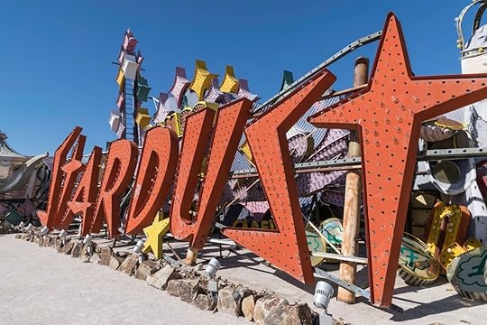
Photo: Rosemarie Mosteller/Shutterstock
The Neon Museum is hardly what you could call “off radar” at this point — it’s probably one of the most Instagrammed locations in Las Vegas, on or off the Strip, for good reason. The “Neon Boneyard” is one of the most eerily beautiful spots in Vegas, a collection of restored old neon signs salvaged from the hotels, motels, restaurants, and other shuttered locations that have their place in Sin City history. At dusk, the dramatic natural desert lighting in combination with the backdrop of these vintage signs makes for the most amazing pictures, which is why you’re almost always guaranteed to see a wedding party or fashion shoot happening here.
2. Downtown Las Vegas murals
Photo: Kobby Dagan/Shutterstock
Massive murals that covered whole sides of buildings were already seen around downtown Las Vegas before the Life Is Beautiful music and art festival first launched in 2013, but since then, they have exploded — public art is a huge component of the festival, and each year more than a dozen new murals appear around downtown as a result of the international street artists the festival brings in. Artists like Banksy, Shepard Fairey, D*Face, and more have left their mark, and as a result, downtown Las Vegas is basically a massive outdoor art gallery.
3. Lyft + Fired Up Management Art Park
Photo: Park On Fremont/Facebook
Just to the east of the Fremont Street Experience’s LED canopy is Fremont East, aka the area where the locals hang out when they go downtown. What used to be an empty parking lot right next to the popular restaurant and bar Park on Fremont is now the Lyft Fired Up Management Art Park — a park of large sculpture and installations sponsored by Lyft.
4. The porte-cochère at the Plaza Hotel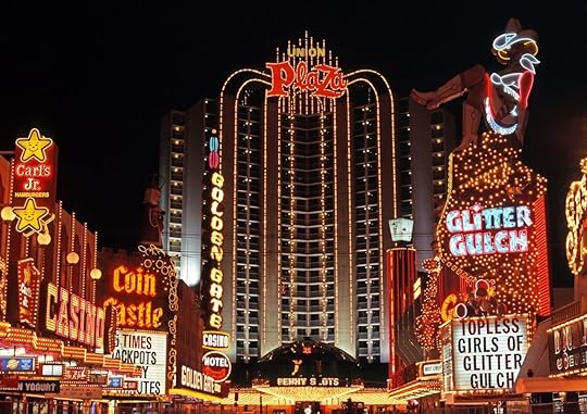
Photo: Caron Badkin/Shutterstock
The Plaza Hotel marks the western edge of Fremont Street, and its entrance is appropriately glitzy for those coming fresh off Fremont. The circular porte-cochère looks like a thousand paparazzi flashbulbs all going off simultaneously. For even more camera-ready glam, head up to Oscar’s inside the glass dome perched above the porte-cochère, one of the most beautiful dining rooms in Vegas (and that’s a high bar) with the absolute best view of the Fremont Street Experience.
5. Selfie room at Corduroy
Photo: Corduroy/Facebook and Corduroy/Facebook
The East Fremont bar Corduroy knows its audience, which is why there is a whole dedicated selfie room called “The Lightbox” inside with perfect photo lighting for you and your friends to stage the perfect Vegas-night-out selfie.
6. New showgirl signs on Las Vegas Boulevard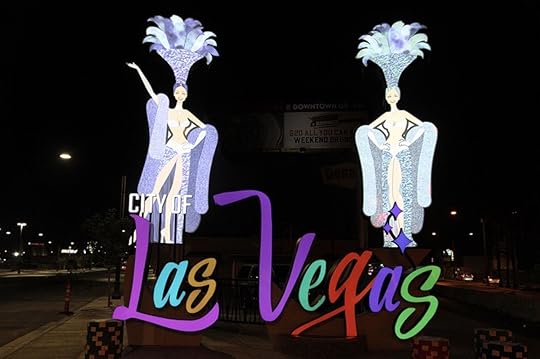
Photo: Fremont Street Experience
Everyone gets a photo of the famous “Welcome to Las Vegas” sign on the south side of the Strip, but just a couple of years ago, the City of Las Vegas introduced a brand-new sign featuring images of Vegas’s iconic showgirls at the “gateway to downtown,” the intersection of Las Vegas Boulevard and Main Street.
7. Abbey Road Crossing
Photo: Abbey Road Crossing Las Vegas/Facebook
Right in front of the historic El Cortez Hotel is a replica of the rainbow-colored Abbey Road Crossing in London, made famous by the Beatles on the cover of their 1969 Abbey Road album. Most people miss it walking by, but with the neon lights of the El Cortez in the background, this is a spot that just begs to be photographed.
8. “Big Rig Jig” in the Fergusons courtyard
Photo: Jason Ogulnik/Shutterstock
Head a little further down East Fremont towards Atomic Liquors and keep an eye open for this crazy sculpture originally created for Burning Man. The structure looks like a semi-truck upended and twisted all around on top of itself. It’s located in the courtyard of the historic old Fergusons Motel.
9. Peter Pan Motel signView this post on InstagramA post shared by AimlessAdventures (@aimlessadventures) on May 22, 2019 at 9:22am PDT
While the Peter Pan Motel remains vacant, the sign is still an iconic piece of old Las Vegas. Slowly but surely, some of downtown Las Vegas’ old motels have been getting renovated and reopening as affordable options, so we can hold out hope that this motel and its glorious sign will see new life yet.
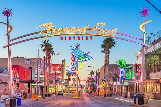
10. Fremont Street East
Photo: Sean Pavone/Shutterstock
Fremont East is experiencing a revival much like other parts of downtown including the Arts District. The welcome sign here is arguably more photogenic than anything on the strip, with the added bonus of actually signifying something born and bred in Vegas instead of New York, Venice, or Hollywood.
11. A Little White Wedding Chapel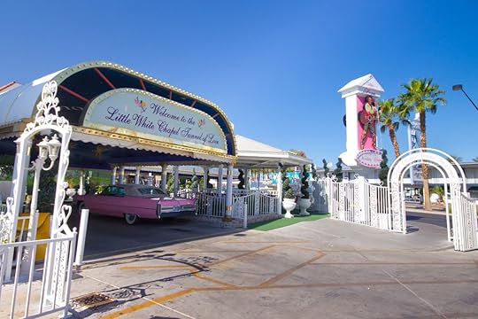
Photo: littlenySTOCK/Shutterstock
You can’t go to downtown Las Vegas without peeping at one of the many storied and historic wedding chapels. There are several such wedding chapels located on Las Vegas Boulevard, and they all have their own, points of interest, but only A Little White Wedding Chapel has the “Tunnel of Love,” a drive-through wedding tunnel where couples can say their nuptials in the chapel’s own pink Cadillac with Elvis officiating. You’ll definitely want a photo of the tunnel’s faux Sistine-ish ceiling.
12. Commercial Center District World Village
Photo: Commercial Center District World Village/Facebook
People come from all over the world to Las Vegas. Some never leave, and the best place in the city to actually take in a diverse collection of global culture is the Commercial Center District World Village. Located south of the Strip and Fremont Street, the area is home to restaurants, shops, and entertainment with roots spanning the world. The district is popular with artists and the city’s LGBTQ+ scene, and is home to much of the best dining in Las Vegas. Hanging out here is akin to leaving the flashy Vegas behind and stepping into a reality that is equally Instagrammable and engaging without being a facade. The food and shopping are amazing, but of particular note are the eloquently painted trash dumpsters that are sure to fire up a conversation in the comments of your post.
The post The 12 most photo-worthy spots in Vegas off the Strip appeared first on Matador Network.
Where to travel in September for the best outdoor adventures

September is a month of denial. Many are loath to admit that summer is over and still cling desperately to those final sunny days. Others are more eager for fall, prematurely donning flannel shirts, scoping out apple orchards, and pre-ordering pumpkin spice lattes the second the calendar turns to September 1. Seasonal biases aside, September is actually the best of both worlds, and one of the best months of the year for a vacation. With the most intense summer heat behind us and the chilly autumn weather still ahead, this is the month to take that outdoor vacation you’ve been putting off. From mountain biking in Vermont’s rugged Northeast Kingdom to stargazing in the Texas Hill Country, these are the best regions to visit in September for an outdoor adventure.
Northeast Kingdom, Vermont
Photo: NEKVT/Shutterstock
The Northeast Kingdom might sound like a separate nation within Vermont, but its name actually represents the pride those who live there take in their remote homeland. The kingdom is composed of the rural, bucolic counties of Essex, Orleans, and Caledonia, and is defined by its small towns, wild landscape, and interesting characters you’ll meet when you visit. It’s also one of the best regions in New England for uncrowded biking trails. Everyone knows summer in New England can get pretty humid, making September the perfect time to visit.
How to get there: Anyone visiting the Northeast Kingdom from outside New England will want to fly into Burlington international Airport, and then drive about two hours east to the Northeast Kingdom. If you’re traveling from within New England, Boston has direct flights to Lebanon Municipal Airport in West Lebanon, New Hampshire, which puts you an hour’s drive from the Northeast Kingdom. You could also make the entire journey by car, as Boston is just a three hour drive from the region, and September is an ideal time of year to enjoy the changing foliage.
Where to go mountain biking: The Kingdom Trail network is one of the most beautiful biking trails in New England, and also one of the least visited. Located in East Burke, the network contains over 100 miles of trails for all ages and ability levels. There are skill parks, technical single tracks, more relaxed double tracks, excavated flow trails, and even pedestrian trails for those who’d prefer to walk. The entire network is interconnected, making it convenient to traverse multiple trails during a single visit as you pass through some of Vermont’s most rugged scenery.
Pocono Mountains, Pennsylvania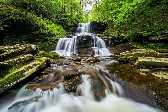
Photo: Jon Bilous/Shutterstock
The Poconos in northeastern Pennsylvania have the rare benefit of immersing visitors in nature while still being just a day trip away from a major urban area. Under two hours from Philadelphia and New York City, the Poconos Mountains are known for a diversity of outdoor adventure experiences, including whitewater rafting, waterparks, skiing, and beaches. The mountains are probably best known for hiking, however, especially in Ricketts Glen State Park.
How to get there: The Poconos are around a two hour drive from both Philadelphia and New York, and those are also the access points for travelers from elsewhere in the country. Flying into Philadelphia and then driving to the mountains is probably your best bet. There are also busses running between the airport and the mountains. Pocono Mountains Municipal Airport is another option, located under a half hour from your destination, though direct flights here are rarer and often more expensive.
Where to go hiking: Ricketts Glen State Park is the Pocconos’s premier hiking destination. The park is filled with hiking trails running alongside waterfalls, including the seven-mile Falls Trail loop that allows you to see 21 waterfalls along the way. There’s also a shorter Beach Trail that brings you around Lake Jean, the Grand View Trail that takes hikers to the highest point on Red Rock Mountain, and the difficult Mountain Springs Trail that winds past the old Lake Leigh Dam and down to Bowmans Creek.
East of Ricketts Glen, Bushkill Falls is another great option for hiking in the Poconos. This private hiking area is also home to several waterfalls, the tallest of which is 100 feet high.
Long Island, New York
Photo: James Kirkikis/Shutterstock
A Long Island vacation might call to mind ritzy images of summer in the Hamptons, but fall is the best time of year to visit Long Island. And no, you don’t have to drop Hamptons levels of money. New England often hogs the fall scenery spotlight, but Long Island — particularly the North Fork — is filled with vineyards, pumpkin patches, and harvest festivals that rival anything you’d find in Massachusetts.
How to get there: MacArthur Airport is the largest regional airport on Long Island, though it’s probably easier and cheaper to fly into New York City via LaGuardia or JFK. You could also take the ferry from New London, CT, across the Long Island Sound to Orient Point.
Where to find fall festivities: Home to over 55 vineyards, the North Fork has no shortage of alluring options for visitors. Main Road, which stretches inland from Orient Point, is lined with farms, fruit vendors, pie stands, and vineyards.
Hallock’s Cider Mill is one of the most famous farms on Long Island, and is known for its key lime pie, jams, cookies, and eccentric gnome houses in the fantasy-themed yard. Garden of Eve Organic Farm and Market is perfect for those looking to do some picking, with sprawling strawberry, blueberry, blackberry, corn, and pumpkin fields. There’s also the Fun Fields for children, with farm animals, a bounce pad, tube slide, and pedal kart track. Those looking to ring in fall by imbibing should check out Bedell Cellars, a family-owned vineyard operating since 1980. Its picturesque grounds are defined by a mahogany pavilion with views of the lush vineyards and gardens, though there’s also a more intimate indoor loft with vaulted ceilings and a fireplace where you can sip in style. And if you happen to be visiting at the end of September, Harbes Family Farm is hosting a Pumpkin Harvest Festival on September 25 and 26, with live music, pumpkin picking, and musical hayrides.
Door County, Wisconsin
Photo: Nejdet Duzen/Shutterstock
Door County is situated on a peninsula jutting into Lake Michigan, and it has everything from picturesque fall hiking and biking trails to picnic areas, roadside farm markets, and apple cider. The best way to truly see it all is by renting a car (or driving your own) and road tripping through everything the county has to offer.
How to get there: The closest major airport to Door County is around two-and-a-half hours away Milwaukee. It’s probably best to rent a car at the airport, as driving is the most convenient way to explore the area. You can also get there by ferry (and take your car along for the ride). The Lake Michigan Car Ferry connects Ludington Michigan with Manitowic, Wisconsin.
Where to road trip: The Cave Point County Park at the south end of the peninsula is a great place to start your road trip. With views of the shoreline cliffs on Lake Michigan, the Cave Point Lakeside Trail is perfect for all skill levels and brings you through the park’s most lush scenery at a leisurely pace. The Black Trail is another option for hikers. Considered one of the best nature walks in the county, the trail loop starts at the Whitefish Dune State Park parking lot and winds around a section of coastline with views of Lake Michigan. Through the woods, you can glimpse the changing leaves. There are several picnic areas along the way where you can stop for the perfect fall picnic.
Along the way, make sure to sample the country’s best apple cider. Stop first at Lautenbach’s Orchard Country Winery & Market, a family-run market that has been producing fruit products since 1955, and known for its wide variety of hard cider flavors. Island Orchard Cider, at the northern end of the peninsula, is probably the perfect place to cap off your trip. The cider house has both indoor seating and an outdoor patio, flight tasting, and an extensive menu of specialty ciders.
Where to bike: There are also tons of prime biking routes for cyclists looking to hit multiple trails around the county. As you drive up the peninsula, the Country Road Q trail starts just north of Bailey’s Harbor, and winds north past the Mud Lake State Wildlife Area, Moonlight Bay, and North Bay. The forested route has great views of the lake and access to Cana Island. There’s also the option of taking the car ferry to Washington Island just off the northern tip of the peninsula, which is a great place to end your road trip. You can either rent a bike or use your own to explore historic churches, lavender fields, forests, and beaches on the island.
Great Smoky Mountains, North Carolina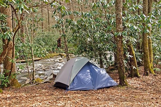
Photo: Wildnerdpix/Shutterstock
Seasoned campers might be comfortable camping all year round — even in the frigid winter months or in the burning summer heat. Those of us looking for a more comfortable, casual experience should camp in September, when the weather is cooling off but nature is still alive and colorful. The Great Smoky Mountains has a variety of backcountry and frontcountry campgrounds, which are a great complement to hiking the scenic trails and driving through the fall foliage.
How to get there: If you’re driving, the mountains are most commonly accessed via the Sugarlands entrance on the park’s north side, through Gatlinburg. There’s also a smaller, less-trafficked entrance south of Townsend, about 25 miles west of Gatlinburg. The closest major airport is Knoxville’s McGhee Tyson Airport, located an hour west of the mountains. Many travelers, however, use Asheville as a base, and might find the Asheville Regional Airport more convenient.
Where to go camping: The mountains have several campgrounds to take advantage of. Each campground has restrooms with toilets and running water, and each campsite comes with a fire grate and picnic table. Balsam Mountain Campground is one of the most popular, surrounded by streams and mountain views, and elk sightings are particularly common during the fall. Deep Creek, in the southeastern part of the park, is known for its vivid fall colors and access to several hiking trails. It’s also right next to a creek, making it perfect for a relaxing afternoon of fishing. Cades Cove is another popular campground, due to its hiking and biking trails, and the 11-mile Cades Cove Loop Road.The campground is in a valley surrounded by mountains, and wildlife like white-tailed deer, black bears, coyotes, groundhogs, turkeys, and other animals are oftens spotted here.There are also seven group campgrounds accommodating parties of eight or more, though trailers and campers are not permitted here — only tents.
Oregon Scenic Byways, Oregon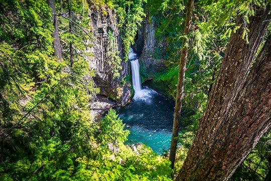
Photo: Stephen Moehle/Shutterstock
Fall is uniquely conducive to a trip based solely around sightseeing without having to burden yourself with the physical activity that usually comes with outdoor adventure. The season’s vibrant colors and trees full of eye-catching foliage make a sightseeing tour a great trip option — as long as you know where to go. The Pacific Northwest is known year-round for its natural beauty, though there’s nothing quite like Oregon’s Scenic Byways in the fall for sightseeing you simply can’t get anywhere else in the country.
How to get there: Since traveling the scenic byways requires a car, you’ll need to either rent one at an airport or drive your own. The state’s largest airport with the most rental options is in Portland, though regional airports in Bend and Eugene are also good options.
Where to do go sightseeing: Scenic byways are chosen for possessing unique natural, scenic, historic, cultural, recreational, or archeological qualities. It’s no surprise, then, that Oregon has 29 designated scenic byways throughout the state, each offering something slightly different. For autumn sightseers, the McKenzie Pass-Santiam Pass Scenic Byway should be first on your list. This byway starts in Sisters, and travels northwest on US-20 toward Santiam Pass. Along the way you’ll see Suttle Lake and Mt. Washington, as well as several ashen buttes from the pass itself. When you cross onto the McKenzie River Highway, you’ll have access to the McKenzie River National Recreation Trail if you want to stop for some hiking or biking along the river, or simply continue to see Sahalie Falls, which can be viewed from a parking lot. The Silver Falls State Park area also has several waterfalls, and red vine maples full of colorful leaves to really drive home that fall vibe.
To really plunge into the woodlands, drive the Rogue-Umpqua Scenic Byway starting in Roseburg. East of Roseburg you’ll drive through hills filled with oak trees, and farther on, hikers can take advantage of the North Umpqua Trail that winds through an old-growth forest. After you pass Toketee Lake on OR-138, you’ll be able to see Diamond Lake, Mt. Thielsen, and Mt. Bailey, followed by the Crater Rim Viewpoint with views of Crater Lake before plunging once again into the forest as you enter Rogue River-Siskiyou National Forest.
Texas Hill Country, Texas
Photo: Philip Arno Photography/Shutterstock
Travelers might not typically associate Texas with fall, but it’s the best season to have an outdoor adventure in the Lone Star State without worrying about the oppressive heat. The Hill Country forms the southeastern part of the Edwards Plateau, a remote and rural region of Texas that’s perfect for hiking, camping, and picnicking — especially in the fall.
How to get there: The easiest way to reach the Hill Country is by flying into San Antonio International Airport or Austin-Bergstrom International Airport. If you don’t have your own car you’ll probably want to rent one, as convenient public transit is lacking.
Where to have a picnic: Pace Bend Park in Spicewood, northwest of Austin, might as well be called “Peace” Bend Park for how relaxing it is. This remote peninsula on Lake Travis has nine miles of shoreline, picturesque rocky cliffs, and beautiful views of the water pretty much anywhere you set up camp. After your picnic, go swimming in the lake or just spend the afternoon sunbathing on the cliffs. Krause Springs, also in Spicewood, is a great option for those who want to feel immersed in nature. Surrounded by oak and cypress trees, you can picnic under the boughs in a relaxing shade, with views of a small waterfall pouring into a swimming hole. Blanco State Park, southeast of Austin, is a picnic area well-equipped with picnic tables and barbecue pits. Located on a long stretch of riverbank, there are plenty of private areas where you can set up and enjoy the view of waterfalls cascading into the river.
For a slightly different experience, have a night picnic at Enchanted Rock State Natural Area. The park is one of the best dark-sky locations in Texas, making it perfect for stargazing and viewing the Milky Way.
The post Where to travel in September for the best outdoor adventures appeared first on Matador Network.
Matador Network's Blog

- Matador Network's profile
- 6 followers

