
Matador Network's Blog, page 1010
September 19, 2019
Atauro Island, East Timor, travel

Atauro Island is a pristine paradise north of the main island of Timor-Leste. Timor-Leste, better known to some as East Timor, is the world’s fourth-newest country and the youngest one in Asia — founded after a bloody battle for independence from Indonesia that began in 1999. Although Timor-Leste’s sovereignty has been recognized internationally since 2002, the country and its beautiful islands, like Atauro, have yet to pop up on the world’s tourism radar. That won’t be the case for very long. Atauro Island is nearly devoid of beach clubs and tourists, but it offers incredible water-based and cultural activities. Here’s how to get there and why you need to visit this island before it becomes a mainstream destination.
About Atauro Island

Photo: Jennifer Lundt
Atauro Island lies 215.5 miles north of Dili, the capital of Timor-Leste. It’s a small island, just over 14 miles long, and home to under 10,000 people. Atauro lies in the middle of the famed Indonesian Throughflow, a warm ocean current that brings a rich assortment of nutrients south from the Banda Sea. These nutrients bestow Atauro with the richest reefs in the Coral Triangle, particularly significant given that this area is already considered the “Amazon Rainforest of the ocean.” In 2016 the prestigious title became official when a Conservation International team analyzed sealife surrounding the island and found an average of 253 reef fish species right off the island, making these waters the most biodiverse ever recorded. You read that right: not the Carribbean, the Maldives, or South Africa but a tiny island in a country that many people don’t even know exists.
The diving is vibrant and biodiverse

Photo: Atauro Dive Resort/Facebook
Because of the diverse reef ecosystems and warm waters, diving is what looks to be the driving force behind any coming boon to tourism on Atauro Island. Travelers who make the long journey to Timor-Leste can witness the underwater treasures firsthand. Dive sites surrounding the island include breathtaking wall drop-offs that plummet miles deep towards the ocean bottom, coral garden descending slopes, and fringing coastal reefs teeming with an abundance of varied aquatic fauna, some of which are exclusive to this location. In general, the water is also incredibly clear, providing excellent visibility.
If you go, you’ll have more than 10 dive sites to choose from across the island, depending on what you are looking for. Contact any of the dive operators operating on the island, such as Beloi Beach Hotel Dive Resort or Atauro Dive Resort, and they will line you up with a dive suitable for your ability and interests.
The best diving is located on the eastern side of the island, primarily at the Beloi and Vila dive spots. Here the waters are a deep blue, penetrated by the bright colors of the reefs and fish that live within them. On Atauro’s western side, dive at Macquer down south, Kitali and Adara in the central part of the island, and Douro and Vatuo up north.
However, you can still enjoy this beautiful island’s reef system even if you don’t have your Open Water Diver certification. One of the benefits of this destination, for those who can swim at least, is that from the hotels listed above or other coastal lodging, you can swim out from your doorstep to hit the reef. Unlike many tropical destinations where guests need to charter an expensive boat to take them out, the reef is literally right there on Atauro; you’ll see it through your hotel room window on most days. Grab a snorkel, and in only five minutes you can move from your bed to being face to face with dozens of turtles. Hotels and shops rent snorkel gear for a few dollars with no need to reserve in advance.
How to get to Atauro Island

Photo: Atauro Dive Resort/Facebook
Available transportation to the island varies by season and can change without much notice, but in general, there are two primary options: a ferry or private charter boat across the Wetar Strait from Dili to Atauro Island or a flight. The Nakroma Ferry departs Saturday at 9:00 AM from the Dili port and will run you about $4, and the Laju Laju ferry departs on Thursday at 8:00 AM from the Dili port and costs $5. The small ferries take about three hours to arrive at Atauro. You can then return to Dili on either of those days for $3.
Speed boats are also available for charter for $45 each. Make sure you check the current information before arriving since in this young, developing country things change all the time. You can also book a chartered flight with Mission Aviation Fellowship and get there in 20 minutes.
Where to stay in Atauro

Photo: Mario’s Place/Facebook
Because tourism is still up and coming, it’s easy to count and understand the different places to stay on the island. While all are rustic, each one is a little different, and all are friendly and welcoming.
1. Ataúro Dive Resort

Photo: Atauro Dive Resort/Facebook
The owners of Ataúro Dive Resort, Saphi from Kenya and Volker from Germany, are dive masters who have built their resort in hopes of introducing the rest of the world to the beauty of this place. It has all the trappings of a wellness retreat. You’ll eat vegan passion fruit popsicles with the ocean in the background and chill with a book and the breeze, sign up for any of the three dive times scheduled each day, or hit the water for a snorkel. The reef right outside this hotel was found to be the most biodiverse in the country, so you’re bound to see ample sea life.
2. Barry’s Place
View this post on InstagramA post shared by anniadventures (@anni.adventures) on Oct 27, 2018 at 4:13am PDT
The best-known place to stay in the country is Barry’s Place, right on the water. This is an eco-lodge in every sense of the word. Environmental conservation is a primary focus of the institution, which you’ll experience first-hand through compost toilets, on-site recycling facilities, and solar panels right outside. If you are interested in eco-accommodation, beautiful places, and serene relaxation, Barry’s is a great option. However, it does not operate diving out of the lodge, so you will have to coordinate with another island operator.
3. Mario’s Place

Photo: Mario’s Place/Facebook
On the more underdeveloped and less-visited side of the island, this relatively new eco-lodge was built by a beloved local, Mario Gomes, near his home village. His rustic accommodations put guests in a simple thatched bungalow at the water’s edge. The resort is known for its locally grown pumpkin curry and lack of internet access — making it an ideal place to unplug and relax. The sunsets are positively magical here, though you’ll have to revel in them quietly since connecting to Instagram may prove to be quite a challenge.
4. Compass Charters & Ocean Adventures

Photo: Compass Diving/Facebook
Compass Charters & Ocean Adventures has its headquarters in Dili but runs two Eco Camps on Atauro, one in Beloi and the other on the west coast in Adara, close to Mario’s place. It also operates diving on the island. Equipment is available for rent through any of the operators. Prices start at around $50 per dive, depending on how far from the resort you will go. Additionally, snorkel gear can be rented from as low as $3 per day.
Hiking

Photo: Mario’s Place/Facebook
In the dry season or during low tide, walk along the coast and no matter where you’re staying, you’ll find hikeable terrain that leads you past interesting and culturally rich villages lining the coastline all around the island. There are also larger mountain climbs you can do, including Manukoko, the tallest mountain on the island at 3,264 feet.
Shopping

Photo: Empreza Diak/Facebook
Just across the street from Barry’s Place is Empreza Di’ak, an NGO that offers training for local women using native materials to develop beautiful, intricate handicrafts to sell to tourists. Here you’ll find anything from hand purses to bamboo straws to goggles made out of wood. This is a great opportunity to support the local economy and come home with some cool gifts in the process.
In Vila, one of the two main villages on the island near the Atauro port, is Boneca de Ataúro. This business works with local women to design and create rag dolls and just about anything else you can create with a sewing machine and fabric. On any given day you may find tablecloths, journal covers, or backpacks. Across the street is a jewelry shop called Biojoias, where local women create jewelry from shells and corals gathered on the island.
Every Saturday, in accordance with the ferry, a big market sets up in Beloi selling food, handicrafts, and local produce. Many visitors from the capital come here just to stock up on fresh seaweed. Buy a coconut and wander around to browse.
The best time of year to visit Atauro Island
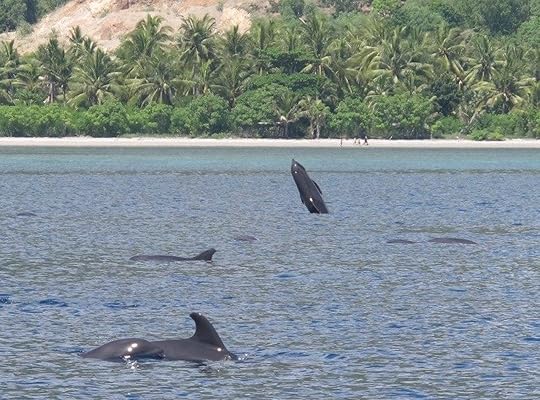
Photo: Atauro Dive Resort/Facebook
The waters around Atauro are clear year round due to the absence of large rivers on the island — which means no sediment runoff into the ocean during the rainy season that runs from December to April. The deep channel between the mainland and Atauro is also home to one of the largest seasonal migrations of whales anywhere on Earth.
The diversity of these whales is similar to that of the reefs. Large populations of blue whales, beaked whales, melon headed whales, short finned pilot whales, and multiple dolphin species migrate between the Indian and Pacific Oceans each year between October and December. Oceanphiles regularly spot these pods, often over 100 whales deep, even just on the routine boat ride over from Dili.
Most important is that you should come soon. To find such a beautiful gem of a place that few people have on their radar is almost unheard of in the internet era. Large-scale development organizations are pouring millions of dollars into tourism projects on the island, making it increasingly easier to reach and explore. Timor-Leste is among the least-visited countries in the world, making for a unique travel experience that you won’t regret seeing before the masses. 

More like this: 5 places to go diving around Palau
The post Atauro Island has the most biodiverse waters in the world, and hardly anyone knows it exists appeared first on Matador Network.


A day in Northern Ireland itinerary

Northern Ireland’s Atlantic northern coastline is one of striking beauty. A land where wild waves crash against craggy headlands, monolithic sea stacks rise above the foamy tides, and meadows and rolling glens give way to tree-lined paths ambling towards rural cottages and farmhouses. Yet while the arresting scenery is par for the course around here, the aesthetics are just the beginning. The coastline is also studded with parochial seaside towns, eateries dishing out superb local cuisine, iconic pubs, and a world-renowned whiskey distillery, all coalescing to inject real life into the area. If you’ve only got a day to spend on Northern Ireland’s north coast, here’s how you can maximize those 24 hours.
Note that for convenience’s sake, a car is the best way to get around. If you like a drink, consider booking a hotel or Airbnb for the night in Portrush town where you’ll begin and end your tour.
Morning

Photo: belfastlough/Shutterstock
Kick-off the day in Portrush, a seaside town built into a mile-long stretch of peninsula called Ramore Head. The town is banked on either side by two vast beaches, namely the East and West Strands. Park your car and take a stroll along the latter of these towards Babushka Kitchen Café, a one-room breakfast and lunch deli that sits on a small outcrop of land jutting into the Atlantic Ocean.
You can soak up views of the seascape from the café floor or from a scattering of outdoor tables provided the weather allows, which is invariably difficult to predict in this part of the world. Order the slightly fancified recreations of the local “Ulster Fry,” which is made of bacon, eggs, sausages, a selection of breads, and sides.
Assuming that you haven’t been immobilized by the breakfast feast, head back to the car and set course for the fabled Giant’s Causeway, just a few miles along the coastal road to the east. The Causeway, Northern Ireland’s one and only World Heritage site, is a formation of hexagonal basalt columns created by a volcanic fissure eruption 60 million years ago.

Photo: Lyd Photography/Shutterstock
Local folklore suggests that the causeway was actually formed when a battle ensued between two giants: Finn MacCool of Ireland and Benandoner of Scotland. MacCool built a causeway across to the Scottish mainland so that the two, presumably incensed, giants could batter each other. Who actually won the gargantuan brawl is still a matter of contention, but from this myth the causeway was named.
In any case, there are some stellar hiking trails here. The main coastal path guides you along the ocean shore and onto the causeway itself. For the best views, make your way up the set of weather-beaten steps etched into the cliff face just beyond the basalt columns. From here, how long you wish to continue hiking is at your own discretion; the trail could take days to cover in its entirety. There are, however, several promontories along the path providing wild vistas of the ancient coastline, with views as far as the most northerly tip of the Irish mainland: Inishowen Peninsula. These can be accessed within an hour or so from the Causeway, including time to stop for essentials or take a breath of fresh air.
Afternoon

Photo: Bushmills Irish Whiskey/Facebook
Once you’ve walked up an appetite, retrace your steps to the entrance of the Giant’s Causeway. There’s an old Victorian schoolhouse of greyish stone, surmounted by a miniature belfry that has been gentrified into a bar and restaurant called The Nook. The menu showcases a “taste of Ulster” through classic dishes made with locally sourced ingredients. The seafood chowder is particularly good, as is the coffee and draft beer selection.
With your lunch settled, drive a couple of miles inland to the town of Bushmills, home of the eponymous Bushmills whiskey distillery, which has been crafting whiskey since 1608. The distillery offers tours for less than $13, which can — and in the case of big groups should — be booked in advance. Of course, if you’re the unlucky one behind the wheel, you may miss out on the indulgence of sampling the distillery’s signature blends, but you can stock up on a bottle or two for a later date.

Photo: VanderWolf Images/Shutterstock
Now it’s time for a slight detour to get your Game of Thrones fix. The Dark Hedges at Stranocum, about a 15-minute drive from Bushmills, have been immortalized as “The Kings Road” in HBO’s hit series.
Located in a rather anonymous stretch of pastoral farmland, the famous procession of over 150 beech trees is immediately recognizable, casting shadows over a long avenue below. Though the trees were planted as an ostentatious entrance to the home of local aristocrats in the late 1700s, they spent much of their life in relative anonymity. In 2019, however, they are one of the top tourist attractions in Northern Ireland.

Photo: Nahlik/Shutterstock
Next, make your way back to Portrush for the evening’s festivities. Taking a direct route north then driving west along the coastal road is your best option. This allows you to catch sight of Dunluce Castle, an ancient ruin sitting on a basaltic outcrop between Portrush and Portballintrae. Approaching the castle from the east, particularly when the sun is setting over its head, provides one of the coastline’s most dramatic views. On seeing it, it will become pretty clear why HBO selected it for the set of House Greyjoy in Game of Thrones.
Evening

Photo: Ramore Restaurants/Facebook
Portrush was the center of the world sporting stage in July when it hosted the 2019 Open Golf Championship at Royal Portrush Golf Club. What endeared the town to so many was not only the fine links setup of the golf course but also the lively drinking and dining scene. Given the festive scene, we highly recommend leaving your car at the hotel before embarking upon the evening’s activities.
The Ramore complex, named after the peninsula on which it’s located, is a hive of activity in the evenings, with a host of homey restaurants and bars by the water’s edge. Spoiled for culinary choice though you may be, a T-bone steak in the Ramore Wine Bar is hard to beat — with all the trimmings and homemade pepper sauce, of course. The rest of the menu is beefed up with local stalwarts, and dishes inspired by continental European and Asian cuisine. Prep yourself for a satisfied, yet marginally distended, stomach; the portions are extremely generous.
After dinner, head next door to the Harbour Bar for a liquid dessert. Located on the ground floor, this iconic pub exudes the warmth and salubrious character you’d expect in a traditional Northern Irish watering hole: cramped, cosy confines; ramshackle furniture; alcohol memorabilia and paintings by local artists covering up the aging paintwork; and a buzzing atmosphere, wall to wall with imbibers and raucous laughter. On the weekends, local musicians and singer-songwriters fill the bar with sounds of Ulster, while a famous face or two may populate the tables. A pint of Guinness in here is a must.
If you fancy something a trifle more urbane, head up to the first-floor gin bar where the environs, dressed in maritime memorabilia and illuminated craft spirit bottles, are somewhat classier. Whichever place you choose, the merriments are likely to continue long into the night.
More like this: The best non-touristy pubs in Dublin to drink at instead of Temple Bar
The post 24 hours on Northern Ireland’s stunning north coast appeared first on Matador Network.

Camping along CA's Highway 1

Driving up California’s Highway 1 is high on many travelers’ bucket lists — with good reason. The drive doesn’t just connect California’s charismatic coastal cities, from San Diego past Santa Barbara all the way to San Francisco, but it also takes you past the stunning scenery of coastal mountains, crashing Paficic Ocean waves, and weathered bluffs. To truly make a great trip extraordinary, though, camp your way up the coast.
Rent a campervan and explore the variety of coastal campgrounds at California’s state parks. Not only will you save money on pricey lodging, but you’ll also go to sleep with the sound of the surf and the scent of salty sea air. You can also do this trip with a regular car, a tent, and other car camping supplies. You’ll enjoy campfires (or do without if there are restrictions), glittering starry nights, and morning walks by the sand dunes. It doesn’t get much better than that.
Below are favorite coastal campgrounds from San Diego northwards to beyond San Francisco. Try to make reservations at these campgrounds ahead of time, particularly if you plan on driving during the peak season summer months. You can reserve the campgrounds at the California state parks and state beaches up to six months in advance. Big Sur’s Kirk Creek Campground is in a national forest and can also be reserved six months ahead, as noted below.
1. San Elijo State Beach — San Diego

Photo: bonandbon/Shutterstock
This popular oceanfront campground is just 40 miles north of San Diego and features 157 campsites on towering bluffs. Look at the map carefully before booking your site, though, as some campsites are closer to the road, and others are closer to the ocean. You’ll enjoy a long, sandy beach and plenty of water sports at this beach park, where the Pacific Ocean waters are slightly warmer than up north. San Elijo is a popular spot for surfers, as well as snorkelers and scuba divers who come to explore the reef. When you need a break from sand and surf, walk across the Pacific Coast Highway to downtown Cardiff, which offers coffee shops, restaurants, and boutiques.
2. Crystal Cove Campground — Orange County

Photo: SunflowerMomma/Shutterstock
After you’ve spent the day exploring the sights and sounds of Los Angeles, you’ll be ready to take it easy at your next beautiful beachside campsite. Next on the list is Crystal Cove State Park’s Moro Campground, perched on a bluff high above the Pacific Ocean. Choose from 58 different campsites, all with extraordinary views. There’s a lot to appreciate about Crystal Cove State Park, including 3.2 miles of Pacific coastline, wooden canyons, open bluffs, and an underwater park offshore for scuba divers. If you want to get down to the water, put on your walking shoes. The beach is a good quarter-mile from the campground, down a hill, and through a tunnel under Highway 1.
3. Point Mugu Beach Park — Malibu

Photo: Andy Konieczny/Shutterstock
Five miles of ocean shoreline with sandy beaches, dunes, rocky cliffs, and river canyons are yours for the taking at Point Mugu Beach Park, just 90 minutes or so north of Los Angeles. This gem of a park offers 70 miles of hiking trails and beach camping at Thornhill Broome beach, which allows you to pitch a tent right on the sand. While you may love falling asleep to the crash of the ocean surf, you’ll also hear cars whizzing by on Highway 1. Nonetheless, this is a lovely, quiet beach and an amazing find so close to the bustling metropolis of LA.
4. Refugio State Beach and El Capitan State Beach — Santa Barbara

Photo: Wayne Via/Shutterstock
Once you near Santa Barbara on Highway 1, you’ll feel like you’ve arrived in the California you see in the movies. Palm trees sway in the warm breeze, and sand feels hot against your feet. Santa Barbara is paradise, with two gorgeous state beach parks with campsites just steps away from the surf. Refugio State Beach and El Capitan State Beach are only three miles apart but have different vibes.
Refugio is a low-key beach with planted palm trees, but El Capitan has a more rugged vibe, with its tall cliffs and long wooden stairs leading down to the shore. Both are right next to exciting activities like surfing, hiking, kayaking, and fishing. Walk down to the beach to explore tidepools or use binoculars to search for dolphins and whales. Or, if you need a break from all the road-tripping, grab a beach chair and a book and enjoy a lazy afternoon as the sun nears the horizon.
5. Los Padres National Forest — Big Sur

Photo: Robert Bohrer/Shutterstock
Highway 1 through Big Sur is one of the most scenic parts of California’s coast. The two-lane highway winds along craggy cliffs with the Santa Lucia mountains on one side and the cerulean Pacific Ocean on the other. Within the Los Padres National Forest, the Kirk Creek Campground offers some of the best oceanside camping in the state, where each site overlooks the sea. From here, take a short trail down to the beach or explore a variety of scenic trails in the national forest. This campground — which you can reserve here — is a little rustic, though, with no running water. Be sure to pick up a couple gallons before setting up camp.
6. Manresa State Beach, Santa Cruz

Photo: Sharonab12/Shutterstock
No visit to California is complete without a stop in Santa Cruz, which blends laid-back hippie culture with Northern California’s rugged beauty. Walk along the iconic boardwalk before exploring the surf museum and grabbing a beer at one of the many breweries. From Manresa State Beach, you’ll enjoy panoramic views of bluff-backed sand and sea, plus the rolling Santa Cruz mountains and forested Monterey Peninsula. Choose between 60 walk-in campsites that are only a short hike from the beach. Since these campsites are walk-in, they aren’t ideal for campervans or RVs, but if you are carrying a tent, you won’t be disappointed by this oceanside campground.
7. Half Moon Bay State Park, Half Moon Bay

Photo: VDB Photos/Shutterstock
If you didn’t have a tent for the campground at Manresa State Beach, no worries. Just an hour north of Santa Cruz, and about 45 minutes south of San Francisco, you’ll find peaceful Half Moon Bay with four miles of broad, sandy beaches and a quaint downtown full of art galleries and restaurants. If you camp at Half Moon Bay State Park, a short access trail leading down to the beach is only 100 yards away. Francis Beach has 52 individual campsites with coin-operated hot showers, a bonus if you’re doing an extended road trip in a campervan. You can gaze right out upon the bright blue sea from this stunning campground, and it’s the perfect spot to watch a popsicle-colored California sunset.
Doran Beach State Park, Bodega Bay

Photo: RedXII/Shutterstock
About 90 minutes north of San Francisco, Doran Beach State Park feels worlds away. Walk down a two-mile stretch of sand and listen to the roaring surf, or meander through grassy dunes on the Bird Walk Coastal Access Trail. This glorious state park — not far from where Alfred Hitchock filmed the horror flick The Birds — features four different campgrounds with 120 campsites. The Shell, Gull, and Cove campgrounds are bordered by Bodega Bay on one side and an access road on the other. The Jetty Campground has Bodega Bay on one side and the beach on the other, so it’s our top pick at Doran Beach State Park.
More like this: Simple ways to fit camping into your crazy busy life
The post Camping your way up California’s Highway 1 appeared first on Matador Network.

Where Greek yogurt comes from

From my apartment in Brooklyn, a search for Greek yogurt available for delivery from Whole Foods comes up with more than 350 results. Some are nonfat, others are flavored with fruit. More than a couple are “Aussie Greek,” and hundreds are organic or Icelandic or from upstate New York, lumped in with the Greek yogurt by an algorithm that treats “Greek yogurt” as a catch-all style rather than a location-dependent product.
And the algorithm is right. Greek yogurt isn’t a location-dependent product. It’s not even really Greek.
What Americans know as Greek yogurt is a yogurt with most of the whey strained out, making it thicker. In Greece, it’s called straggisto (which simply translates to strained yogurt). Fage, a company that started in Athens, Greece, was the first to put “Greek” on yogurt labels as a way to describe the product. However, Chobani, a company started in the United States by a man from Turkey, popularized the practice. (Fage unsuccessfully sued Chobani in the US for, among other things, branding itself as Greek in the 2010s.) All yogurt is Greek in Greece by default, though.
“Places in Greece sell yogurt and don’t need to call it Greek yogurt,” says Matt Barrett, the man behind Athens Guide. “The companies in the USA that sell what they call Greek yogurt are generally not Greek. One or two are Turkish and the rest are a mix of small dairy companies and large corporations.”
Actual Greek yogurt (as in, yogurt made and sold in Greece) can come from cows, sheep, or goats. It can be thick or thin. It is, simply, just as diverse a category as it is everywhere else. Still, when Americans visit Greece, they bring their perceptions of American Greek yogurt with them. Rachel Montague runs four tours through Athens Daily Food Tour and has met around 2,000 Americans through her work. On two of the tours, they serve Greek yogurt.
“This subject comes up on around 50 percent of our tours,” Montague says. “They want to know what makes it so different here than the yogurt they buy in the US and they also want to know why it is so thick.”
The answer is in the process. Greek yogurt is initially made the same way as other yogurt by heating milk and then adding a bacteria culture to kick-start fermentation, turning the liquid into a more solid goop. The next step is what separates the two. Greek yogurt is strained, leaving a thicker end product. Strained yogurt is made around the world, but Fage was the first to popularize it in the US. The company attached “Greek” to the name of its strained yogurt, and with the added publicity of Chobani doing the same, Americans came to associate all strained yogurts as one with “Greek” in the name.
Attaching a location to yogurt is an interesting trend for another reason: Yogurt is one of the most universal foods in the world. The word for yogurt comes from the Turkish word for coagulate or curdle, yoğurmak, according to an article in the journal Nutrition Reviews. Yogurt itself was likely invented independently in different parts of the world. Ayurvedic scripts from India mention a healthy yogurt product dating back to 6,000 BC, and yogurt has been made in Bulgaria since at least 2,000 BC. While it’s hard to be certain, yogurt was probably first invented by people who carried milk in bags made from animal intestines, which had just the right bacterial mix to curdle the milk and turn it into a longer-lasting dairy product.
When it comes to the Greeks, the first mention of yogurt was in 100 BC, the Nutrition Reviews article states, when an ancient Greek writer noted “the use of yogurt by barbarous nations.”
People ate naturally fermented yogurt around the world without knowing exactly how it was made until 1905. That year, a Bulgarian medical student named Stamen Grigorov discovered Lactobacillus bulgaricus, the bacteria that makes yogurt cultures (today, companies also commonly use Streptococcus thermophiles). Yogurt didn’t gain popularity in the US until the mid-1900s when Dannon brought yogurt making to the Bronx, according to NPR.
Regular yogurt walked so the Greek yogurt category could run. Today, yogurt branded as Greek yogurt account for $3.7 billion of the $7.17 billion US yogurt market. It has and likely always will be a large number that’s largely irrelevant for actual Greeks in Greece.
“In Greece, to call it Greek yogurt would be like saying ‘American hamburger’ in the USA or ‘British-style fish and chips’ in England,” Barrett says. Still, it’s not necessarily a negative. “Anything that makes people comfortable about traveling, like knowing they can get a food that they eat every day at home, is helpful.”
More like this: 12 traditional Greek dishes that prove how tasty the Mediterranean diet is
The post No, Greek yogurt isn’t from Greece appeared first on Matador Network.

Best dessert food tours in the US

Restaurants might grab most of your attention when you show up in a new city, but everyone knows that dessert is more important than dinner. There’s always room for dessert, even if you’ve indulged in a hearty meal with appetizers and a hefty entree. The main obstacle is deciding which place to go. Cafes tend to blend together. Pastry shops may appear on every corner, but you don’t want to waste your sweet tooth on a less-than-stellar treat. That’s where dessert tours come to the rescue. Designed to totally eliminate FOMO, these tours will bring you to the best sweet shops in town and let you try a bit of everything. Here are a few of the best dessert walks in the US.
1. Cupcakes and Ice Cream Walk in Chicago

Photo: Sprinkles Cupcakes (Chicago)/Facebook
Chicago’s Magnificent Mile might be named for its abundance of luxury hotels, shops, and trendy restaurants, but cupcakes are a strong addition. This famous street is home to some of Chicago’s most delicious cupcake spots, and on the Cupcakes & Ice Cream Walk, you’ll get to see (and taste) them all. Among many others, some of the best-known stops include Chicago staples like Sprinkles and Molly’s. And once you’ve filled up on cupcakes, you can indulge in second dessert with a healthy helping of ice cream available at multiple stops. To keep the memory alive long after the walk is over, buy take-home treats at Sacred Grounds Bakery along the way.
Tickets to the Cupcakes & Ice Cream Walk are $50 each and can be purchased online. Tours run every Saturday and Sunday from 1:00 PM to 2:30 PM. The American Walks company offers a variety of other food and dessert-themed walks in Chicago, like the Donuts & Sweets Walk.
Cost: $50, purchased online
2. Chocolate Tour in Newburyport, Massachusetts

Photo: Newburyport Chocolate Tour/Facebook
Newburyport, Massachusetts, might seem like a classic New England seacoast town, but when you look under the hood, this town holds a few surprises. One of them is the annual NBPT Chocolate Tour, which is the perfect way to explore this small historic town. Taking place in mid-May, this chocolate tour will take you around Newburyport’s downtown area, which is defined by its cobblestone sidewalks and squares, riverside boardwalk, and seafood restaurants. It’s not a guided tour but rather allows you to explore the town at your own leisure and hit as many of the stops as you like. Yes, you can visit the same place more than once.
The tour includes 30 Newburyport stores — which, given the town’s small size, is pretty much all of them — doling out handmade caramels, chocolate cake, ice cream, chocolate-covered strawberries, and more. A chocolate fountain has even been known to make the occasional appearance.
Cost: $20, purchased at the Unitarian Church on Pleasant Street
3. Hell’s Kitchen Dessert Tour in New York City

Photo: Sugartooth Tours/Facebook
Hell’s Kitchen is known for its many restaurants, and this neighborhood in Manhattan is also home to one of the country’s best dessert walks. Sugartooth tours will not only expose you to tons of samples but also give you some delicious insight into the area’s history. Sweets include artisan handcrafted chocolates, traditional American pies, homemade fudge, frozen custard, and some of the best cookies and Greek pastries you can find in New York City.
The tour accommodates between three and 16 guests, and it begins in Times Square before heading into Hell’s Kitchen. It then progresses to 9th Avenue, where you will also learn about this street’s culinary history.
Private tours are available for groups of six or more, and they can even be personalized to suit your group’s specific taste and needs. Tours run most Saturdays at 1:00 PM though private tours can be requested for other times.
Cost: $55, purchased online
4. Chocolate Tour of Back Bay in Boston

Photo: Cocoa Beantown Tours and Events/Facebook
Boston might be known for its place in American history, but the city’s chocolate history is just as tantalizing. On this chocolate tour of Boston’s Back Bay, you’ll learn all about the history of chocolate as it relates to Boston, all while tasting tons of treats. Each guest will have the opportunity to try chocolate candies prepared at the area’s bake shops, including Max Brenner, L.A. Burdick, and Gourmet Boutique. You will also receive a goodie bag with some additional surprises.
Private chocolate tastings and wine pairing classes are also available for those who are so inclined. The group chocolate tour takes around 2.5 hours and leaves every Saturday at 10:15 AM.
Cost: $50, purchased online
5. Gourmet Chocolate Tour in San Francisco

Photo: Gourmet Walks/Facebook
The fanciest chocolate tour on this list takes place in San Francisco. The city is in the midst of a gourmet chocolate boom, where quality beans, exotic fillings, new production methods, and creative packaging are taking the scene by storm. Even if you’re not a chocolate connoisseur yet, you will be by the end of the Gourmet Chocolate Tour. You’ll learn exactly what sets fine chocolate apart and sample a wide range of local San Francisco chocolates, including unshelled truffles, Swiss Champagne truffles, hazelnut Parisian macarons, and decadent chocolate velvet cupcakes. The tour will also educate you on San Francisco’s chocolate history, taking you through the waterfront area where Ghirardelli first established his famous shop during the Gold Rush.
Guests will each receive a Guest Loyalty Card, which means VIP discounts and benefits at seven different chocolate boutiques. The tour takes between 2.5 and three hours and runs from the waterfront to Union Square. The tour begins at 10:30 AM on Mondays, Wednesdays, and Fridays; at 12:00 PM on Tuesdays and Thursdays; and at 2:00 PM on Saturdays.
Cost: $55, purchased online
More like this: The ultimate European bucket list trip for chocolate lovers
The post The 5 best dessert walking tours in the US appeared first on Matador Network.

Food-based travel on the rise

People travel for more reasons than it’s possible to count. There are tropical paradises and historical sights. Then there are all the different types of food that can be found when traveling. Turns out the latter is becoming one of the biggest motivations for people to fly across the world.
The travel website Kayak recently conducted a survey on behalf of YouGov that found that restaurants are drawing tourists to new places. The study found that 44 percent of Americans would book a flight, travel by train, take a road trip, or go on a bus ride just to dine at a specific restaurant. An additional 30 percent said they’d take a long detour while 42 percent said they’d take a day trip just to visit a restaurant on their bucket list. These travelers are in good company. Another Kayak study done with OpenTable found that 23 percent of diners have flown for food.
If the restaurant is close by, all the better. Sixty-one percent of Americans reported that they’d travel more than an hour for a restaurant with a reputation for delicious food. They’re more adventurous and open-minded too: 62 percent of those surveyed admitted that they’re more interested in trying local cuisine than the familiar dishes they could easily find at home.
And their interest isn’t limited to glamorous five-star, Michelin-approved restaurants. Seventy-three percent of Americans said they’d rather eat at a restaurant favored by the local community than a fancier (and probably more expensive) high-end restaurant.
The growing interest makes sense as shows like Chef’s Table bring international acclaim — and interest from people not necessarily acquainted with the culinary world — to restaurants like Osteria Francescana in Modena and Blue Hill in New York City.
Perhaps even more importantly, food shows hosted by culinary superstars like David Chang, Samin Nosrat, and Anthony Bourdain have showcased cuisines unfamiliar to many Americans, as well as brought more recognition to the chefs who are creating some of the best food in the world at street vendors and stalls. These efforts drive tourism to destinations from Asia to Italy and, even better, promote a deeper and more meaningful cultural understanding between America and the rest of the world.
More like this: French low-cost airline is making flying between New York and Paris super cheap
The post Forty-four percent of travelers say they’d fly, train, or road trip just for a restaurant appeared first on Matador Network.

New Zealand penguin sent home

We know penguins are good swimmers, but this one was in exceptionally good shape. This Fiordland penguin from New Zealand was found washed up on a beach in Victoria, Australia, over 1500 miles away from home.
The Fiordland penguin was discovered emaciated and struggling against rocks at Kennett River, 105 miles west of Melbourne, reported The Guardian. The animal was brought to Melbourne Zoo, and given fluids, nutrients, and later on, food to help it recuperate after its long swim across the Tasman Sea.
Dr. Michael Lynch, the zoo’s head of veterinary services, said, “Once it got going it really stacked on the weight, a huge appetite. It was eating 20-25% of its own bodyweight per day.”
The zoo then sent the penguin to Phillip Island Nature Parks to rehabilitate its swimming muscles, and after eight weeks, it was released this month.
According to Lynch, “We are hoping that it will get back to New Zealand and breed. We put a microchip into the bird so if it does turn up back in New Zealand one day and someone reads that microchip we will be very happy.”
More like this: 7 animals saved at the 11th hour, and why there is hope for the world’s species
The post New Zealand penguin found 1,500 miles from home was released back into the wild appeared first on Matador Network.

New York’s Finger Lakes wineries

For the wine-savvy, upstate New York’s Finger Lakes are synonymous with vineyards. The area’s wine tours have exploded in popularity in recent years, and its wineries rake in accolades and praise year after year. With more than 120 wineries spread through the Finger Lakes region, winemaking has become a pillar of the community, providing a livelihood for some and a must-see destination for everyone else.
These are cool climate wines — only vines hardy enough to survive New York’s harsh winters can thrive here — so winemakers must constantly be ready to adapt to the smallest shifts in climate. Now that climate change is no longer a threat but a reality, the need for action is even more urgent. Finger Lakes winemakers must take creative measures to protect their vines and ensure the longevity of wine in the region.
“Everyone who loves wine should care about climate change,” says Suzanne Hunt, director of strategic development at Hunt Country Vineyards in Branchport, New York.
Hunt and other environmentally conscious winemakers must integrate sustainable solutions to both solve problems winemakers have always faced, like frost that can kill vines, and ensure that their land is viable and healthy for future generations.
“Stewardship of a place has always been part of our DNA,” she continues. “Healthy soil and healthy water are the bedrock of winemaking. If you have clear air and clean water you’re going to have a better product.”
Wineries around the world are responding to climate change in a variety of ways. Sonoma, for instance, recently became one of the most sustainable wine regions in the country thanks to waste reduction, recycling, and land management practices. New York vineyards face a different set of challenges than those out west, however.
Here are some of the ways that winemakers in New York are adapting to — and combating — climate change.
Sustainable insulation to protect against colder winters

Photo: CJS Vineyard
Fluctuations in temperature can be devastating to vineyards. Once winter temperatures reach 32 degrees, winter frost hits, and if the grape vines aren’t properly protected, they freeze, resulting in at least a partial loss of the season’s crop. Thanks to climate change, the Northeast is undeniably getting colder: Recent changes in the jet stream (fast moving air currents in Earth’s atmosphere) have allowed the polar vortex to more frequently escape the Arctic, causing even harsher winters in places like New York and Boston.
“From my perspective, we have seen more cold, cold episodes in the winter,” says Chris Scholomiti, who is a winemaker with his wife Janice at CJS Vineyards in Auburn, New York. “But we’ve had some warm summers. We had a great summer 2012 and 2016. It’s up and down.”
Many vineyards around the Finger Lakes are protected from the harshest winter weather in part by the proximity to Seneca Lake, which acts as a natural temperature stabilizer. Still, extra measures have to be taken to ensure that the vines don’t succumb to winter’s frost.
Most Finger Lakes vineyards grow grafted grapevines — American rootstock grafted to European Vitis vinifera grape varieties — to combat the vine-killing phylloxera pest. The part of the vine where the rootstock and vinifera meet is especially vulnerable to cold weather and needs to be protected.
Typically, vines are covered with soil at the base of the vine to protect from frost, but there are pitfalls to the method, Scholomiti says. One is that it requires driving a tractor between the rows of vines to deposit soil in the fall, and then doing so again in the spring to remove it. Scholomiti decided seven years ago to instead insulate with unused straw recycled from farms near the vineyard. Straw deteriorates as the weather gets warmer, depositing nutrients back into the soil as it does so. The straw also acts as natural weed suppressant. Hunt Country Vineyards also lays straw between rows of vines as an additional weed suppressant, as well as to trap more moisture in the soil, which keeps it healthy.
“Working with Mother Nature has always been a challenge,” says Scholomiti, who has been growing grapes since 1995. And it’s only going to get more complicated.
Scholomiti’s observations that weather has been “up and down” in recent years is an understatement. The Department of Environmental Conservation documented that the annual temperature in New York is actually getting warmer, despite more frequent cold snaps. But that isn’t always good news for vines either.
Scott Osbourne, owner of Fox Run Vineyards in Penn Yan, New York, has been growing grapes since 1994. He says that for his first 14 years, he never had to worry about frost. Then, around 2007, he began to notice uncharacteristically warmer weather in early spring, which in turn warmed up Seneca Lake. That’s when the trouble started.
Typically, when the buds feel cold wind blowing off the lake, they stay shut, delaying bud break until May 15, after the final frost has already passed. However, if Seneca Lake is blowing warmer air up to the vineyard earlier, it “kicks the buds into gear,” as Osbourne puts it, pushing bud break up to early May or even April. Vines that bud prematurely are vulnerable to a late frost that could kill them all off. As a precaution, Osbourne bought a propane-fueled 40-foot-tall wind machine, which funnels warmer air toward the ground, preventing frost from settling around the vines. So far, he’s only had to use it once.
Threats from both warmer and colder weather don’t scare Scholomiti. He’s confident that winemaking will endure in the Finger Lakes. Climate change is complicated but his purpose is simple: “Be friendly with the environment and improve our winemaking.”
Solar power

Photo: David Muyres/Hunt Country Vineyards on Keuka Lake in the Finger Lakes/Facebook
In 1962, after immigrating to the United States from Ukraine with little more than the lint in his pockets, Dr. Konstantin Frank (his PhD is in viticulture) founded his own winery. From day one, Frank wanted his business to be environmentally conscious and sustainable, and he was disturbed by the amount of chemical pesticides American winemakers used on their vines.
The winery has now been in the Frank family for four generations, and general manager Meaghan Frank is carrying on her great-grandfather’s original mission. In 2016, she joined a coalition of three other wineries — Hunt Country, O-Neh-Da, and Eagle Crest Vineyards — in a solar panel initiative to install panels on each respective property. The panels at Dr. Frank’s cover around 50 percent of the winery’s energy needs, and Frank is currently looking into a concept called solar water, which uses the panels to heat water used in the winemaking process.
Hunt Country has 348 solar panels. The winery also installed a geothermal heating and cooling system seven years ago. Combined, these two clean energy sources have nearly eliminated the need for fossil fuels (the tractors still run on gas) on the vineyard and surrounding property. In 2015, the four solar-powered wineries collectively won the Solar Champion Award from the Solar Energy Industries Association for the efforts to transition to solar power.
Fox Run Vineyards runs on close to 100 percent solar power as well. The winery is among a growing group that recognizes that solar power is the future of energy.
“As a farmer, I see that solar power has a minimal impact on the environment, and it is an easy way to reduce my carbon footprint,” says Osbourne. “With my solar installation I pretty much produce enough electricity to supply Fox Run with all its electrical needs. I’m proud of all the Finger Lakes wineries that have installed solar panels for their businesses.”
Both Hunt and Frank feel a responsibility to educate anyone curious about solar energy, and share the benefits of sustainable farming with the public and fellow winemakers.
Hunt has put solar panels on display during winemaker dinners so farmers can test the panels’ durability. All the employees at Hunt Country are trained to tell each and every person that walks through the winery’s doors about its sustainability efforts.
Meanwhile, Frank has noticed that visitors to her winery are eager to learn more about sustainability and solar power — and that they’re using their money to buy products that align with their values. When she comes to the city for events, she says that almost every guest brings up sustainability in the wine industry.
Responsible composting and carbon farming

Photo: Dr. Konstantin Frank Winery/Facebook
Solar power is just one aspect of Dr. Frank’s sustainability efforts. There are some smaller, though no less important, sustainability initiatives at work as well.
“Between the months of September through October when we use our press, we separate the berries from the juice so what’s left is the grape skin and seeds. Some wineries will discard them, but we mix it with manure and spread it back into the vineyards, which helps the soil nutrition,” Frank says.
Hunt Country doesn’t stop there, though. Hunt explains that the certified organic winery is also engaged in carbon farming, a set of farming practices that “result in increased storage of atmospheric carbon in the soil,” according to . Hunt Country, for instance, spreads compost and mulch into the vineyard, where the soil absorbs the carbon trapped inside rather releasing it back into the atmosphere. Carbon farming allows the vineyard to capture hundreds of tons of carbon in its soil each year. That’s one way that “agriculture can be a climate solution,” says Hunt.
Hunt is cautiously optimistic about the future survival of vineyards. Her role as an advocate for environmentally friendly business practices bolsters her hope that the planet can be saved. It also helps to witness the Finger Lakes wine region transform slowly but surely into a leader in sustainable agriculture.
“There are real reasons to be concerned, but the best reaction is to take rapid action, not to simply hope for the best,” Hunt says. “The more people who take action at their own businesses and demand action from political leaders, the more optimistic I become.”
More like this: How Sonoma became America’s most sustainable wine region
The post Climate change is here. Finger Lakes winemakers have a plan to fight it. appeared first on Matador Network.

September 18, 2019
Famous border walls around the world

Border walls are a testament to humans’ obsession with boundaries and our preoccupation to constantly define ourselves against those who exist on the other side. They are among the most important and consequential man made monuments, and understanding them is crucial to understanding the history of human civilization — something as simple as a stretch of raised brick, stone, or concrete can forever impact a region and change how it develops. Many of the world’s most significant border walls still survive today and can be visited. Here are the ones that should be on your list.
1. Great Wall of China

Photo: aphotostory/Shutterstock
The Great Wall of China is probably the world’s most well-known barrier wall, though while marveling at its architectural brilliance, it can be easy to forget that its purpose was strategic. The stone, wood, and earthen wall spans over 13,000 miles from the Gobi Desert to the border of North Korea. Its construction began in the third century BC to defend against the Mongols, but sections continued to be built all the way through the 17th century, when the Ming Dynasty wished to strengthen its position against the steppe nomads to the north. Watchtowers along the length of the wall were used to communicate via smoke and fire signals, and gates were used to manage the flow of trade and migration.
Although it is indeed epic in proportion, and was once the largest man-made object in the world, it wasn’t exactly the most effective defensive barrier. Mongol leader Altan Khan bypassed the wall in 1550 and sacked Beijing, and in 1644, the Manchus broke through the wall, resulting in the fall of the Ming Dynasty.
No longer used as a defensive structure, the Great Wall is now one of the world’s most popular tourist attractions, and arguably China’s most famous structure.
2. West Bank Wall

Photo: Hans Verburg/Shutterstock
A far more modern example of a border wall, though built for exactly the same purpose, is the West Bank Wall built by Israel in 2002. The goal of the 435-mile concrete wall was to protect Israel from Palestinian suicide bombers, and though there had been a decline in the number of attacks since the wall was built, it has nevertheless generated much controversy.
Many believe the wall is not directly responsible for the reduction in attacks but rather political and military moves by the Israeli government combined with Hamas’ discontinuation of suicide bombings. As it completely cuts off the West Bank from other Palestinian areas, some have also called it a human rights violation, as well as an attempt by Israel to secure Palestinian land.
While Israelis consider the wall a defensive necessity against terrorist attacks, Palestinians believe it is a means of racial segregation and refer to it as the “Berlin Wall.” Perhaps more than any other wall that stands today, the West Bank Wall shows how a single structure can be viewed completely differently by two opposing sides.
3. Sumerian Amorite Wall
The Sumerians, one of the world’s earliest known civilizations, were building walls all the way back in the 21st century BC. To keep out the rival Amorites — nomadic tribes people who had been making unwanted forays into Mesopotamia — Sumerian rulers Shulgi and Shu-Shin constructed a fortified barrier. It stretched over 100 miles in what is now Iraq, between the Tigris and Euphrates Rivers, and is believed to be the first extensive defensive barrier not built around a city.
It was first was quite successful in keeping the Sumerians’ enemies at bay, but it was soon overrun (or simply circumvented), after which Sumeria was under attack from multiple forces. Around the year 2000 BC, the capital of Ur fell, and Sumerian culture all but disappeared, though sections of the wall still remain.
4. Hadrian’s Wall

Photo: Michael Conrad/Shutterstock
One of the oldest border walls ever constructed, Hadrian’s Wall spans 73 miles and was built on the orders of Emperor Hadrian in 122 AD. Hadrian built the wall from the Solway Firth on the west coast of England to the mouth of the River Tyne in the east, and wanted a solid border to protect Roman Britain from the Picts and other hostile hostile tribes in Northern England and Scotland. Ten-feet wide and 15-feet tall, the length of the wall is dotted by forts with gates one mile apart to allow soldiers to control movement in and out of the area. The wall was mainly used to protect against raids from the north, as well as to collect taxes.
Hadrian’s Wall remained a towering and effective structure until Rome’s withdrawal from Britain in the fifth century. What followed was 1,600 years of decay, made even worse by frequent looting for building materials. Now the wall is a shadow of its former self, both in size and integrity, but there are still several sections you can visit throughout northern England. Located in Northumberland, Housesteads Roman Fort is perhaps the best-preserved portion of the wall. It’s popular for both quick visits, as well as day-long hikes along the length of the remaining ruins.
5. Great Wall of Gorgan
Not quite as famous as the Great Wall of China, the Great Wall of Gorgan is nothing to sneeze at. Extending for 121 miles, from the southern edge of the Caspian Sea to the Elburz Mountains in modern-day Iran, the barrier was built by the Sasanian Persias around the fifth century. It also included over 30 forts, a garrison of 30,000 troops, and a series of canals that acted as a water supply system, as well as a defensive moat. At the time, it was one of the longest walls ever built and still remains the longest fort-lined ancient barrier between Central Europe and China.
Despite its enormity, however, relatively little is known about the wall’s history. Originally it was called “Alexander’s Barrier” as many believed that it was built by Alexander the Great. More recent research has suggested that the Persians used it to guard against the Hephthalite and other northern enemies.
You can still visit the wall’s remains near the modern town of Gorgan in northeastern Iran.
6. The Berlin Wall

Photo: turtix/Shutterstock
Perhaps modern history’s most famous border wall, the Berlin Wall recalls troubling memories for many who lived during the period when it was standing. Erected in 1961 after the fallout of World War II, the wall was built by the Soviet East German government, who claimed its purpose was to keep out fascists and enemies of the state. In reality, it was constructed to prevent East Germans from fleeing to the West and to keep them from learning about the vast disparity in quality of life that existed between East and West Berlin.
The wall was a maze of guard towers and electric fences, and many people were killed trying to escape. By the time it was eventually torn down in 1989, thousands had successfully escaped to the other side by scaling the wall, tunneling underneath, or even flying over it in homemade hot air balloons.
The wall’s eventual destruction was one of the most symbolic events of the Cold War. The collapse of the Berlin Wall is one of the most enduring images in European history.
Parts of the wall still remain throughout Berlin, often covered in graffiti advocating for peace and acceptance.
7. Belfast Peace Walls

Photo: VanderWolf Images/Shutterstock
The Belfast Peace Walls were built to divide neighbor from neighbor. In this case, the division takes place on religious grounds, with the intent of separating Catholic and Protestant neighborhoods. Erected in the midst of Northern Ireland’s Troubles in 1969, the wall was a physical representation of the political conflict raging all over the country.
Around 100 walls and other barriers were built in total, with the purported aim of “keeping the peace.” Although these Peace Walls were meant to negate conflict, they ultimately created a hostile environment detrimental to communities all around Belfast. Despite their relative failure, the walls remained in place for decades, and it wasn’t until 2013 that the Northern Ireland government promised to begin removing all the walls.
You can still see the Peace Walls around Belfast, but you’d better get there quickly. The first wall was torn down in 2016, and the government plans to have them all destroyed by 2023. Although less dramatic than the fall of the Berlin Wall, the tearing down of the Peace Walls similarly represents improved relations and an important step toward peace.
More like this: 6 places where you can be in two countries at once
The post 7 border walls that shaped the world as we know it appeared first on Matador Network.

Soccer stadium turned into forest

This Austrian soccer stadium is assuming a pretty unique aesthetic that has nothing much to do with sports. The Wörthersee Stadium in Klagenfurt has been covered with over 300 adult birch, willow, maple, and oak trees for artist Klaus Littmann’s “For Forest” installation.

Photo: For Forest/Facebook
The largest public installation ever to take place in Austria, “For Forest” is meant to change with the time of day and give visitors and ever-evolving experience, especially with the change of colors that comes with fall. “From 10 AM until 10 PM daily,” the official description reads, “audiences will experience a unique panorama of trees, day and night, under natural light or by floodlight.”

Photo: For Forest/Facebook
The goal of the unique installation is to encourage people to think about forests, and how we can better preserve and care for them. The installation’s official press release says that it “aims to challenge our perception of nature and questions its future. It seeks to become a memorial, reminding us that nature, which we so often take for granted, may someday only be found in specially designated spaces.”
Photo: For Forest/Facebook
The installation has been open to the public since September 8 and will remain open until October 27, when it will be replanted in a public space outside the building. Admission is free.
More like this: The best places in America to try forest bathing
The post This Austrian soccer stadium has been converted into a giant forest appeared first on Matador Network.

Matador Network's Blog

- Matador Network's profile
- 6 followers

