Sam Gennawey's Blog, page 3
September 30, 2013
Palm Beach
 With New York but a memory, Walt traveled on to explore other possibilities. It took little time for another player to enter the picture—in the form of billionaire John D. MacArthur—and the Disney–NBC–RCA deal to build an East Coast Disneyland began to rise like the phoenix. More importantly, the project requirements demanded that Walt and his team create something that would not be a sequel to Anaheim. He would get a chance to solve the property adjacency issues that plagued Disneyland, because he would control what happened on the border. To accomplish this, Walt would become a city builder and surround his park with a new, futuristic community—a town of his own design that reflected his standards. Let’s travel along with Walt to see what actually happened.In 1959, MacArthur decided he wanted to develop five to six thousand acres he owned north of Palm Beach for “a recreational enterprise.” MacArthur had made his fortune as head of Banker ’s Life Insurance and RCA. The Palm Beach project would have been a four-way deal among Disney, NBC, RCA, and MacArthur.Buzz Price was tasked to study the project. From Price’s recollections, we can see that Walt was clearly pursuing his dream to build a community. “We put our effort together with WED in determining what kind of an interrelated park and city could be developed on that site. Walt wanted to emphasize future development in urban living. The park would take up 400 acres. A town base of 70,000 people would take up the rest.” The ERA study looked to incorporate “advanced concepts of architectural design and technological improvements…in all phases of the town development.” For this project, Walt first used the name EPCOT (Experimental Prototype Community of Tomorrow).The project was to include an East Coast Disneyland, and the theme park would be part of a planned community. According to Price, the Palm Beach project represented the moment that Walt got fully obsessed by the idea of building a city. Walt saw an opportunity to do something truly grand; to take advantage of this golden opportunity, he began to learn more about urban planning.
Read more: Walt and the Promise of Progress City
Published on September 30, 2013 04:00
September 27, 2013
The Grove: Disneyland in the Fairfax District
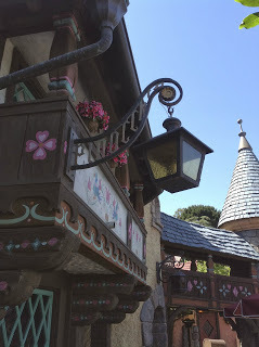 The architectural vocabulary developed at Disneyland has influenced other “invented” places. For an outstanding example, one has only to exit Disneyland and drive north along the freeway to The Grove in the Fairfax District of Los Angeles. Built in 2002, the Grove is one of the most successful shopping centers in the region. It was built adjacent to the historic and world- famous Farmer ’s Market (built in 1934) and was developed by Rick Caruso. Caruso learned many lessons from Main Street, U.S.A. and creatively applied them, resulting in a dynamic urban space. Both Disneyland and The Grove are promenades between two activity nodes. Each has a mid-block street breaking down the scale of the corridor. Both of these “streets” have similar dimensional metrics: the linear distance and the roadway from curb to curb. The Grove main corridor has the same dimensions from the center intersection to the center of the hub park near the musical fountain. Like Disneyland, The Grove mall also features building façades framing a narrow corridor using forced perspective. However, there is a difference: at The Grove, the first floor is standard height for a retail establishment and the upper floor is taller than normal. The result is a highly energized space, not as laid back as Disneyland’s Main Street.Developer Rick Caruso considers Walt Disney a hero and said that he is “one of the true geniuses in the world.” The Grove is what the Los Angeles Times described as a “wildly popular amusement park-like shopping center.” He had already built other “lifestyle” centers in suburban locations such as The Commons at Calabasas and The Lakes at Thousand Oaks. The Grove was his first urban infill project of this type.
Read more: Walt and the Promise of Progress City
Published on September 27, 2013 04:00
September 25, 2013
A Pattern Language
 When we have experienced a space that has a higher degree of life, how can we explain why we feel that way to others? How do we express the positive qualities in such a way that they can easily be shared? In A Pattern Language: Towns, Buildings, Construction, published in 1977, Alexander (withco-authors Sara Ishikawa and Murray Silverstein) suggested a system of fundamental building blocks that can be combined to create wonderful spaces that “make people feel alive and human.” This system consists of 253 patterns that lead to rooms, streets, and districts that work. Each pattern consistsof a specificproblem that occurs over and over again in our environment.The pattern provides “the core of the solution” and is described so that “you can use this solution a million times over, without ever doing it the same way twice.” Thepatterns are numbered andarranged within a hierarchy that stretches from a macro lookat large regions down to a micro look at the proper placementfor climbing plants.Each pattern isscored by importance with up to two asterisks. There are approximately one-third ofthe patterns marked with two asterisks. Two asterisks suggest the connection between place and experience is an “invariant.” Those patterns are a “deep and inescapable property ofa well-formed environment.” Patterns marked with one asterisk are valid but subject tomore research. Patterns that are unmarked are based on empirical data.When used properly, the patterns can be used like an alphabet; various combinations provide the abilityto tell an infinite variety of stories. As outlined in A Pattern Language, the combination of patterns can provide an infinite array of solutions for environmental design.What do I mean by combining patterns? Let me use this example. When preparing a gourmet meal, you must combine theingredients just right. Addingtoo much of the wrong thingor mixing the ingredients improperlywill spoil the result. When you get it right, the result is something that is greater than the sum of its parts. That is when you have achieved ahigher degree of life. The urban plannerand architect want to achieve the same result with the built environment that a great chefachieves with the meal.
Alexander ’s book teaches us how to discern or create clarifying patterns within complex mixtures. Pattern recognition isa crucial skill for an architect or urban plannerwho must create a highly ordered environment amid many competing and frequently nebulous design considerations.
Read more: Walt and the Promise of Progress City
Published on September 25, 2013 04:00
September 23, 2013
The Three Levels of Knowledge
 Creating great places may seem like an impossible task and one left to chance. It is not. We operate with three levels of knowing. The first is simplicity, whichis the worldview of a child or uninformed adult. These people are fully engaged intheir own experience and are happily unaware of what lies beneath the surface of immediate reality.The second level is complexity. This is generally how most adults view the world. These people are aware of the complex systems in nature and society but cannot identify clarifying patterns and connections.The third and highest level of knowing is informed simplicity. This is an enlightened view of reality and is founded upon an ability to discern or create clarifying patterns and connections. According to Christopher Alexander, places that demonstrate a higher degree of life can be achieved by the proper application of sharable positive design patterns; the abilityto do so is a strength ofinformed simplicity.
Read more: Walt and the Promise of Progress City
Published on September 23, 2013 22:07
September 4, 2013
THE EVOLUTION OF INDUSTRIAL AND MIXED USE IN DOWNTOWN LOS ANGELES: CONFLICT OR MUTUAL ACCOMMODATION?

COLLOQUIUM IX: “THE EVOLUTION OF INDUSTRIAL AND MIXED USE IN DOWNTOWN LOS ANGELES: CONFLICT OR MUTUAL ACCOMMODATION?”
Presented by the Los Angeles Region Planning History Group
Saturday, October 5, 2013Continental Breakfast and Registration: 9:00-9:30 a.m. Colloquium: 9:30 a.m. – 2:00 p.m., including guided walking tour
Event is $50.00 and $35 for studentsLocation: Southern California Institute of Architecture (SCI-Arc)350 Merrick Street (between Alameda and Santa Fe, just north of E.4thSt.); free parking provided in lot adjacent
Description: Although Los Angeles is associated internationally with glitz and glamour, it has always been a working city, with a rich industrial heritage. Even today, Los Angeles County is the largest manufacturing center in the United States, accounting for over 365,000 jobs in 2012. But many industrial properties are in transition, with recent market pressures for residential development and dramatic changes in the workplace creating new demand for flexible industrial space and green technology. All of these changes are most visible on the ground in downtown Los Angeles, in the Arts District community and adjacent industrial lands along the Los Angeles River. Join us for a look at Los Angeles’ industrial legacy and future planning policies for industrial land, as seen close-up, through the prism of one of the city’s most fascinating and rapidly-changing neighborhoods. The colloquium will include a presentation on Downtown’s industrial heritage, a walking tour of the Arts District, and a lively panel discussion on present and future policy challenges. Ken Bernstein, Principal City Planner for Policy Planning and Historic Resources, Los Angeles Department of City Planning, will moderate the panel.
Panelists and Tour Guides to Include:
Greg Fischer, historian and principal of LA1781, Inc. a real estate research consulting firm, and former Planning/Transportation Deputy, Councilmember Jan PerryAlan Bell, Deputy Director of Planning, City of Los Angeles, overseeing policies for industrial land and preparation of Los Angeles’ new zoning codeYuval Bar-Zemer, Principal, Linear City Development, developers of transformative projects in the Arts District Donald Spivack, former Deputy Administrator and Deputy Chief of Operations for the Community Redevelopment Agency of Los Angeles (CRA/LA), where he oversaw policy for key downtown industrial lands
RESERVATIONS
Event Fee is $50; for students with valid student IDs, $35 Fee includes Continental Breakfast and Lunch
Seating is limited to 110 attendees; please confirm your attendance to: Alice Lepis, Secretary alepis@prodigy.net (preferred) or at 818.769.4179 on or before Noon, Wednesday, October 2, 2013
You may pay either of two ways:
1. Pay Pal which is accessible through the LARPHG website: LARPHG.org
(or)
2. Check payable to: “Los Angeles Region Planning History Group”with completed registration form sent to:
Los Angeles Region Planning History GroupC/o Alice Lepis, Secretary11227 Acama StreetNorth Hollywood, CA 91602
Please include a copy of your student ID if you are registering as a student.
PLEASE PRINT CLEARLY: FIRST NAME LAST NAME ORGANIZATION E-MAILADDRESS CHECK IF STUDENT
Published on September 04, 2013 14:00
August 12, 2013
REGRETTABLE: WDW MAPS
As an urban planner, I have always been fascinated by maps. You can tell so many stories with one. A good map can guide the guest through unfamiliar surroundings using representations of iconic landmarks. The best seem to also understand the guests point of view.
Recently, WDW updated their maps so that they look like the ones found on the internet. This means they have placed North at the top. Now in a typical map this is just fine. For the Magic Kingdom and Disney's Animal Kingdom, this is no big deal. That is how the park’s are organized. The story for the other parks is a different matter completely.
The Epcot map places the entrance and Spaceship Earth at the top. The map does not tell you where to go. It tells you where you have been. I watched as guests turned their maps upside down so it made sense. The Epcot map actually is somewhat close to scale when it comes to the attractions to the land mass. The result is a rather sparse map suggesting there is a lot of open space between the pavilions of the World Showcase. I don’t think this is what Disney intended.
For Disney's Hollywood Studios, a goofy place to begin with (no pun intended), the map makes no sense. If you ever felt the park's layout was just an afterthought, the map will only reinforce the feeling. In some ways, you can make out the giant hidden Mickey however in this version he is sporting a cone shaped nose much like Jack of Jack in the Box. This is a case of where the maps were not broken and did not need to be fixed.
Published on August 12, 2013 06:00
August 8, 2013
The 1976 Vision for Downtown Disney
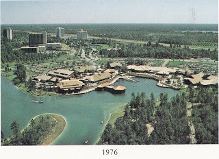
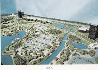
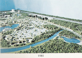 A fairy tale.
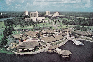
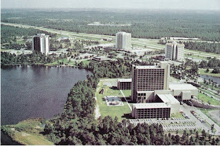
Once upon a time the planners at Walt Disney World really did want to follow Walt’s vision and create a place that would show off on how proper urban design can create places that are greater than the sum of its parts. Disney was in a unique position to make this dream a reality due to the way the property is governed.
In June 1976, the planning department for the City of Lake Buena Vista prepared a report that looked at the addition of a mixed use development to compliment the Magic Kingdom and the resort hotels. Lake Buena Vista is one of two cities that make up the Reedy Creek Improvement District. The Reedy Creek Improvement District was chartered by the Florida Legislature on May 12, 1967. The land use powers given to Disney were unprecedented. In the charter, Lake Buena Vista was planned to be a “new town.”
At the time it was estimated that the population would jump from 344,000 people in 1970 to 541,000 people in 1980 and 750,000 in 1990. In reality, the estimate were off considerably. By 1980, the region was home to 804,925 people and and exploded to 1,224,852 by 1990. This growth was due to the shift in Florida tourism from Miami to Central Florida. Walt Disney World was the must-do destination but it was supported by the Kennedy Space Center, Cypress Gardens, Circus World, Sea World, and other attractions. In total, more than 18 million visitors were coming to Central Florida by 1975.
They saw opportunity in this growth and wanted to shift the center of Central Florida from Orlando to Walt Disney World, namely Lake Buena Vista. In a sense, they were not competing with other theme parks. They were competing with the City of Orlando. They had 4,000 acres to play with and the goal was to serve not only the tourists but the local population.
Location is everything and the new district would be right at the heart of the region’s transportation network. The development was at the crossroads of Interstate 4 and the Florida Turnpike. The only way east-west and the primary way north-south. Not bad. Working through the Orlando Urban Area Transportation Study Technical and Policy Committees in May 1976, Disney made sure they were able to place Lake Buena Vista right at the center of long term transportation planning. Lake Buena Vista would become a major hub in a regional network unlike Downtown Disney’s relatively isolated posture.
The project called for a variety of land uses including “an activity-oriented transient home community,” a unifying transportation system, and distinctive architecture that could be repurposed as needs change. The project would place the most intensive uses at Lake Buena Vista’s borders, adjacent to the surrounding community.
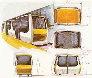
The most innovative part of the plan was the transportation network. At the center of the development would have been a demonstration multi-modal terminal (monorail, taxis, buses, automobiles, electric cars, and pedestrians) that would be connected to the Peoplemover network. This development would represent the “urban” district and consist of parking structures, large scale shopping, and high density hotels and offices.
Along Interstate 4 would be a office park with shopping and dining built around plazas, fountains, and lakes. This would be the “suburban” district. This part of the project would be highly visible and would be designed as a statement for the “environmental” community. This new development was expected to create as many as 9,000 permanent jobs.
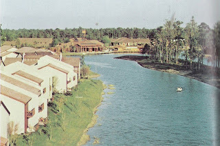
Shops with one of a kind items, craftspeople at work, and outdoor cafes would combine to create the “Village” environment that would dominate another part of Lake Buena Vista. The 32 shops built in 1972 along Village Lake, along with the four existing hotels (Travelodge, the Royal Plaza, the Dutch Inn, and Howard Johnson’s) would be enhanced, expanded, and connected to the office park and multi-modal terminal by new pathways and the Peoplemover.
According to the plan, the long term vision for the project would “perpetuate an image of vitality and excitement and expand upon it to yield a progressive city with coordinated growth.” Instead of relying on a fleet of diesel buses, WDW planners wanted to create a compact, sustainable city that put public transportation as the preferred method of travel. As stated, “The goal being elimination of the car for internal city travel.” Visitors could still get around by automobile but in Lake Buena Vista they would also have the option to walk, bicycle, take a horse or drive an electric vehicle. The pathways for those modes would be separated from auto traffic. Guests could also travel on a network of canals and lakes.
However, the most popular way to travel would probably be the WEDway Peoplemover. With an elevated beamway and virtually no headways, the Peoplemover would have stations at all of the important destinations within Lake Buena Vista. Disney considered the transportation system as a “horizontal elevator.” Unlike the Peoplemover systems at Disneyland (1967) and Florida (1975), this would be a much more sophisticated transportation system. Visitors would press a button and their fully enclosed, air-conditioned car would arrive. They select their destination, press a button, and the car will speed directly there without stopping at intervening stations. A barn with extra cars would be a the ready when demand calls. The system would be able to carry as many as 14,000 passengers a day. One of greatest benefits of the technology is the ability to increase capacity just by adding more vehicles. No new tracks would have to be built or need to acquire new right-of-way. Demonstrating the viability of the Peoplemover via real world experience was one of the primary motivations for the entire project. For those who want to visit the Magic Kingdom they would just board the Monorail.
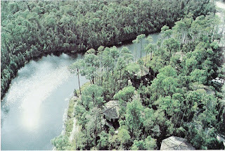
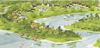
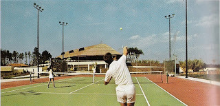
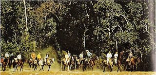
Although the idea of people living permanently within Walt Disney World had been shelved by this time, the project would still focus on creating neighborhoods. These “communities” would attract visitors who share a particular interest. For example, a neighborhood would be based around golf, equestrian, boating or tennis. Within each neighborhood would be a community center. The golf-oriented Treehouse Villas was the first example of this program. Most of the land dedicated to these neighborhoods remains vacant today. The goal was to build as many as 9,000 living units capable of housing 30,000 people. The design of Lake Buena Vista was to create a city within a park and to let the natural landscape dominate whenever possible.
For those interested in tennis, that neighborhood would have tennis courts integrated throughout the village. The rustic Western themed equestrian community would take advantage of the Tri-Circle-D Ranch and feature horse trails and horse carriages as the primary way to get around. The farthest northern neighborhood, sandwiched between South Lake and Lake Mabel, would be the aquatics community. Here, visitors will be able to enjoy lakefront accommodations and plenty of water based recreational opportunities. This land is also currently vacant.
It was the Disney planners goal to create a city center where people could “live,” work, and play that had the critical mass for success and a place where guests and locals would get a taste of the “Lake Buena Vista experience.”
Published on August 08, 2013 21:47
August 5, 2013
EXCEPTIONAL: THE PIRATE ADVENTURE GAME
Got to hand it to the folks at Disney. Instead of building new, expensive, high-capacity immersive rides to give their guests something to do and to get out of aisles, now they have come up with games using the already existing (therefore, paid for) environments. There have been a number of games introduced at the Magic Kingdom. I am not fond of the Sorcerers of the Magic Kingdom game. I understand the draw to collect cards but standing in front of a television as my other reward just wasn’t enough motivation. Kim Possible/Agent P at Epcot is a lot of fun but the chirping little cell phone becomes annoying after awhile. Plus, if you are fan of Breaking Bad, those type of cellphones have a whole new meaning. However, I am fond of the new Pirate Adventure Game.
You start by enlisting at a the HQ right at the western edge of Adventureland. Scan your ticket and the computer will assign you one of five quests, Guardian’s Curse, The King’s Ransom, Blackbeard, Heads You Lose, and Haven Defense. Which quest you start with depends on the computer rationing out the experience. You first challenge is to look at the map and find the icon somewhere in Adventureland that matches your instructions from the computer.
To find the icons, you must grab one of the beautifully illustrated maps. I love these maps. They are printed on thick paper with the edges serrated and ragged just like an old time pirate map. The artwork is outstanding and each map highlight different parts of Adventureland listing only a few of the many game stations. The maps are a terrific prize and grab them while you can before the inevitable start to squeeze out the quality to reduce the cost of production.
Walk out into Adventureland, look at your map, grab your bearings, and find that icon. There is a drawing of the area where the icon is located. Maybe confusing at first but you get the hang of it very quickly. Once you have found the icon, tap your ticket and something marvelous and magical will happen. But be watchful. Your next clue will appear somewhere and if you get distracted you may miss out. The maps show more destinations than you will visit on that particular journey so be careful. Follow the clue to the next station, tap your card, and wait again. Follow the instructions and you are good to go. Pretty simple. Once you have found three or four stations you will be directed back to HQ for another challenge.
The game works for me because it meets one of my primary tests; Quality, Variety, and Surprise. As I stated before, the maps are wonderful and the destinations are well themed and add to the area ambiance. Better still, unless you are playing the game you might not notice them. Brilliant. Like the Epcot game, It is fun to set off a physical gag. Plus, sometimes the gags were so funny I caught myself laughing out loud. What more can you ask?
Published on August 05, 2013 06:00
August 2, 2013
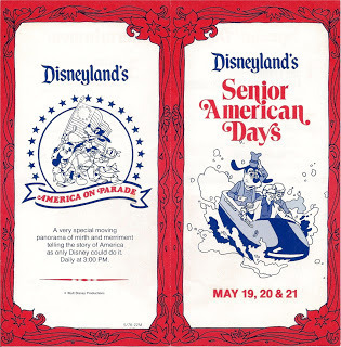
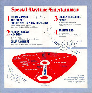
Remember Senior Days at Disneyland?
Published on August 02, 2013 06:00
August 1, 2013
REGRETTABLE: CAROUSEL OF PROGRESS
The oldest attraction at WDW is the Carousel of Progress. Maybe more than any other attraction, this was Walt's project from beginning to end and it represents everything the man was about. He liked to tell stories. He was optimistic about the future and how American technology could solve any problems. The show could inform as well as educate. It really is Walt Disney's Carousel of Progress, his pride and joy.
At what point does Disney become embarrassed? The ride is in awful shape. Lighting is bad, the scrims are dirty, and the Audio-Animatronics are not in the best of condition. The final scene, a look into the near future is completely outdated. Because the park shows so little respect for the attraction, the audience seems to do the same. Throughout the show, people are pulling out their cell phones, not just to check for messages but even having conversations. People are constantly trying to leave, usually as the turntable is moving. The last couple of times I visited the attraction, people decided to leave the moving building early and would trigger the door's emergency stop.
The show's 50th anniversary is coming up in 1964. Wouldn't it be nice if Disney could show a little bit of tender love for this very special attraction?
Published on August 01, 2013 06:00

