Tim Havenith's Blog, page 3
March 20, 2025
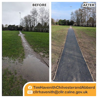
𝐀𝐦𝐛𝐞𝐫𝐥𝐞𝐲 𝐂𝐥𝐨𝐬𝐞 / 𝐍𝐨𝐫𝐭𝐡 𝐄𝐧𝐝 𝐏𝐥𝐚𝐲 𝐀𝐫ǔ
February 28, 2025
Place names of Calne: School Road
February 5, 2025
Calne Community Neighbourhood Plan: 𝐏𝐫𝐨𝐩𝐨𝐬𝐞𝐝 𝐋𝐨𝐜𝐚𝐥 𝐆𝐫𝐞𝐞𝐧 𝐒𝐩𝐚𝐜𝐞𝐬
Calne Community Neighbourhood Plan 2 (CCNP2) looks ahead to 2038 and seeks to protect 27 green spaces within the plan area.
This is in addition to the 14 green spaces protected in the first CCNP.
Let’s have a look at the proposed spaces...
LGS 2.2 Horsebrook Nature Trail, Calne
LGS 2.3 Wessington Park Play Area, Calne
LGS 2.4 Newbury Ave/Honeysuckle Close, Calne
LGS 2.5 Lansdowne Square, Calne
LGS 2.6 Calne Promenade, Calne
LGS 2.7 Holy Trinity Churchyard, Calne
LGS 2.8 Salmons Leap, Calne
LGS 2.9 Jubilee Copse Field, Calstone
LGS 2.10 Fynamore Gardens, Calne
LGS 2.11 West End of Station Road, Calne
LGS 2.12 Magnolia Rise, Calne
LGS 2.13 Lavender Drive, Calne
LGS 2.14 Marden Farm Allotments, Calne
LGS 2.15 Town Gardens, Calne
LGS 2.16 Castlefields Country Park, Calne
LGS 2.17 Woodland Copse, Derry Hill
LGS 2.19 Bremhill View, Calne
LGS 2.20 Lickhill Road, Calne
LGS 2.21 Newcroft Allotments, Calne
LGS 2.22 Bentley Woods & Quemerford Lodge Plantation, Calne
LGS 2.23 The Abberd Brook, Calne
LGS 2.24 Tench Road Mini Woods, Calne
LGS 2.25 Beversbrook Allotments, Calne
LGS 2.26 Woodsage Way, Calne
LGS 2.27 North End Play Area, Calne
LGS 2.28 Theobalds Green, Calstone
Note: LGS 2.18 (Pocket Park) was proposed for designation but did not pass examination tests and therefore is not included in this Plan.
Head to the Calne Community Neighbourhood Plan website for more information.
January 31, 2025
Place Names of Calne: Buckeridge's Steps
 Buckeridge's StepsBetween 1876 and 1988, three generations of the Buckeridge family ran a shop that began as a grocer's and wine and spirit merchants business, at the corner of Market Hill.
 Kelly's Directory, 1915The business started with Albert Wilkinson Buckeridge (1838-1923). After the First World War, his son, Launcelot John (1886-1977), took over the business. Following the Second World War, Launcelot's sons, David, Paul, and Ted went into partnership, running the business until they sold the business upon retirement in 1988.
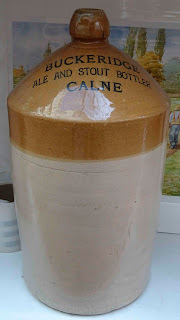 This was a successful business, which had a bottling plant and warehouse at the back of the shop and up in Castle Street. All beers and wine would arrive in large containers, to be transferred to smaller bottles and labelled. This included Guinness, with the Buckeridge's being one of the few licensed to bottle this drink under their own name. Along with supplying the local clubs and pubs with drinks, they were also known for their cheeses.
Cheese is something they decided to specialise in, along with wine and beer, when the supermarkets began to appear in the 1960s.
After 1988, the shop became Unwins, followed by the New Wine Shop. Unfortunately the shop was left empty in 2019, and we await a new occupant in this prominent shop.
For 112 years, this family business, at a prominent location, was an important part of Calne's history. In addition to the shop, they had a . So, it seems only right that these steps are known for the family that would have used this route so often.
References:
Information from Calne Heritage Centre
Place Names of Calne: White Horse Way
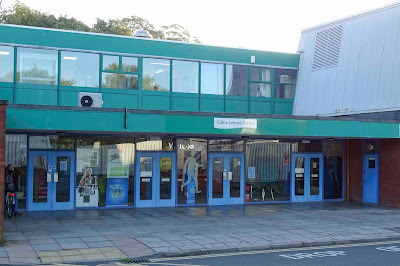 Calne Leisure Centre, 2019.White Horse Way leads to the Calne Leisure Centre (during the 1990s, called White Horse Leisure Centre), which was opened in 1976, upgraded in 1997-98, and is being turned into Calne Community Campus during 2019/2020 thanks to a £3 million investment by Wiltshire Council. The road also provides access for Kingsbury Green Academy.
January 20, 2025
𝗛𝗔𝗩𝗘 𝗬𝗢𝗨𝗥 𝗦𝗔𝗬 - 𝗨𝗦𝗘 𝗬𝗢𝗨𝗥 𝗩𝗢𝗧𝗘 ☑

1. The poll will take place on Thursday 27 February 2025.2. Applications to register to vote must reach the Electoral Registration Officer by 12 midnight on Tuesday 11 February 2025. Applications can be made online at www.gov.uk/register-to-vote.3. Applications for postal and postal proxy votes must reach the Electoral Registration Officer at Electoral Services, Wiltshire Council, County Hall, Bythesea Road, Trowbridge, Wiltshire, BA14 8JN by 5pm on Wednesday 12 February 2025. Applications can be made online at www.gov.uk/apply-postal-vote.4. Amendments or cancellations to existing postal, postal proxy and proxy votes must reach the Electoral Registration Officer by 5pm on Wednesday 12 February 2025.5. Applications for a Voter Authority Certificate or an Anonymous Elector's Document valid for this election must reach the Electoral Registration Officer by 5pm on Wednesday 19 February 2025. Applications can be made online at www.gov.uk/apply-for-photo-id-voter-authority-certificate.6. Applications to vote by proxy must reach the Electoral Registration Officer by 5pm on Wednesday 19 February 2025. Applications can be made online at www.gov.uk/apply-proxy-vote.7. A person can apply to vote by 'emergency' proxy if they learn they cannot go to the polling station because of their occupation, service or employment, or a medical condition, illness or disability arises, after 5pm on Wednesday 19 February 2025. Applications must reach the Electoral Registration Officer by 5pm on Thursday 27 February 2025.8. Full details of upcoming polls including timetables, forms to register to vote and results can be found by scanning the code.


For more information, please visit:
https://www.calnecommunityplan.com/
January 17, 2025
Two Recent MyWilts Reports
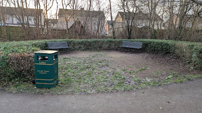
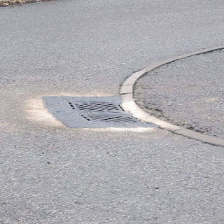
I greatly appreciate the efforts of Wiltshire Council officers in moving forward with the two significant matters I submitted on MyWilts.
These include the pruning of the hedge at Newbury Avenue green space. This was pruned a few years ago to help reduce antisocial behaviour in the area. After growing significantly, it has now been pruned again, making the area more welcoming.Also, resolving a rocking manhole cover that was frustrating residents due to the loud noise generated when vehicles drove over it. While this job took longer than expected due to a backlog, it is good that it has been completed.If you have an issue that you think Wiltshire Council can help with, head to MyWilts and raise an issue:January 6, 2025
Councillor Training and Positive Democracy Charter
 At the tail end of 2024, I spent some time taking the FILCA course and signing the Positive Conduct equals Positive Democracy charter.The Financial Introduction to Local Council Administration (FILCA) course is an online, self-paced program designed to support new Responsible Financial Officers (RFOs) and other local council officers. It covers essential financial knowledge over five modules, including council finance basics, budgeting, and financial regulations.
 On 27 November 2024, I signed the Positive Conduct equals Positive Democracy Charter which encourages local councillors and clerks to pledge high standards in public life. It aims to promote positive conduct, support good practice, and facilitate honest conversations for effective local democracy. More information can be found here: https://www.wiltshire.gov.uk/positive-conduct-democracy
I also took part in webinars on such topics as emergency planning, the climate emergency, and chairmanship training to keep up to date with topics that impact the council and can be used to inform actions going forward.As always, please get in touch if there is anything you feel I can assist you with.
I wish you all a happy and healthy 2025.
October 31, 2024
Place Names of Calne: North End Housing Estate
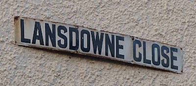 North End, North Way and North Cote relate to this development being built in North Field. Lansdowne Close, which was originally suggested to be named Macauley Road by the Health and Housing Committee, this was amended to Lansdowne Close, which makes much more sense as large parts of North Field were owned by Marquis of Lansdowne[a]. See also Bremhill View.
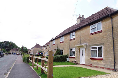 North EndNorth End was the first Borough Council housing estate for Calne and included North Cote, North Way, Bremhill View, Lansdowne Close, and the west side of Lickhill Road. The project began in 1920-21 with around sixty houses. At the time a three bed would cost 8s per week, while a four bed would set you back 10 shillings per week[1].
By 1939, a further 100 houses were built, with more after the war. Pre-war builds included Housing Schemes 3, 4, and 5: North End Housing Scheme No. 3 planned during 1932, with a tender out for 36 three bedroom houses being won by J.C. Wallis[2][3][4]. Another 56 houses were out to tender in June 1938 as schemes 4 and 5, which cost £22,420 with the contract going to E.J.G. Morgan at a cost of £13,236. The other costs for sheds, architects' fees, a Clerk of Works, etc[5].
In the 1960s, this development was extended by Maurice J. Morley & Company, who created Northfields, Braemor Road, and Corfe Crescent as part of their Northend Building Estate.
References:
[a] 'Lansdowne Close' Wiltshire Times and Trowbridge Advertiser, Saturday 14 January 1939 [ONLINE] Available at: https://www.britishnewspaperarchive.c... [Accessed on 26 September 2019]
[1] 'Borough of Calne' Wiltshire Times and Trowbridge Advertiser, Saturday 24 June 1922 [ONLINE] Available from: https://www.britishnewspaperarchive.c... [Accessed 26 September 2019]
[2] 'Borough of Calne' Wiltshire Times and Trowbridge Advertiser, Saturday 07 May 1932 [ONLINE] Available at: https://www.britishnewspaperarchive.c... [Accessed on 26 September 2019
[3] 'Calne Town Council' Wiltshire Times and Trowbridge Advertiser, Saturday 14 May 1932 [ONLINE] Available at https://www.britishnewspaperarchive.c... [Accessed on 26 September 2019]
[4] 'The end of Council building schemes' Wiltshire Times and Trowbridge Advertiser, Saturday 18 June 1932 [ONLINE] Available at: https://www.britishnewspaperarchive.c... [Accessed on 26 September 2019]
[5] 'Calne, £22,000 Housing Scheme' Wiltshire Times and Trowbridge Advertiser, Saturday 16 July 1938 [ONLINE] Available at: https://www.britishnewspaperarchive.c... [Accessed on 26 September 2019]
Place names of Calne: Brewers Lane

I have been, so far, unable to find the origin of the name 'Brewers Lane', which is relatively recent, there is a care home called The Maltings on the Shelburne Road side. There were certainly brewers and maltsters in Calne over the centuries and families called Brewer in the town. The road also goes by the informal name of Piggy Lane, as pigs used to be walked up the road in droves.
Brewers Lane replaced a footpath and foot bridge in 1904. A contemporary newspaper article calls it 'The Bridges Road' for the purpose of the report, but it didn't seem to have a name at that point:
'The New Road from Shelburne Road to Cow Lane crossing the Marden on two seperate bridges is completed this week and is now open from end to end'
The Shelburne Road side was more easy in descent than was aparently expected, however the Cow Lane (Anchor Road) junction was then as it is now 'abrupt and awkward'. However it was acknowledged that it would be of advantage to the residents to the north of the new road[1].
The road was first proposed the previous year as a way to relieve traffic in Church Street, which then as now, was a narrow thoroughfare. The expected cost was £85[2].
From the Anchor Road side, Brewers Lane would have originally been the entrance to Kew Lane Mill, which has long since been demolished. This began life as a clothing mill, which in 1228 belonged to the lord of Compton Bassett manor[3]. It belonged to the lord of Compton Bassett between the 17th and 19th centuries, during which time it was used partly for fulling. In the 1800s, the Marden could drive the machinery to make sixteen broad cloths in a week. William Pinniger, who wanted to quit the business attempted to relinquish the mill, but it continued until William Pinniger and Sons became bankrupt in 1827.
By around 1840, the mill was converted to a corn mill and remained so until the 19th century. In 1867 it was being let by Mr. Spencer of Bowood as a flour mill with two pairs of stone, which may be increased to three pairs[4].
1856 saw the tragic death of John Bush, nearly 2, who accidentally drowned close to Kew Lane Mill. The poor boy was found by Mary Ann Lodge of Kew Lane Mill, and her father brought the body out of the water. As part of the verdict, it was recommended that fencing on both sides of the bridge be made more secure[5].
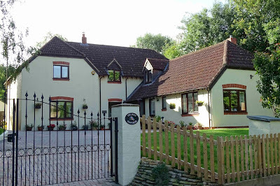 Island Cottage, Brewers LaneAt some point, by Thomas Cruse's 1828 map, probably to service the mill, the Marden was split, creating an island, which was the site of a piggery and a poultry house. In the recent past with three cottages were built, one named Island Cottage.
References
[1] 'The Bridges Road' Wiltshire Times and Trowbridge Advertiser, Saturday 19 March 1904 [ONLINE] Available at: https://www.britishnewspaperarchive.c... [Accessed on 25 September 2019]
[2] 'The proposed new road' Wiltshire Times and Trowbridge Advertiser, Saturday 20 June 1903 [ONLINE] Avialable from: https://www.britishnewspaperarchive.c... [Accessed on 25 September 2019]
[3] Calne: Economic history | British History Online. 2019. Calne: Economic history | British History Online. [ONLINE] Available at: https://www.british-history.ac.uk/vch/wilts/vol17/pp79-94. [Accessed 25 September 2019].
[4] 'Flour mill to let' Devizes and Wiltshire Gazette, Thursday 26 September 1867 [ONLINE] Available at: https://www.britishnewspaperarchive.c... [Accessed 25 September 2019]
[5] 'At Calne, on the body of John Bush, nearly two years old' Devizes and Wiltshire Gazette, Thursday 24 July 1856 [ONLINE] Available at: https://www.britishnewspaperarchive.c... [Accessed on 25 September 2019]


