
New features in Navionics app allows boaters to use satellite photos for navigation
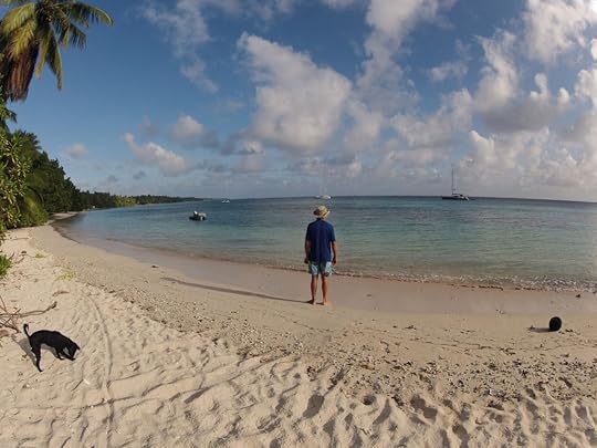
Wayne and Ruby on the beach at Eneko
by Christine Kling
I’ve been fascinated with iPad navigation for quite a while and with our newly repaired rudder, we took off last Monday and motored across the Majuro lagoon to Eneko, one of the smaller islands that form this atoll. I’ve blogged here before about navigation apps and there have been some big changes in the offerings from Navionics. When Apple introduced iOS7, they redesigned their app and it may well become my favorite nag app. The trip to Eneko gave me the chance to try out these new features in the Navionics app, and it’s so cool!
At Eneko there is a small facility onshore, the Eneko Island Bungalows, where intrepid travelers could sleep as long as they brought their own food. I took the photo above on one of our hikes ashore to give some welcome exercise to Wayne’s dog, Ruby. Technically, she is quarantined to the boat, so she had not been ashore since Fiji, and it was really fun to watch her absolute joy at running on the white sand beach, digging for crabs, and barking at the giant pig.
One of the big issues with cruising in the Pacific is the fact that the nautical charts for the area aren’t very good. The governments of the world that have financed the surveys and kept the charts more or less up to date are mostly concerned about commercial shipping. Cruising yachts don’t account for a big enough market to make it worthwhile to survey all the little corners where they want to visit. This means that the entrance to a big commercial port like Majuro is well charted. You can count on the entrance channel being in the spot where the chart says it is. But the small islands around the rim of the atoll? Probably not. What is so cool about the new iOS7 version of the Navionics software is that it allows users to pull in the satellite images from Bing or Apple’s Maps and overlay those images onto the chart.

So here is the chart with our original track out to the island of Eneko. It really looks like we went right up to the shore and we’re anchored on top of the island’s tip, right?
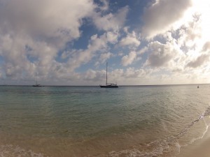 Okay, but here is a look at where Learnativity was really anchored. The bottom does drop off very quickly so we were close to shore, but not on top of the land! Look again at the chart above. Atolls are formed by the coral reefs that grow around the perimeter of high volcanic islands. But throughout hundreds of thousands of years, the soil of the islands erodes and the islands disappear. Only the coral necklace of small islands remain, but because they grew on the shores of these steep volcanoes, the drop-offs are incredibly steep.
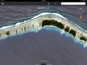 So, to really get an idea of how steep to these islands are, take a look at this satellite photo of Eneko. You can easily see the reefs and the lighter color is where there are depths of about 20-40 feet and yachts can anchor. There are also 4-5 moorings at Eneko so that yachts won’t damage the coral, but they were all occupied when we arrived.
Below is the chart that you can create with the Navionics iPad app by using the overlay with the satellite photo from Bing. The chart now shows the islands with a black line.
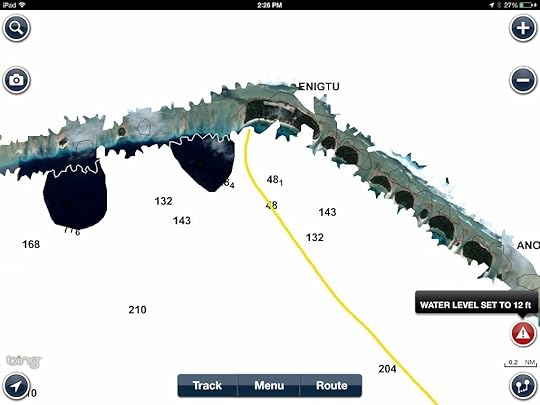
Look at how poorly the islands line up with the satellite image. You can see that the islands are pretty far out of their charted position. Can you imagine how relying on the charts could get you in trouble? The app also lets sailors play with the settings so that the satellite photo will cover more or less of the nautical chart. I’m still learning how to tweak it to make it work best for me.
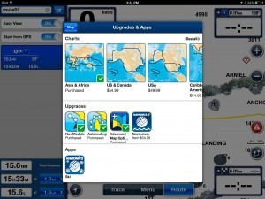 The Navionics app is “free” but you have to buy the charts through an in-app purchase. And you have to make an extra in-app purchase of the $4.99 Advanced Mapping module to get this satellite photo feature. I bought the Asia and Africa chart package (for about $65) which was what I needed to get Fiji and the Marshall Islands. And, of course, in order to get these sat photos, boats have to have Internet access, so that means they have to plan ahead and get these overlay charts made in advance. But, heck, this is so much better than relying solely on the charts.
I’m working on a Kindle book on Marine Apps for Boaters, so I’m curious to hear what you all think about these new features of the Navionics App. I hope you’ll leave some comments.
Fair winds!
Christine
Share on Facebook


 My first trip with Broad Reacher, my Freedom 28 was bringing her home to San Francisco Bay from Rhode Island. For a knot meter I had made a chip log. I had a plastic sextant for navigation and one book for working out the sites. I didn't get a GPS until my San Diego to Hilo trip years later and it was the first GPS that was boater available, the Garmin handheld that gave Lat-Long with no chart or plots in it. We certainly are making progress with this app you showed us here.


