
Jennifer Burge's Blog, page 2
September 8, 2016
The (truly) Great Ocean Road
At least, if you are anything like me, once you get over your cynicism that most places with the word “great” in their name are…well…not great. If you take nothing else from this piece, please know that this is one location that lives up to its name. If you should venture to this 151 mile-long tribute to the beauty of the southern ocean, you will not be disappointed.
Let us, for the sake of argument, imagine that you aren’t even an ocean-lover. (Yes, a trait that is hard for most of us to imagine, but still, I hear these folks do exist!) Will there be anything for you to do on this supposedly-great road? The answer is a resounding, “Yes!” Built by returned war veterans from 1919 to 1932 to honor their fallen comrades during WWI, this is the world’s longest war memorial. Given its unique location, the Ocean Road is full of history. From shipwrecks to historic villages, it is all here.
Though I have written about my first visit here, the Shipwreck Coast, in my second book Singapore Salvation and I shared some photos of it with you in January, it wasn’t until my third visit that I was the one with my hands on the wheel. This road, stunning and sexy as it may be, is a bit of a challenge. Last month, I made my way along it traveling from west to east which is the opposite way that most people travel as the largest nearby city is Melbourne, Victoria. This ended up working out mostly in my favor as the tour buses that leave the city in the early morning didn’t meet me until late in the day. As such, I had many of the beautiful stopping points largely to myself because it is winter. Where this didn’t work to my advantage was the early morning drive from Apollo Bay to Melbourne because a great deal of rain had produced generous rock and mudslides overnight. I was on the side of the road bordering land, not sea. It’s a good thing I have quick reflexes.
My Ocean Road trip began at Port Fairy, a lovely historic village that was originally a whaling station in 1835. It boasts over fifty buildings on Australia’s National Heritage list and I could almost have rested here for the remainder of my available time in the area—almost. Despite its picturesque scenery and probably the best pizza of my life at Coffin Sally’s, there is an unnerving vibe to the place. I didn’t feel unsafe. I thoroughly enjoyed wandering through St. John’s Anglican Church (1856). But there was something that felt “off” about it. Later, I discovered it had been the site of deadly conflict between the Irish settlers and native Aboriginals.
From Port Fairy, I lingered a little on my way to Port Campbell, hoping the rain would clear. Port Campbell National Park is where the heavy hitter of the Ocean Road lies, The Twelve Apostles. These limestone stacks are so uniquely beautiful that their image has been plastered over every possible advertisement for the area. So much so that I was surprised to be impressed by The Bay of Islands and The Bay of Martyrs which I came to before reaching the Apostles. The Bay of Martyrs was particularly cool (literally!) because of its beach access.
The next stop, Loch Ard Gorge, took my breath away—remember, we haven’t even hit the big time Apostles yet. You can wander this area, as I did, for hours, imagining what must have gone through the minds and bodies of those famously shipwrecked here on June 1st, 1878. You can also visit the cemetery nearby where they are honored. But simply looking through this magnificent channel and imagining trying to navigate it was my favorite part.
And then I hit the big time–the Twelve Apostles.
To enhance your mental picture, here is a stunning video of the area recently made by a talented former colleague and friend, Kris Eric, using a drone.
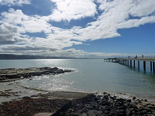
The Gibson Steps had been waiting for me since my first visit to the Ocean Road in 2009. A steep staircase built into the cliffs guarded by the Apostles allows you to photograph them from a different perspective—one more rarely seen by the masses that arrive at this incredible tourist draw hourly and fill its walkways. It was already late afternoon by the time I arrived and I was just in time to catch the sun low in the sky the beach turned to gold. For me, it was the realization of my dream was worth every step. The only problem was that I didn’t want to leave.

Sunset at the Gibson Steps, Great Ocean Road VIC Australia
Finally, I convinced myself to get moving as I still had a 1.5 hour drive before me and the sun was quickly disappearing.
I had forgotten that the Ocean Road (B100) takes a detour through Great Otway National Park at this point. Driving through dark, rainy forest roads is not my idea of a good time. At one point, I came into the last light of day and thought I might pull over to quickly sneak a peek at the sunset. That’s when I saw three police SUV’s with lights flashing and an ambulance coming my way. Slowly. As I passed, I saw a car being loaded onto the tow truck completely flipped on its backside. Needless to say, I didn’t stop.
(Note: if you do decide to make thi s trip–and you definitely should—make sure to stop in Great Otway. It is a gorgeous park teeming with wildlife and the road to the lighthouse is positively crawling with koalas. My husband and I spotted sixteen here on New Year’s Eve alone. The lightstation is equally intriguing and has an important spot in Australian history.)
It was a very slow and winding ride the rest of the way to my hotel at Apollo Bay. When I reached where it was supposed to be, I realized I’d missed the entrance. Turning around on a small unlit widening in the road overlooking the cliff and knowing the sea is below it is was not my idea of a good time. Continuing on for many more dark miles to try and find someplace else was even less so.
Drama subsided. The ocean (and a few glasses of red!) lulled me to sleep. I woke to the glittering Apollo Bay beach just to my right and the rising sun to my left. Fifty photos later, I was sure it was all worth it once again. Continuing east, I started to find those piles of earth and rock in my lane as I mentioned before and I was especially glad I did not drive further in the dark.

My reward for a less-than-relaxing drive to Apollo Bay in the dark
My parting gift was a peaceful beauty called Lorne. Lorne is one of the largest towns on the Ocean Road, but its size does not diminish its charm. The serene beachside setting is enhanced by a fishing pier and plenty of places to grab a bite or a quiet coffee and think about all you have seen. Though at times I thought I’d bitten off more than I could chew, I am pleased to have devoured this national treasure in its entirety. Previously, due to limited time and raging bush fires, I didn’t get the full impact of her unflinching rugged beauty. On more than one occasion, I was reminded that I don’t get to be here–as she has—for 150 million years. In comparison, I have less than a millisecond. I had better enjoy the ride.
The post The (truly) Great Ocean Road appeared first on Worldwise Publications.


July 28, 2016
Tales from Tokyo
This man, famous for eating everything under the sun and traveling to at least double the amount of countries I’ve been to, finds Japan’s capital city a challenge—but clearly one worth taking on. I thought about it for a while after I read the article and I have to say that I concur. Rarely have I been so completely lost in a place and yet so happy in it simultaneously.
To visit Tokyo is to experience sensory overload to the extreme. I realize that sounds painful but I guarantee it is anything but.
I had five days to visit a city of thirteen million people and twenty-three “special wards.” It is the most populous metropolitan area in the world and I was attempting to see it in only a few days. Tokyo is many things, but inexpensive isn’t one of them. I would have to make the best of it and hope to get back one day. Confession: I traveled alone, but met up with a local friend on the first day and another flew in on the second. For me, it was the best of both worlds. I could wander freely, but I could also make forays into the more daunting areas in the company of friends.
Choosing a hotel that had a shuttle from the airport and a nearby subway makes life easier—until you have to enter the massive underground and figure out where to go. I must have been wearing the “confused traveler” look on my face because I was offered help with finding the route to Kamakura within minutes. My only excursion outside the city was to see the Great Buddha in a town an hour south of the city. The ride gave me some context for the mega-metropolis and surrounding area as well as a hint of what life would be like in a village nearly one thousand years old.
Once I arrived, the route to the Great Buddha was very clearly marked. I was disoriented by my utterly foreign surroundings, but calm at the same time. Perhaps it was the influence of the second tallest Buddha statue in Japan looking down on me from its forty foot (13 meter) height. With closed eyes, draping robes, and broad shoulders, he has been imparting his flavor of zen on travelers since 1252. He has even withstood the tidal waves which destroyed the hall which one protected him since 1495. Talk about calm in a storm…
Returning to Tokyo, attempting to fit in the highlights was completing a puzzle in each direction. To the west, we survived Shinjuku—Tokyo’s busiest station—to advance toward the popular Meiji Shrine. Stopping to take a few quick picks of the Harajuku Girls known for their outlandish costumes (picture Little Bo Peep holding hands with a goth Vampire), we found the forest entryway to the famous shrine. A vast oasis of calm in the utter chaos of this densly-crowded city, the shrine area holds 100,000 trees donated from across the nation. The shrine celebrates Shintoism, the indigenous faith of Japanese people. Shinto has no scripture and no absolute “right” and “wrong.” I don’t know about you, but I like the sound of that.
Shinjuku is also the home of both upscale and lowbrow nightlife. Take a spin up to the New York Bar at the Park Hyatt for the jaw-dropping view over the sparkling city or take a seat where Bill Murray met Scarlett Johansson in Lost in Translation. Wallet a bit thin? Cruise over to Golden Gai, a maze of six tiny alleys stuffed with bars the size of broom closets—and rub elbows with the locals. (Be warned: this may come with a host of crazy characters, a great deal of sake, and a karaoke finale. But that’s a story for another time.)
To the north of Tokyo, the district of Asakusa is a major tourist draw. We headed toward the Sensoji Temple, eager to discover how it is different from its western neighbor. For starters, it is considerably older—built in 645 AD. The area that surrounds the temple continues to have the “old-world” vibe despite the nearby market streets called Nakamise which lend a carnival feel to the place. Near the entrance, my friend and I were approached by a young Japanese student who offered us a free tour. In most Asian countries, I would have found this deeply suspicious, but there was no doubt he was honest in his explanation that he needed to practice his English. He explained the legend of the temple’s creation in honor of the goddess of Kannon. Two brothers had fished her statue out of a river in 628 AD and though they returned her there—she kept returning to the spot we now stood. Eventually, they built the temple to keep her in. See how helpful the Japanese are? They will even build you a house when you need one.
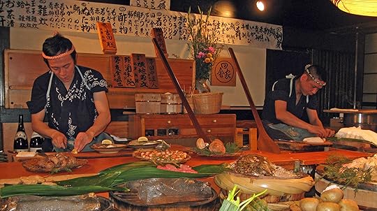
Southern Roppongi is for painting the town a very beautiful shade of red, one of which you may never have seen the likes of. In my case, color was called Inakaya—a Robatayaki restaurant—and I have never experienced anything like it again. From the moment we entered, there was shouting. Shouts of greeting! Shouts of ordering! Shouts of more sake arriving! Huge wooden paddles (or perhaps oars) are placed into something similar to an enormous pizza oven and roasted to perfection over the hottest coals imaginable. There’s that shade of red I was talking about. If you are very lucky, there will be a champagne bar afterwards—but all flavors are available in Roppongi. Let me tell you, choosing only one is a bitch.
Still awake? I haven’t driven you into the ground with exhaustion? Well, please do not forget central Tokyo! The Tsukiji Fish Market with its thousands of pounds of fresh sushi will not disappoint and the glamorous shopping of the Ginza is something to write home about.
What’s that you say? You’re tired? Welcome to the club! Tokyo will chew you up and spit you out, but it’s very likely you might not ever have had this much fun in your life. I expected to be impressed, but I didn’t expect to have the experience of a lifetime. Though I am eager to return, I’m a little skeptical at the same time. A trip like this cannot be duplicated—and it shouldn’t be! Something tells me that within all those millions of places and people, an even better one is waiting to be uncovered.
The post Tales from Tokyo appeared first on Worldwise Publications.
July 20, 2016
The Importance of Istanbul
Why should we all care? Because Istanbul is a pillar of history that assists us in telling the story of humanity since 6000 BC. Because it is colorful and diverse and secular and religious and straddles two continents. And not least, because freedom of religion and freedom of speech are under attack in a country that plays a critical role in stemming the free movement of radical terrorists from the Middle East to Europe and wannabe terrorists into the Middle East.
Massive times of history must be examined to determine which events allowed this ancient city to be the leadership seat of four empires. Yes, four. Istanbul, formerly Constantinople, holds the rare honor of having been a bastion of Christianity for centuries before its conversion to a Muslim capital. Not only has her religion been fought over for hundreds of years, but her 5,343 square meter area is divided by the Bosphorous Strait so that Istanbul resides in both Europe and Asia. If these theoretical and geographic challenges don’t scream “split personality”, I can’t imagine what would. And yet, charismatic Contantinople has capitalized on her unique set of attributes in a way that hasn’t been repeated throughout history.
Constantine the Great, credited with the shift of Roman power eastward, he became the emperor of the entire Roman Empire in 304 AD. It was he who transformed the city into a center of Christianity and Greek culture. For nearly 1500 years, the Romans ruled Constantinople as she grew into the wealthiest and largest city on the European Continent. The impressive Hagia Sophia, literally ‘divine wisdom’ was built in 537 AD and remained the largest cathedral in the world for over a thousand years.


To stand inside her walls is to feel her old soul live and breathe—and to hear the echo of her tears.
In the middle of the 14th century, the Ottoman Turks began a campaign to take over small Roman towns one by one. Over two months, when the last Roman Emperor had been killed, the slow strangulation of Istanbul’s supply routes ultimately weakened her to a state where the Turks could breach the city walls. The Romans (aka “Byzantines”) fled. Some made a fateful decision to take refuge in the holy cathedral, Hagia Sophia, and were slaughtered in it. Afterwards, Sultan Mehmet II called an imam to the building to declare it an Imperial Mosque. The imam proclaimed, “There is no God but Allah” and thus began the Istanbul’s transformation to a Muslim state. 13 minarets were installed on the mosque to call the faithful to prayer.
This too was a period of substantial development for the city. The labyrinthine Grand Bazaar was opened in 1461 and thrives today. Her 5,500 vendors and 65 alleyways are a trove of treasures too numerous to mention. Carefully-handcrafted carpets line the walls next to shining multicolored brass lamps. Fake leather Chanel bags mingle with sparkling belly-dancer costumes. Turkish delight and spices reign supreme. Stall owners still pay their rent–a hefty 7 kilos annually for shops on the main avenue–in gold.
The Turks also built the sultan’s official residence, lavish Topkapi Palace, in 1478. When entering the Imperial Gate, be sure to note the recessed niches included to display the severed heads of criminals and rebels. Topkapi Palace, the strategic command center of the Ottoman Empire, doubled as the pleasure palace with harems numbering into the thousands. No members of the harem were Muslim, however, as it is forbidden for Muslims to enslave Muslims.
World War I brought the end of the Ottoman Empire and the exile of the last sultan, Mehmed VI. The British, Italians, and French occupied the city until the Treaty of Lausanne was signed and brought official recognition to the Republic of Turkey. The long fought over Hagia Sophia was declared a museum, eliminating any argument over which religion would worship there. The decision remains controversial with Muslims calling frequently for the sacred building to be restored as a mosque.
Today, the future of Istanbul–and indeed Turkey–seems uncertain. As the gateway between East and West, her responsibilities are great—and so are the risks. President Recep Tayyip Erdogan is negotiating for his country to become a European Union member while instituting a number of strong-arm decisions that color him with dictatorial shades. This includes a recent call to restore the death penalty to deal with those involved in the coup attempt, something that all EU member states must strongly disavow.
The previously underlying current of distrust for Mr. Erdogan has raised its head above the surface. Protestors regularly share their displeasure with the shift to greater authoritarian rule. Add to this the vicious terrorist attacks which have lately claimed far too many victims and you can see why Turkey is on the brink. Istanbul’s critical position on the world stage must be supported from within and without. No stranger to conflict, any one man who attempts to dominate her will eventually face a fearsome wrath. Perhaps this was not yet the moment, but the moment may yet arrive.
The post The Importance of Istanbul appeared first on Worldwise Publications.
July 14, 2016
Bewitched by Bruges
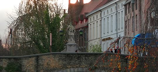
If you haven’t been blessed with a visit to Bruges, the diamond of West Flanders near the North Sea coast, please read on. If Brussels is your vision of Belgium, there is much to be added to the picture. Entering Bruges is to exit a time machine in the middle ages. The time when braided women created exquisite lacework by hand in doorways while a fire crackled in the hearth, ready for the evening meal. Flemish painters designed luxurious scenes to decorate the walls of well-dressed noblemen. Until the fourteenth century, Bruges was an important center of trade for the region and, increasingly, the world. She rose to her position early with city rights bestowed in 1128. As she matured, the Flemish wool market was established and in 1309, what is thought to be the first stock exchange in the world, the bourse, opened for business.
The Bruges of medieval times was poised for prosperity and promise. Until, catastrophically, she met an untimely death.
The tragedy of the 1500’s is the 21st century blessing of Bruges. The Zwim channel, Bruges’ lifeline to the North Sea, silted up and prevented the movement of goods, forcing merchants to move to alternate commercial centers, such as Antwerp. It was then that Bruges collapsed and assumed a Pompeii-like quality where she remained until she was resuscitated by modern machinery in the twentieth century. Visitors today will see nothing of the global economic powerhouse that was medieval Bruges. Instead, they are treated to idyllic waterways brimming with swans and the chance to peer at architecture so rare on our modern planet. To walk through the city streets is to have history at your fingertips.
Today, where nostalgia is queen, Bruges reigns supreme. It’s her face I long to see every year when summer gives way to autumn. September is perfection with her blood-red ivy crawling sunlit stone walls and canal breezes tickling your nose with a mouthwatering whiff of freshly-baked waffles. If you are feeling especially melancholy for a simpler time, take a horse and carriage to the Halve Maan Brouwerij and sample a sixteenth century Straffe Hendrik brew that will make you weak in the knees. If you’re very lucky, you will find your way to the secret annex of ‘t Brugs Beertje where hundreds of names like Chimay, Kasteel, and the ultimate, Brugse Triple, can be found standing at attention. Mark my words, however, that Belgian beer is nothing to trifle with–it is as deadly as it is delicious.
While we are on the topic of things not to be trifled with, the most famous landmark in the city–the Belfry–is well worth a mention. This striking landmark, the most recognizable in the cityscape, was born in the 13th century. It was added to the market square in the year 1240 and stands close to 300 feet (83 m) tall. As the climb to the top of the narrow staircase of 366 steps is no small effort, make sure to gather your strength, or at least your caffeine of choice, beforehand.
Though you may be tempted to write off the many canal boats due to their obvious tourist flair, I urge you to reconsider. There truly is no better way to get a feel for what the city was once like than by viewing it from the water. Bruges, already beautiful in her own right, takes on a completely different personality when you’re seated on one of these small tourist boats. Choose your time wisely, early morning or late afternoon, and you will be able to take advantage of the best light with your camera.
The authentic beauty of the so-called “Venice of the North” isn’t available to every tourist on a day trip. It’s rarely spotted by the busloads invading its plentiful tea rooms, as some quickly dim their lights when a phone call alerts the owner to the arrival of the masses. The reason Bruges remains a well-kept secret outside of Europe is that, after so many turbulent years, she knows to hold her cards close to the chest. With every rendezvous, she reveals a little more skin or allows one more tantalizing taste. Her mysterious charm keeps you coming back for more, but only those who respect her depth will get ever get to know her.
The post Bewitched by Bruges appeared first on Worldwise Publications.
July 7, 2016
Forbidden Frenzy
One would think that least of all, the former center of political and cultural life, the Palace Museum a.k.a. The Forbidden City, is the place you’d want to be. The entire nation has its annual celebration on October 1st and in the case of the sixtieth birthday party, it still hadn’t stopped when we arrived 8 days later. I can only say that I’m grateful our first stop was Shanghai because days later when we landed in Beijing, the festivities showed no sign of stopping.
I didn’t know what to expect of China’s ancient capital, but I had always been curious. Watching the Opening Ceremony of the 2008 Olympics in Singapore ratcheted that curiosity up several notches. Any country that could create such a spectacular with pure people power and creativity had to be worth a visit. I was not wrong.
On some level, I suppose the crowds helped put China and the Chinese in perspective. I can’t remember anywhere we went where we were alone and I suppose that gives an indication of why the Chinese always seem to travel in such large groups everywhere they go. They’re used to it. Smaller numbers must seem very odd to them.
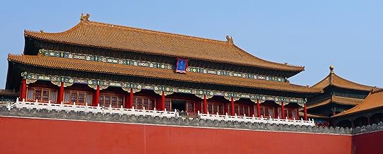
Walking to the Forbidden City, a place I had to visit based on name alone, I felt a little nervous. Even though now it is a museum and no longer the home of the Chinese ruler, it still felt, well.. forbidden. The name comes from a literal Chinese translation of the word, although there is more than one theory to explain it. The most-accepted explanation is that its name comes from one law: No one could enter or leave the city without the permission of the emperor. That in itself is a little foreboding and we haven’t even gotten to the 26 foot wall that surrounds the place.
This complex of nearly 1000 buildings has been the home of 24 emperors over nearly 500 years. Its construction began in 1407 and it was closed in 1920. Over this period, 14 Ming dynasty emperors and 10 Qing dynasty emperors lived here with their courts and households. It is well-known as the result of two thousand years of Chinese architectural knowledge and was World Heritage listed in 1987 as having the largest collection of ancient wooden buildings in the world.
If that doesn’t impress you, consider that the area is over 3000 feet from north to south (960m) and 2500 feet (750m) from east to west. All of this is surrounded by a 170 foot (52m) moat in the heart of Beijing. Inside the walled complex, the layout is in concentric rectangles that get continually smaller. This is what is difficult to conceptualize from photos of the Forbidden City, the design which symbolizes the reduction of the number of people who could be in proximity to the emperor.
The closer we get to his actual throne and chambers, the smaller the surrounding space and the less people who could interact with the celestial being in man form known as the “Son of Heaven.”
Inside the Inner Court, you will find the private chambers of the emperor and the empress. The emperor lived in ‘The Temple of Heavenly Purity’ and the empress’ chambers are known as ‘The Palace of Earthly Tranquility’ between them is the Hall of Union where they mixed up their yin and yang together.
But it isn’t only these grand halls, courts, and chambers that are striking. Personally, I was transfixed by the size of something that had once likely held fire but looked like it could be the biggest flower pot you’ve ever seen. The enormous red doors with brass lion knockers will make you feel like the tiny Alice of Wonderland fame. Every single rooftop and wall is decorated with Chinese hieroglyphics that reflect their native Taoism. Embroidered dragons and heavenly bodies cover the gorgeous golden robes of the emperor. This ruler who kept thousands under his thumb every moment of every day was revered by millions but known to very few. I daresay those he trusted numbered even less.
To walk these grounds as others have done since the 15th century is extremely humbling. I had a similar feeling in Rome, the feeling that my worries were so insignificant and fleeting in light of centuries of human trials & tribulation. Standing next to the ‘Gate of Supreme Harmony’, built to hold a hundred thousand people, gives you a small idea of the number of stories that China has to tell. I can only hope one day to be back in the ‘Pavilion of Literary Profundity’ to find out more. It’s a good thing that we had plenty of company on this visit. A place so vast would otherwise feel very lonely–something the emperor knew all along.
The post Forbidden Frenzy appeared first on Worldwise Publications.
June 30, 2016
Put-in-Bay Perspective
Once upon a time, there was a young girl who lived in Ohio. She spent every summer swimming and boating on beautiful Lake Erie and felt very lucky to grow up down the street from the beach. As she got older and began to travel far and wide across the planet, she was often asked by people where Ohio was or if it was only farmland as it looked like on American television and films. Though she explained that she was from the Great Lakes, they had often never heard of the Lake Erie Islands. For all those blank stares she received when mentioning the islands, she will now tell you all about the playground of her misspent youth, Put-in-Bay—also known as South Bass Island.
Put-in-Bay has a disproportionately large history for tiny size. Under four miles in length, the year-round population was last counted at 138 people in 2010. In the summer, however, college students and boaters number in the thousands. The bay’s unique name has various urban legends associated with it, but is thought to have come from the expression of sailors to “put it in the bay” when seas were too rough to sail. There is also a theory about the bay being in the shape of a “pudding bag” but since I don’t have any idea what that is, let’s move on.
One cannot visit the island without seeing the enormous Perry’s Victory and International Peace Memorial which stands at 352 feet high. The monument commemorates Commodore Oliver Hazard Perry’s victory in the Battle of Lake Erie during the War of 1812. Though the battle is largely lost in world history due to the Napoleonic Wars of the same period, it was significant for the fledgling nation of the United States of America and is often referred to as the “second war of American independence.”
On September 13, 1813, Perry sailed from Put-in-Bay to take on the British Royal Navy and was victorious—capturing six British Navy vessels and issuing the declaration:
Dear General —
We have met the enemy and they are ours; two ships, two brigs, one schooner and one sloop.
Yours with great respect and esteem,
O.H. Perr y
Considering that it was the first time in history that an entire British squadron had surrendered, Commodore Perry had just made a very big name for himself and catapulted this small Ohio island into the history books forever. Today, the monument stands less than five miles from the longest unguarded international border in the world and commemorates over 150 years of peace with Canada.
In the 1860’s, a German count bought nearby Middle Bass island and imported German experts to begin wine-making on the island. By 1875, the Golden Eagle Winery was the largest wine producer in the United States. French-Canadians were making wine on North Bass as well. The cool climate Reislings of the area were becoming well-known as tourist boats brought city folk for day trips.
By 1888, five luxury hotels had been built on South Bass (Put-in-Bay)—including the largest resort complex in the United States at the time and the first co-ed swimming pool. Vacationers flocked to the Lake Erie Islands to get away from it all. Steamers then began moving between Toledo, Detroit, and Cedar Point ferrying 150,000 tourists a season. At one point, twelve steamers a day stopped at Put-in-Bay—but the Depression and Prohibition put an end to all that fun and frolicking for years to come.
Though the island has always been a summer resort town for Ohioans, it suffered greatly from the severe lake pollution of the 1970’s. That was the decade I first laid eyes on this little beauty from the deck of a sailboat and it remained a favorite stomping ground for the next twenty years.
Today it is known for water sports and fishing along with the time-honored pastimes of drinking and debauchery. There are world-class walleye and sailing tournaments as well as a plethora of new hotels and accommodation choices. When I visited last summer for the first time since the 90’s, I barely recognized the place I’d once known. She is all grown up now with twenty-five bars to choose from.

Put In Bay (aka South Bass Island), Ohio June 2015
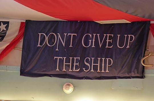
Despite its turbulent ups and downs, “the Bay” remains a favorite place and one I’ll never hesitate to go back to when the opportunity appears. Lake Erie boaters are a friendly lot and one known for their laid-back attitudes. Though there is no doubt that the place remains special to me for its many memories, I’d venture to guess that first time visitors will relish the island’s sun and fun as much as anyone who has a history there. You may not make the books in Commodore Perry-style, but you’ll surely have an experience not soon forgotten. Just remember, not matter matter how many cocktails make their way to you–be sure to borrow a page from Perry’s battle plan and “DON’T GIVE UP THE SHIP” or you’ll have a very long swim in your no-so-distant future.
The post Put-in-Bay Perspective appeared first on Worldwise Publications.
June 16, 2016
Rock The Cradle
Separated from the mainland by the Bass Strait, “Tassie” (note for Americans, pronounced “Tazzie”) has the second oldest capital in Australia. While the island was originally sighted by Dutchman Abel Tasman and named Van Diemen’s Land, it was the Brits who created the first European settlement on the island. It was called Hobart Town in 1803—now known simply as Hobart. As the original settlers to the island were mainly convicts and guards, Tasmania’s early roots were brutal. I’ve written about the infamous Port Arthur penal colony, but there were several others established on the island as well. Original structures from the English settlers still stand in Hobart, but today the city has a thriving gourmet food and arts scene along with successful fisheries of all varieties—but I will have to save my rave reviews for the capital for another day.
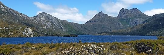
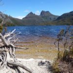
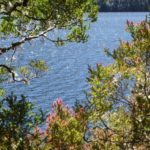
Outside of the two main cities, Hobart in the south and Launceston in the north, lies a staggering abundance of natural beauty. In nearly any direction you choose, Mother Nature will be there to blow your mind. For us, the destination was northeast through Lake Saint Clair National Park to Cradle Mountain Wilderness Village where we would spend four days exploring. Though I wasn’t brave enough to take on the 6-day wilderness trek known as the Overland Track, Cradle Mountain held plenty of adventure for my husband and I. Waterfalls, hiking trails, and wildflowers were more than sufficient to hold my attention. Throw in the rugged rocky terrain and glacial lakes and we have ourselves a winner.
What we did not anticipate, as we had yet to learn that the whole of Australia goes on holiday during Christmas and New Year’s Day, was the crowds of people who would be joining us on these mountain trails. For that reason, I was very pleased with the stand-alone cottage we booked in the Wilderness Village. Though the place was fully booked, there was no noise at night besides a very ornery Tasmanian devil and a few perturbed possums. This I could handle.
To limit the extent of damage to the environment by the masses who pilgrimage to this mecca of natural wonder, the parks service has introduced a bus service to carry hikers and tourists into the park. Cars are not allowed to enter. As these buses swing by numbered stops every fifteen minutes or so, it’s a very convenient way to go. Dropping by the information centre, the friendly guy at the counter gave me a tip. “Get off at the first stop and walk the trail in reverse. Everyone else will ride until the end and get off at the beginning of the trail to start at the same time.” Ben, you are still my hero.
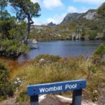
We left the crowds behind on the bus and made straight for the trails. It was here that I saw my first wombat in the wild. Two important things to know about wombats. First, if you clicked on the link you already know that they are ridiculously adorable. Not smart, I understand, but adorable. As such, you may delay your hike considerably upon spotting one because the camera will simply have to come out. Second, their poop is square. I know what you’re thinking, “Mother Nature, you crazy woman—what the hell?” Apparently, they use these little bricks to mark their territory on top of rocks. Because they are square, it doesn’t roll away. Yes, seriously.
But enough about wombats, the place is gorgeous. Even in mid-summer, you can expect some fairly wild weather in Tassie and we were blessed with the perfect hiking temperatures—the kind where you can wear a jacket, jeans, and long sleeves and feel perfectly comfy climbing some steep rocky trails. At the summit of Cradle Mountain, I overheard a guy remark, “It’ll keep the snakes away at least.” That opened my eyes a bit. I’d gotten used to them in Queensland, mainly because you rarely seem then and I’d taken that for granted here too. “Nothing to see here folks… just keep walking,” said the voice in my head and so I did.
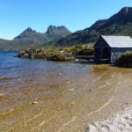
Thousands of photographs and miles later, we reached the end of the trail at the base of Cradle Mountain. If you haven’t Googled the place yet, do it now. I’ll wait… Though I have many, many beautiful photos of the mountain that takes its name from its cradle-like shape and the iridescent sapphire lake before it, I am not a professional photographer. For many of them, this is a favorite spot—in fact I think they were all gathered at the base of the lake elbowing each other out of the way to get the best shot. For a minute it was mildly entertaining to watch the pissing match before we moved on.
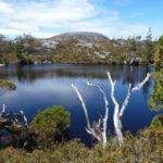
Midway through the morning, the sun made her grand entrance. She lit up the lakes to a crystal blue and created flares of the pink wildflowers along the Lake Saint Clair shoreline. Every step was worth it. That is until I nearly stepped on a Tiger snake who had come out to sun himself. (Note for Non-Aussies: Tiger snakes are baddies.) You do not want mistaking your toe for a foe if you know what I mean. The sun had indeed brought them out and several more slithered by in our last hour at the park. Regardless of the temperature, hiking boots, jeans, and thick socks are without a doubt the way to go.
As we rejoined the masses and waited in the long bus line, I was pleasantly worn out and grateful someone else was driving. Even better was the giant spa tub in our cottage that welcomed our weary bones home. With a little preparation and an advance booking in high summer, Lake Saint Clair National Park and Cradle Mountain offer some of the most spectacular views Tasmania has to offer. I would keep an eye out for square poop, however. Even if the Tiger snakes don’t make your acquaintance, that doesn’t mean you aren’t in serious danger of a serious overload of cuteness.

The post Rock The Cradle appeared first on Worldwise Publications.
June 9, 2016
A Whale of a Time
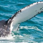
When I relocated to Queensland in 2011, I already knew about its incredible marine life. I’d visited the Great Barrier Reef and the fantastic beaches of the Sunshine and Gold Coasts, so I thought I had a grip on the situation. As with everything else in Australia, it turns out I knew next to nothing. The last five years have been a process of learning. Cyclones, shark species, rip tides, jellyfish, sea turtle breeding—need I say more? Yes! The list would be far from complete without a mention of the annual migration of humpback and southern right whales along the coast. With the average whale migrating 5000 kilometers (over 3000 miles), this is an event not to be missed.
As luck would have it, my home town of Brisbane is smack in the center of the migration superhighway. There are some 45 species of whales within Australian waters and the migration which takes place from May to October to and from Antarctica offers locals and tourists incredible opportunities to interact with them. When I learned this, my heart swelled with so much joy I didn’t think my chest could contain it. Every year for months at a time, I would have the chance to go whale watching. Even if you don’t take a formal tour, you can often spot the whales spouting and playing along the coast of my state and neighboring New South Wales.

AUS whale migration
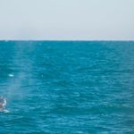
The first excursion I took with my husband was a boat trip on nearby Moreton Bay. The whale-spotting boast leave from Redcliffe a few times daily and its proximity to Brisbane makes it an easy day trip. We went close to the end of the season in October and it was a great day out on the water. We saw one or two whales, but unfortunately we weren’t very close to them. We’d also spotted them from the beaches near us—but again they were too far out to get a good look.
Hervey Bay changed everything. This sleepy seaside town on the Fraser Coast is roughly a three hour drive from Brisbane, so a weekend was required to make the most of a day on the water and we were far from the only people doing this. On Saturday morning, the packed marina saw fully-loaded vessels leaving several times an hour with multiple tour operators using it as their base. Because Hervey (pronounced “Harvey”) Bay is such a quiet town, I didn’t expect all the ruckus. It was only then that I understood what it meant to be in the “Whale Watching Capital of Australia.”
Our boat, aptly named Whalesong, cruised onto the bay’s shimmering waters and I gripped two cameras tight with anticipation. Families and travelers from around the world smiled nervously as they sipped hot coffee to stay warm during the winter morning. My husband and I planted ourselves on the ship’s bow hoping for the best vantage point to see the ocean on both sides of the ship. I tried to appear calm, but anticipation of what we might see was getting the better of me.
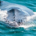
As we cruised, information was given to us about the type of whale behaviors we could see and the captain said were “guaranteed” to have sightings on this calm sunny day. I took that comment with a grain of salt as nothing in the world of wild animals is guaranteed—but I like optimism, so I tried to believe. Next came the whale song of the humpback at full blast over the speakers. Judging from the smiles on the faces of my fellow whale-spotters, optimism is contagious.
Soon, the whales were spouting in the distance—many of them. My heart pounded as I cursed the limits of my zoom lens and got nothing but fuzzy fins. My husband and his giant new lens fared better than I, but it didn’t take long for the curious giants to move right in. What started as a calm morning had turned later to higher than average swells. It was incredibly difficult to hang on to the boat and the camera at the same time and I eventually gave up.
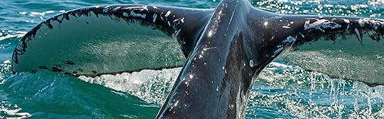
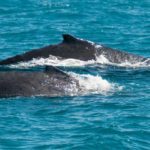
Sitting on Whalesong‘s bow was an experience I’ll not soon forget. These playful giants who head to Queensland’s warm waters for an eating and breeding holiday are nothing short of magnificent. Their slick black and white tails slapped at the crystal blue waters as though they were applauding the human ability to stay standing while the waves tossed our boat around. They came in groups of twos and threes and seemed to enjoy surprising the two-legged creatures on deck with their antics.
We watched them breach and spy-hop and you could swear they were looking you in the eye. Our cameras were little match for the action, but it didn’t matter. Seeing something the length of 5 cars glide below you and knowing it is the same weight as eleven elephants is a feeling it’s difficult to describe—uneasy and magic in equal measure.

Whales have not always had such a joyful time on the Australian coast as whaling was one of this nation’s first industries. Luckily the 1960’s saw the beginning of a shift in attitude against hunting whales and legislation for their protection was drafted and eventually enacted—but not for all species. The killing of sperm whales (mainly) continued until 1978 with tens of thousands disappearing from the seas of the Southern Hemisphere.
Now, with acts firmly in place and coastal regions patrolled, whales numbers have increased to the point at which you are “guaranteed” to see them. There is even an app for tracking your own sightings and seeing those of others to know where along the coast to find them. And even though the marine protection act states that boats must remain 100 meters (328 feet) from whales at all times, the latest development includes tours where you can swim with the whales. I must run along now as I’m late for another date with the cetaceans. The Greek word for “huge fish” tells me I simply have no choice. Care to join me?
The post A Whale of a Time appeared first on Worldwise Publications.
June 2, 2016
Cruising The Coromandel
I just finished my fourth trip to New Zealand. The greatest draws of this incredible country have always been its remoteness and natural beauty. From what I have seen of the world, they are unparalleled–except perhaps in Canada and Alaska. This is why much of my time there to date has been spent on its South Island, well-known to outdoor enthusiasts for its majestic mountains, glaciers, lakes, and parklands. It also happens to be less inhabited than the North, a win-win. This time, my thinned out Singapore-Queensland blood and the impending New Zealand winter demanded that I remain on the North Island. This was my first stroke of luck.
Landing in Auckland and picking up my rental car at two o’clock on Monday afternoon, I thought I had made a major error in planning. The traffic was insane. The rain was blinding. I was already cold. A little theme song played in my head about my propensity to drive forward without a great deal of planning—the words of which I cannot repeat in mixed company—and I thought I was in for a miserable week.
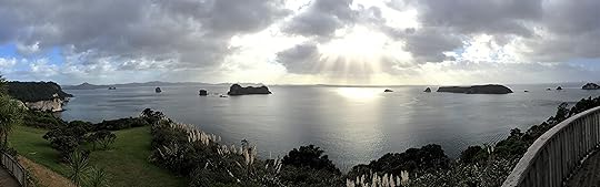
Only an hour passed this way before the skies cleared and the sun lit my way through the winding roads of the pristine Coromandel Peninsula. I knew very little about this place, other than what Lonely Planet had to say about its sights and accommodations and the fact that it is the playground of citified Aucklanders in summer. A two hour drive from the city, it is the perfect distance for weekend getaways.
Discovering that this region was a mix of rugged forest and tiny beach towns was me hitting the lottery. The sun stuck with me until I reached my hotel in Hahei, but only just. As I chatted with the friendly proprietor of The Church, darkness closed in. Luckily, Anna was prepared with flashlights and advice about where to dine along with providing the keys to my luxurious little cottage for the night. This is something I have noticed about kiwis, they are always ready to impart information about how best to enjoy their country. Traveler beware, however, of their inclination to tell you anything is “just a wee walk” down the road or up the beach. Before you know it, you’ll be struggling up a steep incline wondering how the locals are running past you in flip-flops (aka “jandals”) while you wish for your hiking boots.
That evening, a rainstorm of epic proportions set in and I again wondered how the week ahead would look if I were trapped indoors by it. Under slightly clearer morning skies, Anna and I talked briefly about the area’s biggest attraction, Cathedral Cove, and I took her advice once more about getting access to the beach track from the town parking lot. It was early when I arrived and I had the nothing-short-of-amazing view all to myself. It was so compelling that it took me thirty minutes to notice that the track and sole land access to the Cove was blocked off by yellow police tape. Nothing like travel to take you from soaring heights to despair within minutes!
Undeterred, I drove the few minutes down to Hahei Beach to see where I could go from there. Sadly, the only path led up to the same lot before descending again to the Cove on the other side. Just then, a lucky group of kayakers crossed the silvery morning sunlight on their way to the cove and I deeply regretted not being one of them.

Kayakers heading from Hahei to Cathedral Cove
Feeling in my pocket for the tear-off map of Hahei Anna had given me, I discovered a list of phone numbers for local businesses on the other side of it. Hahei Explorers sounded like they would fit the bill and I dialed. Sure enough, Shane said another tour was leaving in half an hour and there was plenty of space. SOLD! “Meet me at the blue tent at the south end of the beach,” he said. Looking up, I could see it from where I stood. This was my second stroke of luck.
The third came with the brilliant rays of sunshine that lit up the ocean as Captain Tom drove us onto the bay. The aquamarine South Pacific waters of Gemstone Bay,

Snapper, Te-Whanganui-A-Hei Marine Reserve, Hahei NZ
Stingray Bay, and finally Cathedral Cove are magic to behold. This area is the Te Whanganui-A-Hei marine conservation park–fully loaded with curious fish galore. The snapper seem practically domesticated as they rushed our boat for a peek. I could see them so clearly that I didn’t recognize them until Tom mentioned that in the ocean they have sapphire spots that they lose when in tanks or captivity of any sort. The intensity of their blue markings revealed this to be friendly territory.
Past Cathedral Cove and off of Cook’s Beach, Tom pointed out Mercury Bay. Cook’s Beach is named for Captain James Cook, a man I’ve been following around Australia and New Zealand for what feels like decades. Cook landed on this beach to watch Mercury transit the face of the sun on the 9th of November 1769. By doing so, he planned to determine New Zealand’s longitude and distance from Great Britain. While he was there, he stuck a flag in the ground for King George III and put New Zealand “on the map” for the first time.
Though there isn’t time to expand on the rest of my adventures in this installment, I will say in summary that my luck held for the majority of my visit and I learned a great deal about the unsung praises of the North Island. I discovered that to see an example of New Zealand’s pristine wilderness, you only have to drive a few hours from Auckland. While I fully recommend flying to south to Queenstown if you have the time, the Coromandel is a stunning example of what’s on offer throughout this beautiful country. With only five towns that have a population over one thousand, you can be on your own or have as much company as you wish for. Above all, do not fret if Plan A doesn’t come together… just look for the blue tent a wee walk up the beach.

Close Up of Cathedral Cove

View from a coastal cave

Coastal View of Cathedral Cove
The post Cruising The Coromandel appeared first on Worldwise Publications.
May 8, 2016
Franz Josef Glacier, The Emperor’s Retreat
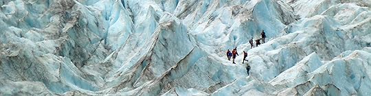
The fact that I would one day walk on a glacier never occurred to me. When I had the opportunity to hike New Zealand’s Franz Josef in 2011, there was no way of knowing that global warming would make sure I was one of the last tourists to do so. Either I am aging at the speed of light or the environment is simply collapsing under the weight of mankind. I tend to think it is the latter. It is still possible to walk on the glacier, but rather than hike up it from the valley floor as my husband and I did, visitors must now be taken to the top by helicopter.
The magnificent Franz Josef Glacier is one of two glaciers that make up Glacier Country on the west coast of New Zealand’s South Island. While the entire island has a mystical beauty that I have often written about, each of its individual treasures deserve further discussion. Perhaps because New Zealand was originally part of Gondwana, much of it—especially the South Island—gives visitors the feeling that they have traveled back in time. Formed over five-hundred million years ago, Gondwana was part of the original supercontinent and is still quite pristine today. Even now, it’s possible to imagine what the first European settlers and explorers felt upon their arrival in the early 1800’s. “Awe” is not to strong of a word for the first time you set foot here.
The glacier was given the name Franz Josef (simply “Franz” to locals) by German explorer Julius von Haast in 1865 to honor the Austrian Emperor Franz Joseph I. The slightly more imaginative Māori people have known it by another name, Kā Roimata o Hine Hukatere (“The Tears of Hine Hukatere”). Legend says that avid female mountain-climber, Hine Hukatere, wanted to share her passion for it with her boyfriend Wawe. Sadly, Wawe was not very experienced when it came to mountain-climbing and was swept to his death by an avalanche. Hino Hukatere was so sad that she cried a river of tears which froze and resulted in the glacier we see today.
Today, Franz Josef is about twelve kilometers in length. Over the years of documented history, it has had several periods of “advance” or (growth from additional freezing) and “retreat” (receding due to melt). From 1983 until 2008, the glacier advanced nearly 1.5 kilometers from heavy snowfall. In 2008, however, the current phase of retreat began and is occurring at an accelerated pace with 500 meters of melt documented by 2012. The increase in melting is attributed to global warming.
My husband and I were two of the 330,000 annual visitors to Franz Josef in 2011 and I fully admit that I had no idea what a “glacier hike” entailed at the time of booking. Once the day was imminent and the rush and hustle of arrival in the past, I wondered if walking on ice was actually a good idea. When my research showed that this hike had been a tradition for over a hundred years, my anxiety decreased. That is, until a woman handed me a pair of crampons with 2.5 centimeter spikes and instructed me to put them on.
I sat down on a block of ice and listened to her explanation carefully. The last thing I wanted to do was come plummeting down the glacier rather than make the slow climb upward. If I needed crampons on my feet, exactly how dangerous was this? I knew an Australian man had died of a heart attack on a similar climb the year before and I had just signed a waiver that the company taking us on this journey wasn’t responsible for my death if it should occur—but our smiling guide didn’t seem to be hiding anything and our group wasn’t exactly small. There were at least twenty-five of us struggling with this foreign equipment. My husband, usually the more cautious of our duo, had a look on his face that said, “What are you waiting for?” I took a deep breath and strapped them on.
Getting them on my feet was one thing. Walking was quite another. It’s a fair statement to say it was slow going. Fortunately for me, the rest of the gang wasn’t moving at lightning speed either. The guides, however, were another story. At dawn, they had already climbed the mountain to check for weak spots in the ice and to make sure that the ice path was secure. I had to laugh when I saw a chainsaw lying nearby, just off the trail. Now I knew how they managed to created actual steps in the rock hard glacial ice.

 During our ascent at a (forgive me, I have to say it) glacial pace, we were treated to incredible views of the deep crevasses in the ice. Some of the guides repelled within them and perhaps a few of the tourists too. As for me, I kept my crampons on solid ground. It was fascinating enough just to walk within this incredible natural space and marvel at what Mother Nature had created over millions of years.
At the top, I was surprised to find that the ice appeared to be covered with black soot. Bits of black dirt and stone had traveled quite a distance after being swept up in the glacier’s path giving the underlying blue ice a supernatural hue. Dark clouds swept the skies at the same time we reached our summit and while I was pleased to have conquered the mountain, it was impossible not have a sense of foreboding.


This adventure remains a favorite. At the time, it was illegal for anyone to walk on the glacier unaccompanied by a guide because without training, it would be easy to end up in a precarious situation. In 2012, within months of our visit, the glacier was closed to the public–period. Melting ice was creating too hazardous a situation for all involved. Nearby Fox Glacier closed in 2014 for the same reason. Details about the melting and comparative photos here and video of the recent changes in compressed time here.
Despite the changes, I highly recommend visiting Glacier Country. Reviews report that the “heli-hikes” are quite incredible. You can also get spectacular views of the glaciers on land or by road. I am fortunate have experienced the intense nervous anticipation of crampon-walking up the face of the glacier, but at the same time I feel guilty for having contributed its decline. As more of our natural wonders wear under our admiration, it is a feeling I expect to be confronted with far too often.
The post Franz Josef Glacier, The Emperor’s Retreat appeared first on Worldwise Publications.


