
Matador Network's Blog, page 933
January 28, 2020
Atari-themed hotels

1970s gaming company Atari — known for iconic arcade and home video games Pong, Asteroids, and Missile Command — is throwing its hat into the hotel game. Although Atari’s been very quiet on the gaming side, it just announced plans for eight Atari Hotels in the US. The first of these hotels is slated to open in Phoenix this year and will be designed as a paradise for gamers.
Although few details have been released, the Atari Hotels website promises a “unique lodging experience combining the iconic brand with a one-of-a-kind video-game-themed destination. Atari Hotels level up hotel entertainment with fully immersive experiences for every age and gaming ability, including the latest in Virtual and Augmented Reality.”
Fred Chesnais, CEO of Atari, said in the initial announcement, “We are thrilled to partner with GSD Group and True North Studio to build the first-ever Atari branded hotels across the United States. Together we’ll build a space that will be much more than just a place to stay. Atari is an iconic global brand that resonates with people of all ages, countries, cultures and ethnic backgrounds, and we cannot wait for our fans and their families to enjoy this new hotel concept.”
In addition to Phoenix, hotels are also being planned for Austin, Chicago, Denver, Las Vegas, San Francisco, San Jose, and Seattle. 

More like this: The most unique hotels from around the world
The post Atari is opening video-game-themed hotels across the US appeared first on Matador Network.


How to get a permit for Havasu Falls

Getting a coveted hiking permit for Arizona’s Havasu Falls isn’t easy. Reservations go on sale at 8:00 AM on February 1, 2020, and there are only 350 spots available each day. Last year, most reservations were gone within five hours of going on sale, so you’ll have to act pretty fast to reserve your date of choice.
An extremely popular spot in Arizona, Havasu Falls is notoriously difficult to actually access due to the high demand for permits. Located on the Havasupai Indian Reservation within the Grand Canyon, Havasu Falls is perfect for camping, relaxing by the water, and marveling at the rock formations. Because the area is sacred to the Havasupai tribe, they don’t just hand permits out en masse. The limited number of permits is designed to preserve the landscape.
To get one, make sure you create an account on the Havasupai Reservations page and log in before 8:00 AM on February 1. Have your credit card details handy. You will be given the option to make a reservation — no phone reservations are accepted — and you will then choose your desired date. In 2019, the rates were $375 for a four-day and three-night visit (all reservations are for three nights).
And if you do miss out on a campground reservation, you can book a room at the Havasupai Lodge. Given the limited number of rooms, however, it may be even tougher to obtain a permit for the lodge than the campground.
More like this: Everything you’ve ever wanted to know about hiking Havasupai
The post How to get a coveted hiking permit for Arizona’s Havasu Falls appeared first on Matador Network.

January 27, 2020
The best ways to get around Miami

Welcome to Miami! Or, if you’re not here yet, congrats on planning a trip to this big, bright city full of sandy beaches and mildly disreputable characters. Beyond regular tourists looking to chill at the beach or party for spring break, Miami will also soon welcome a ton of visitors for a variety of awesome events — the Super Bowl next week, the International Boat Show in February, and Ultra Music Festival in March. But with many of the top attractions being extremely far from the airport, getting around Miami — or at least getting around cheaply or in a time-sensitive manner — can be a little more difficult than the average city.
Considering our world-famous South Florida drivers, a charming collection of people who either learned to drive during the Truman administration or take stop signs as a polite suggestion, renting a car is not a wise decision. That said, we have a ton of other transportation options at our disposal. To help make sense of it all, we’re gonna break down the basics of getting around Miami for you and throw in some helpful tips along the way, so your time here will be as seamless as possible.
Lyfts, Ubers, and taxis

Photo: lazyllama/Shutterstock
The first thing to know about getting Uber and Lyft in Miami is that we don’t have a designated drop-off area at our airport. Sure, you might see a sign for one when you walk outside, but much like literally every other traffic-related sign in this city, it is purely decorative. Your driver will pull up to the same curb as every other car, so you’ve got to keep a lookout.
Ft. Lauderdale, a slightly more organized alternative to MIA, has rideshare airport pickup located at the far end of each terminal.
If you are planning on calling your driver to explain where you are, also be aware that a great number of rideshare drivers in Miami do not speak fluent English. You can either get frustrated about this or brush up on how to say, “I’m standing by Door 6 at American Airlines,” en Español. Only the second one will help you.
If you’re here for the Super Bowl, Lyft will be operating a number of concentrated pickup and dropoff points throughout the city, from several downtown areas to accommodate people going to Super Bowl Live, to the Adrienne Arsht Center for Performing Arts, to the Miami Beach Convention Center. Hailing Lyfts here will likely be more efficient than trying to call one from your location.
Taxis are typically two to three times more expensive than rideshares in Miami, even during surge periods. They are useful, however, if airport traffic is completely snarled, since taxis have exclusive use of the inside lane at MIA pickup and won’t sit in traffic picking you up or leaving. Taxis have a flat rate leaving the airport of $21.70 to downtown, $32 to South Beach, and $27 to the Port of Miami. Beyond the airport, taxis are pretty much only beneficial if you’re in South Beach and need to go a short distance quickly, as you can hail one easily and won’t have to wait on it to find you.
Getting around Miami by train

Photo: Jonathan G/Shutterstock
Miami has a Metrorail, a fact about as widely known in Miami as the fact we have a professional hockey team. The Metrorail runs to Miami International Airport, Downtown Miami, Brickell, University of Miami, and… not much of anywhere else. So if you’re staying downtown or in Brickell for business it is useful, and only costs $2.25 a trip, and you can pay from your smartphone. If you’re going to South Beach, North Beach, Wynwood, Hard Rock Stadium, or literally anywhere else people visiting Miami like to go, it doesn’t even get close. So opt for a rideshare or taxi.
In downtown and Brickell, you can also take the free Metromover, a small, overhead tram that makes several stops around the area. It connects to the Metrorail at Brickell and Government Center stations, operating in clockwise and counterclockwise loops. You can view the whole map here and will find it most useful if you’re checking out the Miami Heat at its arena, or visiting Bayside Marketplace.
If you’re flying into Ft. Lauderdale, or staying in Ft. Lauderdale, or just want to see what America’s finest city of canals is all about, you’ve got a couple of train options. First, we offer the TRI-Rail, a public commuter train service that runs from West Palm Beach to Miami, making stops in Ft. Lauderdale and other cities along the way. The price varies by how far you go, but Miami to Ft. Lauderdale is about $7.
If you’re taking TRI-Rail from Ft. Lauderdale Airport, you’ll need to take a shuttle bus — which boards near the rideshare pickup zone — to the Ft. Lauderdale Airport Station. It allegedly runs every 15-20 minutes, but don’t hold your breath.
Your other option for cross-county transportation is our sleek new Brightline train, which has stations in downtown Miami, Ft. Lauderdale, and West Palm Beach. It will get you from Miami to Ft. Lauderdale in 25-30 minutes and from Miami to West Palm Beach in a little over an hour. It is, quite simply, the nicest commuter trail you will ever ride, with stations that smell like grapefruit, high-speed internet and booze carts on the train, and a first-class section where the food and drinks are free.
For visitors, it gives you an easy way to check out the rest of South Florida. It can also be useful if you’re flying into Ft. Lauderdale as it’s a short, $12-ish rideshare from Ft. Lauderdale-Hollywood International to the Brightline station. Train fares vary by time, but expect about $12 each way to Ft. Lauderdale and $20 to West Palm Beach.
Taking buses and trolleys in Miami

Photo: Studio Barcelona/Shutterstock
Though you may see a lot of them on the streets, buses in Miami are not all that practical for visitors. The most useful thing you’ll find is the South Beach Trolley, a free trolley that circulates South Beach in clockwise and counterclockwise loops. It’s a cheap, easy way to traverse the beach and though you’ll still get stuck in traffic, it won’t cost you anything.
You’ll also find Middle Beach and North Beach loops if you’re staying further up in Miami Beach, as well as a Collins Express trolley, which runs the length of Miami Beach making limited stops along A1A.
If you’re determined to save money getting from Miami International Airport to Miami Beach, you can catch the airport express bus just under the airport Metrorail Station. It costs $2.25 and will take you directly to 41st Street, then on to several stops south in Miami Beach.
A note on walking in Miami

Photo: pio3/Shutterstock
Perhaps you’ve read all of this and thought, “This sounds like a lot of time spent inside air-conditioned cars, trains, and buses, and I came to Miami to be out in the sun! I’m gonna walk everywhere.” While we applaud your dedication to fresh air and exercise, please remember a couple of things:
First, it’s hot here. And incredibly humid. And walking a mile will be a lot more taxing than it probably is back home, so bring extra shirts and drink lots of water.
But secondly, and more importantly, pedestrians in Miami don’t have the right of way. Yes, technically, legally, they have the right of way. But technically, legally, our politicians aren’t supposed to give construction kickbacks to family members. So never, ever assume a car is slowing down for you in a crosswalk, much less stopping. And don’t jump out into the street as soon as the little man says walk since a car may decide to make a right turn directly into you. Yellow lights mean speed up. Red lights mean three more cars, four if it’s rush hour. Just remember that in Miami, cars don’t stop for pedestrians, so proceed with extreme caution.
Armed with this knowledge, we hope you enjoy your time in South Florida. While we might not be the easiest city to traverse, at least you’ll have palm trees and turquoise waters to look at while you do. Whether you’re taking a rideshare, riding our trains, or hopping on the trolley, you’ll be getting a heavy dose of local flavor. And, thankfully, never have to drive an inch.
More like this: The best hotels in Miami right now
The post How to get around Miami like a pro, according to a local appeared first on Matador Network.

Cheap weekends to book a hotel 2020

Even though we’re nearly a month into the year already, your 2020 trip planning is probably still not done. Sure, you read about all the great places to go in 2020, and the even cooler places to stay, but with a bank account still depleted from the holidays and the drudgery of late-winter in full swing, perhaps your vacation motivation hasn’t been especially high.
Even with limited resources, though, you can still look forward to some short weekend getaways where traveling won’t cost you much. Hotwire examined the average hotel rates across every weekend of the year and found the weekends of each month when hotel prices will be the lowest. The results aren’t what you’d expect.
For example, if you’ve been mulling over a trip home for Mother’s Day or Father’s Day, but weren’t especially excited about sleeping in your parents’ new Active Living condo, you’ll be thrilled to hear those weekends are the cheapest to stay in May and June, respectively.
Ditto for Thanksgiving, when you can escape your family and slip into a food coma in your own private hotel room as that’s the cheapest weekend in November.
Other surprisingly cheap weekends: Fourth of July leads that month with average rates at just over $130 a month. Labor Day leads usually cheap September at $128.50. And Halloween is the cheapest weekend in October, with the October 30-November 1 weekend averaging $129.80. It’s possible that people just assume these weekends are going to be super expensive, so they don’t book them, and then the hotels have unsold rooms.
The rest of the year breaks down like this:

Photo: Hotwire
January 31 – February 2 (Groundhog Day) — $108.52
February 28 – March 1 (Leap Day) — $119.51
April 10-12 — $117.54
May 8-10 (Mother’s Day) — $120.12
June 19-21 (Father’s Day) — $127.40
July 3-5 (Fourth of July) — $133.42
August 21-23 — $130.12
September 4-6 (Labor Day) — $128.50
October 30-November 1 (Halloween) — $129.80
November 27-29 (Thanksgiving) — $109.15
December 18-20 — $102.91
Hotwire found the average weekend price for the year to be about $125, so while these might not be THE cheapest weekends of the year to travel, if you’ve got a month you’re itching to get out of town, now you know the best time to go. Because even though it seems like 2020 just got underway, Thanksgiving will be back around before you know it. And won’t it be fun to tell everyone over dinner how you snagged a room for just over $100?
More like this: The 25 most spectacular hotels in the world: 2020
The post The cheapest weekends to book a hotel for every month in 2020 appeared first on Matador Network.

What is the coronavirus, where is it

An outbreak of human coronavirus, a virus causing respiratory illness in people, was detected in China in December 2019. It is rapidly spreading throughout the world, affecting 15 countries on four continents. Here is everything you need to know about the new coronavirus.
This is a developing story. This piece was last updated on January 27, 2020.
What is the coronavirus?
Where did the coronavirus outbreak start?
How can one be infected by the new coronavirus?
What are the symptoms of the new coronavirus?
Is the new coronavirus dangerous?
Can the new coronavirus be treated?
How to prevent being infected by the new coronavirus
Where is the new coronavirus now?
How many people have been infected by or died from the new coronavirus??
What is being done to prevent the spread of the new coronavirus?
What travelers in or to China need to know
What is the coronavirus?
There are seven types of human coronavirus known in the world, including the infamous SARS and MERS, which had outbreaks in 2003 and 2012-2013. The new coronavirus, or novel coronavirus, is scientifically named 2019-nCoV. It is the first time scientists have encountered this particular coronavirus, which causes respiratory illnesses.
Where did the coronavirus outbreak start?
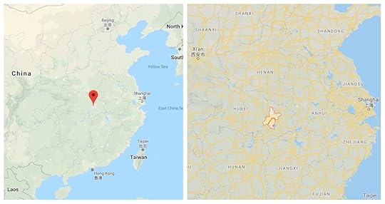
Photo: Google Maps
The coronavirus was first detected in the city of Wuhan, Hubei Province, China, at the end of December 2019. It is believed that the virus started from an animal source from the Wuhan live wildlife market and is currently being passed from human to human. The exact source of the 2019-nCoV is currently unknown.
How can one be infected by the new coronavirus?
Like many other respiratory illnesses, the new coronavirus is believed to be transmitted from human to human by respiratory droplets when one sneezes or coughs.
What are the symptoms of the new coronavirus?
Symptoms include fever, cough, and shortness of breath. The new coronavirus can cause pneumonia or bronchitis.
Is the new coronavirus dangerous?
The new coronavirus can cause severe pneumonia and bronchitis. People with cardiopulmonary disease, weakened immune systems, children, and elderly people are the most at risk.
Can the new coronavirus be treated?
Being a new virus, there is currently no treatment or vaccine against 2019-nCoV. The only thing medical professionals can currently do is alleviate the symptoms of the patients infected.
How to prevent being infected by the new coronavirus
The World Health Organization (WHO) and the Center for Disease Control and Prevention (CDC) recommend that you:
Wash your hands regularly with soap and water or an alcohol-based hand sanitizer
Cover your mouth when coughing or sneezing, and wash your hands afterward
Throw all used tissues away, and wash your hands after use
Do not touch your eyes, mouth, or nose with unwashed hands
Avoid contact with anyone who coughs, sneezes, or has a fever
To prevent others from getting infected:
Stay at home if you feel ill, and avoid contact with others
Thoroughly wash the objects and surfaces that you may have touched
Where is the new coronavirus now?
The following countries have identified cases of the new coronavirus:
China
Hong Kong
Macau
Taiwan
Australia
France
Japan
Malaysia
Nepal
Singapore
Thailand
The Republic of Korea
United States
Vietnam
Canada
How many people have been infected by, or died from, the new coronavirus?
As of January 27, the WHO reports 2,798 confirmed cases, 2,761 of which are in China, Taiwan, Hong Kong, and Macau. Of the 37 confirmed cases detected outside of China, 36 have traveled to China and 34 have travel history to Wuhan. The death toll currently amounts to 80. All of them have occurred in China.
What is being done to prevent the spread of the new coronavirus?
China announced that, as of Monday, January 27, 2020, it would suspend all group tours going abroad and the sale of flights and hotel packages.
As of January 23, 2020, nobody in the city of Wuhan is allowed to leave. Train stations and airports are closed. City buses, subways, ferries, and shuttle buses will not be operating until further notice. All other major cities in the Hubei province are on lockdown, and the whole province is quarantined from the rest of China. People entering are screened for coronavirus.
Chinese authorities have issued a ban on all wildlife trade. The source of the new coronavirus is allegedly linked to the live wildlife market in Wuhan.
In China, the Lunar New Year holiday has been prolonged to keep people at home. Schools are closed until further notice.
Travel in and out of the Chinese capital of Beijing by bus is limited.
Travelers coming from Wuhan into the US are being screened and tested for the 2019-nCoV at New York City’s John F. Kennedy International Airport, Los Angeles International Airport, San Francisco International Airport, Chicago O’Hare International Airport, and Hartsfield-Jackson Atlanta International Airport. The US plans to reroute all passengers coming from Wuhan to those five points of entry.
Mongolia has closed its border with China, and schools, universities, and playgrounds in the country are closed until March 2.
Taiwan has asked its citizens not to visit Central China.
North Korea is banning all foreign tourists from entering the country.
In Hong Kong, Lunar New Year celebrations have been canceled, schools are shut until mid-February. All trains and flights to Wuhan have been halted.
Hong Kong and Malaysia are denying entry to visitors coming from the Hubei province.
What travelers in or to China need to know
The US Department of State-Consular Affairs asks all travelers not to visit the Hubei Province. As of January 23, 2020, the whole of China has been issued a “Level 2: Exercise Increased Caution” travel advisory.
The CDC has advised travelers to avoid all non-essential travel to Hubei Province. The Forbidden City in Beijing and Shanghai Disneyland are closed to prevent the spread of the disease.
Travelers who have visited Hubei Province in the past 15 days and are experiencing symptoms of coronavirus are asked to avoid all contact with other people and to seek immediate medical help.
More like this: These are the travel vaccines you actually need, according to an expedition doctor
The post Everything travelers need to know about the coronavirus outbreak appeared first on Matador Network.

Gray wolf sightings in Colorado

Due to extermination programs, the population of gray wolves in the US was almost entirely gone by the 1940s, but for the first time in decades, the rare wolves have been spotted in the Colorado wilderness.
A press release by representatives of the Colorado Parks and Wildlife (CPW) department confirmed “the likely presence of multiple wolves in northwest Colorado,” due to the discovery of a scavenged elk carcass in Moffat County and nearby tracks. Together with an eyewitness report of six large wolves near the Wyoming and Utah border, these discoveries suggest that a pack of gray wolves is residing in northwest Colorado.
“The sighting marks the first time in recent history CPW has received a report of multiple wolves traveling together,” said @CPW_NW Regional Manager JT Romatzke. pic.twitter.com/kWphMzgWZ8
— CO Parks & Wildlife (@COParksWildlife) January 8, 2020
Wolf Update: Last Oct. an eyewitness reported seeing 6 large canids in the far NW corner of CO.
Last week’s discovery of a thoroughly scavenged bull elk carcass close to the sighting strongly suggests a pack of gray wolves may now be residing in Colorado.https://t.co/UEf2diEdd1
— CO Parks & Wildlife (@COParksWildlife) January 8, 2020
JT Romatzke, Northwest Region Manager, said in a statement, “We have no doubt that they are here, and the most recent sighting of what appears to be wolves traveling together in what can be best described as a pack is further evidence of the presence of wolves in Colorado.”
The timing of the sightings couldn’t be better as an initiative to reintroduce the gray wolf in the state of Colorado is on the ballot in Colorado for the 2020 general election. The wolves did not want to wait that long to make a comeback, it seems.
More like this: 10 endangered animals to see (and save) before they’re gone
The post Gray wolves were spotted in Colorado for the first time in 80 years appeared first on Matador Network.

Walk New Zealand’s Routeburn Track
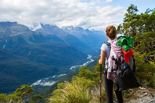
The Great Walks are hiking trails preserved by New Zealand’s Department of Conservation (DoC) that traverse some of the country’s most significant natural terrain. Winding through national parks, housing native wildlife, and hugging both sea and mountain, New Zealand’s 10 Great Walks are all multi-day adventures whisking hikers of all levels away into the wilderness.
As one of the shorter and more accessible of the Great Walks, the Routeburn Track is ideal for travelers with limited time or limited outdoor experience. I fell into this latter category when doing my working holiday in New Zealand, and Routeburn turned out to be a natural initiation to the backcountry. Bridging Mount Aspiring and Fiordland National Parks northwest of Queenstown on the South Island, this trail’s 20 miles take you through hanging valleys, glimmering streams, and soaring ranges.
Night 1: Routeburn Falls

Photo: Mellisa Pascale
My first day on Routeburn Track is April 25, Anzac Day. Anzac Day memorializes New Zealanders and Australians who died in war, and that morning, as the track shuttle stops over in Glenorchy, there’s a ceremony being held outside. The sole other passenger disembarks and joins the service, and I carry on to the beginning of the track at Routeburn Shelter.
I’m here at the very end of the Great Walks season, which lasts from October to the last day of April, which is autumn in New Zealand. Clouds take turns blocking the sun, though I hardly notice these antics as the track’s start has me shielded under tree cover. Before long, the level ground meets an incline, and I’m on my way to leaving the forest canopy behind for much of the trek. Around 1:00 PM, I find Routeburn Falls Hut overlooking a valley, the flats at the base of the mountains golden in the now freed sun. Altogether, it took three hours of walking, which is about what DoC estimates for this stretch of the trail.
How did I get here?
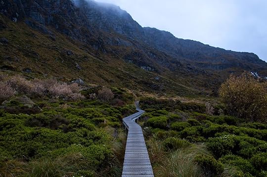
Photo: Mellisa Pascale
During the Great Walks season, all hikers are required to have hut or campsite tickets to stay overnight on the tracks. These can be booked online or in person at a DoC information center. I acquired my tickets two months in advance, and availability was already tight. Give yourself even more time than if you have a specific time frame in mind.
To begin the track at Routeburn Shelter, I spent the night before in Queenstown and booked a Tracknet shuttle to the trailhead. You can also start on the other side of the trail at The Divide, in which case you would probably catch a ride from Te Anau. You can choose from a number of shuttle services during the season; or, if you rent a car, you can also arrange to have someone move your vehicle for you so it’s waiting at the other end. Easyhike is one of the companies that provides this service.
Night 2: Lake Mackenzie

Photo: Mellisa Pascale
At 7:30 AM on my second day, I wave goodbye to Routeburn Falls and begin the ascent to Harris Saddle, the track’s 4,300-foot pinnacle. This is easily my favorite part of the whole trail. The overcast sky lends an air of snowglobe-esque comfort at Lake Harris, whose steel waters sit undisturbed in a hanging valley. Much of the terrain is blanketed in tussock grasses, evoking shades of rust and gold. I attempt a side trip to Conical Hill, but the heavy cloud cover doesn’t indicate I’ll see much from the top, so I turn around.
On the descent from Harris Saddle, a steady patter gathers on my hood and pack cover, and I think I can make out some snow-capped tops peering back at me from the other side of the veiled valley. I arrive at Lake Mackenzie Hut in the early afternoon, claim a bunk, and take a short side trip to nearby Split Rock. Back at the hut, a few trampers are submerging themselves in the lake waters, a task that seems crazy given the fact that this side of Harris Saddle is not only more overcast but also much more frigid. I dig to the bottom of my backpack to get to a book and settle in for a relaxing afternoon at Lake Mackenzie.
What’s in a hut?

Photo: Mellisa Pascale
I stayed in the huts on Routeburn Track, though the Great Walks also have campsites available. Outside the hut, you’ll find stacks of muddy boots waiting for their owners by the door. Nearby, toilets are fed by running water during the Great Walks season. Upon entering the hut, there will be a kitchen/living area with gas stoves, sinks, tables, and a fireplace, as well as a separate bunk room.
You’ll need to bring a lighter and cooking utensils to use the kitchen stoves, plus your own eating implements, washing supplies, and a trash bag to clean up and carry out. Some oddball items that won’t see much use off of the trail, like pots and pans or a sleeping bag, can be rented from companies in Queenstown or Te Anau. For a comprehensive packing list, this DoC checklist is helpful.
Night 3: Lake Howden

Photo: Mellisa Pascale
On the way to Lake Howden, the track passes close by Earland Falls, whose mist joins with the already dripping skies. Fortunately, the walk is much quicker than expected, and I’m out of the rain and at the next hut by mid-morning. Here, a few trampers who started from The Divide have already beaten me, everyone shivering. I pass the afternoon meeting an assortment of walkers: a couple linking up Routeburn Track with Caples Track, a grandmother and young grandson spending time together before he goes back to school, and a family who ingeniously hauled a whole pizza with them.
Every night, the DoC ranger on site gives a hut talk, going over track etiquette and answering questions. Tonight, the ranger gives us a heads up to look out for a pack of runners tomorrow morning. The annual Routeburn Classic, a race from The Divide to Routeburn Shelter, is set to take place. She divulges that the record time of completion is two hours and 37 minutes, making what will ultimately be my 13 hours of walking seem pretty unimpressive.
What’s next?

Photo: Mellisa Pascale
In the end, the Routeburn Classic gets postponed due to inclement weather. Actually, the track has been closed between Routeburn Falls Hut and Lake Mackenzie Hut due to heavy snowfall and avalanche risk, so I’m lucky that it’s my last day. When I leave Lake Howden Hut, slush is falling from the sky, but when I gain elevation walking up Key Summit, a side trail, I find inches of white powder on the ground. Harris Saddle must be practically buried.
I take a short loop around the top before descending to The Divide, where I stamp my cold feet in a shelter and wait for the shuttle to take me back to Queenstown. The Great Walks season ends in two days. I’m wary of attempting a full track outside of the season — when it’s recommended that only hikers who are expert in navigating the backcountry take part. I thus content myself with day walks on Kepler Track and other trails until the end of my days in New Zealand. And, of course, I can’t wait to go back and add a few more layers of Great Walk mud to my boots.
More like this: The Paparoa Track is New Zealand’s newest Great Walk, and it’s spectacular
The post New Zealand’s Routeburn Track is the perfect three-day Great Walk appeared first on Matador Network.

East Africa locust swarm

East Africa is currently experiencing its worst locust infestation in 25 years, threatening food security and livelihoods across an already vulnerable region, including Kenya, Somalia, and Ethiopia. South Sudan and Uganda are at risk but are currently not affected by the infestation.
The insects that come in swarms of millions are devastating crops and pastureland throughout the Horn of Africa. According to Jens Laerke, the spokesperson for the United Nations humanitarian office in Geneva, “A single locust can travel 150 kilometers and eat its own weight in food — about two grams — each day. A small swarm can consume the equivalent of food for 35,000 people in one day.”
The UN needs $70 million to support aerial pesticide spraying, the best way to contain this large infestation. If nothing is done, the United Nations warns that the swarms could grow 500 folds and continue until June.
According to the UN, spring desert locust infestations are also threatening the Red Sea region in Egypt, Sudan, Eritrea, Saudi Arabia, and Yemen.
More like this: 12 Swahili words to know before traveling in East Africa
The post Largest locust infestation in 25 years hits East Africa appeared first on Matador Network.

What to do in Tahoe besides ski

Most people who visit North Lake Tahoe in winter are planning to hit the slopes. After all, the region in California’s high Sierra hosted the 1960 Winter Olympic Games and is home to a dozen world-class ski areas all within 40 miles of one another. To go without at least attempting to ski or snowboard would appear to be selling your trip short. But if you, for whatever reason, are not there to slide downhill on a plank of some sort, there are plenty of other activities to keep you entertained, active, well-fed, and slaked on both booze and jaw-dropping lake views.
1. Start with a trip to the lake.

Photo: Faith Photography of Nevada/Shutterstock
The best way to access the lakeshore in winter is via the brand new East Shore Trail, a 2.8-mile paved path that gets partly snow- and ice-packed in winter, starting at Tunnel Creek Café in Incline Village. (The cafe makes delicious sandwiches you can take with you on the trek.) The trek follows the perimeter of the lake to Sand Harbor, offering you some of the most stunning views across the shimmering water, whether you’re traveling on foot, fat bike, or, depending on the snowpack, cross-country skis. Tahoe Dave’s has several locations in North Lake Tahoe and rents cross-country and snowshoe gear.
In the summer, you’ll see people pedaling along here with paddleboards and picnics in tow, but in winter, you could potentially have the entire trail to yourself — accessing pristine samples of shoreline such as Hidden Beach, free from the summertime sunbathers soaking up rays in the buff. After the hike, hit nearby Alibi Ale Works for well-honed suds and an amicable local’s vibe.
2. Admire the birdlife.

Photo: Written In Silver Visuals/Shutterstock
For those willing to work a little harder for their scenery, Chickadee Ridge is one of North Tahoe’s most unique spots for multi-sport recreation. It’s situated just 45 minutes from Reno, Nevada, near the Tahoe Meadows South Trailhead at the summit of the Mt. Rose Highway. The area is a hot spot for sledding, snowshoeing, cross-country skiing, or simply walking through the towering pines along the ridge in search of the friendly little birds. If you have birdseed to offer, the fluttering chickadees will eat right out of your hand — or off of your beanie. Also, the two-mile climb to the top of the ridge will reward you with a pine-framed view of the lake below.
3. Go fat-biking.

Photo: Peter Istvan/Shutterstock
Fat bikes are regular mountain bikes outfitted with extra large tires to handle challenging surfaces like sand or snow. Fat biking is exploding in ski towns across North America and Europe, as it’s an incredible workout and a more eco way to get around wintry landscapes. In addition to skiing, Tahoe Donner offers plenty of designated fat biking trails that you can access with a ticket from as early as 7:00 AM until as late as 5:00 PM; they have a limited number of fat bikes for rent, as well.
4. Join in the festive atmosphere.

Photo: Squaw Valley Alpine Meadows/Facebook
Sure, Squaw Valley Resort is known for its sprawling slopes, but skis or a snowboard are not an essential ingredient to reach the resort’s best views, or even get a little adrenaline rush. Anyone can take an aerial tram ride up to High Camp — although it does cost $49 for adults, it’s free if you have an IKON Pass. There, you get a bird’s-eye view of the cliff-laden ski area. Take in the whole scene over a stuffed Bloody Mary at Granite Bistro Café. In the spring, High Camp is home to dozens of half-clad soakers lounging in the giant hot tub to the soundtrack of a live DJ spinning on the deck.
The base of Squaw is also a great spot for tubing — not just sliding down a fast, snowy track on an inflatable apparatus but doing so amid lasers, lights, and more DJ tunes at what the resort has aptly dubbed Disco Tubing. Or you can just relax around one of the big fires with a pitcher of beer, a plate of nachos, and the afternoon sun. Not much beats the Squaw Valley afternoon scene — even if you apres-ski without the “ski” part.
5. Find some indoor entertainment.

Photo: ZikG/Shutterstock
When visiting High Camp, be sure to check out The Olympic Museum, displaying an assortment of one-of-a-kind artifacts, videos, and stories from the 1960 Games. If you’re a yogi, you’ve probably heard of the Wanderlust Festival, which was founded here in Squaw Valley. Squaw is also home to the flagship Wanderlust Yoga Studio, which offers a year-round schedule of just about every type of yoga class imaginable, including vinyasa, power, candle-lit, restorative, and even aerial.
Let’s not forget that the North Shore straddles the California and Nevada borders. Therefore, gambling is not hard to come by. The area’s hub for gaming is Crystal Bay, specifically, the Crystal Bay Casino, which, in addition to offering the standard slots and tables, also hosts a steady stream of A-list concerts and comedy acts.
6. Hang out in Truckee.

Photo: David A. Litman/Shutterstock
Truckee is an old mining town that grew up with the California Gold Rush 1849 and has kept its old-fashioned charm with its red-brick and wooden Old West interiors. Hang out with a good book and a cup of coffee at CoffeeBar. If you want a tasty wrap or a gluten free pastry with that coffee, you can’t go wrong at Wild Cherries. Truckee has some appealing gift shops like Bespoke, with its scarves and housewares. There are plenty of dinner options, among them Trokay, named for the native American who gave Truckee its name, with its cozy wooden interior and tempting, seasonally changing menu. A longtime favorite, Moody’s Bistro is also a good spot for live music.
7. Indulge in San Francisco’s foodie influence.

Photo: Christy Hill Lakeside Bistro/Facebook
The foodie culture from nearby San Francisco extends beyond Truckee, and North Lake Tahoe is home to myriad diverse dining haunts. A standout for seasonally fresh seafood, produce, and locally sourced meals is the cozy Sunnyside Restaurant. Situated in a log cabin lodge directly on the docks of the lake, it also offers the best sunset-on-the-lake views around, as documented in a recently published book (available at the restaurant) compiling the area’s top sunset photography. In Tahoe City, Christy Hill also offers incredible lake views and an unforgettable, locally sourced menu.
In Squaw Valley, Plumpjack Café, with its superbly mixed cocktails and homemade sourdough and butter wins for fine-dining. But Rocker offers an upscale pub experience with enormous salads and great beer selection while the newly opened Tremigo makes homemade salsa that you’ll want to down by the quart. For breakfast, try a freshly baked bagel at Wildflour Baking Company or an oozing benedict at Fire Sign Café.
More like this: The steep, staggering hikes you need to do in Palm Springs this winter
The post North Lake Tahoe is awesome in winter — even if you don’t ski appeared first on Matador Network.

Trump cuts protections for waterways

It sounds a bit counterintuitive for the Environmental Protection Agency to cut back on its protection of natural environments, but that’s exactly what it’s doing. The EPA is drastically reducing the number of US waterways and wetlands that will receive federal protection under the Clean Water Act — a decision opposed by even the agency’s own science advisors. Many business owners viewed the initial protections as an overreach of federal authority, as they made it difficult for farmers, builders, and mining companies to use the land as they wished.
According to EPA Administrator Andrew Wheeler, “All states have their own protections for waters within their borders, and many regulate more broadly than the federal government. Our new rule recognizes this relationship and strikes the proper balance between Washington, DC, and the states. And it clearly details which waters are subject to federal control under the Clean Water Act and, importantly, which waters fall solely under the states’ jurisdiction.”
The EPA’s own Science Advisory Board, however, opposes the rollback of protections. In a draft letter posted online, it said the rollback “decreases protection for our Nation’s waters and does not support the objective of restoring and maintaining ‘the chemical, physical and biological integrity’ of these waters.”
Trump has argued that the Obama-era protections “basically took your property away from [America’s farmers].” According to the New York Times, this is one of 95 environmental rules rolled back since Trump took office.
More like this: The greenest trips you can take to help the planet in 2020, according to experts
The post Trump administration cuts protections for US waterways and wetlands appeared first on Matador Network.

Matador Network's Blog

- Matador Network's profile
- 6 followers

