
Matador Network's Blog, page 67
February 18, 2025
The 10 Prettiest Places to Camp in the South
Return to the full list: the most scenic places to camp in the US
Camping in the South is an immersion into landscapes defined by dense forests, winding rivers, and humid, star-filled nights. It’s an experience where it feels like time stands still a little, with campgrounds tucked beside cypress swamps, beneath live oaks draped in Spanish moss, or along barrier islands shaped by both tide and time. The South’s relatively mild winters make it a year-round camping destination, but summer heat and humidity can be intense, especially in the Deep South.
The best camping in the South: seasonality and weather
Photo: Leigh Trail/Shutterstock
Camping in the southern US offers a diverse range of experiences, from the humid forests of the Southeast to dryer climates of Texas. Summer in much of the South brings intense heat and humidity, making camping challenging. If you’re planning a southern camping trip in July or August, you’ll want to look at higher elevations, or at least choose a site with strong coastal breezes.
Keep in mind, though, that mid-summer through mid-fall is also hurricane season along the coast, requiring careful monitoring of weather forecasts. That makes spring and fall the ideal camping seasons, though places like Florida are comfortable year-round.
Seasonality varies greatly across the region. In the Southeast, summer is marked by lush greenery and the constant hum of insects, while fall can bring bright red and orange foliage, especially around West Virginia and North Carolina. Around Texas, you’ll find more dramatic temperature fluctuations, with scorching days and surprisingly cold nights. If you’re near the beach, you’ll likely have warm days (or hot days, in the summer), but they’ll be tempered by coastal breezes at night.
Tips for beach camping in the South
Photo: Mariia Korneeva/Shutterstock
The southern states of the US offer some of the best places to camp directly on the beach, especially in Florida and Alabama along the Gulf of Mexico. But beach camping is a different beast. While the allure of falling asleep to the sound of crashing waves and waking to breathtaking sunrises is obvious, it’s not without its challenges. Sand can be a constant companion, infiltrating tents, gear, and even your food. It requires diligent shaking out and cleaning to avoid a gritty existence. And if you’re camping with a pet, get ready for the unpalatable combination of wet fur and heavy sand.
Weather is a major factor, too. Ocean breezes are refreshing after a hot day, but also mean you’ll need to stake down your tent or, if you can’t, have a method for otherwise securing items like tent flaps and umbrellas. Coastal areas are prone to sudden storms, and humidity can be high, making everything feel damp.
Perhaps the most notable challenge of beach camping, other than sand, are bugs. Mosquitoes, sand flies (also called “no-see-ums”), and other biting insects thrive in coastal environments, particularly at dawn and dusk. Be sure to pack insect repellent and consider using mosquito netting. If you’re hiking or walking around camp, you want tall socks to protect yourself from ticks, and if you’re camping with your dog, be sure to check them for ticks before they snuggle up in your tent for the night.
The best places to camp in the SouthThe list below highlights some of the best camping in the South, from the shores of the Atlantic Ocean to the dense bayous of the Florida Everglades and stunning desserts of Texas. While no single list could capture the incredible diversity of landscapes in the region, these sites represent some of the most unique and scenic places to pitch a tent.
Jump to:
Devils Fork State Park, SC | Garden Key, FL | North Prong Primitive Campground, TX | Edgar Evins State Park, TN | Jekyll Island State Park, GA | Stone Cliff Beach Campground, WV | Gulf State Park, AL | Red River Gorge Geological Area, KY | Seneca Shadows Campground, WV | Chickee Wilderness Camping, FL
Devils Fork State Park
Photo: The Dyrt/Camper Rachel G.
Location: Salem, South CarolinaCampground type: Car campingFacilities: DevelopedView: A mountain lake and healthy forestsDevils Fork State Park is a stunning place to camp for those who love crystal-clear mountain lakes and lush, forested shorelines. It sits on the bank of Lake Jocassee in South Carolina and has some of the most scenic waterfront camping in the region, particularly from the coveted tent sites along the lake’s edge (sites nine through 18). Those sites have direct views of Jocassee’s deep blue waters, framed by the rolling, misty peaks of the Blue Ridge Mountains in the distance. Sunrises turn the lake’s surface to gold, while evenings turn the water a soft shade of purple, with the occasional silhouette of a canoe gliding by. Reservations are required, though you may be able to snag a non-lakeshore site last minute. Read more at The Dyrt.
Garden Key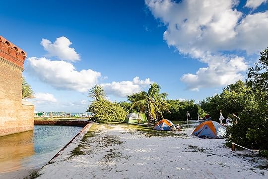
Photo: Sandra Foyt/Shutterstock
Location: Homestead, FloridaCampground type: Boat-in, then walk to sitesFacilities: PrimitiveView: Palm trees, a historic fort, and shallow lagoonsGarden Key Campground in Dry Tortugas National Park is one of the most remote and unforgettable places to camp in the South. It’s about 70 miles off the coast of Key West, sitting on a sandy island surrounded by turquoise waters, coral reefs, and historic Fort Jefferson. With no cars, no electricity, and only the sound of ocean waves, it’s a true escape into nature.
The only way to reach Garden Key is by ferry (which NPS advises reserving months in advance, if possible), and campers need to bring everything, including drinking water. But those willing to pack smart will be rewarded with some of the most breathtaking beachside camping imaginable, waking up to pink and gold sunrises over the Gulf of Mexico, snorkeling in crystal-clear waters full of tropical fish and sea turtles, and watching the sun set behind the fort’s massive brick walls. No reservations are accepted, and if all the sites are full, campers need to share the overflow camping area.
North Prong Primitive Campground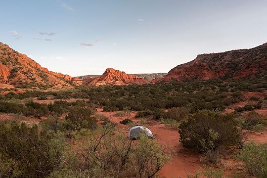
Photo: Joshua Lehew/Shutterstock
Location: Quitaque, TexasCampground type: Walk-inFacilities: PrimitiveView: Red-rock canyons and towering cliffsNorth Prong Primitive Campground in Caprock Canyons State Park offers eight secluded campsites in the middle of the park’s famous red-rock formations. Most tent sites have expansive views of canyons with flat clearings on vivid red dirt and are dotted with cottonwood trees and scrub oaks. The colors are vivid as can be at sunrise and sunset when light magnifies off steep red canyon walls in the distance. Reservations are suggested but not required – though with only eight sites, making one is highly advisable. You’ll need a backcountry reservation, though they’re just for access to the area, not for specific sites.
Edgar Evins State Park
Photo: Tennessee State Parks
Location: Silver Point, TennesseeCampground type: Car campingFacilities: DevelopedView: A treehouse perspective of golden sunsets and a shimmering lakeEdgar Evins State Park in Tennessee has a unique spin on lakeside camping, with 60 wooden platform campsites built into the slopes surrounding Center Hill Lake. The elevated platforms give campers a treehouse feel, especially since they’re surrounded by green oak and poplar trees. Those platforms mean you always have a level spot to pitch your tent, and that you’ll have stunning views of the lake and surrounding forested hills. It doesn’t hurt that the campground is only an hour from Nashville, or that the lake is one of the best destinations for catching the changing fall foliage of any place to camp in the South. Reservations are recommended.
Jekyll Island State Park
Photo: Joanne Dale/Shutterstock
Location: Jekyll Island, GeorgiaCampground type: Car campingFacilities: Full serviceView: Dreamy Spanish moss and endangered sea birdsJekyll Island Campground isn’t just a place to pitch a tent – it’s a front-row seat to one of Georgia’s most distinctive coastal landscapes. Unlike most beachfront campgrounds, this one is set back from the shore, but it’s a fair trade off: tent sites are spread under a canopy of ancient oak trees draped in Spanish moss, creating a setting that feels both secluded and deeply tied to the island’s history. Sites three to 11 sit in a bird sanctuary, and sites in the C Loop offer the best blend of privacy, quiet, and access to the tip of the island. Reservations are recommended.
Stone Cliff Beach Campground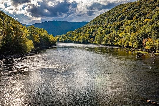
Photo: Gestalt Imagery/Shutterstock
Location: Thurmond, West VirginiaCampground type: Walk-inFacilities: PrimitiveView: The flowing New River and dense Appalachian forestsStone Cliff Beach Campground in New River Gorge National Park and Preserve is a small campground, with just seven sites. Five offer a serene riverside camping experience, with sites directly on the banks of the New River, while two sit higher back in the adjacent forest. That means campers have immediate access to the river for fishing, swimming, or relaxing in the sun. It’s a tent-only site, so you don’t need to worry about noise from RVs, and beach campers will have views of high cliffs, with a rugged and untamed feel that sets it apart from most other national parks. Campers don’t need to worry about reservations, and the site is first-come, first-served only. But don’t worry: New River Gorge National Park never really gets very crowded. Read more at The Dyrt.
Gulf State Park
Photo: Alabama Tourism
Location: Gulf Shores, AlabamaCampground type: Car campingFacilities: Full serviceView: Lakeside scenery, coastal wetlands, and seabirdsGulf State Park in Alabama offers some of the best coastal camping in the South, with stunning views of freshwater lakes, marshlands, and the Gulf of Mexico just a short walk away. The campground is dotted with towering pines and palmettos, with a mix of shaded sites and open spots with sweeping views of Middle Lake. For the best views, aim for sites along the waterfront, especially sites 11 to 9, or sites 469 to 496, which sit along a canal.
Lakeside campers here can count on incredible sunrise reflections over the water and are often visited by herons, osprey, and even the occasional alligator. One of the best parts of camping here is the quick access to the Gulf’s sugar-white sand beaches. Reservations are recommended.
Red River Gorge Geological Area
Photo: Michele Korfhage/Shutterstock
Location: Stanton, KentuckyCampground type: Walk in or car campingFacilities: PrimitiveView: Forested hills, rugged sandstone cliffs, and deep valleysNot to be confused with New River Gorge is Red River Gorge, a dream destination for backcountry campers who love dramatic rock formations and dense Appalachian forests. It sits in Daniel Boone National Forest in Kentucky, and is an intricate network of sandstone cliffs, natural arches, and towering rock walls that make it one of the most popular places to camp in the South. Backcountry sites are completely dispersed, meaning you can find your perfect spot anywhere you’d like, whether that means tucked beneath rock overhangs, on ridgelines with sweeping valley views, or in the quiet stillness of the forest floor. Princess Arch is a particularly popular spot. No reservations are needed. Read more at The Dyrt.
Seneca Shadows Campground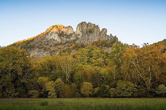
Photo: Karlsson Photo/Shutterstock
Location: Seneca Rocks, West VirginiaCampground type: Walk-inFacilities: DevelopedView: Stunning Scenic Rocks and fantastic fall foliageCamping at Seneca Shadows Campground is one of the best last-minute places to camp in the South, as most sites have excellent views of the iconic Seneca Rocks formation (though sites to the north may have the absolute best views). The campground is in Monongahela National Forest, surrounded by mountains to the east and west. For campers seeking the best views, opt for one of the walk-in sites. They’re in an open field with exceptional vistas, especially during sunset. Some sites are reservable on Recreation.gov, while others are first-come, first served.
Chickee Wilderness Camping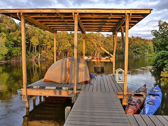
Photo: NPS/Jane Gamble
Location: Homestead, FloridaCampground type: Boat-inFacilities: PrimitiveView: Marshes, moss, ‘gators, shorebirds, and natural beautyEverglades National Park is an amazing place to camp if you love unique habitats, as the park is the largest mangrove system in the Western Hemisphere, and the park is home to more than 13 endangered species. The coolest way to stay in the park is definitely by pitching a tent on one of the park’s backcountry “chickees”: raised 10-foot-by-12-foot platforms above the marsh, where it’s too wet camp on the ground.
Most are paddle-in only, and, of course, you’ll need a freestanding tent. And you should have some basic waterway navigation experience, and rent a boat in advance. But campers willing to do that will be treated to one of the most unique camping experiences in the world, sleeping above the glassy, mangrove-tree-lined water and watching the ripples of wading birds, falling leaves, and even the occasional alligator sliding beneath the surface. Reservations are recommended, but last-minute spots may be available same day. 


The 10 Prettiest Places to Camp in the Midwestern US
Return to the full list: the most scenic places to camp in the US
Campsites in the Midwest don’t have the giant peaks of the Mountain West or the tropical views of a beach campground in Hawai’i, but that’s part of the appeal. The best places to camp in the Midwest highlight the beauty of the local landscapes, where campers can appreciate undeveloped, natural beauty: the sweep of prairie grasses under a vast sky, the quiet majesty of massive forests, and the shimmering expanse of the Great Lakes.
The Midwest may be the best place to find beach camping opportunities without other campers right next to your tent. Photo: Agnieszka Gaul/Shutterstock
Generally, compared to the iconic national parks of the Mountain West or the easier-to-reach parks of the East Coast, camping in the Midwest is often less competitive. You’re less likely to encounter the same level of crowds and probably won’t have to book sites months in advance (though you’ll still have do some planning).
Compared to camping in states farther west, you’ll find less backcountry camping in the Midwest — but still much more than on the East Coast. You can camp anywhere you like, within reason, in many midwestern national forests and state parks. However, those regions are sometimes smaller and less publicized than in the West, and require more research to discover. In general, backcountry experiences will be less about long-distance treks and more about shorter, more intimate experiences in the woods.
One way that the best places to camp in the Midwest truly shine is when it comes to finding space to yourself. Because campgrounds are often less crowded and sites are spread out, you’re more likely to find privacy. You can often find a quiet corner of the woods or a secluded spot by a lake where you can truly relax and enjoy the peace and quiet without seeing other campers for days. This feeling of spaciousness is a real highlight of the Midwest camping experience, and also means you’re more likely to have luck with last-minute and first-come, first-served campsites.
The 10 best places to camp in the MidwestIn partnership with our friends at The Dyrt, we’ve highlighted 10 places to camp in the Midwest that display the diverse beauty of the region. Lakes reign supreme in the Midwest, and there are plenty of places to pitch a tent on a site only accessible by kayak. But the Midwest also offers opportunities to find peaceful seclusion in the woods, or even camp overlooking massive plains filled with everything from herds of bison to migrating sandhill cranes.
Jump to:
Oak Island, WI | Presque Isle Rustic Campground, MI | The Wall, SD | North Manitou Island, MI | Fort Kearny State Recreation Area, NE | Lower Wisconsin Riverway, WI | South Bass Island State Park, OH | The Peninsula Trail, IN | Cottonwood Campground, ND | Frontcountry Camping in Voyageurs National Park, MN
Oak Island
Photo: NPS
Location: La Pointe, WisconsinCampground type: Boat-inFacilities: PrimitiveView: Lake Superior and other Apostles IslandsOf the 21 islands that comprise Wisconsin’s Apostles Island National Lakeshore, 18 allow camping. One is Oak Island, the highest point in the Apostles. Oak Island has five individual camp sites and two group sites spread around the coast on the south end, east side, and north end of the island. Sites two, three, and six have the best views of the water, though they’re all surrounded by lush, tall trees and have excellent access to the island’s hiking trails. Reservations are required for camping anywhere in Apostles Islands National Lakeshore, and you may want to reserve your transportation in advance, too. Either take the water taxi, or rent kayaks or canoes to paddle yourself.
Presque Isle Rustic Campground
Photo: UP Travel/Nathan Miller
Location: Ontonagon, MichiganCampground type: Car campingFacilities: BasicView: Great lakes and remote Yoop landscapesMichigan’s Upper Peninsula (The UP, or Yoop) is one of the prettiest parts of the Midwest, and Presque Isle Campground sits smack in the middle of one of the Yoop’s prettiest protected areas: Porcupine Mountains Wilderness State Park. Campsites are on Lake Superior’s shoreline and several have direct views of the river and surrounding old-growth forest. Sites 13, 15, and 17 sit closest to the water and are the most removed from the other campsites for the most privacy. Reservations are available, but not required.
Badlands Overlook (The Wall)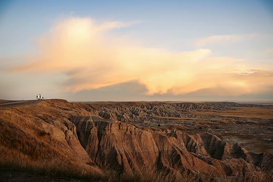
Photo: Aram Aghababian/Shutterstock
Location: Wall, South DakotaCampground type: Car campingFacilities: PrimitiveView: Rock formations and valleys around Badlands National Park“The Wall” is one of the most unofficial areas to camp in the Midwest on this list. Despite that, it’s well-known in South Dakota for being one of the most scenic. It sits about eight miles south of the town of Wall, and offers camping on cliffside pulloffs overlooking the sweeping expanses of the otherworldly landscapes of Badlands National Park. It’s on BLM land and has absolutely no facilities, so make sure you have everything you need. It’s popular with RVers, so you may encounter some vehicle noise if you’re in a tent in the area on busy weekends. As you’d expect, no reservations are available.
North Manitou Island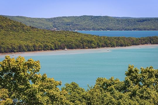
Photo: Zack Frank/Shutterstock
Location: Leland, MichiganCampground type: Boat-in, then walk to sitesFacilities: Both primitive and basic sitesView: Rolling dunes and islands on Lake MichiganNorth Manitou Island, in Sleeping Bear Dunes National Seashore, is the rare backcountry place to camp in the Midwest. The island allows dispersed camping, meaning campers can select their own secluded sites. Some of the most sought-after are those atop the sandy bluffs on the northwest side, as the elevated sites offer panoramic views of Lake Michigan’s turquoise waters (and provide stunning sunrises and sunsets). Campers who want easier access to the water should stay closer to Swenson’s Barn, on the west part of the island, and if you want a designated camping area head to the Village Campground. Reservations aren’t required, but you’ll need to get a backcountry permit at the Sleeping Bear Dunes ranger office before heading out. It also helps to reserve your spot on the ferry to the island in advance.
Fort Kearny State Recreation Area
Cranes near the Fort Kearney State Recreation Area campground. Photo: Visit Nebraska
Location: Gibbon, NebraskaCampground type: Car campingFacilities: DevelopedView: Thousands of snow-white cranesNebraska may not be the first place you’d think of for gorgeous camping — that is, unless you’re a birding enthusiast. From the campground in Fort Kearny State Recreation Area in Nebraska, campers can witness the annual sandhill crane migration that turns the nearby Platte River into a gathering point for thousands of sandhill cranes each spring. Tent sites are spread out under massive cottonwood trees, providing plenty of shade, and the marshy ponds around the site ensure you don’t have to walk far to see feathered friends. Reservations are available only between mid-April and mid-October; it’s first-come, first-served the rest of the year.
Lower Wisconsin Riverway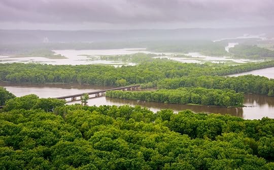
Photo: Zack Frank/Shutterstock
Location: Prairie du Sac, WisconsinCampground type: VariousFacilities: VariousView: Bald eagles, river bluffs, and epic sunsetsCamping along Wisconsin’s Lower Wisconsin State Riverway is a chance for campers to pitch their tents on the river’s numerous sandbars and islands. The natural clearings mean campers have unobstructed views of the surrounding waterway, plus wooded bluffs and scenic limestone and sandstone outcroppings. The sunsets are as pretty as you’d imagine, and birdlife, including bald eagles, are a common sight. Visitors can camp in designated areas like Tower Hill or Wyalusing state parks, or just choose whatever sandbar or island clearing strikes their fancy. Reservations are available for the official campgrounds. Read more at The Dyrt.
South Bass Island State Park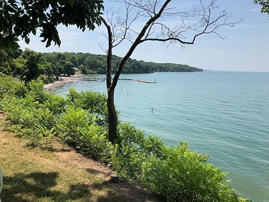
Photo: Alexander Serpen/Shutterstock
Location: Put-in-Bay, OhioCampground type: Boat-in (then walk to sites)Facilities: DevelopedView: Lake Erie and surrounding islandsCampsites on this island in Lake Erie are clearings on limestone cliffs on the southern edge of South Bass Island State Park. From the sites, campers have sweeping views of Lake Erie, and behind them, dense trees and park’s unique rock formations. The combination of dramatic cliffside settings and panoramic lake views makes camping here a picturesque experience. Reservations are required, and sites 100 to 135 are arguably the best, as they’re on the lake. You can also reserve your ferry tickets in advance (though you don’t need to), as reaching the sites involves taking a boat to the island, then walking to your site.
The Peninsula Trail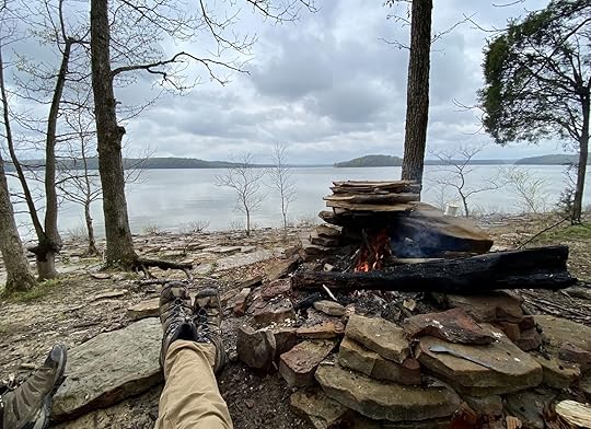
Photo: The Dyrt/Camper Steve D.
Location: Bloomington, IndianaCampground type: Walk-inFacilities: PrimitiveView: Hardwood forest and peaceful views of Lake MonroeThe Peninsula Trail begins in Charles C. Deam Wilderness in Hosier National Forest, about two hours south of Indianapolis. It’s a wildly popular place to camp, and with just about a dozen designated camp areas on the peninsula itself, there’s no guarantee that you’ll find a spot. But if you do, you’ll be treated to a sense of seclusion on the wooded landmass jutting into Monroe Lake. The established campsites are tucked into the trees under rich green foliage, with views of the sparkling lake peaking through the trees. But if they’re taken, you can still camp nearby, provided you follow the posted rules, such as not camping within 100 feet of the water line, among others. Read more at The Dyrt.
Cottonwood Campground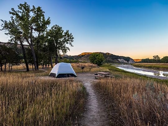
Photo: Randy Runtsch/Shutterstock
Location: Medora, North DakotaCampground type: Car campingFacilities: BasicView: Sprawling badlands and roaming bisonCottonwood Campground in Theodore Roosevelt National Park isn’t about plush amenities — it’s about complete immersion in the North Dakota badlands. The views from the campsites look out onto a landscape sculpted by time and erosion. Campers are surrounded by layered rock formations rising in fantastical, almost alien-like shapes, sweeping panoramas of the badlands, and even the occasional herd of roaming bison. (Give them plenty of space, obviously.) Be sure to look carefully at the images of campsites on the reservations page, as some have partial foliage while others are entirely exposed to sun and wind. Half the sites are available to reserve in advance, while the other are first-come, first-served.
Frontcountry Camping in Voyageurs National Park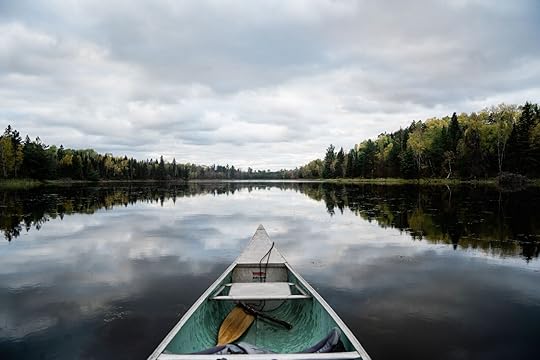
Photo: Alexanderschmitt1998/Shutterstock
Location: MinnesotaCampground type: Boat-inFacilities: PrimitiveView: Northwoods wilderness, glassy bays, and quiet covesFrontcountry camping on Rainy Lake is about being surrounded by water, sky, and the untamed beauty of Voyageurs National Park. Frontcountry camping sites are boat-in only, and the sites along Rainy Lake offer some of the easiest paddles. All campsites are on the shoreline, though some are beneath towering pines while others are more open to the sun and wind. From just about every campsite, you’ll look out over the vast, island-dotted expanse of Rainy Lake, where dense boreal forest ends at rocky shorelines that give way to shimmering blue water. Reservations are required for both campsites and boat rentals (which can’t be rented through the park), so be sure to read all the details on Recreation.gov before making your plans. Note that the park also has a few hike-in sites that don’t require boat access, as well the ability for unique lakeside camping on houseboats.
February 17, 2025
The 8 Best River Cruises for Food and Wine Lovers
It would be too easy to write off river cruises as sedate affairs. They often move at a slower pace even than big ship ocean cruises, and lack the flashy big ship amenities. Yet that is actually part of the draw. River cruise ships are always small with an intimate guest-to-crew ratio, and there are never tacky giant slides, bumper cars, or pools that take up much of the deck (the ocean my not have size restrictions, but rivers certainly do). This allows the focus to be elsewhere. And for some of the best of the best, that focus is on food.
From the gastronomic delights of Western and Central Europe to the specialties of South America and Southeast Asia, these are the best food and wine-centric river cruises you can take in 2025 and 2026.
Grand gastronomic cruise on The Rhine with CroisiEurope
Photo: CroisiEurope
When: November 15-18, 2025Where: The Rhine River, departing and concluding in Strasbourg, FranceShip and capacity: MS Symphonie, up to 107 guestsStarting price: From $1,389This four-day, three-night sailing along the Rhine River makes two stops along the round-trip Strasbourg route: one in Shoeneau, France, and one in Breisach, Germany. When in Breisach, guests will have the opportunity to take a coach ride along Alsace’s famous wine trail, going through picturesque small towns and stopping for tastings at wine cellars.
Passengers on board MS Symphonie will not only be served refined French cuisine prepared by the ship’s skilled cooks throughout the voyage, they will also have the opportunity to enjoy a dinner crafted by Marc Haeberlin, the head chef at the two-Michelin-star Alsatian restaurant L’Auberge de l’ill à Illhaeusern. Another Alsatia expert with lead wine tastings onboard: sommelier Serge Dubs, awarded with the titles of France’s best sommelier in 1983, Europe’s best sommelier in 1988, and world’s best sommelier in 1989.
Learn MoreCooking classes and Peruvian specialties on the Amazon River with Delfin Amazon Cruises
Photos: Delnfin Amazon Cruises
When: Multiple dates through 2025 and 2026Where: The Amazon River around the Pacaya Samiria National Reserve in PeruShip and capacity: Delfin III, up to 44 guestsStarting price: From $3,800Travelers who choose to take an Amazon River cruise usually do so for the immersion in nature and wildlife sightings, not for the culinary experience. But with Delfin Amazon Cruises, they can have it all. Delfin Amazon Cruises is one of only three cruise lines in the world with the highly coveted Relais & Châteaux label, a guarantee of excellent service and remarkable cuisine.
Onboard Delfin III, Peruvian Amazon chef Isaac Saavedra serves regional dishes using ingredients from the surrounding rainforest and the cruise line’s own garden near the town of Iquitos. Local ingredients include fruits like cocona and taperiba, peppers like charapita and motelillo, and paiche (the largest fish in the world). Saavedra does more than prepare meals, he also gives hand-on cooking demonstrations to teach guests how to make traditional dishes like ceviche and patarashca (fish and vegetables in banana leaves).
Learn MoreA food-and-drink cruise along Portugal’s Douro River with Viking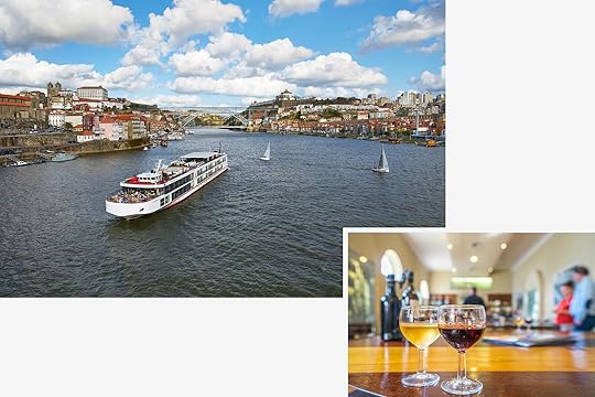
Photos: Viking
When: Multiple dates throughout 2025 and 2026Where: The Duoro River, departing and concluding in LisbonShip and capacity: Viking’s small modern longships, up to 106 guestsStarting price: From $4,199This 10-day trip starts with two days on land in Lisbon for a 3.5-hour food tour complete with tastings of cheese, smoked sausage, and pastel de nata (a Portuguese egg custard pastry). Embarkation takes place on the third day in Porto, where the famous port wine comes from. While there, you’ll have the opportunity to visit W. & J. Graham’s, a family-run winery that’s been operating since 1820, to take part in a port tasting and a traditional Portuguese meal.
The Douro Valley the river flows through is filled with wine estates, including Mateus Palace, which you will have the chance to tour extensively before enjoying a tasting. At Quinta da Avessada, another wine estate on the Douro, you’ll be able to take a tour, participate in the harvest, and sample wines. And because you can’t function on wine alone, in the nearby village of Favaios there’s a traditional baking demonstration and a chance to try the local bread.
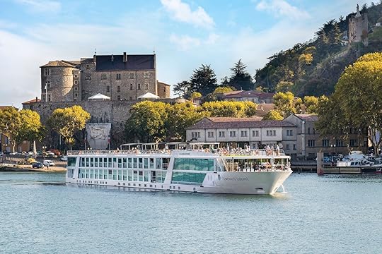
Learn MoreCulinary cruise on The Rhône River with Emerald Cruises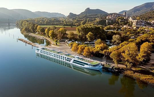
Photo: Emerald Cruises
When: Multiple dates in 2025Where: The Rhône River, either southbound from Lyon to Arles, or northbound from Arles to LyonShip and capacity: Emerald Liberté, up to 138 guestsStarting price: From $4,008This seven-night, eight-day cruise along the Rhône River is all about food and wine. Besides the delectable dinners, complimentary wine and beer, and cheese and olive tastings onboard the ship, guests will have the chance to experience the famous wine and cuisine of Burgundy and Provence on land. Excursions include a culinary tour of Lyon (the center of French gastronomy), hikes among vineyards in Tournon, and wine tasting in Châteauneuf-du-Pape, one of the most famous wine towns in the country. The icing on the cake of this culinary cruise, however, is the Provençal dinner hosted by local chef Fabien Morreale, who is famous for his elegant regional cuisine and for being a final contestant in the French version of Top Chef in 2013.
Learn MoreRum distillery tastings and street food along the Mekong River with Scenic River Cruises
Photos: Scenic River Cruises
When: Multiple dates in 2025Where: The Mekong River, from Siam Reap in Cambodia to Ho Chi Minh City in VietnamShip and capacity: Scenic Spirit, up to 68 guestsStarting price: From $10,670Wherever you decide to go with the ultra-luxury river cruise line Scenic Cruises, you’re guaranteed to eat very well. Each ship has multiple dining options — some involving 10-course meals — and Champagne breakfast is a daily staple. But Scenic’s Treasures of the Mekong sailing, which goes through both Cambodia and Vietnam, takes the food experiences up a notch. Vietnamese and Cambodian cuisine are served in the main restaurant throughout the sailing. Also, you can expect street food tours on either a scooter or a jeep, depending on your preference; a gala-themed dinner at an ancient temple; market visits (including a floating market); as well as dinners and afternoon teas in renowned establishments. You can even try your hand at making Cambodian cuisine with the chef in the ship’s kitchen after shopping for ingredients at the local market.
Learn MoreA culinary experience in grand France with Avalon Waterways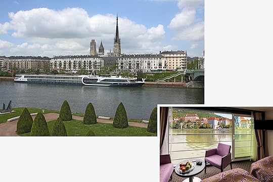
Photos: Avalon Waterways
When: March 31 to April 14, 2026Where: Three rivers covering Arles in the Provence region, through Burgundy and Paris, and up to NormandyShip and capacity: Avalon Poetry II and Avalon Tapestry II, 128 guestsStarting price: From $9,524This 15-day cruise sails on three rivers: The Rhône River from the city of Arles in southern France to Lyon in Burgundy, the Saône River from Lyon to Chalons-sur-Soâne, and the Seine River from Paris to Rouen in Normandy. And while the captain is busy navigating these rivers, you’ll be treated to a cheese tasting, a pastry-making demonstration, crepe lunches, a gourmet dinner in the tradition of famous French chef Paul Bocuse, and the guidance of a certified sommelier for all your meals. On land, you’ll take part in regional food tastings in the town of Vivier, a food tour in Lyon, a wine tasting in the cellar of a medieval castle in Chalons-sur-Soâne, and a Calvados tasting at a local distillery in Normandy.
Learn MoreWine tastings and farmers’ market visits in Bordeaux with Uniworld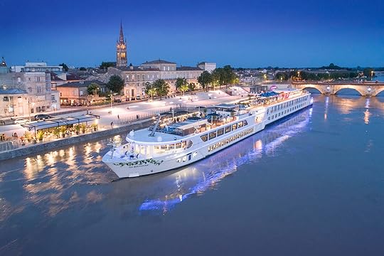
Photo: Uniworld
When: Multiple dates throughout 2025 and 2026Where: The Garonne and Dordogne Rivers, departing from and concluding in BordeauxShip and capacity: S.S. Bon Voyage, 124 guestsStarting price: From $3,569There’s perhaps no better place to combine excellent food with fine wine than Bordeaux, so Uniworld has designed an eight-day itinerary in the region for all the epicureans in need of a vacation. During the sailing on both the Garonne and the Dordogne Rivers, guests onboard the S.S. Bon Voyage will have the opportunity to tour multiple vineyards on foot and by bike, take part in wine tastings in wine estates and wine bars (including desert wines and grands crus), and try out Cognacs. Of course, food is also on the menu, with an oyster tasting led by an oyster farmer and a traditional French picnic lunch on the grounds of a castle.
Learn MoreA food and wine cruise along the Columbia and Snake Rivers with National Geographic-Lindblad Expeditions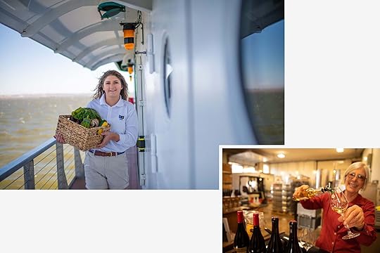
Photo: Lindbald Expeditions
When: Multiple dates in 2025 for eight-day or six-day sailingsWhere: The Colombia and Snake Rivers, either eastbound from Portland, Oregon, to Clarkston, Washington, or westbound from Clarkston to PortlandShip and capacity: National Geographic Sea Lion and National Geographic Sea Bird, up to 62 guestsStarting price: From $3,665National Geographic-Lindblad Expeditions collaborates with Food & Wine magazine to offer a river cruises that mix outdoor activities with culinary indulgence. In between hikes, kayaking sessions, and Zodiac tours, you’ll partake in nightly tastings of regional wines, visit wineries, meet local winemakers, and eat meals prepared with ingredients sourced from the surrounding Pacific Northwest region. In Astoria, you’ll be served beer and oysters provided by local business Buoy Beer Company, and you’ll try local specialties in other stops along the voyage, including Palouse Falls and Walla Walla.
February 14, 2025
How to Plan a Stress-Free Trip to France: A Guide for Your First Big Trip

There’s no city in the world that has the allure of Paris. For centuries, the City of Light has drawn visitors from near and far, all eager to explore the rich history, iconic landmarks, world-class cuisine, and, of course, its penchant for romance. Or, simply, to sit for hours at a cafe like an artistic bohemian expat in Ernest Hemingway’s “The Sun Also Rises.” The French Riviera, stretching the length of the country’s Mediterranean coastline, is no less romantic nor lacking in vibrant cultural offerings.
Bringing the two destinations together is a dream trip for travelers the world over. But without some inside intel, it can be hard (not to mention time consuming) to make that dream trip a reality. With the help of Acqua Travel’s Paris and French Riviera tour, going on the perfect trip to France can be stress-free.
The best way to see Paris and the French Riviera
Photos: Adisa/Shutterstock and Pani Garmyder/Shutterstock
The last thing you want when planning a big international trip is to realize you’ve forgotten a crucial detail just before leaving. Sometimes email just likes to make it hard to find that train ticket or hotel reservation you swore you made. Booking the Paris and French Riviera tour with Acqua Travel ensures a smooth and stress-free experience due to the company’s meticulous knowledge of travel through France and the fact that you’ll have a dedicated agent handling all of the bookings for you.
The tour offers a comprehensive itinerary that includes iconic landmarks — including the Eiffel Tower, the Louvre, and Notre-Dame Cathedral in Paris — as well as the charming coastal towns of the French Riviera. Acqua Travel’s local specialists collaborate with you to customize the journey, ensuring your preferences are prioritized. This personalized approach allows you to immerse yourself in the rich history, artistic treasures, and timeless beauty of France without the hassle of organizing logistics.

Photo: f11photo/Shutterstock
The coolest thing about the Paris and French Riviera tour is that, unlike many tour operators, everything from the dates of your trip to specific stops along the way are customizable. It’s not a staunchy, pre-packaged jaunt, but a trip built around seeing the best of these incredible locales on your terms. In effect, you’re getting the freedom of executing a trip your own way, without having to stress about putting it all together.
This means adding in the cultural sights, museums, and landmarks that top your list, and ensuring a reservation at that restaurant a friend back home raved about (you don’t want to miss Sacrée Fleur, of course). After finalizing your itinerary, Acqua Travel handles all the logistics, including bookings and confirmations, providing you with detailed travel documents and 24/7 customer support in the weeks leading up to your trip. All you need to do is prepare to enjoy the journey – and, of course, do a bit of hands-on research about regional wines before heading out.
What to watch out for and know in advance when traveling to France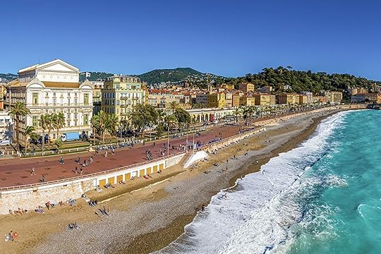
Photo: Alexey Fedorenko/Shutterstock
When traveling to France, it’s important to be aware of cultural norms and etiquette. The French value politeness, so always greet shopkeepers, waitstaff, or anyone you interact with by saying a simple bonjour (good day) or bonsoir (good evening) along with ça va (how are you). Likewise, addressing people with monsieur or madame is a sign of respect. While many people in major cities like Paris speak English, making an effort to use basic French phrases can go a long way in creating positive interactions.
Restaurant culture in France differs from some other countries. Waiters do not check on diners frequently, and service can be more relaxed, so patience is key. Tipping is not obligatory, as a service charge is often included in the bill, but leaving small change is customary for exceptional service.
France has an excellent public transportation system, with efficient trains, metros, and buses. Pickpocketing can be an issue, but touring with a local expert significantly reduces the risk. You may choose to keep valuables secure using crossbody bags with zippers while on the go, but lodgings secured by Acqua Travel feature safes and on-site staff to prevent any issues.
Many stores and restaurants close for a few hours in the afternoon, especially in smaller towns, so planning ahead is essential. If visiting during peak tourist seasons, purchasing tickets for major attractions in advance can save time and avoid long queues. Finally, France has strict rules regarding driving and speed limits, including the requirement for an international driver’s permit for non-EU visitors.
Notably, though, Paris and the French Riviera are accustomed to travelers and have excellent infrastructure to support them.
How booking with Acqua Travel ensures the smoothest experience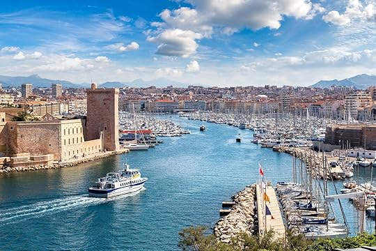
Photo: Sergii Figurnyi/Shutterstock
One major benefit of booking with Acqua Travel is that most major concerns regarding traveling internationally won’t be an issue. You won’t have to drive, and therefore won’t need the international driver’s permit or have to navigate those famously tight European roads. Also, all of your tickets and entrance fees will be taken care of in advance, so there’s no worry of long lines or sold out attractions.
You’ll always be accompanied by knowledgeable local experts who are familiar with the safest routes, areas to avoid, and how to navigate busy tourist spots. In case of emergency, you have direct access to 24/7 support, ensuring you’ll never be left to navigate challenging situations alone. Largely, everything is taken care of in advance.
I’m interested. What’s included in the tour?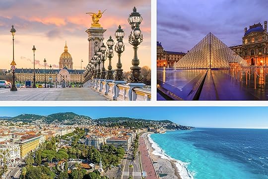
Photos: f11photo/Shutterstock, huntergol hp/Shutterstock, and Alexey Fedorenko/Shutterstock
The Paris and French Riviera tour with Acqua Travel includes visits to Paris, Marseille, and Nice. The tour of the “enchanting beauty and culture of France” begins in Paris with a night tour in a classic Citroën 2CV, a hop-on-hop-off city tour, and visits to landmarks like the Eiffel Tower. The tour proceeds to the Palace of Versailles, then travels to Marseille for a historical city tour, continuing to Nice on the French Riviera with tours to Monaco, Monte-Carlo, Eze, Cannes, Antibes, and St. Paul De Vence.
The kicker is that booking through Acqua Travel includes entrance fees to the sights you’ll visit, along with English-speaking local guides as applicable. Hotel and airport transfers are taken care of, as is breakfast each morning. Some lunches and dinners are set in advance and covered, others you’ll have the chance to choose and explore on your own (be sure to make at least one impulse cafe decision).
The Paris and French Riviera tour highlights include:
The enchanting streets of Paris. You’ll head to the second level of the Eiffel Tower to take in Notre Dame, the Arc de Triomphe, and the Champs Élysées, and enjoy a one-cruise on the Seine River (A swim in the Seine with Mayor Anne Hidalgo not guaranteed, however).Marseille, a bustling port city known for its vibrant culture and stunning Mediterranean views.Nice, where the azure waters of the French Riviera line charming Old Town streets (and the beaches are absolutely beautiful).More like thisArt + ArchitectureThis 19th-Century Train Station Is the Second-Most Visited Museum in Paris
After the Fires, LA Will Rebuild. Travelers Can Volunteer to Help

The recent Los Angeles wildfires have left widespread devastation in their wake, destroying homes, businesses, and vast stretches of land. Thousands of residents have been displaced, with entire communities reduced to ash and critical infrastructure severely damaged. The environmental toll is equally severe, with wildlife habitats lost and both water sources and air quality compromised. Now, more than ever, affected families and businesses need support to rebuild their lives. Emergency aid, housing assistance, and long-term recovery efforts are essential to restoring these communities. Donations, volunteer efforts, and government aid will play a crucial role in helping survivors recover and rebuild stronger, more resilient homes and infrastructure. Habitat for Humanity of Greater Los Angeles is a leading player in coordinating volunteer efforts in the area and working to rebuild via its ReBUILD LA initiative. If you’re planning a trip to Los Angeles, you can help – even if you have only a few hours to give. Matador spoke with Erin Rank, CEO of the organization, about current needs and how to get involved.
An overview of the current need for volunteer help in Los Angeles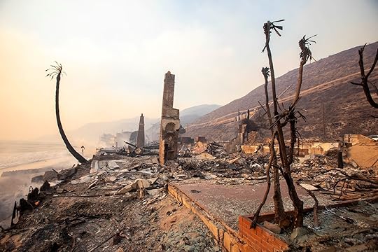
Photo: Arprince/Shutterstock
Volunteer efforts to support Los Angeles communities affected by the January 2025 wildfires commenced almost immediately after the fires ignited in early January. Local residents, organizations, and even celebrities mobilized to provide aid. For instance, chef Daniel Shemtob, despite losing his own home, partnered with World Central Kitchen to prepare meals for those affected and first responders. Community hubs like All Power Books transformed into emergency supply centers, coordinating volunteer efforts to deliver resources to survivors and frontline workers, according to a report in The Guardian.
As of mid-February 2025, significant progress has been made in relief and rebuilding efforts. Benefit events, such as the FireAid concert on January 30, 2025, raised substantial funds to support those affected by the fires. Additionally, organizations like the Los Angeles Regional Food Bank have distributed thousands of food packages to displaced families, with the help of over a thousand volunteers. However, the road to full recovery is ongoing, and continued support remains essential to rebuild and restore the affected communities.
“The need for rebuilding efforts is urgent,” Rank told Matador via email. “Entire communities have been displaced, and many families have lost everything. Our focus is on providing safe, stable housing for those impacted, whether through rebuilding homes, assisting with critical repairs, or supporting families in need of temporary shelter solutions.”
How travelers can get involved while in the area
Photo: Elliott Cowand Jr./Shutterstock
Rebuilding after the wildfires will be a tremendous ongoing effort over the next several years. This means that if you have plans to visit Los Angeles at any point in 2025, there will likely be on-the-ground help needed, even if you only have a small amount of time to give.
“In the coming weeks, we need volunteers to assist with wildfire recovery efforts, including distribution events, home repairs, and rebuilding projects,” Rank says. “Skilled volunteers such as carpenters, electricians, and general contractors are needed, but there are also plenty of opportunities for those without construction experience.”
Travelers visiting the area can sign up in advance to be notified of current and ongoing volunteer needs via a dedicated form. Rank notes that those without construction experience can help with donation sorting, supply distribution, and community outreach to connect affected families with vital resources.
“Every helping hand makes a difference in getting families back on their feet,” Rank says.
The group LA Works also posts volunteer opportunities that are readily available. For those unable to donate time, Habitat for Humanity of Greater Los Angeles is accepting donations to help fund its wildfire rebuilding efforts via a Fundraise page.
Why rebuilding after the LA wildfires will be such a challenge
Photo: eley archive/Shutterstock
Rank notes that wildfires create specific challenges beyond the immediate destruction. In this case entire neighborhoods were destroyed, displacing communities of people and leaving them in some cases with nothing left.
“The toxic debris and air quality issues also make cleanup and rebuilding more complex and hazardous,” Rank says.
Another major factor facing the Los Angeles area is the ongoing housing crises, already at height even before the fires. As many of the damaged neighborhoods are in wealthier enclaves, the displaced families are likely to drive up rent prices even further, making finding a home more difficult for those less fortunate.
“Additionally, in California, the ongoing housing crisis means that finding temporary shelter for displaced families is especially difficult,” Rank says. “The scale of rebuilding is enormous, and long-term solutions are critical to ensuring these families don’t just recover but thrive.”
Despite the rough road ahead, Rank and Habitat for Humanity of Greater Los Angeles remain positive that the city can and will rebuild, resulting in neighborhoods more resilient than they were before.
“People should know that recovery will take time, and sustained support is crucial,” Rank says. “Whether through volunteering, donating, or spreading awareness, every action helps ensure that families can return home stronger than before.”
February 13, 2025
In-Flight Fire Risk: Airline Bans Portable Phone Chargers in Overhead Bins

In the US, portable power banks, backup chargers, and any type of lithium batteries have been banned from checked bags for several years. According to the Federal Aviation Administration (FAA), “Power Banks, cell phone battery charging cases, rechargeable and non-rechargeable lithium batteries, cell phone batteries, laptop batteries, power banks, external batteries, [and] portable rechargers must be in carry-on bags, as they can cause “thermal runaway” when packed in check bags — meaning they could start fires in the luggage hold. Though it may sound unlikely, the FAA database has more than 500 recorded incidents of smoke or heat from batteries in checked bags since 2006.
But one international airline is taking it a step further, telling customers not only can they not check portable power banks — they can’t even put them in the overhead bins.

Any portable or back-up chargers now need to be in your personal item under the seat on Busan Air. Photo: Skrypnykov Dmytro/Shutterstock
Air Busan is a small-but-growing low-cost airline based in South Korea, and it announced in early February 2025 that lithium batteries must be stored in sight of travelers. Flyers need to carry them in the bags they store under the seats in front of them, not in the overhead bins. The idea is that passengers will be able to keep a closer eye on those items, and notice sooner any heat- or smoke-related issues.The news was first reported by Reuters and comes in response to a January 28 incident in which an Air Busan airplane caught fire while preparing to depart Gimhae International Airport. (All 166 on board were safely evacuated.) Though the cause of the fire has yet to be determined, an Air Busan source told reporters that the fire was first noticed by a flight attendant, who saw smoke coming from an overhead bin.
View this post on Instagram
A post shared by Al Jazeera English (@aljazeeraenglish)
The change is expected to go into effect on March 1, 2025. Passengers will have their bags searched before boarding, and only bags without lithium batteries will be marked with a safe tag, and allowed to be stored in overhead bins. The airline stated that trials of the program will start in Busan, South Korea, before it becomes a company-wide policy. As of now, no other airlines have publicly announced plans to implement similar restrictions on power banks in overhead bins. However, most US airlines do announce before takeoff that passengers should tell the flight attendants if their phone falls between seats, as this can cause thermal runaway.
So far in 2025, there have been three confirmed issues of thermal runaway in US airspace. They include a January 2 incident in which a Honolulu-bound passenger accidentally activated two vape pens in flight, and incidents on January 8 and January 15 in which passengers’ cell phones went into thermal runaway. In all instances, flight attendants were able to put the devices in on-board thermal containment bags, and the flights continued without incident.
The Most Gorgeous in Roma Norte Airbnbs, Mexico City’s Artsiest Neighborhood

Roma is, along with La Condesa, one of the centers of the hipster culture in Mexico City. It hosts many Art-Nouveau and Neo-Classical architectural gems, which gives it a European feel, and it’s now home to trendy restaurants, cafes, and shops. The area of Roma-Condesa was designated as a barrio mágico (“magical neighborhood”) by the city in 2011. Along with Polanco, it’s among the most popular barrios for visitors in the city. Here are the best Roma Airbnbs in the heart of Mexico City.
We hope you love the Roma Airbnbs we recommend! Just so you know, Matador may collect a small commission from the links on this page if you decide to book a stay. Listed prices are accurate as of the time of publication.
Lovely apartment with a terrace in a building with private security
Taking a trip to Mexico? Check out Matador’s Mexico accommodations guides: The best Airbnbs in and around Mexico City’s historic center 8 La Condesa Airbnbs to settle into Mexico City’s coolest neighborhood 8 stunning Polanco Airbnbs in the city’s most international neighborhood Grab Your Crew and Book These Oaxaca and CDMX Airbnbs for Dia de Los Muertos These Top-Rated Tulum Airbnb Rentals Put You Right Near the Beach 11 Cancún Airbnbs for an Unforgettable Beach Vacation 11 Airbnbs In Cabo San Lucas for a Perfect Beach Escape 11 Airbnbs in Sayulita to experience Mexico’s most underrated beach town These Airbnbs in Tijuana showcase the best of Mexico’s underrated coastal city
 Photo: Airbnb
 Photo: Airbnb
 Photo: Airbnb
See more photos
This gorgeous unit epitomizes the culture of Roma. It’s clean and modern, but uniquely could not be anywhere else but this neighborhood, at this time. It’s good for remote work and for patio happy hours. It also offers easy cafe access. Centrally located and tastefully decorated and designed, all the guests agree: this apartment is beautiful.
Three guests, one-bedroom
Price: $114 per night
 Photo: Airbnb
 Photo: Airbnb
 Photo: Airbnb
 Photo: Airbnb
See more photos
This apartment is exceptionally well located, it has a super fun layout, it’s very safe and cutely decorated. The unit features an upstairs and downstairs area with sleeping quarters, and is bright enough to spur even non-morning persons into action for a day out in Mexico City. Of all Roma Airbnbs, this one is perhaps the most well-lit and inspiring.
Four guests, two bedrooms
Price: $68
 Photo: Airbnb
 Photo: Airbnb
 Photo: Airbnb
 Photo: Airbnb
See more photos
The location of this oasis apartment is perfect: away enough from restaurants and bars but within a short walking distance to everywhere. The apartment is at the top of the building and the rounded-shaped windows, the high ceilings, and the views create a general ambiance of peace and calmness. Be aware that there is a spiral staircase to get up to the apartment. There are bunk beds in one of the bedrooms that are great for kids or friends who don’t mind sharing a room. The master bedroom is traditional and open.
Four guests, two bedrooms
Price: $111 per night
 Photo: Airbnb
 Photo: Airbnb
 Photo: Airbnb
See more photos
This seductive apartment is located on a tree-lined street overlooking the beautiful and lush Rio de Janeiro park, one of the highlights of la Roma Norte. The terrace is full of flowers, butterflies, and hummingbirds, and some of the adjectives former guests have used to describe it are “magnificent,” “magical,” and “a gem.” The kitchen is tight but you’re here to experience the city’s food culture anyway — and there are plenty of restaurants and coffee shops in this area.
Two guests, one bedroom
Price: $198 per night
 Photo: Airbnb
 Photo: Airbnb
 Photo: Airbnb
 Photo: Airbnb
See more photos
A very clean, carefully equipped apartment with tons of natural light and close to everything. Walk to cafes and taco shops, and everything from Chapultepec Park to Centro is a quick Uber ride. The unit allows you to take in the city from multiple angles, making for great sunrises and great sunsets. One former guest comment says it all — “Man oh man what a beautiful apartment!!”
Eight guests, three bedrooms
Price: $ 112 per night
 Photo: Airbnb
 Photo: Airbnb
 Photo: Airbnb
 Photo: Airbnb
See more photosThis exceptional Airbnb in Roma Norte fuses Scandinavian-style furniture with the Mexican touch. You’ll spend most of your time at the apartment out on the terrace soaking up the views and clinking beers as the sun sets over CDMX. The space is roomy and full of natural light with a comfortable platform bed to banish the jet lag or any evidence of one too many tequilas.
Three guests, one bedroom
Price: $80 per night
 Photo: Airbnb
 Photo: Airbnb
 Photo: Airbnb
 Photo: Airbnb
See more photosThis new Airbnb listing in Mexico City provides the most luxurious living experience in the neighborhood. The top floor offers complete privacy with a wraparound balcony peering over the treetops. There is a hammock for ultimate relaxation and dining tables that’ll convince you to spend a few nights in with a home-cooked feast or takeout from one of the countless restaurants on your doorstep.
Six guests, three bedrooms
Price: $391 per night
 Photo: Airbnb
 Photo: Airbnb
 Photo: Airbnb
 Photo: Airbnb
See more photosThis comfortable one-bedroom condo is a top contender for couples in Mexico City. The lounge alone is reason to book. You’ll find a cozy couch to collapse onto after a busy day of exploring and enjoy the cooling breeze from the balcony overlooking the plaza. The kitchen is well-equipped and has a washing machine. Remote workers will appreciate the home office, although this room may also be used for yoga or storage.
Two guests, one bedroom
Price: $175 per night
 Photo: Airbnb
 Photo: Airbnb
 Photo: Airbnb
 Photo: Airbnb
See more photosThis spotless, contemporary apartment sits right on the boundary between Mexico City’s coolest neighborhoods. You can walk to Parque España and find yourself spoilt for choice at the local restaurants and bars. Both bedrooms and the lounge are on the larger side and there’s a decently sized kitchen if you feel like cooking. The balcony is the icing on the cake.
Six guests, two bedrooms
Price: $208 per night
 Photo: Airbnb
 Photo: Airbnb
 Photo: Airbnb
 Photo: Airbnb
See more photosExperience the best of CDMX from this one-bedroom loft apartment which has been carefully configured to maximize the space. The lounge sits to a backdrop of vines and trees and there’s also a workstation overlooking this lovely green oasis. There is seating outside on the terrace where you can enjoy morning coffee or decompress on an evening over a beer.
Two guests, one bedroom
Price: $77 per night
 Photo: Airbnb
 Photo: Airbnb
 Photo: Airbnb
 Photo: Airbnb
See more photosDecorated in the warmest orange and terracotta hues, this top-rated Airbnb in Roma Norte will rejuvenate your energy between sightseeing and day trips. The apartment has a fully-equipped kitchen, a balcony, and laundry facilities. For evening entertainment, you’ll find a record player with a stack of vinyls. Rio de Janeiro Park is one block away.
Two guests, one bedroom
Price: $91 per night
 Photo: Airbnb
 Photo: Airbnb
 Photo: Airbnb
 Photo: Airbnb
See more photosThis ulta-modern vacation let is smartly dressed in charcoal and teal. It has top-notch kitchen amenities and a hotel-standard bed where you’ll get your forty winks. Sitting on the seventh floor, the building has an elevator and there is free secured parking for one vehicle. Designed as a studio, this is one of the best Airbnbs in Mexico City for solo travelers or couples.
Two guests, one bedroom (studio)
Price: $119 per night
 Photo: Airbnb
 Photo: Airbnb
 Photo: Airbnb
 Photo: Airbnb
See more photosThis bright and artistic apartment bursts with color and inspirational pieces of art. There’s a tub in the tiled bathroom for tending to aching muscles and a private balcony with neighborhood views – note that earplugs might be handy in this central location. The rental has all the modern trappings including a Nespresso coffee maker and use of streaming services.
Two guests, one bedroom
Price: $86 per night
 Photo: Airbnb
 Photo: Airbnb
 Photo: Airbnb
See more photosThis one-bedroom apartment has been renovated with contemporary necessities while maintaining the harmony of the historic building. What was once a model home is now a model vacation rental in Mexico City in the northernmost part of La Roma. The home has a stone balcony hanging over the street, a kitchen with a breakfast bar, and a bathroom with a porcelain tub.
Two guests, one bedroom
Price: $82 per night
 Photo: Airbnb
 Photo: Airbnb
 Photo: Airbnb
 Photo: Airbnb
See more photosThis kitsch vacation apartment is all curved contours and uplifting colors. It’s spacious enough to accommodate a longer-term stay in Mexico City with all the practical amenities to guarantee comfort. Besides the private balcony, you are also welcome to use the communal rooftop terrace. Amsterdam Avenue is a five-minute walk away and you can split your time between Roma Norte and La Condesa.
Two guests, one bedroom
Price: $130 per night
February 12, 2025
Bad News for Travelers: the Cost of Flying Is Likely to Rise

If you’ve been noticing higher flight prices lately, you’re not alone. Airlines across the US and beyond are quietly hiking fares, and according to industry experts, this trend isn’t likely to be versed anytime soon. The combination of strong consumer demand for flights, aircraft shortages, minimal competition, and unknown future operational costs means airlines are trying to maximize their profits now — and consumers should brace for steeper ticket prices in 2025 and beyond.
A new Reuters report highlights rising profit forecasts for major airlines, spurred by increases in the cost of flights. And a recent US Bureau of Labor Statistics (BLS) report shows that airline ticket prices increased by 7.1 percent year-over-year between January 2024 and January 2025, well over the consumer average across all expenditures of three percent. The drastic increase is likely a result of airlines taking advantage of being on the winning side of the supply-and-demand balance. Inflation was at a 42-month low of 2.4 percent in September of 2024, indicating most the rise has happened in late fall and early January of 2025.
Whether you’re a frequent flyer or planning a big trip in the coming year, understanding why fares are rising can help you budget for future trips — and decide when is the best time to book your upcoming flight.
Why is the cost of flying going up?There are a few factors, but the primary one is probably the most basic: supply and demand.

Increased demand and fewer flights mean its becoming less and less likely to have empty seats on flights. Photo: Try_my_best/Shutterstock
Fewer planes, fewer flights, higher pricesA major contributor to rising airfares is the ongoing shortage of aircraft, partially spurred by manufacturing issues, safety concerns, and production delays from suppliers like Boeing. This makes it difficult for airlines to expand their fleets or offer additional flights, increasing the gap between supply and demand. And when demand outpaces supply, prices rise. Limiting available seats allows prices to stay high, which spurs secondary costs, such as paid upgrades when a flight is too full to allow for complimentary loyalty program upgrades. When all four of the major airlines raise their prices, smaller airlines can also raise their prices, even if they don’t rely on the same manufacturers.
International airlines are also suffering from the same production issues and adjusting prices accordingly. According to Reuters, Turkish Airlines has 17 percent of its planes out of service, and expects fares to raise about 25 percent this year in response.
Traveler demand remains highDespite higher prices, travel demand from consumers has remained strong, particularly among the wealthier travelers airlines are most likely to value. The Reuters report notes that households earning $100,000 are driving much of the demand with a willingness to pay extra for perks like direct flights and business-class upgrades. Even if the cost of flying rises too much for the average consumer, the wealthiest in America will still travel enough for airlines to maintain high prices. Wealthier travelers can also absorb higher ticket costs, allowing airlines to raise prices without losing customers. “Global airlines body IATA has forecast about a 15% year-on-year jump in net profit per passenger for North American airlines in 2025,” writes the Reuters report.
Of course, this poses challenges for budget-conscious travelers, who are likely to find fewer deals and have increasing limited access to low-cost airfare options, especially as the remaining smaller airlines in the US undertake mergers.

Wealthy travelers are fueling a demand for higher-end products, such as premium economy. Photo: Photofex_AUT/Shutterstock
Airlines can charge more with less fear of consequenceFor economists, this isn’t a suprising shift. The US airline industry is dominated by just four major carriers (American, Delta, United, and Southwest), which together control more than two-thirds of flights in the US. This near-monopoly limits competition, reducing the risk that raising flight prices will cause customers to buy elsewhere, or allow smaller companies to gain market share. Republican administrations also tend to support economic policies that are more favorable for businesses, which could be spurring confidence.
Consumer protections could also weaken under the Trump administration, which has previously signaled support for deregulation and is currently starting the process of closing the Consumer Financial Protection Bureau, or CFPB — a move that could make it easier for airlines to introduce policies that prioritize profits over passenger satisfaction. Travelers could face higher fees, reduced compensation for delays and cancellations, and fewer options for recourse when airlines act unfairly.
Airlines are trying to maximize profits while their margins are widerAccording to the Reuters report and BLS data, the costs of flying are likely to continue to rise in the coming months. Airlines are facing potential economic impacts from US political shifts, such as a proposed 25 percent tariff on foreign aluminum. That’s likely to impact manufacturing supply chains, and raise the costs to manufacture and maintain planes — costs that will likely be at least partially passed to consumers. Ongoing trade disputes and taxes on fuel could also increase airlines’ business costs, motivating them to try to maximize their profits now, before any of those changes take effect.How can travelers keep the cost of flying low(er)?

Who says you shouldn’t visit destinations in the rainy season? Photo: Lietta Oraz/Shutterstock
It’s likely going to be difficult, and some travelers may be better off booking travel sooner rather than later, as experts think the cost of flying will continue to rise. However, if you can’t book right away, these strategies may help you stretch your travel budget.
Book Early: Airlines are moving away from last-minute discounts, so booking months in advance is the best way to lock in lower fares. You’re less and less likely to find reduced fairs if you wait until days before your flight. And, with fewer flights and more travelers, you’ll probably get stuck in an uncomfortable middle seat, too.Use alternative airports: Major hubs tend to have higher prices, while smaller regional airports may offer better deals.Avoid weekends: Traveling midweek or during off-peak seasons can significantly reduce costs. Consider visiting Paris in November, or planning your vacation from Tuesday to Tuesday, instead of Saturday to Saturday.Consider getting an airline credit card: Having a credit card can significantly hurt your credit if you don’t use it correctly, so read all the terms and rules before you sign up. But if you are comfortable opening a new account, many airlines have partnerships with major credit card companies that will give you frequent flyer mile bonuses when you sign up, and make even include other perks for free. For example, travelers who hold a Mileage Plus credit card through Chase can get free checked bags when they book flights, potentially offsetting the impact of higher ticket prices.Use price tracking tools: Price-tracking tools can notify you when fares drop, allowing you to book at the right time. The most widely used is likely the ticket tracking notification via Google Flights, which will send you an email alert when flight prices drop below a certain amount for any flight you’re considering.With airlines focusing on profitability and external pressures driving up costs, the era of bargain airfare may be fading — or at least temporarily shrinking — in the US. Both the Reuters report and BLS data confirm what many travelers have already noticed: that flying is getting more expensive, and there’s no sign of fares dropping anytime soon. Whether you’re planning a domestic trip or an international getaway, staying flexible (and keeping a close eye on the few flight deals that are available) will be key to sticking to your travel budget.
Matador Tested: The Best Alternatives to Patagonia Rain Jackets for Every Type of Activity

Patagonia makes some of the best rain jackets on the market (Matador editors tested them), but they’re not the only game in town. Whether you’re looking for something lighter, more durable, or just a fresh alternative, there are plenty of high-performance rain jackets that deliver top-tier waterproofing, breathability, and packability. From ultralight shells designed for fast-and-light adventures to rugged, all-weather options built for extreme conditions, these jackets prove that you don’t have to stick with Patagonia to stay dry. Here’s a roundup of the best alternatives that offer serious protection without compromising on performance.
Shopping for a new rain jacket? Check out Matador’s detailed rain jacket reviews: We Tested Patagonia Rain Jackets in the Real-World and These Are The 6 Best Helly Hansen Verglas Shell: The Best Rain Jacket for Late-Season Ski Touring Fjällräven HC Hydratic Trail Jacket: Best Rain Jacket for All-Season Sustainability Mountain Hardware Premonition Jacket: The Best Ultralight Rain Jacket Alternative to Patagonia Kuhl Stretch Voyagr: Best Rain Jacket for Windy Storms
We hope you love these rain jackets! Just so you know, Matador may collect a small commission from the links on this page if you decide to make a purchase.
Helly Hansen Verglas Shell: Best for late-season ski touring and torrential downpours
Photos courtesy Helly Hansen and Tim Wenger
Helly Tech® professional fabric – Provides 3-layer waterproof, windproof, and breathable protection for tough conditions.Lightweight and packable – Designed for easy storage without sacrificing durability.Pit Zips lightweight ventilation – Underarm zippers enhance breathability during high-exertion activities.Adjustable hood and cuffs – Helmet-compatible hood and Velcro cuffs for a secure fit in changing weather.Bluesign®-approved materials – Made with sustainable, responsibly sourced fabrics.The days of rain jackets being bulky and awkward are long gone, and the Helly Hansen Verglas Shell is proof. Previously, wearing a shell jacket felt like an unavoidable necessity, often making outdoor enthusiasts look and feel cumbersome. However, after acquiring the Verglas Shell, I quickly retired my decade-old shell, impressed by its sleek fit, breathable material, and solid black color that blends effortlessly with my touring wardrobe. More importantly, its performance in the field made all the difference. On a ski tour in Colorado’s Grand Mesa, the jacket kept me dry during both rain and heavy slush while remaining breathable enough to prevent overheating, even during strenuous ascents. Unlike heavier ski jackets, which often feel restrictive, this one allowed full mobility, making it my go-to shell for late-season touring.
The jacket’s effectiveness extended beyond ski touring to rainy hikes, where it truly proved itself under different intensities of precipitation. During the monsoon season in western Colorado, I tested it on multiple hikes in various levels of rainfall. The Brushed tricot chin guard and well-fitted hood provided excellent coverage, keeping my neck and face dry without any annoying flapping. In light drizzles, the jacket’s shorter cut allowed for unrestricted movement, while in torrential downpours, it remained waterproof and warm despite the heavy rain transforming trails into streams. Its articulated sleeves ensured my arms stayed dry without constant adjustments, making it an essential and reliable companion for wet-weather adventures. — Tim Wenger, commerce editor
Check out Matador’s full review of the Helly Hansen Verglas Shell
Fjällräven HC Hydratic Trail Jacket: Best rain jacket for all-season sustainability
Photos courtesy Fjallraven and Suzie Dundas
Hydratic waterproof and breathable membrane – Provides reliable protection against rain and wind while allowing moisture to escape.Lightweight and packable – Designed for easy stowing in a backpack for on-the-go adventures.Ventilation zippers – Underarm zips help regulate temperature during high-exertion activities.Adjustable hood and cuffs – Offers a customizable fit to seal out the elements.Sustainable construction – Made from recycled polyester with a PFC-free waterproof coating.After months of testing the Fjällräven HC Hydratic Trail Jacket in rainy winter conditions and the misty Pacific Northwest, I can confidently say it’s an excellent everyday rain jacket—especially for those who prioritize sustainability. Fjällräven has long been a leader in eco-friendly and repairable outdoor gear, making this a top choice for anyone seeking a long-lasting alternative to disposable rainwear. Unlike many lightweight shells that degrade over time, this jacket features Fjällräven’s proprietary water-resistant fabric, which uses a sustainable wax finish instead of harmful “forever chemicals.” The ability to re-waterproof it at home extends its lifespan, and with Fjällräven’s stellar repair program and timeless design, it works just as well in urban settings as it does on the trail.
In testing, the jacket performed well during Northern California’s rainiest winter in over a decade. While not ideal for downpours or ultralight backpacking, its mid-level waterproof rating (10K) makes it perfect for light-to-moderate rain and snowy conditions. A friend who borrowed it for a coastal Oregon hike appreciated its balance of waterproofing and breathability, aided by convenient pit zips. Though some online reviews are mixed, likely due to misconceptions about its purpose, I found it to be a solid choice for general outdoor use. The jacket runs slightly large, so sizing down may be necessary, and while it’s on the pricier side, its durability and sustainability make it a worthwhile investment for those looking to avoid fast fashion. — Suzie Dundas, outdoor editor
Check out Matador’s full review of the Fjällräven HC Hydratic Trail Jacket
Kuhl Stretch Voyager: Best rain jacket for windy conditions and biking
Photos courtesy Kuhl
Waterproof & breathable – Features a hydrophobic, water-resistant membrane that keeps rain out while allowing moisture to escape.4-way stretch fabric – Enhances mobility and comfort for dynamic movement during outdoor activities.Lightweight and packable – Easily folds into a compact size for travel and backpacking.Adjustable hood & hem – Provides a customizable fit to keep out wind and rain.Soft interior lining – Adds next-to-skin comfort compared to traditional rain shells.Outdoor gear brands frequently claim innovation, but seasoned companies like Kuhl often outshine newcomers with tested and refined designs. With increasing options for women’s outdoor clothing, legacy brands continue to stand out by offering reliable choices. I put the Kuhl Stretch Voyagr rain jacket to the test on rainy hikes and travel days, comparing it to other major brands like Patagonia. Kuhl describes the jacket as “soft, quiet, and light”—an accurate claim, though I wouldn’t wear it without rain or wind. It’s comfortable enough for casual wear, with minimal swishing noise and impressive breathability, making it easy to forget it’s in my pack until needed. Even during a summer rainstorm on a 90-degree day, the jacket kept me dry without overheating.
Beyond functionality, the Kuhl Stretch Voyagr scores high on style and fit. I opted for the Soft Pine color, which complements most of my trail and casual wear, and appreciated that the large size provided coverage without feeling oversized. The jacket’s flexible material made it comfortable for everyday wear, from errands to happy hour. However, I’d prefer a slightly wider hood for better helmet compatibility and worry about its softness making it prone to tearing. Performance-wise, it matches top competitors in waterproofing while excelling in breathability and comfort. Given its versatility and fit, I’ve replaced my Patagonia rain jacket with this one and recommend it for those who prefer a tailored fit that blends well with both outdoor and streetwear. — Tim Wenger, commerce editor
Check out Matador’s full review of the Kuhl Stretch Voyager
Mountain Hardwear Premonition Jacket: Best alternative to Patagonia rain jackets
Photos courtesy Mountain Hardwear and Suzie Dundas
Pertex Shield Diamond Fuse fabric – Offers superior waterproofing, breathability, and durability, rivaling Gore-Tex.Ultralight & packable – Weighs just 6.7 ounces, making it one of the lightest high-performance rain jackets available.Pit Zips for light weight ventilation – Enhances breathability during high-exertion activities.Adjustable, helmet-compatible hood – Provides extra coverage without restricting movement.High-performance and ultralight – Resists snags and tears, even in rugged backcountry conditions.The Mountain Hardwear Premonition Jacket is a top contender for the best ultralight rain jacket, offering a rugged yet breathable design that holds up in tough, wet conditions. Weighing just 6.7 ounces—about as light as a deck of cards—it provides an impressive balance of waterproofing, breathability, and durability. Made with Pertex Shield Diamond Fuse fabric, it repels heavy rain while remaining comfortable enough for high-exertion activities, such as hiking or trail work, without the constant need to shed layers. Features like pit vents and an oversized adjustable hood make it a practical choice for outdoor enthusiasts, and while its $430 price point places it in the premium category, its long-term reliability makes it a worthwhile investment.
After testing the Premonition Jacket in rainy, muggy conditions in the Oregon backcountry, it proved its worth by keeping dry through dense, wet brush without showing signs of wear. Unlike many ultralight rain shells that sacrifice durability for weight savings, this jacket remains tough without adding bulk. It’s ideal for backpacking, climbing, or day hikes where packability is key, fitting easily alongside essential gear. Its standard sizing ensures a comfortable fit over layers, making it a versatile companion for unpredictable weather. Between this jacket and an everyday option like the Fjällräven High Coast Jacket, outdoor adventurers can confidently tackle a range of conditions without compromise. — Suzie Dundas, outdoor editor
Check out Matador’s review of the Mountain Hardwear Premonition Jacket
More like thisTravelCall It a Hip Pack or Call It a Sling, These Are the 11 Best for TravelersHelly Hansen Verglas Infinity Shell Jacket 2.0: The Best Rain Jacket for Late-Season Ski Touring
Here’s the thing about rain jackets – they used to be a slouchy, awkward piece of gear that you wore because you had to. Because otherwise, your entire day would, or could, be ruined by a sudden downpour, especially if you’re ski touring. Rarely did a shell jacket match an outfit but it would do a fantastic job of making you feel like an oompa-loompa waddling your way down a soggy trail.
Those days, fortunately, are behind us. Case in point: the Helly Hansen Verglas Infinity Shell Jacket 2.0. I acquired this jacket in August and after one use made the decision to retire the tired shell jacket that had been hanging in my closet and around my body for nearly a decade. The jacket actually fit me well in a size small, and its solid black color properly matches the majority of what I now realize is a rather drab touring wardrobe (what can I say, I grew up on punk rock and never escaped the pull of its monochrome fashion.) But what really won me over was the Verglas’ performance. For $350, the jacket is available in men’s and women’s varieties — and as I found, it’s not only great at keeping its wearer dry on late-season ski tours when rain is in the forecast, it’s a great all-around rain jacket that looks and fits great for just about any outdoor activity where you must battle to stay dry.
Shopping for a new rain jacket? Check out Matador’s detailed rain jacket reviews: We Tested Patagonia Rain Jackets in the Real-World and These Are The 6 Best Matador Tested: The Best Alternatives to Patagonia Rain Jackets for Every Type of Activity Fjällräven HC Hydratic Trail Jacket: Best Rain Jacket for All-Season Sustainability Mountain Hardware Premonition Jacket: The Best Ultralight Rain Jacket Alternative to Patagonia Kuhl Stretch Voyagr: Best Rain Jacket for Windy Storms
We hope you love the Helly Hansen Verglas Shell! Just so you know, Matador may collect a small commission from the links on this page if you decide to book a stay. Listed prices are accurate as of the time of publication.
How the Helly Hansen Verglas Infinity Shell Jacket 2.0 jacket performs on a wet ski tour
Photo: Tim Wenger
Ski touring equipment has become more specified over the past few years, specifically since Covid sent way more people into the backcountry. I live in western Colorado, and the snow lingers in the high country until early summer – and I tend to keep touring into mid-May, at least. I wore this jacket to my normal zone on the Grand Mesa for a foot-and-then-skin-powered expedition, and ended up wearing it just about the entire time. The thing is, it’s waterproof but isn’t super hot – it’s breathable, so even though I was working hard I never found myself pouring sweat like I have in heavier jackets or even in a fleece during spring. The hood is helmet-compatible, and can also be tucked down nicely when wearing a hat on the ascent, as in the above photo.
It rained a bit on me at the bottom when I was bootpacking, and the jacket performed great. I was dry and able to move quickly into the trees without feeling uncomfortable. As I ascended and the rain turned to heavy slush, I appreciated the slickness of the shell in sliding the moisture off me with alacrity. The jacket has RECCO reflection, making it a good piece of avalanche safety gear (which can also come in handy if you simply get lost on a hike and need rescue).
The jacket is flexible and loose, making it easy to transition at the top of the ascent and get ready to ride down. With heavier ski jackets I rarely wear them on the uphill and never wear them during the transition because they get in my way and slow me down, but that isn’t the case with this jacket. I wore it from trailhead to trailhead, and it’s a dependable piece of gear I use for late-season touring that never comes off at any point during the tour.
How the Helly Hansen Verglas Infinity Shell Jacket 2.0 performs on rainy hikes
Good fit and easy to layer underneath. Photo Tim Wenger
Despite what all those social videos of people spraying themselves with a garden hose might have you think, hiking in the rain is the best way to test a rain jacket. You get a feel for how it performs under pressure, while you’re actually in motion, and if all goes well, can do a hike when you otherwise probably wouldn’t have. Fortunately for me? The Helly Hansen jacket arrived just in time for monsoon season in western Colorado. For nearly two weeks straight, it rained every day – an act that is nearly unheard of in the high desert outside of the period of mid-to-late August.
During this time I took the Helly Hansen Verglas Shell on four hikes during various levels of downpour. Throughout all four, the jacket remained comfortable. The first big win I noticed was how my neck and chin remained covered by the Brushed tricot chin guard with the jacket fully zipped up. The hood fit nicely over the hat on my head, and the visor ran the rain right off the top instead of into my face. Even when fully zipped, the front of the jacket wasn’t annoying slapping me in the chin as I walked, which has been an issue with previous rain jackets.
To get more specific, I’ll break down how the Helly Hansen Verglas Shell performed during various stages of a rainy hike.
How the Helly Hansen Verglas Infinity Shell Jacket 2.0performed during a light drizzle
The water rolls right off. Photo: Tim Wenger
I don’t tend to put on a rain jacket until the downpour is sufficient enough that there’s water running off my arms. For the sake of being thorough, I put on the Helly Hansen Verglas Shell preemptively the first hike I took it on because I sensed the rain was coming. The jacket kept me dry, of course, and it was during this jaunt that I began to appreciate that the jacket is relatively short cut at the bottom, fitting more like a shirt than a traditional rain jacket. I was still moving at a quick pace because the trail wasn’t wet enough to slow me down, and the jacket kept up with my haste. The wind picked up but the jacket kept me warm and with it fully zipped even my face felt protected from the blast of wind as I made my way down the trail.
How the Helly Hansen Verglas Infinity Shell Jacket 2.0 performs during a torrential downpour
The jacket kept me warm and dry during a very wet hike. Photo: Tim Wenger
Any outdoorspeople who live in the high country can recount at least one time in which they were stuck on the trail during a sudden torrential downpour. This happened the second day I took out the Helly Hansen Verglas Shell. I was about 400 feet above and a mile away from the trailhead when all hell broke loose. Suddenly, pellets of rain were pounding the hood of the jacket at a furious rate, the quietness of my surroundings became infiltrated by the incessant plopping of fat droplets, and after a few minutes the trail itself had morphed into a miniature version of the Nile.
Still, I remained dry and actually quite warm, having the jacket on top of just a t-shirt. The articulated sleeves moved with my arms as I walked, legs on the edge of the dirt straddling the trail, keeping my entire arms and hands dry rather than sliding up and down with each step.
Matador Network's Blog

- Matador Network's profile
- 6 followers

