Clancy Tucker's Blog, page 37
October 15, 2021
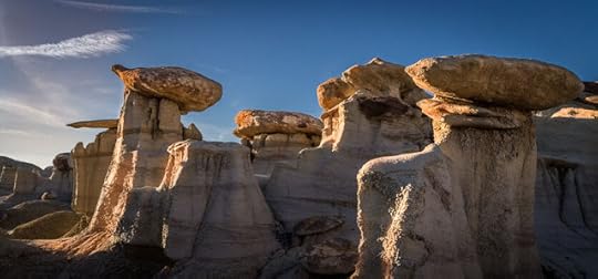
6 December 2021 - STUNNING SAN JUAN BASIN in NEW MEXICO
STUNNING SAN JUAN
BASIN in NEW MEXICO
G'day folks,
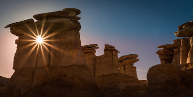
The land is full of geologic eye candy like otherworldly spires, mushroom-shaped hoodoos, and prehistoric fossils.With its muted colors and striking geology, this unusual landscape feels like a martian planet. Pale, mushroom-shaped hoodoos loom above the rocky earth like enormous alien trees. Petrified tree stumps and ancient bones speckle the badlands like prehistoric markers of its long-gone inhabitants.
Located in the arid San Juan Basin of northwest New Mexico, the Ah-Shi-Sle-Pah Wilderness Study Area is located on 6,563 acres of public Bureau of Land Management land. It’s a hidden wonder of weathered rock formations often referred to as hoodoos (not to be confused with witchcraft or the evil eye), tent rocks, fairy chimneys, earth pyramids, or mushrooms.
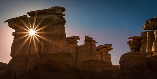
Geologically, the area is comprised of layers of sandstone, shale, mudstone, and bituminous coal that were deposited 75 million years ago during the late Cretaceous era. A whopping 75,000 millennia of wind, water, and ice weathering and eroding the layers are responsible for the surreal and alien-esque landscape.
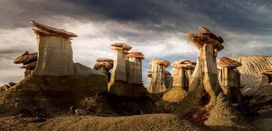
Because of its geologic age and climate, the area is rich with animal and plant fossils. The remains of prehistoric crocodiles, turtles, fish, and dinosaurs are sprinkled throughout the land. You’ll also see petrified wood, including numerous upright tree stumps with roots. Fossils are not allowed to be collected.
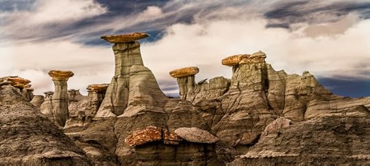
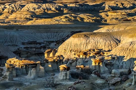
While it’s somewhat challenging to get there, visitors are rewarded with a tranquil, if not dreamlike, environment which is easy to navigate. Although the formations extend for six miles along the Ah-Shi-Sle-Pah Wash, the most accessible and picturesque formations are within one to two miles of the parking area and can be seen within half a day of easy walking along the generally flat terrain.

Clancy's comment: This is one place I'd like to visit with my cameras.
I'm ...


October 14, 2021
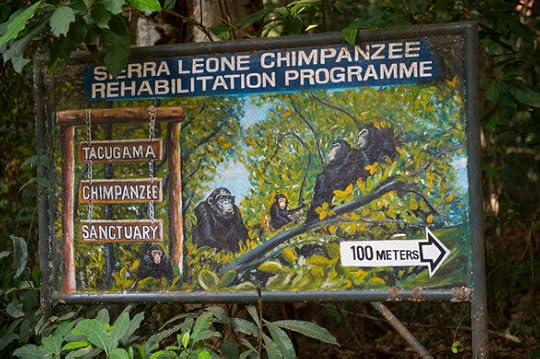
5 December 2021 - TACUGAMA CHIMPANZEE SANCTUARY - SIERRA LEONE

TACUGAMA CHIMPANZEE
SANCTUARY - SIERRA LEONE
G'day folks,
Welcome to a rehabilitation centre for confiscated, orphaned, and abandoned chimpanzees.The center was established for the rehabilitation of confiscated, orphans and abandoned chimpanzees. Located just outside Freetown, in the Western Area Peninsula National Park, Tacugama Chimpanzee Sanctuary provides guided tour in a unique context, a forest enclosures, where is possible to see chimpanzees up close.
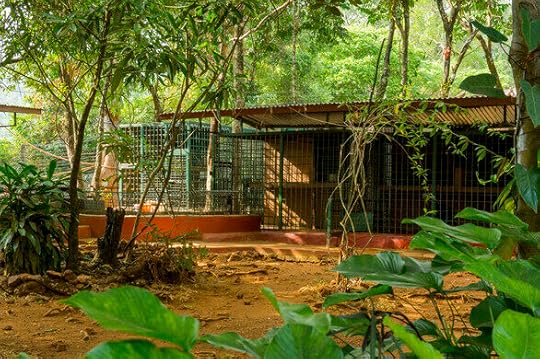

The sanctuary was founded in 1995 by Bala and Sharmila Amarasekaran. Starting in the late 1980s, the husband-and-wife conservationist team had worked with primatologist Rosalind Alp to gather data on chimpanzees in the pet trade in Sierra Leone. Even after being rescued, many of the primates who had spent time as pets could not be returned to wild, which led to the idea for a chimpanzee sanctuary. When it first opened, there were five chimpanzees: Bruno, Julie, Charlie Boy, Philip, and Augustine.

Since then, Tacugama has grown into a large and diverse organization. In addition to caring for nearly 100 chimpanzees on-site, the sanctuary is involved in community outreach, field research, and conservation education. Tacaguma even kept to work during Sierra Leone’s civil war, which ended in 2002. Tacaguma helps monitor the country’s chimpanzee population, and once hosted the only documented albino chimpanzee.
The center also has several eco-lodges (without electricity) where visitors can spend the night.

Clancy's comment: Great to see places like this.
I'm ...


October 13, 2021
10 December 2021 - CROW CANYON PETROGLYPHS - NEW MEXICO
CROW CANYON PETROGLYPHS
- NEW MEXICO -
G'day folks,
Welcome to one of the American Southwest's most extensive collections of Navajo rock art.This rocky swath of land in New Mexico is home to an abundance of archaeological ruins. The Crow Canyon Petroglyphs in particular are said to be the American Southwest’s most extensive collection of Navajo rock art from the 16th through 18th centuries.
The Crow Canyon Archaeological District is a remote and relatively obscure area in the heart of Dinétah, which is the traditional and ancestral homeland of the Navajo people. The foundations for the Navajo culture were well established in the area, dating back as far as the year 1100. The Navajo lived within Dinétah until about the late 1700s, when they were forced to abandon it and move elsewhere because of pressure from the Ute people and encroaching Spanish settlers.
The artwork in Crow Canyon preserves traces of the people who once called the land home. Most of the petroglyphs are clustered into “panels” carved predominantly within the canyon’s south-and-east-facing walls. Gazing upon them is like viewing a gallery full of hundreds of stylized animals, people, crops, weapons, and supernatural beings.
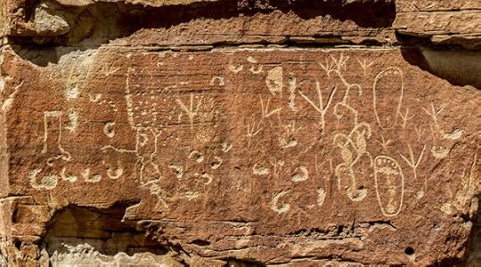
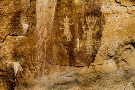
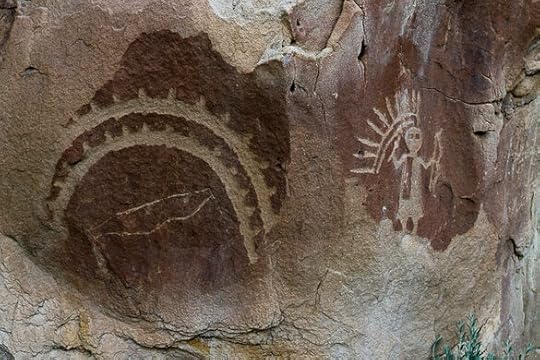
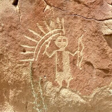
Because the petroglyphs appear similar to Navajo ceremonial sand paintings, archaeologists believe these were likely linked to a ceremonial purpose as well. You’ll also see much older Ancestral Puebloan rock art intermingled with the Navajo petroglyphs.
In addition to petroglyphs, Crow Canyon contains several Navajo pueblitos (archaeological ruins), built in the 16th and 17th centuries. They are, for the most part, less accessible than the petroglyphs.
Today, the Navajo Tribe is the largest Native American tribe in the United States, with more than 250,000 members.

Clancy's comment: Stunning pictures.
I'm ...


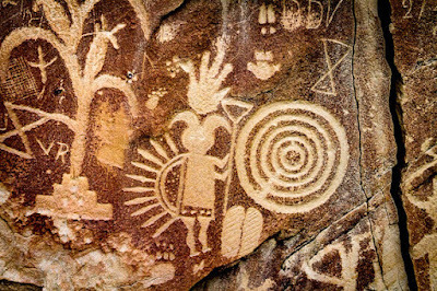
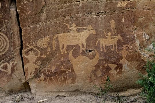
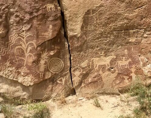
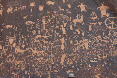
14 October 2021 - THE EXTRAORDINARY NEWSPAPER ROCK IN UTAH
THE EXTRAORDINARY
NEWSPAPER ROCK IN UTAH
G'day folks,
One of the world’s largest collections of petroglyphs records 2,000 years of human activity.
For approximately 2,000 years, Native Americans have been carving petroglyphs into a single slab of sandstone located in San Juan County, Utah. While the precise meaning of the petroglyphs is not fully understood, the panel nonetheless provides an intriguing insight into human activities in the area.
Petroglyphs are hard to date, but archaeologists believe the earliest petroglyphs on Newspaper Rock likely date back to the Archaic, Basketmaker, Fremont, and Pueblo cultures, up until around 1300. Later, Utah, Navajo, and Anglo tribesmen added to the panel. In the Navajo language, the rock is aptly known as Tse’ Hane, or “the rock that tells a story.”

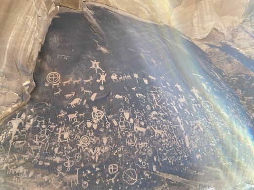
About 650 individual designs cover the surface of the 200-square-foot rock, making it one of the largest collections of petroglyphs in the world. The petroglyphs were made by chipping away at the desert varnish, a dark coating found on exposed rock surfaces in arid environments, to reveal the lighter rock beneath.

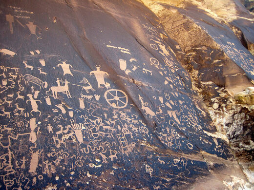
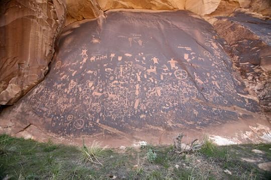
The designs range from abstract shapes and symbols to more recognizable human and animal figures. Some of the stranger designs include wagon wheel-like shapes and bizarre, broad-shouldered humanoid figures with horns on their heads. Others depict deer, buffalo, bighorn sheep, lizards, snakes and turtles.
More recent carvings, beginning around 650 years ago, show men on horseback, some armed with bows and arrows. The relative age of the petroglyphs can be determined by the amount of desert varnish covering the figures, with the older designs typically being darker in color due to the repatination of surface minerals.

Clancy's comment: I could stare at these for hours. Simply stunning.
I'm ...


October 12, 2021
3 December 2021 - THE FAMOUS COTTON TREE IN FREETOWN

THE FAMOUS COTTON
TREE IN FREETOWN
G'day folks,
The oldest of its kind in the country, this tree sits where formerly enslaved people are said to have founded the city of Freetown.The historic symbol of Freetown, the capital of Sierra Leone, is a large kapok tree known as the “Cotton Tree.” According to legend, the tree gained importance in 1792 when a group of formerly enslaved people settled the site of what is now Freetown.
After the American Revolution, the British granted freedom to the enslaved people who had fought with the Crown during the war. Some so-called “Black Loyalists” were given land and supplies to resettle in British-controlled Nova Scotia, while others went to London and parts of the Caribbean. In 1787, some 4,000 formerly enslaved people were resettled in Sierra Leone—regardless of where they or their ancestors had originally come from. Five years later, another group emigrated from Nova Scotia to Sierra Leone.
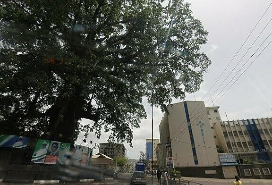
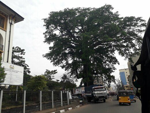
According to the story, when the first boat arrived, they walked up to a large tree just above the bay and held a Thanksgiving service there, praying and singing hymns. That tree still stands, now between the courthouse and the National Museum. Though its exact age is unknown, it is known to have existed in 1787 and believed to be the oldest cotton tree in the nation. The Cotton Tree is an iconic monument in the capital and appears on the 10,000 Leones banknotes.

Clancy's comment: Let's hope it lasts forever.
I'm ...


October 10, 2021
2 December 2021 - THE CAMONDO STAIRS IN GALATA, TURKEY
THE CAMONDO STAIRS IN
GALATA, TURKEY
G'day folks,
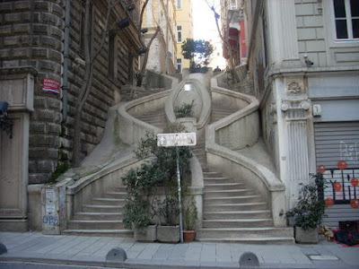
Here is a gorgeous, Gaudí-esque stairway constructed in the city of Galata by a prominent Jewish family.A prominent Sephardic Jewish family, the House of Camondo (or Kamondo), established themselves in the Galata district of Istanbul after Austrians took over Venice in 1798. A few years later, they founded their own bank branching into finance.
Abraham Salomon Camondo, brother of the bank’s founder, inherited the bank after his brother Isaac died in 1832. Until the Imperial Ottoman Bank was founded in 1863, he served the empire as its prime banker. He financially assisted Venice and aided in ts liberation from Austrian control. For these contributions, he was ennobled by King Victor Emmanuel II of Italy in 1870.
Abraham died three years later, but his two grandsons succeeded in expanding their banking business in Paris. The family did not survive World War II, as the last of its members were murdered in Auschwitz.
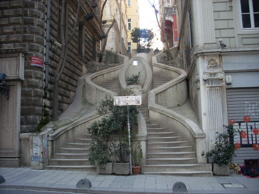
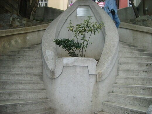
Their legacies can still be found in Istanbul, including their seaside mansion, which is currently used by the Turkish Navy. But the most notable, and perhaps most loved is the Camondo Stairs in Galata, which were built by Abraham Salomon Camondo during the 1870s.

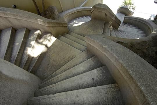
Designed with a fusion of the Neo-Baroque and early Art Nouveau styles, this curvaceous, almost Gaudí-esque stairway was constructed as a shortcut for Camondo to reach Bankalar Caddesi (Banks Street), and for his children to go to school. Its hexagonal shape is believed to have been designed to prevent his children from falling further down the steps should they slip.

Clancy's comment: What a great legacy, eh?
I'm ...


October 9, 2021
4 December 2021 - TURKISH TRAIN CLIMBS STEEP HILL IN 90 SECONDS
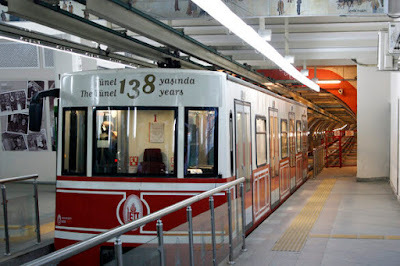
TURKISH TRAIN CLIMBS
STEEP HILL IN 90 SECONDS
G'day folks,
This train can climb a steep hill in 90 seconds on the second-oldest urban subway in the world.This short railway has served Istanbul’s residents and visitors since the late 19th century. It is the oldest existing underground train in continental Europe, and second-oldest in the world after the London Underground.
In the mid-19th century, the Ottoman Empire was opening to international trade and many Europeans began to settle in the then capital. Many of them lived in the Pera neighborhood (today known as Beyoğlu), where residences, luxury hotels, and embassies were located at the top of a steep hill, and the banks, warehouses, and exchange offices where many Europeans worked were located at the base, closer to the ports lining the Golden Horn.
When the French engineer Eugène-Henri Gavand first arrived in Istanbul in 1867, he was surprised to see how many people trekked down and up the steep hill on Yüksek Kaldirim Avenue every day. He thought a funicular railway would make the trip easier.


Gavand returned to France to prepare his project, and in 1869 presented it to Sultan Abdelaziz. The project was approved but delayed for several years during the Franco-Prussian War. Construction resumed after the war and Tünel opened to the public in January 1875.
At that time, the train consisted of a steam engine pulling two wooden cars. The first car held passengers, while the second was used to transport goods livestock and carriages.
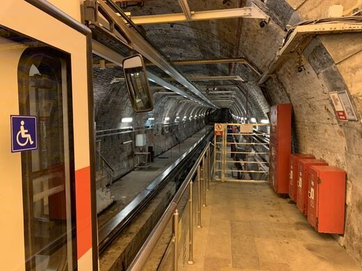
The line was closed for modernization in 1968, reopening in 1971 with electric power and steel cars. It continues to operate today. The Tünel is part of the historic city’s transportation network, moving about 12,000 people between the Karakoy and Beyoğlu stations every day.

Clancy's comment: Istanbul is one of my favourite cities.
I'm ...


October 8, 2021
9 October 2021 - MAN FEEDS ANIMALS LEFT IN FUKUSHIMA

MAN FEEDS ANIMALS
LEFT IN FUKUSHIMA
G'day folks,
The Fukushima disaster was a nuclear disaster at the Fukushima I Nuclear Power Plant in Japan that began on March 11th, 2011. It resulted in a nuclear meltdown of three of the plant’s six nuclear reactors. The failure occurred when the plant was hit by a tsunami that was the result of a 9.0 magnitude earthquake.
The following day, March 12th, substantial amounts of radioactive material began to be released. This made it the largest nuclear incident since the Chernobyl disaster that occurred in April of 1986. Although no fatalities due to short-term radiation exposure were reported, approximately 300,000 people were evacuated from the area.


Due to various reasons, the people who were evacuated were not able to take their pets or farm animals with them when they were evacuated. This is where Naoto Matsumura comes into the picture. He is a fifty-five year old construction worker. He lives in the evacuated zone to care for the animals left behind. Why would he do that you might ask? Because they needed him.
Every day he is there, he is risking his own health and safety to care for the many animals that were abandoned when the area was evacuated.
He knows that every day he is there, his body is getting subjected to major radiation. He says that he, “Refuses to worry about it.” He does take steps, however, by only eating food imported into the zone.

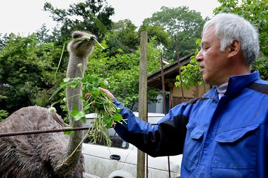
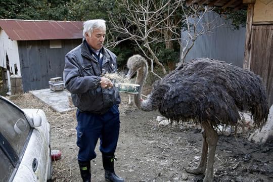
He is currently the only human brave enough to live in the evacuation zone, and a lot of animals were chained up by their owners, so he set them free.

Clancy's comment: Go, Nato! What a great human. Naoto has now been in the evacuation zone for about 4 years and has no plans to leave. If you are wondering where he gets the money to pay for all of the food for the animals, the answer is pretty great. All of the money comes from donations from supporters of his cause. If the donations ever dry up, he would no longer be able to feed and care for all of the animals in the evacuation zone.
I'm ...


October 7, 2021
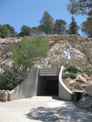
30 November 2021 - STUNNING AVSHALOM CAVE - ISRAEL
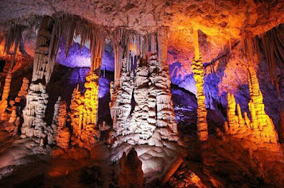
STUNNING AVSHALOM CAVE
- ISRAEL -
G'day folks,
This amazing ancient cave was kept secret for seven years to protect it from the public.In May 1968, workers at the Hartuv quarry in the Judean Hills were quarrying with explosives. Each blast was much like the one before, until a strange gap opened up in the rock face. Peering inside, the men discovered a large cave, its roof dripping with stalactites, the oldest of which would later be dated to around 300,000 years old.
After its discovery, local authorities decided to keep the cave a secret, fearing the ancient formations would be damaged if it were opened to the public. Seven years later, on March 16, 1975, the cave was declared a nature reserve and its secrets were revealed.

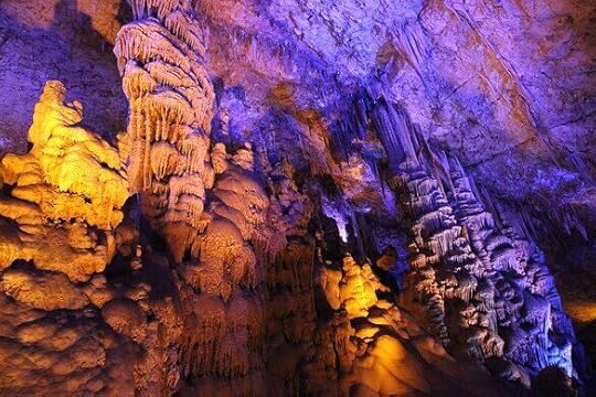
The Avshalom Cave, also known as the Soreq Cave, has since become one of Israel’s most incredible natural wonders. From the roof of the 50,000-square-foot cavern hangs a forest of stalactites, the largest more than 13 feet long, slowly formed over millennia by the slow dripping of water through cracks in the ceiling. Rising up from the floor beneath them are a series of towering stalagmites, while some stalactites and stalagmites have joined to form pillars.
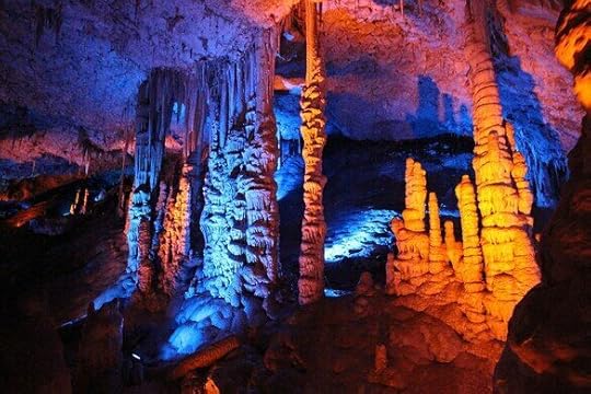
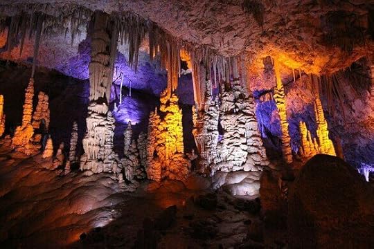
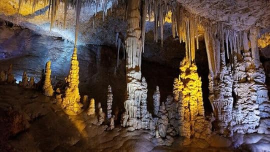
The result is a strange subterranean world of bizarre formations, with organic-looking shapes that resemble coral reefs and tentacles. Other formations have been compared to a whole range of objects: elephant ears, ice cream cones, the Lion King, and the U.S. Capitol Building.
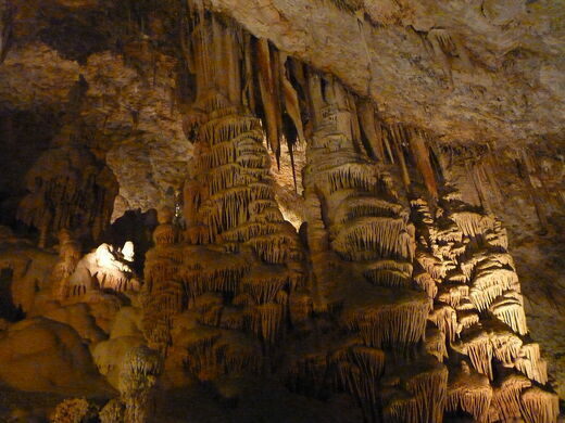
The whole effect has been made even more trippy since the installation of a modern lighting system. For years, the cave was illuminated by the white light of automobile headlamps. This, however, triggered photosynthesis and the algae inside the cave began to grow, threatening to cover the bare rock formations in a uniform smudge of dark green moss. The park officials then tried using ultraviolet light at night to kill the algae, but the algae eventually developed an immunity to UV light.
In 2012, a new anti-algae tactic was employed. A lighting system was installed that used only a limited part of the color spectrum, with shifting shades of orange, blue and green. Not only did this help to control the algae, it also gave the cave an otherworldly appearance that made the whole experience all the more memorable.
At the time, some park officials had mixed feelings about the new lighting, worrying it would detract from the cave’s natural beauty. Boris Kripak, a Russian-born archaeologist who worked at the cave, told the Los Angeles Times: “We don’t want to turn the cave into a discotheque.” But he also admitted that the shifting colors, which range from bright orange to deep purple, had given new life to the ancient cavern, saying “It’s like the cave is breathing.”

Clancy's comment: Stunning to think that it was found by accident.
I'm ...


27 November 2021 - WATER-POWERED FUNICULAR RAILWAY
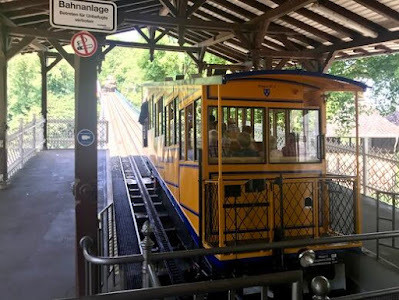
WATER-POWERED
FUNICULAR RAILWAY
G'day folks,
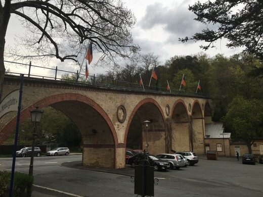
A rare water-powered funicular uses a huge tank of water and gravity to do its work.A 440 metres long funicular railway in the city of Wiesbaden linking Neroberg hill to its north, Nerobergbahn opened in 1888, and is one of the few remaining funiculars to use water propulsion.
At the upper station, tanks on the downbound car are filled with up to 7,000 litres of water in order to ensure that it is heavier than the upbound car. The downbound car then pulls the upbound car uphill under the power of gravity and by means of a 452 m long steel cable. When the downbound carriage arrives at the lower station, the water is discharged and pumped back uphill.

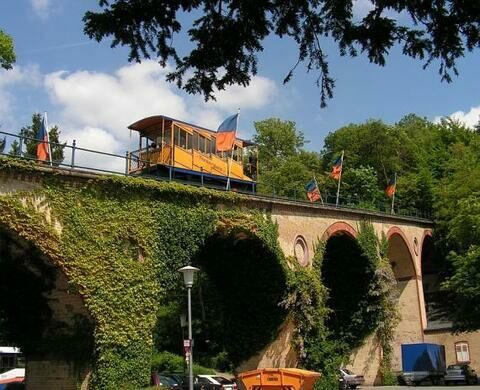
In 1939, it was planned to convert the line to electric propulsion, and to provide larger cars, but the outbreak of World War II prevented this. The line was taken out of service in 1944 due to war damage, but service was restarted in 1948. In 1988 the line was protected as a technical monument by the State of Hesse.
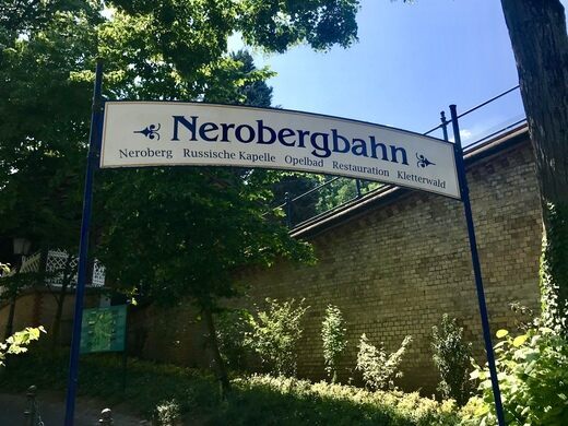
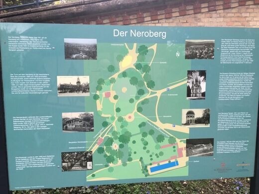
Nerobergbahn is operated only in the summer months as there is danger of freezing in the winter.

Clancy's comment: Amazing, eh?
I'm ...