
Clancy Tucker's Blog, page 25
March 4, 2022
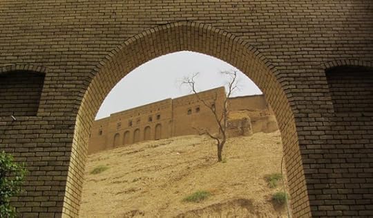
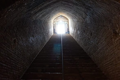
24 April 2022 - ERBIL CITADEL - IRAQ

ERBIL CITADEL
- IRAQ -
G'day folks,
Welcome to an ancient fortified mound raised over the millennia from settlements built one on top of the other.
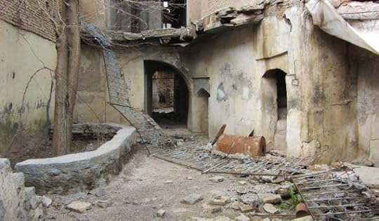
Settlements built on top of older settlements for 7,000 years have created a large elevated mound in the heart of the historical city of Erbil (also known as Hawler) in the Kurdistan Region of Iraq. On top of the elevated ground, Erbil Citadel stands witness to the passing of time and history.
Erbil Citadel is a fortified ovoid-shaped ancient mound. Seen from above, the mound of earth sprouts from the otherwise flat surrounding terrain. The elevation is due to millennia of settlements built one on top of the other. Dwellings were usually made of mud bricks, which in time disintegrated and contributed to heightening the overall ground of the citadel, which raised more than 100 feet over the centuries.
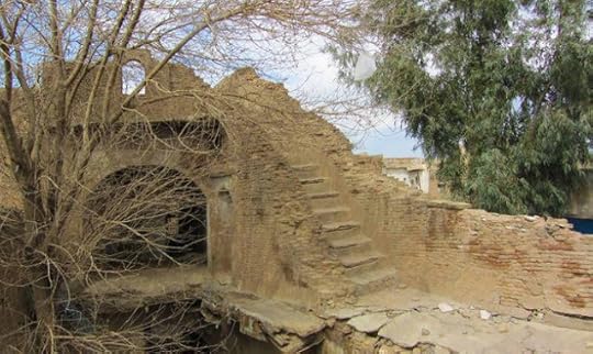
The first recorded document that mentions the citadel is from 2300 B.C., but the most ancient traces date back to 5000 B.C. Unsurprisingly, the citadel has undergone several phases of destruction and reconstruction. Although Kurdish and Assyrian people tended to inhabit the citadel, various waves of outsiders went through, including Sumerians, Mongols, Ottomans, and Europeans.
In 2007, extensive international archaeological excavations began. In 2014, UNESCO welcomed the citadel among the list of World Heritage Sites.
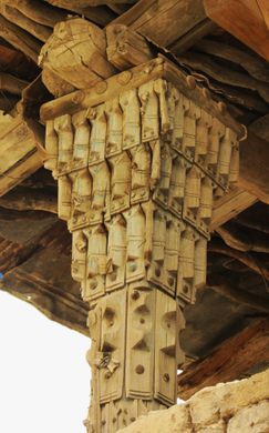
The area occupied by the Erbil Citadel is just over 10 hectares (1,410 x 1,120 feet), and it mainly consists of a main thoroughfare in the middle and a dense set of criss-crossing alleys. There are currently three entrances and hundreds of houses on the ancient mound. Of the surviving buildings, the oldest dates back to 1893, and the only religious building left is the Mullah Afandi Mosque.
A fortified wall circumscribes some segments of the perimeter of the citadel, while other segments are marked by the contiguous facade of houses built on the edge of the mound. These days, a statue of historian Mubarak Ben Ahmed Sharaf-Aldin guards the South gate.
Clancy's comment: The more I research history, the more I am astounded by what people constructed so many centuries ago.
I'm ...


28 April 2022 - NUSHABAD UNDERGROUND CITY - IRAN
NUSHABAD
UNDERGROUND CITY
- IRAN -
G'day folks,
Welcome to a 1,500-year-old, 3-story subterranean city where ancient Persians took refuge in times of war.
Just north of Kashan, in the small town of Nushabad, Iran (also spelled Noosh Abad), lies a sprawling underground city. Despite its impressive scale, the ancient buried shelter was completely unknown until a decade ago, when an oblivious resident stumbled upon a tunnel while digging a sewage ditch in his home.
What was discovered was an extensive, 1,500-year-old underground city, set between 3 to 18 meters (10 to 60 feet) deep. The labyrinthine network was comprised of three stories of tunnels, chambers, air ducts, staircases, canals, and booby traps. It’s considered a marvel of ancient architecture and engineering.
Construction of this man-made subterranean city, called Ouee (or Ouyi), dates back to the Sasanian (or Neo-Persian) Empire that ruled from 224 to 651. Inhabitants would dig underground chambers as hideout spots for women, children, and the elderly in the event of an attack by foreign invaders.

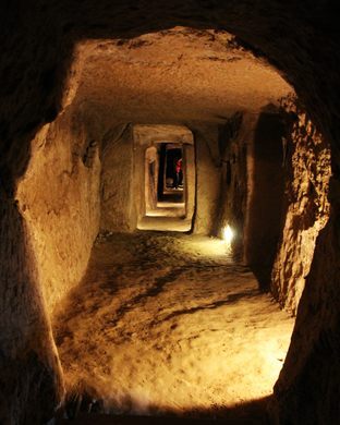
Over the years, the individual chambers were amalgamated, and air ducts, water pipes, storage spaces, and toilets were all built—creating a sustainable underground city that was used as a refuge during times of war. Each family had their own room of sorts, with a tunnel running down the length of these rooms, similar to a hotel hallway.

Clancy's comment: What an extraordinary find.
I'm ...


March 3, 2022
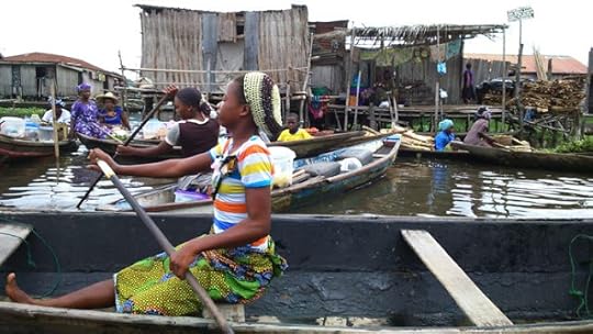
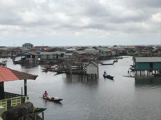
23 April 2022 - GANVIE LAKE VILLAGE
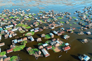
GANVIE LAKE
VILLAGE
G'day folks,
Welcome to Venice on stilts.
In colonial Brazil, runaway slaves and free natives formed communities deep within the Amazon as a means of escaping the brutality of Portuguese slavery. A combination of dense vegetation, waterways, and perilous wildlife and disease separated these societies from the slave traders who pursued them.
A small group of people outside of what is now Cotonou, Benin, took advantage of a different set of circumstances to evade capture by the Portuguese. At the time, the powerful West-African Fon tribe was hunting and selling other native tribesman to the Portuguese. While there were few physical impediments protecting the ancestors of today’s Ganvie village from outside attack, Fon religious practice forbade their raiders from advancing on any peoples dwelling on water, laying the groundwork for the Ganvie Lake Village.

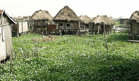
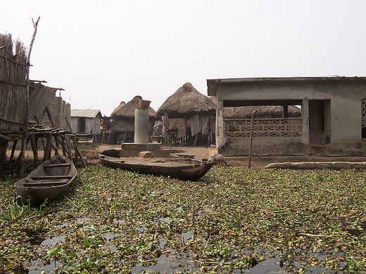


Ganvie is a village of roughly 20,000 people that stands on stilts in the middle of Lake Nokoue. The founders of the village fled there to avoid Fon warriors, and in the roughly 500 years that have passed since, Ganvie has developed an intricate and prosperous culture within the constraints of life on the lake.
A school is the only one of Ganvie’s 3,000 buildings that exists on land, although a cemetery mound is currently under construction. The villagers of Ganvie travel almost exclusively by boat, and the few domesticated land-animals they maintain live on plots of grass that spring up from the water. Without a good supply of domesticated animals, Ganvie relies on a complicated network of underwater fencing to corral and farm various fish populations.
The village sits several miles from the nearest shoreline and is about a 4 hour journey from the capital. Ganvie is Africa’s largest lake village.
Clancy's comment: Where there is a will, there is a way.
I'm ...

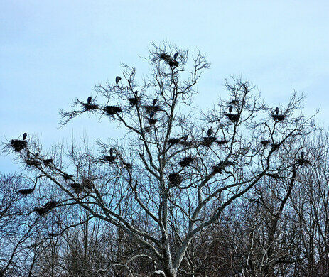
4 March 2022- BATH ROAD HERONRY - OHIO

BATH ROAD HERONRY
- OHIO -
G'day folks,
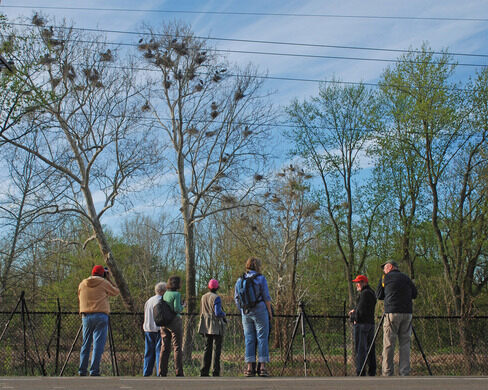
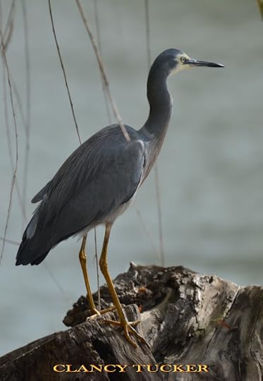
Beside a busy highway, a colony of Great Blue Herons raises hundreds of offspring each year.Every year around Valentine’s Day, hundreds of great blue herons (Ardea herodias) descend upon the Cuyahoga Valley National Park in Northeast Ohio to engage in their annual courtship and mating rituals. The birds build their nests in communal rookeries called heronries. Heronries typically appear in secluded areas, and the birds are ordinarily cautious and skittish. They’re usually surrounded by marshland, and observable only by the most intrepid birdwatchers. The Bath Road Heronry is unusual because of its proximity to the busy highway between Riverview and Akron-Penninsula Roads. It affords people a rare opportunity to see an active heron rookery without trudging through miles of wetlands. Because the road is so heavily traveled, there’s a pull-off to prevent vehicles from obstructing traffic while birders view and photograph the nests and their occupants.
Blue herons were first observed nesting in the Cuyahoga Valley National Park in 1985. Since that time, the birds have grown in number and return annually. The Bath Road Herony peaked at 176 nests in 2003. Unfortunately, the loss of two trees during the ensuing years reduced the number of viable nesting places. Since that time, the nest numbers have ranged from 50 to 100. In 2006, another heronry appeared in a more remote area to the north.
The Bath Road nests occupy three enormous sycamore trees on the south side of West Bath Road. The area is marshy and close to the Cuyahoga River, with its plentiful supply of fish and amphibians. Nothing more than a chainlink fence separates the nesting area from the highway.
The heron nests are large—up to four feet in diameter and two feet deep—and between 30 and 70 feet off the ground. Each nest is constructed from a platform of sticks and branches, and lined with pine needles, moss, grass, and leaves. Although rickety in appearance, the nests are stable enough to support the weight of two big parents and up to seven jostling nestlings. Great blue herons are North America’s largest herons. At four feet tall with a wingspan of seven feet (at up to 5.5 pounds, since they are birds, after all), they are very hard to miss.

Their mating behavior is charming. Couples can be observed “clappering”—quickly and repeatedly clicking their long bills together in a mating display. Courtship continues when the male heron presents the female with a stick. If she accepts, they are bonded and commence building or remodeling their nest. Nest construction or repair is usually completed by early April. A clutch numbers three to seven eggs that are incubated by both parents for 28 days.
Hatching begins in late April or early May. For two months, observers can watch the parents continually flying between the heronry and the Cuyahoga to bring food to their growing offspring. The gangly youngsters are easily viewed from Bath Road as they stand in the nests and compete for food. The herons remain at the rookery until they fledge in early July. The abandoned nests remain through the fall and winter months, awaiting the herons’ return in February.
Clancy's commment: I've photographed these and similar birds in SE Asia ... lying on my back with a long camera as they flew over me like Jumbo Jets.
I'm ...


March 2, 2022
27 April 2022 - LEKKI CONSERVATION CENTRE - NIGERIA
LEKKI CONSERVATION
CENTRE
- NIGERIA -
G'day folks,
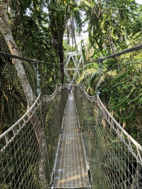
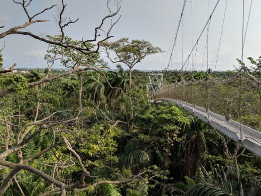
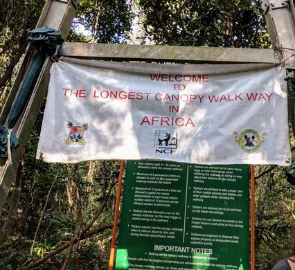
This Nigerian nature reserve is home to the longest canopy walkway in Africa.
The Lekki Conservation Center in Lekki, Nigeria, is an oasis of nature within the urban chaos of Lagos, and the suspended canopy walkway that rises over the reserve is the longest in all of Africa.
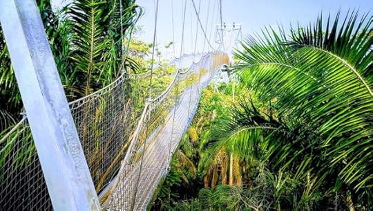

The canopy walkway features six towers that rise over 22 feet each. They are connected by a series of suspended (and swinging) walkways that offer a unique (if somewhat harrowing) 360-degree view of this part of the world from high above the treetops. The treetop walk stretches about 1,315 feet long (more than three and a half football fields), setting the record for the longest on the African continent.
Founded in 1990 by the Nigerian Conservation Foundation, the conservation center preserves a large part of the region’s biodiverse coastal ecosystem and educates visitors on the importance of coexisting with nature. The reserve is home to a plethora of wildlife, including monkeys, tortoises, and rare birds.
Clancy's comment: What a great place for photographers to capture wildlife.
I'm ...


26 April 2022 - FAKE NEWS FOOLED HITLER ON D-DAY

FAKE NEWS FOOLED
HITLER ON D-DAY
G'day folks,
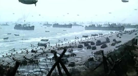
The biggest land, air and seaborne invasion the world has ever known was launched on June 6th 1944. Codenamed Operation Overlord, everybody now knows it as D-Day.
One hundred and fifty six thousand American, British and Canadian troops sailed to France from England and stormed the beaches of Normandy. They then began a relentless, dogged and bloody drive all the way to Berlin, pushing back the fearsome German military machine and finally bringing an end to the Second World War.
It was no picnic. The 50-mile stretch of coast where the landings took place was heavily fortified by Hitler’s forces, and his soldiers, who had never known defeat, put up staunch resistance.
An element of surprise worked in the Allies’ favour. Hitler believed that an invasion would come along France’s northern coast, but he did not know where. He had put Field Marshal Erwin Rommel in charge of defence operations, including completion of the Atlantic Wall, a 2,400-mile fortification of bunkers, landmines, beach and sea obstacles.
In England, meanwhile, deception was the name of the game – on a massive scale. It included an imaginary army of a million men, supposedly led by America’s General George Patton and headquartered in the UK across from Calais – the shortest distance between England and France.
With the use of double agents, bogus radio transmissions and other means the Germans were made aware of this "army". They were also briefed over other possible invasion sites including Greece, the Adriatic coast of Yugoslavia, the south of France, the Biscay Bay coast of France, through the Low Countries, or via Norway and Denmark. Hitler moved garrisons into all these places.

It was, according to ‘America in WWII’ magazine, “the greatest deceptive enterprise ever seen in a war. Tent cities were created all over eastern England. There were fake mess halls, hospitals, ammo depots, and even sewage treatment farms. Fuel depots were constructed and parks for trucks, tanks, jeeps, and ambulances were laid out.”
Like the buildings, the tanks, trucks and other “vehicles” were made of fabric and wood or were rubber inflatables. Soldiers used tools to make tread and tyre marks for the benefit of spying German planes. It was vital to let Luftwaffe reconnaissance planes through to see the mock preparations on the ground, but not let their flights seem suspiciously easy.
On top of all that, the deceptions extended to England’s ports and waterways with the help of the British movie industry, which was called in to make fleets of dummy landing craft. The resulting “vessels”, made of wood or fabric and floating on oil drums, were “moored” in harbours and rivers and looked convincing to German pilots at 33,000 feet.
The subterfuge even extended to “letters” in local newspapers from clergymen complaining about the terrible behaviour of some of the “foreign troops.”
All of this shifted much German attention away from Normandy and so, on June 6, 1944 the Supreme Commander of the Allied Forces, America’s General Dwight D. Eisenhower, gave the order for the invasion to begin.
Even as troops began wading ashore along the Normandy beaches, the fooled Germans still believed that the major assault would come at Calais and that Normandy was a feint. Hitler personally ordered the tanks and infantry of the German 15th Army to stay at Calais. And other reinforcements on the way to Normandy were diverted to the port.
Official figures record that 4,414 Allied troops lost their lives in the D-Day invasion, with another 10,000 wounded or missing. But it enabled the great Allied march across Europe to begin.
By late August all of Northern France, including Paris, had been liberated from German control. Next came Germany itself, where the Allies would meet Soviet troops moving in from the east. The following spring, on May 8, 1945, Nazi Germany offered unconditional surrender. Hitler had committed suicide a week earlier, on April 30.
What does the ‘D’ in D-Day stand for? In military parlance it simply refers to the “day” on which an offensive would occur. The “D” is just a placeholder for the date and allows the entire operation to be scheduled in detail long before a definite day for the attack has been set. So, if anything, 'D' stands for 'Day' or 'Date.' The phrase was first used during the First World War.
Clancy's comment: What a massive event.
I'm ...


February 28, 2022
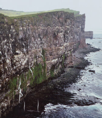
22 April 2022 - EUROPE'S LARGEST SEABIRD CLIFF
EUROPE'S LARGEST
SEABIRD CLIFF
G'day folks,
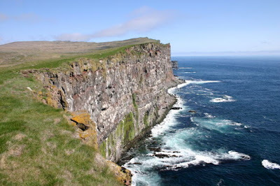
Puffin enthusiasts flock to Europe's largest seabird cliff, which over one million birds call home.Látrabjarg, Iceland’s westernmost point, is also the largest seabird cliff in Europe. Over one million birds pepper the wind-battered crags, protected from predators while perched within the rocks that jut out from their towering domain.
The puffins, of course, are typically the star attraction. The adorable orange-beaked creatures are fairly comfortable around the humans who brave the fierce winds that tear through the air. You’ll typically find them peeping out from the grass that coats the top parts of the cliffs.
Látrabjarg is a key site for seabird conservation. In addition to the puffins, you’ll find other seabirds like guillemots, razorbills, and northern gannets clustered throughout the rocks. At times, the area houses approximately 40 percent of the world’s razorbill population.

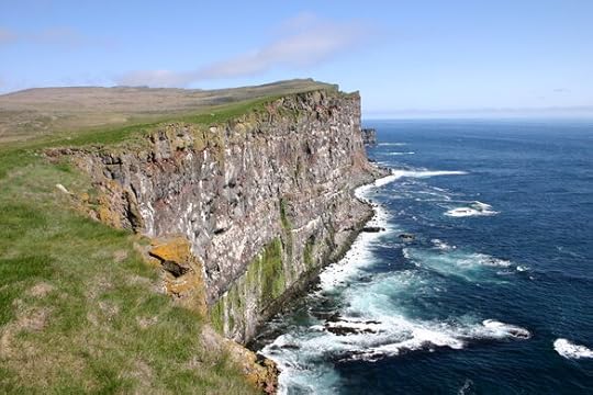
The cliffs also boast splendid hiking and photography opportunities for those who can stand the wind. The nearly nine miles of over 1,000-foot-tall cliffs offer a chance to walk Iceland’s most western perimeter. Be sure to stop for a bit to take in the views of the Atlantic Ocean, which merges uninterrupted with the distant horizon.
If you do decide to walk along the cliffs, make sure you stay behind the white line that’s painted near the edge. It’s there to keep you from accidentally falling and plummeting into the churning waters far below.
Clancy's comment: A top spot for wildlife photographers like me.
I'm ...

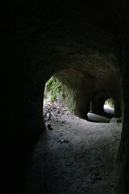
21 April 2022 - JAPANESE TUNNELS IN RABAUL
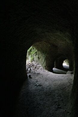
JAPANESE TUNNELS
IN RABAUL
G'day folks,
This volcanically volatile island town is home to an abandoned series of tunnels left by the Japanese during WWII.Home to two active volcanoes and some of the most abundant earthquake activity in the world, the township of Rabaul in Papua New Guinea does not seem to be the ideal place for a massive military encampment. But thanks to a strategically significant harbor, the Japanese built one anyway during World War II, leaving behind over 500 miles of tunnels snaking beneath the island when they were routed.
Japanese forces overtook the town of Rabaul in 1942 as WWII was in its final years, and quickly established a massive military complex serving their navy, air force, and, infantry. At its height, the Rabaul base and its surrounding encampment served over 97,000 soldiers and thousands more accompanying personnel.
Due to the island’s remote location, the main threat to the base was bombardment from the air, which was frequent and often devastating. To counteract this, hundreds of miles of tunnels were built beneath the town where a number of fully functioning facilities were installed. The tunnels were dug by laborers who were captured in Malaysia, China, and Singapore and transported to Rabaul. Many of these laborers died from disease, starvation, poor treatment, and overwork. The Japanese also used local Tolai labor from surrounding villages and prisoners of war.


The hospital, barracks, storehouses, and command centers were moved into the underground labyrinth with some of the chambers built as large as four stories tall. Some of the tunnels were hewn right from the existing rock, and some were crude structures supported by palm beams, while others still were fully built out concrete bunkers. All in all, the system became one of the longest and most elaborate in the world.
When the Japanese were driven from the island at the end of the war, the base and its copious tunnels were simply left behind. Today, most of the contents of the base have been cleared out but dangerous ammunition and other remnants can still be found in the depths of the tunnels. A volcanic eruption in 1994 nearly buried the entire city beneath volcanic ash and most of the populace were forced to evacuate, but the area is slowly recovering and the tunnels beneath the island are slowly being rediscovered.
Clancy's comment: Many Australians would have died here. Lest we forget ...
I'm ...


19 April 2022 - BA 64 - THE OLDEST STEEL SHIP IN ICELAND
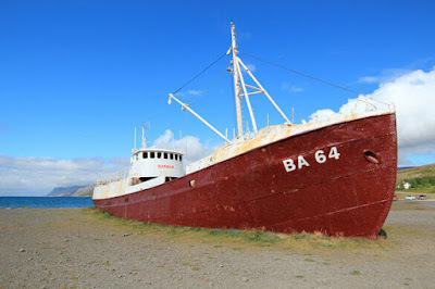
BA 64
- THE OLDEST STEEL
SHIP IN ICELAND -
G'day folks,
The oldest steel ship in Iceland has been beached for years and is now a rusting ruin.Launched the same year that the Titanic met its final fate, the whaling ship that came to be known as Garðar BA 64 was a hulking hybrid of a ship, having both a powerful steam engine in addition to traditional sails.
Originally known as the Globe IV, the large ship was completed in Norway in 1912 as a state-of-the-art-at-the-time whaling vessel. The hull was specially reinforced to break through the icy Southern seas in which it operated and the powerful engine kept the boat sailing even in calm waters. During its active lifetime it was sold around to a number of different countries before finding an Icelandic owner after World War II. Once whaling restrictions became more widespread, Garðar BA 64 (a name it finally received in 1963) was used for fishing herring in the waters off of Iceland.
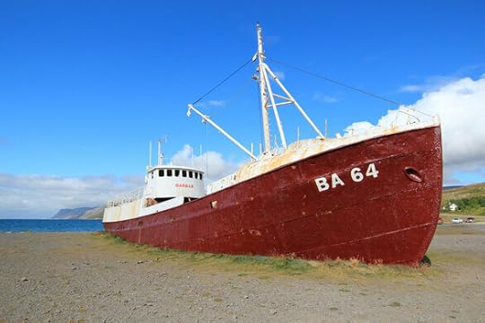
After decades in faithful service to its bevy of owners, Garðar BA 64 was finally deemed unsafe for service in 1981 and as opposed to being scuttled, the old ship was run aground in Skápadalur Valley where it remains to this day, falling apart bit by bit. It is now a popular site for photographers and anyone looking for a lovely mix of Icelandic scenery and industrial ruin.
 Clancy's comment: An old warrior laid to rest.
I'm...


February 26, 2022
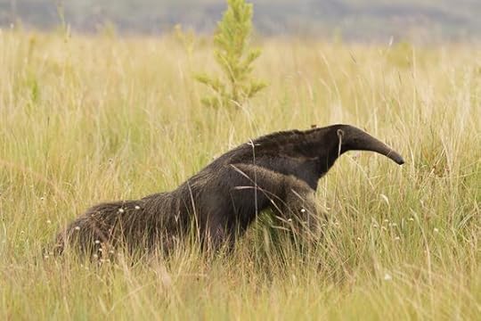
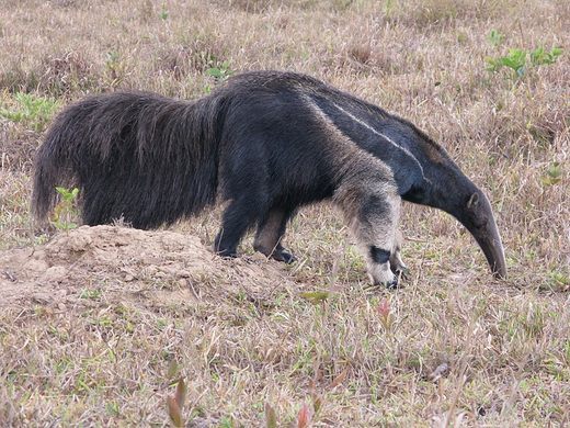
20 April 2022 - THE GIANT ANTEATERS OF BRAZIL
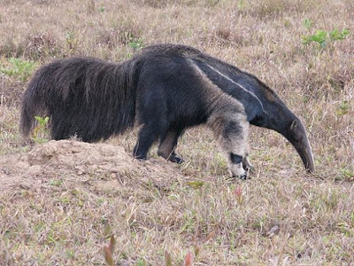
THE GIANT ANTEATERS
OF BRAZIL
G'day folks,
This breathtaking national park is one of the best places to see the weird and wonderful giant anteater in the wild.
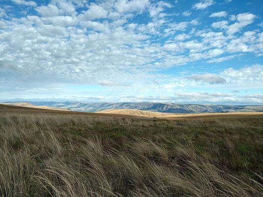
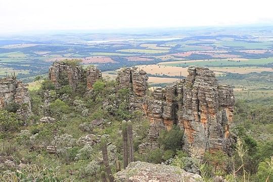
The wonderfully unique giant anteater is an endangered species that is disappearing from many regions of Brazil. But there are still wild areas where this strange species clings on to survival and can be seen easily. One of the best places in the country to observe these bizarre beasts is in the magnificent Serra da Canastra National Park in the state of Minas Gerais.
Serra Da Canastra has been a national park since 1972 and comprises an area of 72,000 acres of Cerrado savanna, hills, and forest, through which the São Francisco river flows. Highly biodiverse, over 350 species of animal live in the park and many rare and endangered plant species such as orchids are found here too. Still the real highlight of the park is undoubtedly its large mammal species, and especially the giant anteater.
This large creature may be seen very easily as it ambles on its knuckles through the long grass in search of its prey using its strange elongated snout to detect nearby anthills to raid. When visiting the park, you’re likely to see an anteater feed using its sharp claws to break open an anthill and its extraordinary long tongue to extract the insects. If you are really lucky, you may even see a mother anteater with her baby clinging to her back.
Other endangered species may also be observed here, such as the pampas deer, maned wolf, puma, pampas cat, rhea ostrich, giant armadillo, and the critically endangered Brazilian merganser duck. But these are much harder and more time-consuming to find than the anteater, and will typically make seasonal movements to less accessible areas of the reserve. (If you want to stand a good chance of seeing these creatures it’s best to plan the timing of your visit in advance with the animals’ seasonal behavior patterns in mind.)
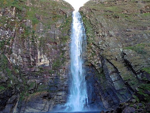
Serra Da Canastra is also an area of astounding landscapes with many trails to explore. A particularly famous natural landmark is the Casca D’Anta waterfall, which is over 610 feet tall and a renowned site of tranquility and enchanting natural beauty. The park is also home to many curious prehistoric rock formations that form eerie shapes. They are best seen at the Curral de Pedras and Garagem de Pedras sites.

Clancy's comment: Obviously a great place for wildlife photographers.
I'm ...


