
Clancy Tucker's Blog, page 20
April 27, 2022
18 June 2022 - MALTESE CATACOMB COMPLEXES
MALTESE CATACOMB
COMPLEXES
G'day folks,
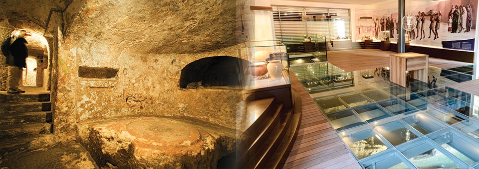
Burial grounds for more than 1,000 bodies are deep under the modern town of Rabat.From the 3rd to the 6th centuries CE, the Roman city of Melite developed a complex system of burial grounds on its outskirts under the modern town of Rabat, a village outside of Mdina, the medieval capital of Malta. Roman law prohibited burials within the city, which derives its name from the Arabic word for suburb.
Known today as the St. Paul and St. Agata catacombs, the burial grounds form an important part of Malta’s early Christian history. The catacombs include tombs for more than 1,000 bodies in 2,200 square meters.


The organizational and architectural complexity of the catacombs points to the ritual importance of burial grounds in early Christianity. The catacombs were planned in a centralized manner, providing private space for numerous family units, while leaving a lot of communal space for festivals and rituals. The entrance to the main complex of St. Paul’s leads to two large halls, adorned with pillars made to resemble Doric columns and painted plasters. The main hall is equipped with large circular tables and couches, carved out of rock. They were probably used during burial rituals and festivals of the dead. In some places the burial corridors were cut in three subterranean stories.
The catacombs were abandoned sometime in the 7th century during the later stages of the Byzantine Empire. They were reopened during the re-Christianization of the Island after 220 years of Fatimid rule. The catacombs became a popular site for religious pilgrimages in the 12th century and a Christian shrine was recut in the 13th century.
There are a number of smaller catacombs dating back to antiquity in Malta. One was rediscovered within a traffic roundabout close to the Malta International Airport in 2006. The Hal Resqun tomb was originally excavated in 1912. Soon after its discovery, the catacomb was covered up by a road surface, following the development of the Luqa Airfield.


April 26, 2022
15 June 2022 - THE WORLD'S LARGEST CAVE - VIETNAM

THE WORLD'S
LARGEST CAVE
- VIETNAM -
The world's largest cave was only discovered in 1991, and now offers tours to the public since 1991!!
Hang Son Doong — which roughly translates to Mountain River Cave — is the world’s largest cave and it is so large that it could hold a modern-day skyscraper inside of its caverns, and has its own small jungle.
Located near the Vietnam-Laos border, the cave was found by a local man named Ho-Khanh in 1991. The locals, it is said, were too afraid of the cave to go exploring because of the sound coming from the fast-moving underground river, as well as the huge vertical drop.


In 2009, a group of scientists from the British Cave Research Association began an extensive survey of the cave’s depths. According to Howard Limbert, the man leading the survey, the cave is five times larger than Phong Nha, which once held the title of the largest in Vietnam. The biggest chamber, his team found, is over five kilometers long and 200 meters tall.
The jungle found inside of the cave has formed underneath a collapsed roof in one of the caverns. After the roof collapsed, enough light spilled into the cavern that vegetation was able to creep in slowly from outside. As the vegetation took hold, larger and larger plants began to grow, and now hornbills, flying foxes, and monkeys dwell in its branches.
In 2013, public visits started to be offered by Oxalis that offer the chance to spend days inside exploring, as well as camping, in this massive cave.

17 June 2022 - THE WORLD'S LARGEST UNDERGROUND BUSINESS COMPLEX - MISSOURI

THE WORLD'S LARGEST
UNDERGROUND BUSINESS
COMPLEX in MISSOURI
G'day folks,
Welcome to the "World's Largest Underground Business Complex," a 55,000,000-square-foot city underneath Missouri.
There are a number of advantages to keeping things underground. The temperature remains near constant, energy costs are lowered, and—in the massive, 55,000,000-square-foot space known as Subtropolis—there is a whole city of workers who can keep your goods safe.
Subtropolis stores everything from a USPS collection of millions of postal stamps and the original film reels of Gone With the Wind, to a series of artificially lighted, manmade habitats used by Earth Works to demonstrate science to students.


Mining in SubTropolis began in the 1940s, and the empty space grew under the limestone bluffs on the Missouri River. By 1960, the owners realized that they had an enormous area they could rent out for business operations. The dubbed their underground city “SubTropolis” and called it “the World’s Largest Underground Business Complex,” a phrase that Hunt Midwest has trademarked. SubTropolis sports nearly seven miles of illuminated paved roads, and semi-trucks drive throughout the underground.
“We load and unload our trucks in perfect weather conditions,” said Joe Paris, co-founder and principal of Paris Brothers, a national specialty foods company headquartered in SubTropolis. “It’s truly a green environment. We’re probably using about 75 percent less electricity underground than we would in an above-ground facility. Whether it’s electronics or whether it’s food, you don’t have temperature and humidity fluctuations and so you don’t have any condensation, moisture building up in anything. From that standpoint, in my opinion you can’t beat it.”

April 25, 2022
11 June 2022 - 100,000 SOLDIERS OF TRABUC CAVES - FRANCE

100,000 SOLDIERS
OF TRABUC CAVES
- FRANCE -
G'day folks,
This army of concretions is an unexplained geological phenomenon unlike anything else in the world.There are countless caves around the globe, but the Trabuc Caves in southern France are unique among them all, due to a mysterious and stunning geological oddity known as the “100,000 Soldiers.”
This unexplained natural wonder stands out within the all-around beautiful Trabuc Caves, the largest network of underground passages in the Cévennes. Thousands upon thousands of strangely short concretions are clustered together in a small area; standing side by side, they resemble an enormous silent army of soldier figurines. The first explorers to come across this awesome site called it an army of 100,000 soldiers, and the name stuck.


This kind of geological formation has not been found anywhere else in the world. And still today, geologists don’t know how these formations were created. Stalagmites (on the ground) and stalactites (on the ceiling) are commonly found in pairs; the dripping water from the ceiling creates stalactites that fall to the ground and create stalagmites. But in the case of the 100,000 Soldiers, the concretions blanket the cave floor without any stalactites above. Scientists have posed theories over the years, but none ever sufficiently explained the geological anomaly. Its origin remains a scientific mystery to this day.
The splendor of the Trabuc Caves doesn’t stop at the 100,000 Soldiers. The network is adorned with a colorful rainbow of minerals, waterfalls, and pools, and it has a long and rich history. The caves have been known and used since antiquity, though it wasn’t until the 1950s that an artificial tunnel was dug allowing easy access into the cavern. The underground tunnels provided shelter for smugglers in the Middle Ages, and Huguenots during the religious wars in the 18th century. Scientific exploration of the caves started in 1823. By now, around six miles of caves have been explored, but speleologists expect the subterranean network to cover two or three times that size, as the limestone rock here is just an incredible maze.


13 June 2022 - STUNNING MILLAU VIADUCT - FRANCE

STUNNING
MILLAU VIADUCT
- FRANCE -
G'day folks,
The world's tallest bridge is also possibly the most elegant.Millau Viaduct is the world’s tallest bridge, a claim based on the height of the towers, which are taller than the Eiffel Tower. The height of the bridge deck itself is only the 17th tallest in the world, yet driving over it still feels like you’re literally in the clouds.


This cable stay bridge is on the E11, a popular motorway route between Calais and the French and Spanish Mediterranean coasts. It’s 890 feet from the road deck to the valley below, and the views are fantastic when it is not shrouded in cloud (which it commonly is).
The architects of this bridge have created a thing of wonder. How did anybody build it? In fact many of the engineering aspects of the bridge were already worked out before the architects were given the brief to make the bridge look so good. Building this bridge really was a team effort; the list of famous engineering companies involved is too long to include here. The story of the construction process is available widely but it is a great experience to read about at the visitor centre while enjoying an excellent view of the bridge itself.

April 23, 2022
6 June 2022 - GHOST TOWN COMING BACK TO LIFE

GHOST TOWN COMING
BACK TO LIFE
G'day folks,
Half a century after it was abandoned, this ghost town is coming back to life.
On the shores of the Salagou Lake, the ruins of the village of Celles are slowly coming back to life. In 1968, the village was emptied of its inhabitants to make way for the creation of the lake, which was going to rise to an altitude of 150 meters (492 feet), drowning the buildings. But plans changed, and the water never rose past 139 meter (456 feet) . Its inhabitants were kicked out for nothing.
The village was looted and squatted for several years, and the buildings fell into ruin. But after over 50 years, three new families signed leases to move back into Celles in September 2019 and begin the process of rebuilding.


The ruins are currently fenced off, but visitors can still walk through the village streets along the shores of the Salagou. The plan for rebuilding is ambitious. New residents were selected based on a business project or company that they will bring to the town, and being issued long-term leases designed to prevent real estate speculation. According to the terms of these leases, all tourist-facing business will take place in a single, communally run building. The town is also building social housing.
Celles is located in southeastern France, about 50 kilometers (30 miles) from the city of Montpellier. In the summer, the lake is a popular local destination for hiking and swimming. But Joëlle Goudal, the current mayor of Celles, wants to make sure that the village is first and foremost a place where people live, rather than a tourist attraction. “People were expropriated for this land,” she says. “It’s out of the question to let people today make money off of the people who were forced to leave.”

April 21, 2022
14 June 2022 - PARKSVILLE , NEW YORK - ONCE A THRIVING COMMUNITY

PARKSVILLE , NEW YORK
- ONCE A THRIVING COMMUNITY -
G'day folks,
This Central New York ghost town was once a prosperous railroad community.Located in the town of Liberty, New York, Parksville garnered substantial attention at the turn of the 20th century with the establishment of The Ontario & Western Railway (O&W). The O&W provided easy and direct transportation to the picturesque Catskill region, where the industry was booming and tycoons were building stately summer homes and hotels.
What was once a peaceful village became a bustling destination lined with high-end resorts and covetable shopping. But patrons would eventually lose interest in the O&W railroad in favor of the Hamptons and the Jersey Shore. Today, visitors to Parksville will find a quiet, withered town of mostly abandoned buildings.
Parksville’s origins can be traced back to the early 19th century when pioneering families from the New England area migrated to Sullivan County, New York. Among the earliest settlers was William Parks, who kickstarted the town’s industry by building mills and cultivating a community. Though Parks and his family were not the first to migrate to the hamlet since named Parksville—the Parksville Planning Committee lists Martin and Eber Hall as the first to have arrived—Parks’ lasting influence on the area bestowed on him the honor of the derivative name, Parksville.
Parksville attracted new residents who would continue to develop business in the region and form a small but prosperous community of merchants and mill workers. From the 19th and into the 20th century, the O&W railway line would facilitate the popularity and growth of the Catskills on a large scale, and until the Great Depression, Parksville was a preferred summer destination for city dwellers in search of a peaceful country escape.


Soon, Parksville would no longer be so peaceful. More than 100 hotels and resorts were built, and so many visitors flocked to Parksville that traffic jams in the town center were a regular sight. A number of the hotels closed their doors in the aftermath of the Great Depression, but the largest resorts—the Young’s Gap Hotel, the Prospect Inn, and the Grand Hotel, amongst a few others—remained in operation. In fact, the Young’s Gap, a beloved Parksville mainstay, would remain open into the 1960s, even through a steep decline in tourism with the steadily decreasing popularity of the O&W railway.
Route 17, a new highway that directed traffic through town, would briefly pique renewed interest in Parksville. In the late 80s and 90s, a group of local business owners tried to revive the town with a scattering of cafés, restaurants, and shops, but their success was short-lived. Route 17 became Interstate 86 which rerouted vehicles out of Parksville, so travelers had to make the town a pointed destination rather than it being an impromptu pitstop on their way through.
Today, Parksville is all but abandoned. While none of the original hotels, restaurants, or shops that once adorned the streets are still open, passersby can pay their respects to William Parks and his family, who are buried in the 19th century Baptist Church Cemetery.


Update as of December 2020: A restoration effort is underway at the site.
12 June 2022 - THE SITE OF THE WOODSTOCK FESTIVAL

THE SITE OF THE
WOODSTOCK FESTIVAL
G'day folks,
Welcome to the dairy farm in upstate New York where nearly half a million people gathered for three days of peace and music in 1969.
On August 15th, 16th, and 17th, 1969, an estimated 450,000 people from all over America descended on Max Yasgur’s 600-acre dairy farm in Bethel, New York, for the Woodstock Music and Art Fair. The festival was billed as “An Aquarian Exposition in White Lake, NY: 3 Days of Peace & Music.”
It is hard to overstate Woodstock’s legend. It has gone down in history for its epic musical performances, the mind-blowing size of the audience, countless logistical and technical challenges, traffic jams, drugs, rain, mud, occasional nudity, and the hippie ideals of peace and love. It was, above all, a joyful celebration that stands as the defining moment of the 1960s counterculture generation.


For those three days, some of the greatest musicians in the country descended upon this rural Catskills town (and notably not the town of Woodstock, New York, located nearby.) They included Richie Havens, Sweetwater, Tim Hardin, Ravi Shankar, Arlo Guthrie, Joan Baez, Carlos Santana, the Grateful Dead, Creedence Clearwater Revival, Janis Joplin, Sly and the Family Stone, The Who, Jefferson Airplane, Joe Cocker, The Band, Blood, Sweat and Tears, Crosby, Stills, Nash & Young, Sha Na Na, Jimi Hendrix, and many more.
Today, the historic music festival is marked with a small monument that offers a panoramic view of the original festival site. The site is adjacent to the Bethel Woods Center for the Arts, which contains the Museum at Bethel Woods, which features displays and artifacts related to the Woodstock festival and the 1960s counterculture that it came to represent.


Clancy's comment: Ah, those were the days ...
I'm ...

April 20, 2022
8 June 2022 - ELLENVILLE FAULT ICE CAVES - NEW YORK

ELLENVILLE
FAULT ICE CAVES
- NEW YORK -
G'day folks,
The largest known open fault in the United States is basically a giant natural refrigerator.Located high on the Shawangunk Ridge, the Ellenville Fault Ice Caves are the region’s natural air conditioner. Even in the dog days of summer, the ice caves at Sam’s Point are home to a thick layer of ice.


The ice caves are located within the Ellenville Fault, which is the largest known exposed fault system in the United States. The faults create deep crevices and small caverns, which are sheltered from the sun and outside environment, allowing temperatures to remain near or below freezing much of the year. This allows for ice to remain late in the summer and often until the next winter.
Interestingly, the caves act as a sort of natural refrigeration system for the surrounding area. While the top of the Shawangunk Ridge is only about 2,200 feet above sea level, the microclimate created by the ice caves has allowed plants that normally reside farther north and at much higher elevations to exist nearby. As such, there are large stands of northern and alpine plants such as black spruce and mountain ash.
In 1967, the ice caves were designated a national natural landmark by the National Parks Service, due to their unique geology and importance to the regional ecosystem. In the 1990s, the caves and nearby ridgetop were purchased by a non-profit, eventually becoming part of Minnewaska State Park in 2015. Since the 1990s, the caves have been restored to their natural appearance, with only ladders, railings, and solar-powered lights existing to ensure visitor safety.

April 19, 2022
10 June 2022 - THE ICE CAVE of BIXBY STATE PRESERVE

THE ICE CAVE
of
BIXBY STATE PRESERVE
G'day folks,
Chilly air billows out from the entrance of an abandoned mine on a steep hillside, providing a refuge for Ice Age fauna and flora.On a hot summer day, the ice cave at Bixby State Preserve in northeastern Iowa keeps its cool. Chilly air billows out of the cave mouth, once the entrance to a now-abandoned mine, courtesy of nature’s air conditioning. A rare combination of geological features at the site has allowed Ice Age flora and fauna to survive here for tens of thousands of years.
Over the millennia, water has eroded Bixby’s limestone, creating deeply-incised ravines, steep hillsides, sinkholes, and numerous smaller fractures in the rock. The “ice cave” gets its name from reserves of ice, deep inside the slope, that build up over the winter as water drips down into limestone’s many cracks and crevices. Air chilled by the ice seeps out through “ice vents” in the rocks. On north-facing hillsides that don’t receive direct sun, this phenomenon creates a microclimate that can be 40 degrees cooler than the ambient air in summer. The chill setting creates a refuge for plants and small animals that have lived in the area since at least the end of last Ice Age, nearly 20,000 years ago.


While the system that regulates the ice cave’s air flow is natural, the cave itself is partly artificial. Records are spotty—even Iowa’s Department of Natural Resources, which manages the site, isn’t sure about its past—but, more than a century ago, miners apparently enlarged a natural crack in the limestone to create the cave mouth we see today. Some sources say the passage extends about 80 feet into the hillside, but it’s unclear what, if anything, was ever mined there. The subterranean portion, now behind a metal barrier, is off-limits to would-be explorers.
Bixby earned its claim to scientific fame in the 1970s, when snail expert Allen Solum found a small population of Iowa Pleistocene snails (Discus macclintocki) present near the ice cave. While a tiny snail may not seem like a big deal, the animal was thought to be extinct for thousands of years: It’s one of the Ice Age-era species that persists at Bixby thanks to the microclimate created by the ice vents.
The snails, which are endangered, and several of the plants and other small animals on Bixby’s steep slopes are extremely fragile. Visitors must stay on established paths when visiting the preserve. Don’t go hunting for the snails, either. They’re hard to spot and, quite frankly, not much to look at. Just a quarter-inch in diameter, the dull-colored snails also lay their eggs on leaf litter. Just one footstep can wipe out an entire population.
The ice cave isn’t the only reason to visit the 184-acre preserve. Bixby State Preserve includes a trout stream, small picnic area, and a few quiet, pleasant trails. The preserve exists thanks to late-19th century local R. J. Bixby, who recognized the area’s natural beauty and began buying parcels to protect it from development.


