
Clancy Tucker's Blog, page 10
July 19, 2022
6 October 2022 - ANCIENT PETROGLYPHS IN UTAH, USA

ANCIENT PETROGLYPHS
IN UTAH, USA
G'day folks,
Welcome to a unique collection of drawings that represent Fremont Native American culture.
These beautifully preserved petroglyphs are just north of Vernal, at McConkie Ranch in Dry Fork Canyon. These panels cover 200 feet along a cliff face in the Navajo formation. It’s believed the petroglyphs were crafted somewhere between 1-1200 CE. They are excellent examples of Fremont Native American culture.


The images include various people and symbols along with large renditions of the various animals that populated the region. Many are also numbered, detailing where various archaeologists have worked across the site.
The petroglyphs can be easily reached by several trails with signs and ropes that mark the way. The trails are easy to traverse. The entire trek is just over a mile hike roundtrip.


July 17, 2022
17 October 2022 - ELTHAM TOY WALL - NEW ZEALAND

ELTHAM TOY WALL
- NEW ZEALAND -
G'day folks,
What began as a makeshift lost and found, now exists as a unique art installation.This quirky little attraction in the town of Eltham in Taranaki began in the 1970s. That’s when local resident Faye Young discovered a few discarded toys in the neighboring Bridger Park.


Instead of leaving the toys discarded about the park, she placed them in a nearby wall between her house and the park. Young hoped that the toy’s owners would be able to easily find their items at the wall. Instead, more toys appeared in the crevices of the wall. Mrs. Young and her family decided to cement the toys into the wall, creating a permanent wall of toys. Now, thousands of toys can be found along the wall to be enjoyed by visitors both young and old.
5 October 2022 - THE BRIDGE TO NOWHERE - NEW ZEALAND

THE BRIDGE TO
NOWHERE
- NEW ZEALAND -
G'day folks,
This bridge was designed to connect a road that never came to fruition.Deep in the forest of Whanganui National Park is the “valley of abandoned dreams,” and a lone concrete bridge.


Though only accessible by boat up the Whanganui River, the first pioneers in the area believed that eventually, a road would link to the valley. They constructed the bridge in anticipation, but the road was never developed.
Left isolated, they faced a lonely wilderness too difficult to tame. Today, the area is abandoned but the Bridge to Nowhere still stands as a symbol of the ill-fated settlement.

July 15, 2022
13 October 2022 - EDSTONE AQUEDUCT - ENGLAND

EDSTONE AQUEDUCT
- ENGLAND -
G'day folks,
The longest canal aqueduct in England was built without a plan to get water past the moving boats.Built in 1816 to carry the Stratford-upon-Avon Canal, the Edstone Aqueduct is the longest canal aqueduct in England (although there are longer ones in both Scotland and Wales and a number of higher ones too). It is 475 feet long and 33 feet high at its highest point. The engineer was William Whitmore.
It crosses a minor road, a stream, a live railway line (formerly the Birmingham, North Warwickshire and Stratford Railway) and a disused railway line (the former Alcester railway later taken into the Great Western Railway). Both railways lines post date the aqueduct by many years and took advantage of the existing structure.


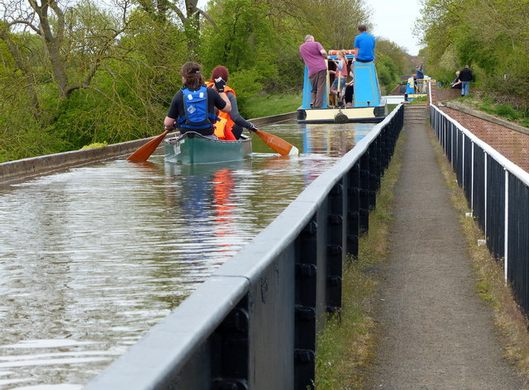

The canal is carried in iron troughs supported on brick pillars. The troughs were constructed by bolting together 14-foot by five-foot flanged cast iron plates. It is possible to walk across the aqueduct on the towpath which has parapet alongside it (and is at the level of the base of the trough) but if on a boat there is no parapet on the canal side and the water comes very close to the top of the trough. The trough is too narrow to allow boats to pass without building up a bow wave in front and for horse drawn boats this created a distinct barrier to the passage across the viaduct. Later cast iron viaduct designs benefited from the experience of this example.
There are two more similar, but shorter, iron trough type aqueducts on this four-mile stretch of the canal. The Great Western Railway owned the aqueduct for a time and they fitted a pipe to the trough to allow water to be withdrawn to fill up steam locomotives below.
July 14, 2022
16 October 2022 - DICK'S LANE SPLIT BRIDGE - ENGLAND

DICK'S LANE
SPLIT BRIDGE
- ENGLAND -
G'day folks,
Here is a great example of the inventive canal bridges that were deliberately split down the middle.When the South Stratford Canal was being built between 1813 and 1816, financial difficulties resulted in some innovative cost-saving measures. Among these were the characteristic split bridges.


These were made of cast iron and two separate cantilevered decks projected from each side of the canal, from brick and stone abutments. A narrow gap was left down the middle. The horse-drawn narrow boats using the canal would approach the bridge and the horse would walk round the outside while a crew member fed the tow rope down the slot in the middle. This innovative idea allowed the boat to pass without unhitching the rope.
This saved a lot of money since, as well as allowing pre-fabrication, the bridge did not have to be wide enough to have a tow path under it. These were “accommodation bridges,” built to maintain an existing right of way when the canal was built and had to be built at the expense of the canal company. They were not capable of carrying heavy loads but were adequate for their purpose.
There are several examples of this type of bridge on the South Stratford Canal. Dick’s Lane Bridge is one of the best preserved and illustrates the inventiveness of the 18th- and 19th-century canal builders.


12 October 2022 - BILTMORE ESTATE'S SECRET PASSAGEWAYS

BILTMORE ESTATE'S
SECRET PASSAGEWAYS
G'day folks,
The enormous 250-room Vanderbilt mansion conceals hidden doors and secret passageways.With 35 bedrooms, 43 bathrooms, 65 fireplaces, and nearly 180,000 square feet, the enormous Biltmore Estate has plenty of places to hide.
The Biltmore Estate was built as the ultimate indulgence of George Washington Vanderbilt II, a descendant of Cornelius “The Commodore” Vanderbilt, the builder of Grand Central Terminal in New York City and a pioneer of the Gilded Age in America. It was designed with several concealed doors, hidden passageways, and secret rooms, which blend in seamlessly with the decor so that they are not noticeable to the untrained eye.


In the late 19th century, these behind-the-scenes spaces were used to provide the Vanderbilts and their guests with some added privacy or to conceal the movement of servants moving in and out of the mansion’s common spaces.
In the Breakfast Room, the mansion’s “informal” dining room, there is a camouflaged door hidden in the wall behind the table. It leads to the butler’s pantry, which servants would slip in and out of while carrying meals. You can just make out the door frame behind the two Renoir paintings that hang on the wall. A doorknob sticks out below the right-hand corner of Renoir’s Child with an Orange.


The estate’s massive library, apart from being a bibliophile’s dream, also houses a secret passageway that leads to the guest bedrooms. A balcony wraps around the second story of the library, and on it are two doors to the hidden hall. The library also hides a tiny room known as the “Den.” The easily missed door is obscured by a carving of St. Peter the Martyr. It leads to a mysterious room that may have been used as a quiet place to read and write, a special little oasis within the giant home.
Another hidden space is found in the Billiard Room. A wooden door beside the fireplace leads to the Smoking Room, where the men would retire for brandy and cigars. Additional hidden treasures include a trap door in the floor of the Winter Garden (where tropical plants were housed in the wintertime), and a concealed closet in Vanderbilt’s own bedroom, decorated to blend in with the rest of the wall so as to not disrupt the careful decor.


The estate also boasts one underground tunnel in Antler Hill Village (located three miles from the house) that used to be part of the Biltmore Dairy Barn. The stone tunnel leads to a winery.
July 12, 2022
11 October 2022 - MALTESE CATACOMB COMPLEXES

MALTESE CATACOMB
COMPLEXES
G'day folks,
Burial grounds for more than 1,000 bodies exist deep under the modern town of Rabat.From the 3rd to the 6th centuries, the Roman city of Melite developed a complex system of burial grounds on its outskirts under the modern town of Rabat, a village outside of Mdina, the medieval capital of Malta. Roman law prohibited burials within the city, which derives its name from the Arabic word for suburb.
Known today as St. Paul’s and St. Agatha’s catacombs, the burial grounds form an important part of Malta’s early Christian history. The catacombs include tombs for more than 1,000 bodies in 2,200 square meters.


The organizational and architectural complexity of the catacombs points to the ritual importance of burial grounds in early Christianity. The catacombs were planned in a centralized manner, providing private space for numerous family units, while leaving a lot of communal space for festivals and rituals. The entrance to the main complex of St. Paul’s leads to two large halls, adorned with pillars made to resemble Doric columns and painted plasters. The main hall is equipped with large circular tables and couches, carved out of rock. They were probably used during burial rituals and festivals of the dead. In some places the burial corridors were cut in three subterranean stories.
The catacombs were abandoned sometime in the 7th century during the later stages of the Byzantine Empire. They were reopened during the re-Christianization of the Island after 220 years of Fatimid rule. The catacombs became a popular site for religious pilgrimages in the 12th century and a Christian shrine was recut in the 13th century.


There are a number of smaller catacombs dating back to antiquity in Malta. One was rediscovered within a traffic roundabout close to the Malta International Airport in 2006. The Hal Resqun tomb was originally excavated in 1912. Soon after its discovery, the catacomb was covered up by a road surface, following the development of the Luqa Airfield.
3 October 2022 - CARACOL - ANCIENT MAYA SITE IN BELIZE

CARACOL
- ANCIENT MAYA
SITE IN BELIZE -
G'day folks,
This massive Maya archaeological site is home to the tallest man-made structure in Belize.The road begins near San Ignacio, a rugged town in western Belize not far from the Guatemalan border. About three hours down a winding, muddy jungle road and you’ll enter the site of Caracol, a vast, ancient Mayan city that thrived for 300 years and, at its peak, covered nearly 77 square miles (200 sq km)—larger than Belize City today.
Even at its busiest, you won’t find crowds of tourists at Caracol. Although it is located only about 50 miles (75 km) from Tikal, the site at Caracol remains less visited, perhaps due to its relative inaccessibility and more recent archaeological interest.


Caracol was rediscovered in 1937, when a native logger named Rosa Mai came across its remains while searching for mahogany in the area. The site was surveyed the following year, but more significant investigation did not begin until 1985, when the Caracol Archaeological Project was established.
The site—which is only partially uncovered—includes several plazas, acropolises, and residential areas, along with many altars and stelae. More than 250 burials and 200 caches have been discovered at the site so far. The largest building, Caana (“sky palace”), remains the tallest human-made structure in Belize at 141 feet tall (43 m).


Archaeological evidence suggests that Caracol was an important Maya site that was occupied continuously from 600 B.C. to 1100 A.D. The city was at its largest and densest during the Late Classic Period, around 650. At its height, the population of Caracol is thought to be around 100,000 or more, easily exceeding Tikal’s peak population. But 300-400 years later, the central metropolis was mostly abandoned.
The name Caracol means “snail,” apparently in reference to the twisted road used to approach the site.
July 11, 2022
2 October 2022 - THE MOVING ISLAND - ITALY

THE MOVING ISLAND
- ITALY -
G'day folks,
This serene, turquoise lake in an extraordinary nature reserve showcases a rare natural phenomenon.Posta Fibreno is a karstic lake in the foothills of Italy’s Lazio region, and though it may seem more like an engrossed river, it is a small, serene lake home to a very unusual natural phenomenon known since Roman times. Described by Pliny the Elder in his 1st-century Naturalis Historia, the lake is the setting for the subtle dances and movements of a natural floating island.


The island, known as La Rota for its round shape, was formed over the years by free-floating rhizomes, peat, and roots. At about 13 feet thick and 130 feet wide, the mass is not rooted to the ground below the water, and thus the wind and currents cause it to move freely around the surface of the lake. Small trees and shrubs cover the land, and when a breeze blows or the volume of the water released by the underwater springs varies, the island appears to be somehow floating around on its own. This is a phenomenon so rare that Posta Fibreno is one of the only places on Earth to see it occur.
Geological anomaly aside, Lake Posta Fibreno’s mild temperature and extraordinarily clear waters have made it a paradise for divers, kayakers, wildlife lovers, and birdwatchers. The landscape is a nature reserve that protects a local endemic species of fish, the Fibreno trout. The lake has no tributaries and it is fed by karstic springs, whose constant flow are responsible for the turquoise water’s remarkable transparent hue. The fishermen on Posta Fibreno still use a traditional boat known locally as a “nàue,” and these may be spotted when walking along the nature reserve’s boardwalks.


July 10, 2022
1 October 2022 - MYSTERIOUS KAINDY LAKE - KAZAKHSTAN

MYSTERIOUS
KAINDY LAKE
- KAZAKHSTAN -
G'day folks,
Here, submerged trees jut ghost-like out of an idyllic turquoise mountain lake.
Kaindy Lake is an idyllic mountain lake in Kazakhstan’s portion of the Tian Shan Mountains, close to the country’s largest city, Almaty. The lake was formed after an earthquake in 1911, which caused a major landslide, effectively creating a natural dam. Successively, rainwater filled the valley and created the lake.
The lake is famous for the number of dead and bleached spruce trees that stick out of the water – remnants of the trees that were flooded when the lake was formed. The trees, together with the improbable turquoise water of the lake, make an incredibly scenic sight. Underwater, the imagery is even more stunning, as the trees have not decomposed and create the surreal vision of an underwater forest.


Surprisingly, the lake sees few visitors, partly because Kaindy Lake is overshadowed by the more famous Bolshoe Almatinskoe Lake and the Kolsay Lakes, all of which are close by, but far easier to reach from Almaty. Thus, despite its proximity to a city with a population of more than one million, the lake retains a peaceful atmosphere.


