
Jeffrey E.F. Friedl's Blog, page 3
November 29, 2018
Valerie Wigglegram at the Eigenji Temple
Note: this article may not appear properly in news readers.
This article contains interactive aspects that are likely removed by most news readers. Please see this particular article directly on Jeffrey's blog for full functionality.
div#djKHaPQQeQQeCdA img { width:466px; height:700px; visibility:hidden; position:absolute; top:0; left:0; border: solid 10px #311}


Animatable Wigglegram (23 frames) — slowly sweep mouse from side to side to view 3D effect
写真の上をマウスで左右にゆっくり動かすと「3D」な感じが出ます。
=i.length)return 0;else return which;}else{if(which=i.length)return i.length-1;else return which}};t=function(event){if(m>0&&((new Date().getTime())-m)R&&s0){f(c(s-1));console.log(s+":delta is "+delta);L=0.05;R=0.2;T=tilt;}}};d.ontouchmove=d.onmousemove=function(e){if(e.touches&&e.touches.length>1)return true;var x=Math.floor((e.clientX||e.pageX)/BW);var which=c(x>l?s+(x-l):s-(l-x));l=x;if(which!=s){m=new Date().getTime();f(which);}return false;};window.addEventListener('devicemotion',t,false)}
Here's a wigglegram of Taiwan-based photographer
Valerie Roche near the back entrance to the Eigenji Temple (永源寺) in Shiga Prefecture, from the outing earlier in the month
touched on in “A Peek at Not-Yet-Peak Autumn Colors in Japan, To Pique Your Interest”.
If the location seems familiar, it's perhaps because of a wigglegram of Paul Barr in the same place, two years ago, appearing in
“The Back Entrance to Shiga’s Eigenji Temple”.
It's such a photogenic temple in autumn, I have to show from that trip for a
dozen more postgs, but sadly I got around to only “Rear Courtyard at the Eigenji Temple”
and “Anatomy of a
Selfie”.


November 21, 2018
A Peek at Not-Yet-Peak Autumn Colors in Japan, To Pique Your Interest
Nikon D4 + Nikkor 24-70mm f/2.8 @ 60mm — 1/400 sec, f/2.8, ISO 1600 —
map & image data — nearby photos
Middle of Nowhere
Patrick, Damien, and Valerie
in Shiga Prefecture, Japan
One reason that I don't blog so much these days is that when I do go out with the camera, the places I visit are so
overwhelmingly beautiful that I get choice paralysis in deciding what to work on, and what to write about. I start to work on one
set of photos, only to get drawn into a hundred side channels for things I want to share, and in the end I share nothing because
nothing finds its way all the way to a blog post.
So with the intent to fight agsinst that, I set out this morning to quickly scan the 714 photos I took during a recent outing
to some temples in Shiga Prefecture (an hour's drive from Kyoto), and quickly choose a few photos and blog them. What I had hoped
would take 30 minutes has, to this point, taken two hours.
Nikon D4 + Voigtländer 125mm f/2.5 — 1/50 sec, f/2.5, ISO 100 —
map & image data — nearby photos
Comparing Camera Settings
at the Eigenji Temple (永源寺)
Part of the slowness comes from my desire to tie in today's photos with ones from the past. This helps make my blog a diary for my own consumption later in life, I guess, when my memory starts to.... what was I talking about? 
November 14, 2018
Kyoto’s 2018 Fall Foliage Season is Upon Us
Nikon D4 + Nikkor 24-70mm f/2.8 @ 42mm — 1/200 sec, f/2.8, ISO 2500 —
map & image data — nearby photos
Quick Portrait at the Sanzen-in Temple
三千院、Kyoto Japan
The fall colors starting to descend upon Kyoto has woken me up, at least momentarily, from an almost-two-month blogging slumber.
Friends Paul and Olesia are visiting, Paul for the 100th time, Olesia for the first, so we took her up to the Ohara area of Kyoto,
in the north-eastern mountains, for the first taste of autumn colors.
Walking up from the parking area toward the temples, the path is lined with tasteful shops. Here's a little kiosk selling
only autumn-color handkerchiefs:
Nikon D4 + Nikkor 24-70mm f/2.8 @ 36mm — 1/160 sec, f/2.8, ISO 1400 —
map & image data — nearby photos
Nikon D4 + Nikkor 24-70mm f/2.8 @ 34mm — 1/200 sec, f/2.8, ISO 5600 —
map & image data — nearby photos
Symbol of the Area
apparently
Nikon D4 + Nikkor 24-70mm f/2.8 @ 38mm — 1/160 sec, f/2.8, ISO 560 —
map & image data — nearby photos
A Few Colors
Nikon D4 + Nikkor 24-70mm f/2.8 @ 32mm — 1/125 sec, f/2.8, ISO 5000 —
map & image data — nearby photos
Cucumber on a Stick
Nikon D4 + Nikkor 24-70mm f/2.8 @ 56mm — 1/250 sec, f/2.8, ISO 4000 —
map & image data — nearby photos
Nikon D4 + Nikkor 24-70mm f/2.8 @ 38mm — 1/160 sec, f/2.8, ISO 900 —
map & image data — nearby photos
Nice Tree
near the entrance to the Sanzen-in Temple (三千院)
Nikon D4 + Nikkor 24-70mm f/2.8 @ 45mm — 1/200 sec, f/2.8, ISO 800 —
map & image data — nearby photos
Nikon D4 + Nikkor 24-70mm f/2.8 @ 38mm — 1/160 sec, f/2.8, ISO 900 —
map & image data — nearby photos
Main Garden
few colors yet, besides green
Nikon D4 + Nikkor 70-200mm f/2.8 @ 120mm — 1/500 sec, f/2.8, ISO 2500 —
map & image data — nearby photos
Green-Tea Instagram Moment
Nikon D4 + Nikkor 24-70mm f/2.8 @ 24mm — 1/100 sec, f/5, ISO 6400 —
map & image data — nearby photos
Hallway with Nice Light
Nikon D4 + Nikkor 24-70mm f/2.8 @ 24mm — 1/100 sec, f/5, ISO 1100 —
map & image data — nearby photos
Another Way
to enjoy the main garden
(10 minutes later, she tracked me down and asked for copies of the photos)
Nikon D4 + Nikkor 24-70mm f/2.8 @ 24mm — 1/100 sec, f/6.3, ISO 3600 —
map & image data — nearby photos
This Tree Can't Decide
what color to be
Nikon D4 + Nikkor 24-70mm f/2.8 @ 44mm — 1/200 sec, f/2.8, ISO 3200 —
map & image data — nearby photos
Olesia
iPhone 6 — 1/30 sec, f/2.2, ISO 40 —
map & image data — nearby photos
Me
photo by Olesia
Nikon D4 + Nikkor 24-70mm f/2.8 @ 38mm — 1/160 sec, f/2.8, ISO 3200 —
map & image data — nearby photos
Nice Detail
Nikon D4 + Nikkor 24-70mm f/2.8 @ 24mm — 1/100 sec, f/2.8, ISO 1600 —
map & image data — nearby photos
“Secret Path”
that's not secret; I had simply never noticed it.
Nikon D4 + Nikkor 24-70mm f/2.8 @ 24mm — 1/100 sec, f/2.8, ISO 1100 —
map & image data — nearby photos
Nice Place for a Portrait
Nikon D4 + Nikkor 70-200mm f/2.8 @ 125mm — 1/320 sec, f/2.8, ISO 6400 —
map & image data — nearby photos
Slumbering Jizo
Nikon D4 + Nikkor 24-70mm f/2.8 @ 24mm — 1/100 sec, f/2.8, ISO 2000 —
map & image data — nearby photos
Nikon D4 + Nikkor 24-70mm f/2.8 @ 48mm — 1/200 sec, f/2.8, ISO 2500 —
map & image data — nearby photos
Photographers are Suckers
for moss
Nikon D4 + Nikkor 24-70mm f/2.8 @ 29mm — 1/125 sec, f/2.8, ISO 1100 —
map & image data — nearby photos
Fading Light
Nikon D4 + Nikkor 24-70mm f/2.8 @ 50mm — 1/200 sec, f/2.8, ISO 1600 —
map & image data — nearby photos
Nikon D4 + Nikkor 24-70mm f/2.8 @ 32mm — 1/125 sec, f/2.8, ISO 3200 —
map & image data — nearby photos
Just Peeking
Hosen-in Temple (宝泉院)
Nikon D4 + Nikkor 24-70mm f/2.8 @ 70mm — 1/320 sec, f/2.8, ISO 4000 —
map & image data — nearby photos
Nikon D4 + Nikkor 24-70mm f/2.8 @ 24mm — 1/100 sec, f/2.8, ISO 2000 —
map & image data — nearby photos
Dressing (as in salad) Shop
On the way in, we stopped by a shop that gave taste samples of their various dressings and ponzu.
They were all good, but two of them were “wow!”, so we stopped on the way back to get some.
Nikon D4 + Nikkor 24-70mm f/2.8 @ 26mm — 1/200 sec, f/2.8, ISO 1000 —
map & image data — nearby photos
Many Kinds
Nikon D4 + Nikkor 24-70mm f/2.8 @ 24mm — 1/100 sec, f/2.8, ISO 1000 —
map & image data — nearby photos
Onion & Garlic
I also picked up a bottle of aka shiso flavor (red shiso). Really crisp and nice.
Nikon D4 + Nikkor 24-70mm f/2.8 @ 38mm — 1/160 sec, f/2.8, ISO 3200 —
map & image data — nearby photos
Field of Rape
The area used to produce a lot of rapeseed oil (also known as “canola oil”)
We too the long way home to drive through some of the deep mountain roads that I cycle on.
When in the forest it was quite dark. In this photo below, it was actually much darker than
it seems (I took a longer exposure than normal). Handheld for 1/13th second. It came out okay.
Nikon D4 + Nikkor 24-70mm f/2.8 @ 24mm — 1/13 sec, f/2.8, ISO 6400 —
map & image data — nearby photos
Much Brighter than Reality
near Momoi Pass (百井峠)
The “warm glow from the setting sun” look is from the car's hazard lights.
September 20, 2018
Surveying Supertyphoon Jebi’s Damage North of Kyoto, Part 2
Today's post is a continuation of
“SUPER FUN!! Cycling in Supertyphoon Jebi”
and its followup,
“Surveying Supertyphoon Jebi’s Damage North of Kyoto, Part 1”.
At the end of the previous post, we'd come across a fallen utility pole, as we had a few times earlier....
Panasonic LX100 at an effective 24mm — 1/200 sec, f/5.6, ISO 200 —
map & image data — nearby photos
2:40pm
Panasonic LX100 at an effective 24mm — 1/125 sec, f/4, ISO 200 —
map & image data — nearby photos
“Caution”
the small sign at left is normally high up in the air, alerting to overhead wires
The photo above is looking back toward where we'd come from, and in it there's a farmer leaning against a truck in front of his house. He'd told me that the road was not passable even by foot, but I'd dismissed it as an exaggeration. I shouldn't have.
What follows are a bunch of photos in chronological order, documenting what we came across....
Panasonic LX100 at an effective 34mm — 1/125 sec, f/4.5, ISO 200 —
map & image data — nearby photos
2:40pm
Panasonic LX100 at an effective 34mm — 1/125 sec, f/2.3, ISO 250 —
map & image data — nearby photos
Can Barely See the Road
2:41pm
Panasonic LX100 at an effective 28mm — 1/125 sec, f/2.2, ISO 200 —
map & image data — nearby photos
Can Not See The Road
2:41pm
Panasonic LX100 at an effective 28mm — 1/125 sec, f/2.1, ISO 200 —
map & image data — nearby photos
2:42pm
Panasonic LX100 at an effective 28mm — 1/125 sec, f/2.1, ISO 200 —
map & image data — nearby photos
Still No Road
2:43pm
Panasonic LX100 at an effective 28mm — 1/125 sec, f/2.5, ISO 200 —
map & image data — nearby photos
2:44pm
photo by Joshua Levine
Panasonic LX100 at an effective 24mm — 1/125 sec, f/1.7, ISO 640 —
map & image data — nearby photos
2:48pm
Panasonic LX100 at an effective 44mm — 1/100 sec, f/2.6, ISO 1250 —
map & image data — nearby photos
2:48pm
Panasonic LX100 at an effective 50mm — 1/125 sec, f/2.7, ISO 1000 —
map & image data — nearby photos
2:49pm
Panasonic LX100 at an effective 24mm — 1/125 sec, f/1.7, ISO 640 —
map & image data — nearby photos
2:50pm
Panasonic LX100 at an effective 24mm — 1/125 sec, f/1.7, ISO 640 —
map & image data — nearby photos
2:50pm
Panasonic LX100 at an effective 28mm — 1/125 sec, f/2.1, ISO 250 —
map & image data — nearby photos
Lucky Car
2:51pm
Panasonic LX100 at an effective 41mm — 1/125 sec, f/4, ISO 200 —
map & image data — nearby photos
2:52pm
Panasonic LX100 at an effective 28mm — 1/125 sec, f/2.1, ISO 400 —
map & image data — nearby photos
2:54pm
Panasonic LX100 at an effective 24mm — 1/125 sec, f/5, ISO 200 —
map & image data — nearby photos
This Section Was Difficult
2:57pm
This section that I had just come over was difficult, because not only was the road not visible, we were walking
on branches that were well above the guardrail, itself not visible unless your foot fell through the web of branches and
made a hole to look down and see it. The only path I could find was right over the guardrail at the edge of the cliff, so
if you slipped in an unlucky way, you'd slice your foot on the top of the guardrail, or tumble down into the river.
At this point we met two workers walking from the other direction, and they helped John and Joshua with their bikes.
Panasonic LX100 at an effective 25mm — 1/125 sec, f/5, ISO 200 —
map & image data — nearby photos
Helping Hand
2:57pm
They said that they had been walking for an hour, and that there were maybe six or seven more almost-impassable sections like the one
we were on. It turns out that this was wildly underestimated.
Panasonic LX100 at an effective 25mm — 1/125 sec, f/1.8, ISO 250 —
map & image data — nearby photos
Easy Section
2:58pm
Panasonic LX100 at an effective 25mm — 1/200 sec, f/5.6, ISO 200 —
map & image data — nearby photos
Actually Riding
2:59pm
Panasonic LX100 at an effective 25mm — 1/125 sec, f/1.8, ISO 250 —
map & image data — nearby photos
2:59pm
Panasonic LX100 at an effective 25mm — 1/125 sec, f/2.5, ISO 200 —
map & image data — nearby photos
3:00pm
Panasonic LX100 at an effective 25mm — 1/125 sec, f/2, ISO 200 —
map & image data — nearby photos
3:01pm
Panasonic LX100 at an effective 25mm — 1/125 sec, f/3.2, ISO 200 —
map & image data — nearby photos
3:01pm
Panasonic LX100 at an effective 25mm — 1/250 sec, f/5.6, ISO 200 —
map & image data — nearby photos
3:02pm
Panasonic LX100 at an effective 25mm — 1/160 sec, f/5.6, ISO 200 —
map & image data — nearby photos
3:02pm
Panasonic LX100 at an effective 25mm — 1/125 sec, f/3.2, ISO 200 —
map & image data — nearby photos
3:04pm
Panasonic LX100 at an effective 24mm — 1/125 sec, f/5, ISO 200 —
map & image data — nearby photos
Smooth Sailing
3:05pm
Panasonic LX100 at an effective 24mm — 1/125 sec, f/2.8, ISO 200 —
map & image data — nearby photos
Old and New
3:07pm
I'm guessing that the cut trees in the photo above are part of the
massive damage from last year's Typhoon #21. The fallen utility pole and
the slight landslide are from this year.
Panasonic LX100 at an effective 24mm — 1/125 sec, f/3.2, ISO 200 —
map & image data — nearby photos
3:08pm
iPhone 7+ — 1/200 sec, f/1.8, ISO 20 —
map & image data — nearby photos
3:08pm
Panasonic LX100 at an effective 24mm — 1/125 sec, f/4.5, ISO 200 —
map & image data — nearby photos
Stripped
This tree had its bark stripped clean in parts
3:09pm
Panasonic LX100 at an effective 47mm — 1/125 sec, f/3.5, ISO 200 —
map & image data — nearby photos
3:09pm
Panasonic LX100 at an effective 24mm — 1/250 sec, f/5.6, ISO 200 —
map & image data — nearby photos
3:10pm
At times we faced such a daunting task to get past a section, we thought to turn back. But we knew how tough it would be to retrace our steps,
and imagined that it couldn't be that bad going forward.
We were wrong.
Panasonic LX100 at an effective 24mm — 1/125 sec, f/3.2, ISO 200 —
map & image data — nearby photos
3:13pm
Panasonic LX100 at an effective 30mm — 1/125 sec, f/2.2, ISO 250 —
map & image data — nearby photos
3:14pm
Panasonic LX100 at an effective 30mm — 1/125 sec, f/2.2, ISO 200 —
map & image data — nearby photos
3:16pm
Panasonic LX100 at an effective 24mm — 1/125 sec, f/5, ISO 200 —
map & image data — nearby photos
3:18pm
Panasonic LX100 at an effective 24mm — 1/200 sec, f/5.6, ISO 200 —
map & image data — nearby photos
3:18pm
Panasonic LX100 at an effective 24mm — 1/200 sec, f/5.6, ISO 200 —
map & image data — nearby photos
3:19pm
Panasonic LX100 at an effective 50mm — 1/200 sec, f/5.6, ISO 200 —
map & image data — nearby photos
Mountainside Raped by the Wind
3:21pm
iPhone 7+ + iPhone 7 Plus back dual camera 3.99mm f/1.8 at an effective 28mm — 1/750 sec, f/1.8, ISO 20 —
map & image data — nearby photos
This is the Road
3:22pm
Panasonic LX100 at an effective 41mm — 1/125 sec, f/4.5, ISO 200 —
map & image data — nearby photos
3:24pm
Panasonic LX100 at an effective 24mm — 1/125 sec, f/4.5, ISO 200 —
map & image data — nearby photos
Passing Through
in some sections we could get by only by passing the bikes separately
3:27pm
Panasonic LX100 at an effective 24mm — 1/125 sec, f/5, ISO 200 —
map & image data — nearby photos
3:30pm
Panasonic LX100 at an effective 24mm — 1/160 sec, f/5.6, ISO 200 —
map & image data — nearby photos
3:30pm
Panasonic LX100 at an effective 24mm — 1/250 sec, f/5.6, ISO 200 —
map & image data — nearby photos
3:30pm
Panasonic LX100 at an effective 24mm — 1/125 sec, f/5.6, ISO 200 —
map & image data — nearby photos
3:32pm
Panasonic LX100 at an effective 24mm — 1/125 sec, f/5.6, ISO 200 —
map & image data — nearby photos
3:32pm
Panasonic LX100 at an effective 24mm — 1/125 sec, f/5, ISO 200 —
map & image data — nearby photos
3:39pm
Panasonic LX100 at an effective 24mm — 1/125 sec, f/2, ISO 200 —
map & image data — nearby photos
3:40pm
Panasonic LX100 at an effective 24mm — 1/125 sec, f/2.5, ISO 200 —
map & image data — nearby photos
3:41pm
Panasonic LX100 at an effective 46mm — 1/100 sec, f/2.6, ISO 200 —
map & image data — nearby photos
3:41pm
Panasonic LX100 at an effective 75mm — 1/125 sec, f/2.8, ISO 250 —
map & image data — nearby photos
Oops
3:42pm
Panasonic LX100 at an effective 25mm — 1/125 sec, f/2.5, ISO 200 —
map & image data — nearby photos
3:42pm
Panasonic LX100 at an effective 24mm — 1/125 sec, f/2.2, ISO 200 —
map & image data — nearby photos
Low Ceiling
3:42pm
Panasonic LX100 at an effective 24mm — 1/125 sec, f/2.8, ISO 200 —
map & image data — nearby photos
3:44pm
Panasonic LX100 at an effective 24mm — 1/125 sec, f/1.8, ISO 200 —
map & image data — nearby photos
3:45pm
Panasonic LX100 at an effective 27mm — 1/125 sec, f/2, ISO 320 —
map & image data — nearby photos
3:45pm
Panasonic LX100 at an effective 24mm — 1/125 sec, f/2.5, ISO 200 —
map & image data — nearby photos
3:47pm
Panasonic LX100 at an effective 24mm — 1/125 sec, f/4, ISO 200 —
map & image data — nearby photos
3:47pm
Panasonic LX100 at an effective 24mm — 1/125 sec, f/3.5, ISO 200 —
map & image data — nearby photos
3:48pm
Panasonic LX100 at an effective 24mm — 1/125 sec, f/2.5, ISO 200 —
map & image data — nearby photos
3:48pm
Panasonic LX100 at an effective 24mm — 1/125 sec, f/1.8, ISO 200 —
map & image data — nearby photos
3:49pm
Panasonic LX100 at an effective 25mm — 1/125 sec, f/2.5, ISO 200 —
map & image data — nearby photos
3:49pm
Panasonic LX100 at an effective 25mm — 1/125 sec, f/4.5, ISO 200 —
map & image data — nearby photos
3:50pm
Panasonic LX100 at an effective 25mm — 1/125 sec, f/2.8, ISO 200 —
map & image data — nearby photos
3:52pm
Panasonic LX100 at an effective 25mm — 1/125 sec, f/1.8, ISO 200 —
map & image data — nearby photos
3:54pm
Panasonic LX100 at an effective 25mm — 1/125 sec, f/2, ISO 200 —
map & image data — nearby photos
Peek-a-Boo
traffic mirror now easily accessible
3:55pm
iPhone 7+ + iPhone 7 Plus back camera 3.99mm f/1.8 at an effective 28mm — 1/30 sec, f/1.8, ISO 50 —
map & image data — nearby photos
3:55pm
Panasonic LX100 at an effective 56mm — 1/125 sec, f/2.8, ISO 320 —
map & image data — nearby photos
3:56pm
Panasonic LX100 at an effective 75mm — 1/125 sec, f/2.8, ISO 640 —
map & image data — nearby photos
3:56pm
Panasonic LX100 at an effective 24mm — 1/125 sec, f/1.7, ISO 320 —
map & image data — nearby photos
3:57pm
Panasonic LX100 at an effective 24mm — 1/125 sec, f/3.5, ISO 200 —
map & image data — nearby photos
4:00pm
Panasonic LX100 at an effective 24mm — 1/125 sec, f/4, ISO 250 —
map & image data — nearby photos
Vexing Area
4:01pm
We were stumped on how to get past this section when out from it came two guys...
Panasonic LX100 at an effective 24mm — 1/125 sec, f/2.2, ISO 200 —
map & image data — nearby photos
4:04pm
They had found a long, low tunnel through the debris on the inside edge of the road, and so we dragged our bikes through it.
Panasonic LX100 at an effective 24mm — 1/125 sec, f/2.5, ISO 200 —
map & image data — nearby photos
We Came From There
the tiny little space between the wall and the branches
4:11pm
Panasonic LX100 at an effective 24mm — 1/125 sec, f/2.8, ISO 200 —
map & image data — nearby photos
The Guys' Truck
we imagined
4:13pm
If that was their truck, the road was open from here on into the city. It had taken an hour and a half to travel about 4km (2.5mi),
a stretch of road that normally takes just a few (~6 or 7) minutes.
We're lucky that there were no real landslides, as they can often take out a huge chunk of road, leaving absolutely no way to pass
(such as seen here).
As it was we were lucky and could make it through. I was covered in scratched and bathed in sweat, and had lost the auto-retracting lens cap for my camera, a cleat cover, and ended up trashing my cleats.
First world problems.
I imagine it'll be a long time before the road will be open.
On the way home, I swung by the Heian Shrine to see what had become of the tree that had fallen across the road the previous afternoon....
Panasonic LX100 at an effective 28mm — 1/250 sec, f/5.6, ISO 200 —
map & image data — nearby photos
No Sign
except two green cones doing nothing
4:42pm
Here's the ride at Strava.
September 10, 2018
Surveying Supertyphoon Jebi’s Damage North of Kyoto, Part 1
In my previous post, “SUPER FUN!! Cycling in Supertyphoon Jebi
(2018 Typhoon #21)”, I wrote about cycling while the biggest typhoon in 25 years approached Kyoto. The next day, with fine
summer weather, I set off with Joshua Levine and John Chen to see how some of the mountain roads had fared.
Our concern was well founded, as seen in the incredible devastation by a typhoon a
year ago (“2017’s Typhoon #21,
Lan, was Quite the Doozy”).
We headed out toward Kyomi Pass, on the same road that I'd been on the previous day as the typhoon approached....
Panasonic LX100 at an effective 24mm — 1/200 sec, f/5.6, ISO 200 —
map & image data — nearby photos
Scattered Debris
but not too bad
Panasonic LX100 at an effective 24mm — 1/125 sec, f/5, ISO 200 —
map & image data — nearby photos
Passable
thanks to someone who had already come by with a chainsaw
Panasonic LX100 at an effective 24mm — 1/125 sec, f/2, ISO 200 —
map & image data — nearby photos
Bigger Damage
I'm glad I'd not stuck around longer than I did yesterday
Panasonic LX100 at an effective 24mm — 1/125 sec, f/3.2, ISO 200 —
map & image data — nearby photos
Panasonic LX100 at an effective 24mm — 1/125 sec, f/3.2, ISO 200 —
map & image data — nearby photos
Concrete Telephone Pole Down
Panasonic LX100 at an effective 24mm — 1/125 sec, f/3.2, ISO 200 —
map & image data — nearby photos
Another Pole, More Trees
Panasonic LX100 at an effective 24mm — 1/125 sec, f/1.7, ISO 200 —
map & image data — nearby photos
More Cleared Trees
near the pass
This is near where I had turned around the previous day. The main storm came through perhaps an hour
and a half later, I suppose.
Today, we continued on...
Panasonic LX100 at an effective 24mm — 1/125 sec, f/3.5, ISO 200 —
map & image data — nearby photos
“No Motor Vehicles”
unless you can lift them
Panasonic LX100 at an effective 28mm — 1/125 sec, f/2.8, ISO 200 —
map & image data — nearby photos
Split in Half
The trunks seen at the bottom and top of the frame were originally one and the same.
(What a violent moment it must have been to produce this.)
Panasonic LX100 at an effective 24mm — 1/125 sec, f/2.5, ISO 200 —
map & image data — nearby photos
Easy Walking
as the utility lines held the trunks above ground
Panasonic LX100 at an effective 24mm — 1/125 sec, f/5.6, ISO 200 —
map & image data — nearby photos
Tree Trunk Exploded
the outer trunk was perfectly stripped from the inner,
leaving perfectly-smooth wood
Panasonic LX100 at an effective 24mm — 1/125 sec, f/2.2, ISO 200 —
map & image data — nearby photos
Slightly Harder to Pass
Panasonic LX100 at an effective 24mm — 1/125 sec, f/3.2, ISO 200 —
map & image data — nearby photos
More Trees Down
Panasonic LX100 at an effective 24mm — 1/125 sec, f/2.2, ISO 200 —
map & image data — nearby photos
Finally Reaching The Spring
This spring, where we often stop to fill our water bottles, is not far below the pass. The “nearby photos” link below the photo brings up previous blog posts where
this spring was featured.
After filling up, we continued on our way deeper into the mountains...
Panasonic LX100 at an effective 24mm — 1/125 sec, f/4, ISO 200 —
map & image data — nearby photos
Panasonic LX100 at an effective 24mm — 1/125 sec, f/2.8, ISO 200 —
map & image data — nearby photos
Common Scene
Panasonic LX100 at an effective 35mm — 1/125 sec, f/3.5, ISO 200 —
map & image data — nearby photos
Yet Again
Panasonic LX100 at an effective 35mm — 1/125 sec, f/2.3, ISO 250 —
map & image data — nearby photos
And Again
Panasonic LX100 at an effective 35mm — 1/250 sec, f/5.6, ISO 200 —
map & image data — nearby photos
And Still Again...
We took the turn toward Mochikoshi Pass. In essence, we had started a clockwise “Kyoto Heart Loop”,
and were working on the western half.
Panasonic LX100 at an effective 24mm — 1/125 sec, f/1.7, ISO 400 —
map & image data — nearby photos
More of the Same
Panasonic LX100 at an effective 28mm — 1/125 sec, f/2.1, ISO 640 —
map & image data — nearby photos
Panasonic LX100 at an effective 28mm — 1/125 sec, f/2.1, ISO 250 —
map & image data — nearby photos
“Turn the Fuck Around and Get Out”
guy in red gloves in the center was egregiously rude
We finally came across a crew working to clear the road, and without prompting we were verbally attacked by one of the workers.
His lashing out was entirely uncalled for; someone apparently higher up in the food chain of this group
stepped in to allow us to pass.
Panasonic LX100 at an effective 28mm — 1/125 sec, f/2.1, ISO 320 —
map & image data — nearby photos
Quickly Passing
Panasonic LX100 at an effective 27mm — 1/125 sec, f/2, ISO 400 —
map & image data — nearby photos
As we moved away from the area, we passed all the parked cars of the workers, and as we continued toward Mochikoshi Pass, more
cars came. This told us that the road ahead was open all the way to the city, as it was the only other way to reach this point.
This was good news, and was opposite to what happened last year, as the destruction seen in the previously-mentioned post about last year's typhoon was all on that
road that we were soon to return to the city on.
It hadn't been completely unscathed, as we came across one beefy tree that had been cleared:
Panasonic LX100 at an effective 24mm — 1/125 sec, f/4.5, ISO 200 —
map & image data — nearby photos
John had never been on this road, so I was pleased to tell him that it was all downhill from here... a lovely 10-minutes
of coasting through pretty woods.....
But then we came to this:
Panasonic LX100 at an effective 24mm — 1/200 sec, f/5.6, ISO 200 —
map & image data — nearby photos
Totally Impassable To Cars
We were bewildered... where did all the cars we'd seen before come from? They could not possibly have passed here.
The farmer who lived here said that we shouldn't try to go forward, because it's totally impassable even on foot.
It slowly dawned on us that the workers had not come from the city, but from the sporadic houses and sparse villages between
where we met the workers trying to clear the road, and here. They weren't the city crew dispatched to clear the road; they were
residents trying to get out, trying to clear away for people and goods and medical service. Trying to reestablish a lifeline.
Now I could understand why the guy had snapped at us; I imagine it was an extremely stressful situation.
In any case, despite the farmer's warning, we went past the downed utility pole and headed toward town.
Nothing I'd seen today, or last year, or ever, prepared me for what we were to encounter.
To be continued...
September 6, 2018
SUPER FUN!! Cycling in Supertyphoon Jebi (2018 Typhoon #21)

Just a Bit of Rain
Supertyphoon “Jebi” (Typhoon #21) passes near Kyoto
(My area of Kyoto is the black dot to the lower right of center)
iPhone 7 Plus— 1/120 sec, f/2.2, ISO 32 —
map & image data — nearby photos
Ready to Head Out
in the calm at 10am, four hours before the radar screenshot above
Having grown up in Ohio with its summer thunderstorms, I like “dynamic” weather. I enjoy riding my bike in the rain, even if
the rain is hard and the wind is blustery, so long as it's warm. If I know it's going to rain, I know I'll get wet and so I'll prepare
accordingly, and I'll embrace the rain instead of try to avoid it.
This lack of fear of getting wet is apparently sufficiently rare that it makes me appear to be “crazy” in the eyes of many. Whatever. I enjoy it.
A “supertyphoon” was forecast to pass near Kyoto at about 2pm, so I thought I'd go out for a ride beforehand, to enjoy some of
that “dynamic” weather before it got too bad. I set out at about 10am intending to do a loop that normally takes me about two
hours. There was no rain yet, but the wind was a bit blustery.
iPhone 7 Plus— 1/30 sec, f/1.8, ISO 100 —
map & image data — nearby photos
Denied!
the typhoon claims its first victim: my certain KOM on a favorite segment
Half an hour into the ride, I came to “Zenkoji Flyby Northbound”, a
short punchy segment, and I hit it hard. On my previous visit last week, I set a new personal record and came within 8 seconds
of the KOM (“King of the Mountain”, the best-recorded time), despite having to go somewhat gingerly because the road was wet in
some areas. Today the road was dry and I was feeling really good, putting out more than 1,000 watts at the start, until
I came around a corner near the end to find the road was closed.
Someone saw me standing there in front of the gate, and told me "oh, it's fine for you to go... we just put that there
because the typhoon is coming." Great. I was bummed, because I'd been I
was 8 seconds ahead of the current KOM's pace, so I certainly would have gotten it. I asked whether I could move the gates aside temporarily so I
could give it a try, and he said something along the lines of "I'd like to say yes, but the
city asked me to put the gates there, so I can't". Oh well, I'll try again after the ground drys
off.
At least it afforded me the chance to take in the view from the area, which was nice:
iPhone 7 Plus— 1/1800 sec, f/1.8, ISO 20 —
map & image data — nearby photos
Calm Before the Storm
Otsu City, Shiga Prefecture, Japan
iPhone 7 Plus— 1/120 sec, f/1.8, ISO 25 —
map & image data — nearby photos
Closed Today
Mii-dera Temple (三井寺) closed in preparation for the typhoon
It wasn't until an hour an a half into the ride, at 11:20am, that it started to rain.... just a mild, spritzy-drizzle. The wind continued to have stronger gusts at times, but it was still entirely fun and not even close to being
any kind of danger. So, I decided that once I got back to Kyoto, instead of
heading home I'd pop into the mountains a bit, and I invited a few friends to join.
iPhone 7 Plus— 1/200 sec, f/1.8, ISO 20 —
map & image data — nearby photos
Blown-Over Tobidashi-kun
I returned to Kyoto around noon, and met up with the one friend who could join, Maithilee, and we headed off to do the western half of
Kyoto's Heart Loop, starting with the climb up to Kyomi Pass.
iPhone 7 Plus— 1/120 sec, f/1.8, ISO 32 —
map & image data — nearby photos
Starting to Get Soaked
but the rain still wasn't very hard yet
(yes, she should have a helmet; she has one, couldn't find it, and decided to come anyway)
iPhone 7 Plus— 1/60 sec, f/1.8, ISO 32 —
map & image data — nearby photos
Some Small Debris Accumulating
Here's a short video:
Not Toooooo Bad....
(the video makes it seem a lot worse than it was)
At this point the wind was definitely “dynamic”, but not dangerous. Still, I wouldn't want to stay out if it got much worse.
iPhone 7 Plus— 1/200 sec, f/1.8, ISO 20 —
map & image data — nearby photos
Bent Trees
I'm starting to feel that it's getting worse
It started to get stronger as we neared the top, and I thought we should abort the ride and head back soon.
Let me make it clear that I'm intimately familiar with the damage a typhoon can do. As seen in
“2017’s Typhoon #21 (Lan) was Quite the Doozy for Kyoto”, trees
and utility poles were snapped like toothpicks. I want no part of that, and we were no where near that point. I wouldn't be
near that point if it were near that point.
Still, the debris were also getting bigger, and especially with her not having a helmet, I worried about a branch or something bonking her on the head, so head back soon we would.
Okay, This is Now Officially “Crazy”
iPhone 7 Plus— 1/35 sec, f/1.8, ISO 32 —
map & image data — nearby photos
Relatively Calm at the Top
but time to get back to town
Back in town it was much calmer.
On the way out of town, we'd noticed that a friend had left her windows open, so on the way back down, with the rain now getting stronger, we
stopped in to close them for her.
We also took the opportunity to try a short segment nearby, that I've been wanting to get the KOM on. In the past I'd come
close, but had trouble with bad GPS tracking (my pause after having completed the segment would somehow get added to my effort
time), or with having to abort the attempt because of people or cars or something. Today I wasn't sure whether I should even
bother, because the wind felt like it was blowing all directions at the same time, but I gave it a shot
and did well and got my KOM. I'll want to go back
on a less-blustery day to see just how much of that was from the weather and how much was from me.
Maithilee got the QOM (“Queen of the Mountain”) on it by virtue of her being the first female to do it.
September 2, 2018
Discovering and Cycling Japan’s Biggest Climb
Note: this article may not appear properly in news readers.
This article contains interactive aspects that are likely removed by most news readers. Please see this particular article directly on Jeffrey's blog for full functionality.
iPhone 7 Plus — 1/40 sec, f/1.8, ISO 25 —
map & image data — nearby photos
Starting in the Ocean
rear wheel in the Sea of Japan
city of Toyama, Toyama Prefecture, Japan
I recently did a bicycle ride that I'd been planning for months: to do Japan's biggest road climb, a
single climb going from sea level to Japan's highest paved road at Mt. Norikura, at an elevation of 2,717m (8,914'). As far as I know, it's the biggest possible elevation gain in a
single paved-road climb in Japan, and as far as I know, it's never been done, or even known of, until
now.
I've ridden that “highest paved road in Japan” road before, as blogged about here, but this time I would start 110km
(68mi) away at the ocean (elevation: 0), in the city of Toyama.
I'd spent months researching the most direct route from the ocean, updating road data (as described in “Updating Maps for Cycling, Including Japan’s Pseudo One-Way Roads”),
refining my elevation database, and scoping out places to get food and drink along the way.
Here's the route that I came up with:
... and here's the elevation profile:

It's almost completely flat at the start, rising ever-so-gently from the ocean towards the mountains. It's one solid climb all the way from
pretty much anywhere you start in Toyama; I found a boat launch that's paved into the ocean, so that seems to
be a great place to start.
iPhone 7 Plus — 1/40 sec, f/1.8, ISO 25 —
map & image data — nearby photos
5:30am
Sea of Japan
I'd gotten a hotel in Toyama, and was out the door by 5am to make the 20-minute ride up to the climb's starting spot in the ocean. I'd come the previous afternoon, after checking into the hotel, to make sure that it still existed (I'd done all my research with Google Maps
and Google Earth).
iPhone 7 Plus — 1/30 sec, f/2.2, ISO 64 —
map & image data — nearby photos
Ready To Roll
selfie just before starting out, with the rear tire in the ocean
I picked a simple path through the city, so as to make an easy-to-follow route in case others might want to do it.
I say it's “one unbroken climb”, but that's in the big-picture sense, and doesn't mean that every step forward actually goes up.
(If that were the case, traversing a speed bump would break a climb into two.) There are times over the 110km that the roads dips down slightly,
such as a short mild descent to meet a bridge that crosses a river, or to dip under train tracks:
iPhone 7 Plus — 1/60 sec, f/2.8, ISO 40 —
map & image data — nearby photos
Local Dip
For all practical purposes, though, it's one single climb, and so I was looking forward to have it under my belt.
iPhone 7 Plus — 1/7400 sec, f/1.8, ISO 25 —
map & image data — nearby photos
Sun Peeks Out
6am
The sun rose at 5:35, but didn't make an appearance until 6am. I thought it was lovely at the time, but it heralded a strong
wind that materialized out of nowhere. I'd been feeling good until then, but then became consumed with worry that I'd have to contend with the wind
for the next five hours, until I got to the steep stuff (for which a wind doesn't matter as much).
iPhone 7 Plus — 1/120 sec, f/2.8, ISO 25 —
map & image data — nearby photos
First Sight of the Goal
I think that's Mr. Norikura to the right of center, 65km (40 mi) away
iPhone 7 Plus — 1/125 sec, f/2.8, ISO 20 —
map & image data — nearby photos
“Steep” Section Early On
The first 80km has only 800m of climb, so it averages a very mild 1%, though there are a few short sections at 5%.
There's even one very short bit that goes down at 5%, but it's so short that it has no material impact on the overall climb.
iPhone 7 Plus — 1/60 sec, f/2.8, ISO 1250 —
map & image data — nearby photos
Lots of Avalanche-Protection Half Tunnels
I felt good, other than the headwind and a slight bloating feeling. I was
worried that I'd not have a lot of chances to refill on water during the ride into the mountains,
so I was drinking a lot and refilling whenever I had
the chance. I was also eating copious amounts, in addition to the big breakfast I'd had at the
hotel, so as to avoid The Bonk (running out of energy) on the long ride. In this I was successful.
iPhone 7 Plus — 1/120 sec, f/2.8, ISO 20 —
map & image data — nearby photos
Much Cooler than I Expected
22°C (68°F)
iPhone 7 Plus — 1/350 sec, f/2.8, ISO 20 —
map & image data — nearby photos
Horrible Photo of a Gorgeous Scene
I wish I had my real camera
iPhone 7 Plus — 1/60 sec, f/2.8, ISO 1250 —
map & image data — nearby photos
One of Several
long tunnels
iPhone 7 Plus — 1/3400 sec, f/1.8, ISO 20 —
map & image data — nearby photos
Beautiful Scenery
iPhone 7 Plus — 1/610 sec, f/1.8, ISO 20 —
map & image data — nearby photos
Free, Drinkable Water
I'm not sure why it was presented this way, but I was thankful for the water
iPhone 7 Plus — 1/350 sec, f/2.8, ISO 20 —
map & image data — nearby photos
12% Grade next 6km
Despite what one might think at first, that sign doesn't mean “12% grade for the next 6km”, but instead it means that there are sections that are up to 12% steepness at points during the next
6km. The average for the 6km is actually just 5%, so it's not that bad.
iPhone 7 Plus — 1/280 sec, f/2.8, ISO 20 —
map & image data — nearby photos
Norikura Disappearing into the Mist
I thought it was pretty at the time. Little did I know...
iPhone 7 Plus — 1/240 sec, f/1.8, ISO 20 —
map & image data — nearby photos
First Mention of “Norikura”
100km into my ride
iPhone 7 Plus — 1/250 sec, f/2.8, ISO 20 —
map & image data — nearby photos
First Street Sign with “Norikura”
iPhone 7 Plus — 1/120 sec, f/2.8, ISO 20 —
map & image data — nearby photos
Absolutely-Ridiculous Signage
I've written about the ridiculous way some Japanese road-restriction signs present themselves, such as in “No Motorcycles Allowed….. Sometimes… Sort
of”, but the one above takes the cake.
Here's a literal translation of the various parts:
(Note that in Japanese traffic law, a bicycle
is a “vehicle” just like a car or truck or bus.)
NO VEHICULAR TRAFFIC
May 15 through June 30
October 1 through October 31
6pm through the next day's 7am
July 1 through September 30
6pm through the next day's 3:30am
NO VEHICULAR TRAFFIC
(busses, taxies, bicycles, special permission excepted)
May 15 through June 30
October 1 through October 31
7am through 6pm
July 1 through September 30
3:30am through 6pm
Ahead is
Norikura Skyline
What this is saying, in the most-convoluted way, is:
From July 1 through October 31,
only buses, taxies, bicycles, and those with special permission are allowed, and only during the day
(well, from 3:30 am in the middle of the summer).
The sign doesn't mention anything about other times of the year (fall,
winter, and spring), but I know that the road is physically closed off with a gate, due to snow.
The takeaway from this is that normal passenger cars are completely prohibited at all times.
I don't understand why they need to present it in such a convoluted way. Everything is a restriction (including the “... excepted” part, which is a restriction on the restriction), which I suppose is fine, but why couldn't they say it simply?
I wonder how long it would take the average Japanese driver, when presented with these signs, to realize that they're telling
him that he's not allowed to proceed?
Also odd is that the signs aren't about the road that they're on. For whatever reason, these
signs were placed on the main road, but they talk about the road that turns off to the left. Very strange.
In any case, as a cyclist, I was allowed to take the road at that date and time, so I did. It was steep,
but pretty.
iPhone 7 Plus — 1/120 sec, f/1.8, ISO 32 —
map & image data — nearby photos
Deep Nature
very steep nature
iPhone 7 Plus — 1/380 sec, f/1.8, ISO 80 —
map & image data — nearby photos
iPhone 7 Plus — 1/60 sec, f/2.8, ISO 64 —
map & image data — nearby photos
That section of road was about 4km, and averaged 9.3%.
It brought me, finally, to the Norikura Skyline, the last 14km (8.5 mi)
stretch to the top. Despite being only 13% of the distance, its 1,020m (3,350') of climb comprised more than a third of the
entire trip's. It averages a 7.3% grade overall, but that belies the fact that not all sections are the
same: the 2nd and 8th kilometers average 10%, and the kilometer after each of those averages 9%. On the
other end of the scale, the 13th kilometer averages only 3.6%, bless its heart.
This final push to the top would be the most physically-demanding section, but having completed the long, mentally-demanding runup to here,
with the goal in sight, I was feeling good.
That didn't last long.
iPhone 7 Plus — 1/160 sec, f/2.2, ISO 25 —
map & image data — nearby photos
Denied
turned away because of “too much fog”
As I approached the guard/toll gate, a worker had come out and stood waiting to meet me with wrists crossed in an
“X” sign, the universal sign in Japan for “no/closed/bad”. I knew immediately that my attempt at Japan's Biggest Climb was over,
because I knew that in Japan when these kinds of decisions were made, they were completely non-negotiable.
iPhone 7 Plus — 1/1400 sec, f/1.8, ISO 20 —
map & image data — nearby photos
List of Road-Closure Conditions
none of which were triggered, except for the vague “snow/ice/fog” at the bottom
The “too much fog” reason is just so stupid. I
can certainly take responsibility for myself, and as for others, the road is always closed to normal traffic, so the
only vehicles allowed are the occasional taxi or bus driven by professionals. (As you can see in the photo above, the toll for
a large bus is 10,200 yen, about US$100!) I had bright flashing lights both
front and back, and the fog, however thick it was, would have been only at the very top anyway. It was
just stupid.
It seems that I should have checked The Skyline's home page to see the current status,
I learned from the guard. As of this writing, the road is open to cyclists, as evidenced by the marked
circle:

When I was turned away, it was an “⨉”, and had been so from the previous day.
Now I know.
Overall, I spent half an hour there, at first trying to talk my way in, and then in figuring out what I'd do going forward. The main guy I talked to (not the one in the photo above) was full of empathy and easy to talk to, so that made things better,
but it was still so very disappointing. I turned around to return to the hotel.
I eventually headed down a different way than I'd come up, via a lovely descent. But after having ridden more than 100km up hill, any descent would have been lovely.
The road eventually flattened out, and in the flatter areas the headwind had returned. Since three hours had been cut from my
trip by the Norikura Skyline guard, I had plenty of time and was in no rush, so I
took it easy, as I had been all day.
50km (32mi) into my return, I had a momentary worry about another road closure:
iPhone 7 Plus — 1/1000 sec, f/1.8, ISO 20 —
map & image data — nearby photos
“Road Closed”
“Route 360 toward such-and-such a Pass”
I'd had two routes worked out for my return, one that was easy and one that looked to be very, very hard. On the return I'd been toying with the idea to try the hard one, but on paper it seemed almost as hard as
the Mt. Fuji climb I'd done two months prior, which was both mentally
and physically very difficult for me, so I'd decided that I just wasn't up to trying it. But now with this huge “Road Closed”
sign, I worried that I'd have to do it.
I came across some road workers and asked whether the easy road to Toyama was closed. “No idea”. A bit farther on, I came across
some surveyors and asked the same, and was cheerily told that it was open and without hills all the way. That sounded good.
iPhone 7 Plus — 1/270 sec, f/1.8, ISO 20 —
map & image data — nearby photos
Bypassed by a Tunnel
This road, which was bypassed by a modern tunnel, looked much more appealing in Google Street View photos from four years ago:
As it was, I had to pick my way between the overgrowth, and among many fallen rocks and branches, but it was still nice.
The next 25km (17mi) were mostly downhill, and I seemed to have a tailwind because at times my speed was more than I could otherwise explain. It was nice.
iPhone 7 Plus — 1/240 sec, f/2.8, ISO 20 —
map & image data — nearby photos
Pretty View
but again, the iPhone photos just don't do it justice
iPhone 7 Plus — 1/32000 sec, f/1.8, ISO 25 —
map & image data — nearby photos
Rice Fields at the Edge of the City
taken at 32 kph (20 mph)
I arrived back at the hotel 10 minutes shy of a 12-hour ride. I'd ridden 215km (134mi) and climbed only 2,177m (7,150'). If I'd had done
the complete climb, and the harder return, the climb would have been about double, and my biggest ride in that respect. As it was, the amount
of climb was nothing special (it's ranked #39 in my rides by climb). By distance, it's my #6-longest ride.
I brought my scale along to weigh myself before and after. During the ride I had 9,075ml of drink (2.4 gallons) which in itself weighs
9kg (20lb), and in addition ate in abundance, but I still lost 3.8kg (8.4lb) during the 12-hour ride. This did involve one bathroom break,
but the bulk of the loss was 28 pounds worth of sweat. Wow.
Here's the ride at Strava:
And here's the Relive video of it:
Relive 'My Super Disappointing Ride of Crushing Disappointment / がっかりばかりのライド'
My hotel was a nice business-budget hotel near the train station, and as such the restaurant was more “cafeteria” than “restaurant”,
but I was happy for real food.
iPhone 7 Plus — 1/30 sec, f/1.8, ISO 40 —
map & image data — nearby photos
Dinner
APA Hotel (アパホテル)
I had a couple of beers in my room fridge waiting for me, but I ended up just passing out, and sleeping well. I checked out early, and made the 4-hour drive home.
August 3, 2018
Josée Houle’s Milk Ninja
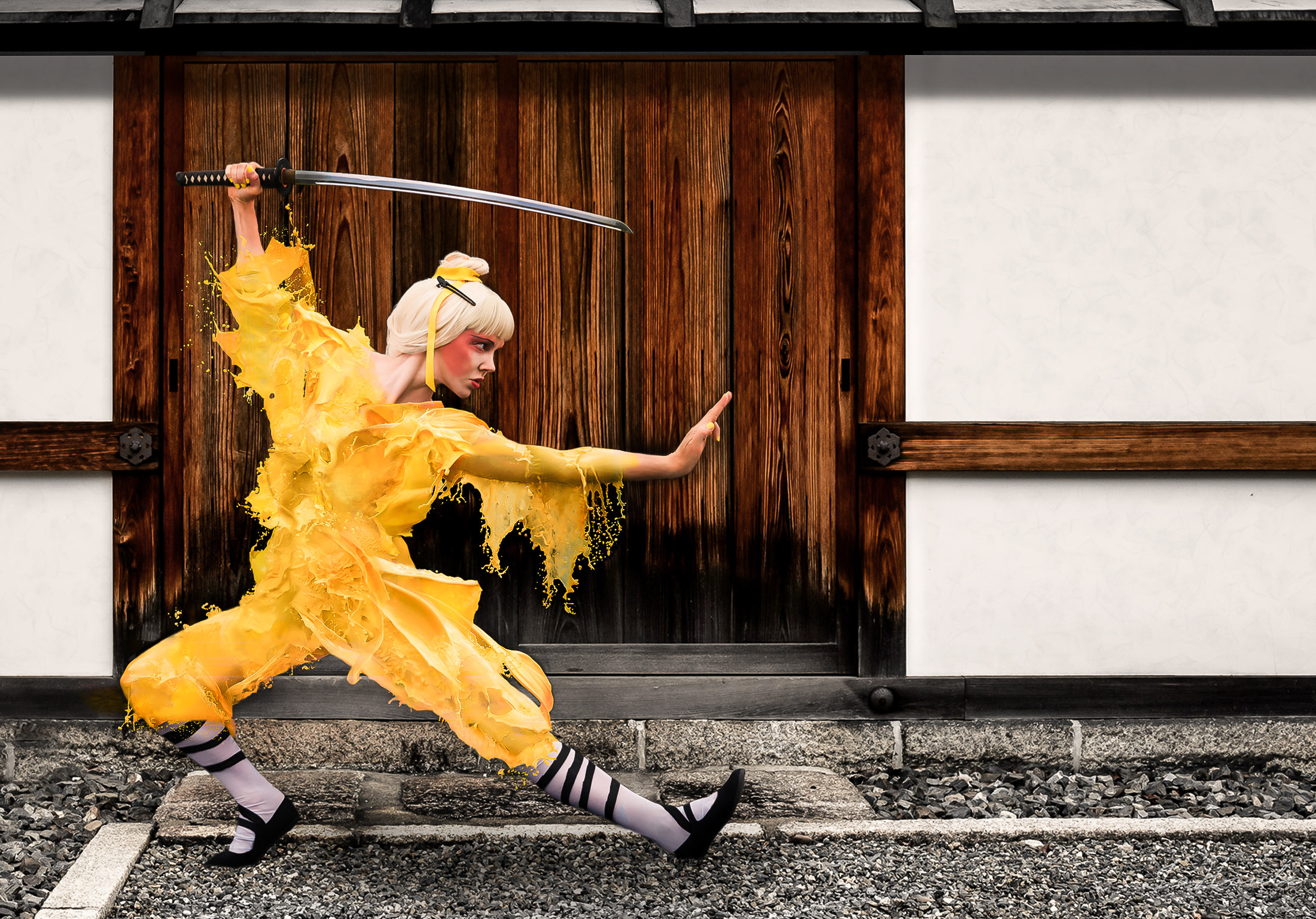
Nikon D800 + Nikkor 24-70mm f/2.8 @ 48mm — 1/3200 sec, f/5, ISO 800 —
image data
Milk Ninja
composition copyright by Josée Houle
shared here with permission
This composition, by Montreal photographer Josée Houle, combines my
photo of a wall at Kyoto's Myouhouin Temple (妙法院), which I published on a post in 2012, with photos of a model being splashed
with colored milk.
Josée described the process to me:
First, the model took the pose with all the pieces of the outfit that wasn’t liquid, to create the basis of the final photo.
Once the perfect shot was taken, every accessory was taken off and then, the process of splashing milk on the model could
start.
While the model taking and keeping the same pose as in the final photo, two assistants started splashing and pouring yellow
coloured milk on each one part of her body at the time, repeating this process again and again, until many usable shots of the
milk splashing were taken.
After, on the computer, a selection of the best shots of milk was done and then combined, one layer over the other, on the
final photography, to create the entire kimono on the model.
A background was added to create a context and the whole picture was blended together to give the most realistic yet fantastic
result possible.
It sounds really messy, but fun, and the result is certainly interesting and fun.
She posted the photo, along with information about it, on Facebook, and also some behind-the-scenes photos
here.
July 30, 2018
Cycling Mt. Fuji

map — nearby photos
My Best View of Mt. Fuji All Day
its slope runs up into the clouds in the upper right
As I wrote in my previous post, I recently
hiked on Mt. Fuji. Today's post is about the next day's bike ride, a 100+ mile odyssey that included two
cycling climbs up Mt. Fuji as far as the paved roads would allow, a typhoon, and a
dead iPhone. The dead iPhone explains why there are few photos on this post.
Here's the ride at Strava:
There are no roads to Mt. Fuji's peak at 3,776m (12,389'), of course, but three roads go fairly high up. My
initial goal of the day was to ride one of them, the same road I'd taken on the way to start the previous day's hike: the
“Subaru Line”. It's a toll road that ends at
the “5th Station”, at about 2,300m of elevation (7,550'). Many people
start their Mt. Fuji hikes from where it ends.
I was a bit apprehensive about the long climb, but also looking forward to it because the forecast
was for rain all day, due to the typhoon that has passed the previous day; I enjoy riding in the rain
when it's warm and I'm properly prepared for it. In this case, “properly prepared” means that
I don't mind getting soaked and I don't have anything that'll be hurt by getting wet.

map — nearby photos
View from the Hotel
Kawaguchiko Hotel (河口湖ホテル)
I started out at 8am with an hour-long spin around the lake the hotel sat on. It started to rain a bit during that 18km (11mi)
loop, but I still got the “best” view of Mt. Fuji that I'd have all day:

map — nearby photos
Mt Fuji
should be there in the upper right

map — nearby photos
Inexplicable Path
Having made the loop around the lake and returned to the road in front of the hotel, I turned toward
Fuji. Within a few minutes I was on the road that heads up to the fifth
station, rising quite consistently at a mild-but-relenetless 5% for its entire 30km (19mi) length.
Half an hour in, I got to the toll booth and paid my 200 yen (US$1.80) and chatted with the tolltaker a
bit. He said that there were something like five cyclists the previous day. I
was probably the only cyclist this day, because, I would later find out, two hours later, just as
I was arriving at the top, the road was closed due to high winds.
And those winds, along with rain, started in earnest soon after I passed the toll gate. They didn't bother me much early on, as
I just concentrated on passing the roadside markers placed every 100m, counting down the distance to the end of the road 23km away
(Strava segment).
I also counted the busses that passed. Extrapolating from the number that passed during one five-kilometer
stretch, I estimate that about 120 busses passed me on the climb.
The road on the way up is wide and sweeping and pristine — just lovely — and so when a
bus or car wants to pass, it usually just swings out into the oncoming lane to do so. There's usually not that much
traffic, but at one point a couple of buses had to wait before they could pass me, and it happened to be
at the one short span on the entire climb where the steepness backed off a bit. So, to have some fun and
to not make them wait so much, I sped up considerably. Soon the opposing traffic cleared and they
passed, but because I was moving along at a good clip they just slowly creeped
by me. The bus was full, and smiling faces in the window passed by slowly. It was
fun.
And just as I was giving a nod to someone at the window next to me, I saw 50m ahead two deer leap
across the road. I'm glad that the buses had had to slow down for me earlier, or the deer might be
venison.
As I got closer to the top, the wind and rain got very strong, and for the last 3km or so I had such
a strong tailwind that I was going 40kph uphill, where later on the return
trip, despite now going downhill, I could barely manage half that speed because it was into the
wind.
At the very top, the road ended and the gravel hiking trail I'd taken the previous day started:

map — nearby photos
End of the Road
Mt. Fuji (富士山)
This video doesn't show it well, but the wind was ridiculous:
It was the strongest wind I'd ever tried to ride in, but as it later turned out, that record would stand for only a few hours.
I stopped for 45 minutes at a cafe for coffee and food, then ventured out into the cold, powerful winds for the
trip down. (The temperature at the top was 10°C / 50°F)
On the way up, it takes considerable effort to ride, so that kept me warm despite the wind and rain and cold. I wouldn't have
that on the way down, so I wore a raincoat, mostly as a windbreaker. I'd not thought to bring
full-finger gloves, so I got two small plastic bags from the cafe and put them over my brake levers, and
just used the brakes while my hands were inside. It worked great to keep the wind off, which is all
I needed.
And that wind was strong at first. I kept one foot unclipped just in case a gust blew me over, and twice within the
first few minutes I came to a complete stop because the side-guts were so
scary. After a few kilometers of this stop-and-go, I got below some line and
the strength of the gusts receded considerably. After that it was a lovely descent. I took it
slowly because of the rain and wind, so it took 35 minutes (Strava segment), but on a
nice day it'd have been a lovely descent to hit hard. The current
best-recorded time is a 62kph-average 22:46.
After exiting the toll booth, there's a 3km almost-completely-straight downhill section of road cut through the forest. It
was still rainy and somewhat gusty, but I give it a good go, passing
three buses (the only vehicles I saw the entire way down), earning a #14 spot on the leaderboard.
I still felt good, so I thought I'd swing south to another of the three roads that head up Mt. Fuji. I
hadn't researched it well, but I'd made a route for my Garmin so that I
could get there. The start of the climb was about 20km away, mostly uphill as it turned out, but
the last 6km was a lovely fast (if it weren't raining) descent.
I didn't know it at the time, but the climb I was about to embark on, more than 11km at more than 10%, would end up being the most mentally-difficult
climb I'd ever done. The unrelenting steepness for the entirety of its long length made it was far worse
than the only climb I've ever given up on, the much shorter but much steeper climb in Osaka mentioned here
It begins near some kind of military base, as evidenced by the tanks that I
saw moving around as I turned onto the road for the climb. The first
3km of road is ramrod straight, 10% grade, wide beautifully-paved road through forest, apparently flanked by more unseen military
base, because at one point I almost jumped out of my skin when what I can only
imagine was high-caliber machine gun fire erupted not far away in the woods to the side.
Also early in the climb, my power-meter pedals started to give really crazy readings. And then, while having stopped to take
a photo of something with my iPhone, the screen suddenly spazzed out in a
very “the hardware just went bad” kind of way. I immediately powered it off. I didn't know it at the time, but it would never power
on again, and Apple ended up replacing it. I lost all the photos from the day, save those I had messagedt to others or posted on Facebook.
The odd timing of these two problems actually had me wonder for a moment whether this was the result of some kind
of military jamming. 
July 13, 2018
Climbing Mt. Fuji at Night
Nikon D4 + Nikkor 24-70mm f/2.8 @ 24mm — 1/50 sec, f/4.5, ISO 220 —
map & image data — nearby photos
Wow, What a View
just after sunrise, just prior to a typhoon blowing in
at 3,205m (10,500') elevation, on Japan's Mt. Fuji
I moved to Japan in 1989, and the person who met me at the airport in Tokyo was Krish Kulkarni, a graduate student at Tokyo
University, and the twin brother of Ram Kulkarni, my best friend at my own graduate school in America. I had most recently
met both of them a year ago in Tokyo, and last week met Krish and
his family as they vacationed in Japan.
Climbing Mt. Fuji was high on the list for Krish's 19-year-old son Vishnu, and they kindly invited me along.
Nikon D4 + Nikkor 24-70mm f/2.8 @ 24mm — 1/2500 sec, f/5.6, ISO 12800 —
map & image data — nearby photos
Our Hotel
Kawaguchiko Hotel (河口湖ホテル)
Nikon D4 + Nikkor 24-70mm f/2.8 @ 44mm — 1/2500 sec, f/6.3, ISO 720 —
map & image data — nearby photos
View From The Back Window
Krish's back was bothering him, and despite a massage in Kyoto from Ken-chan that helped a lot, he decided to sit this climb out, knowing that I'd
be there to look after his family. Anyway, Krish had already climbed Fuji twice in his life, which is more than enough.
There are various trails up Fuji, but the only one open this early in the season was the “Yoshida Trail”. One reaches it by
road to the “5th Station” at about 2,300m (7,500'), then hikes the remaining 1,476m (4,800') of vertical climb.
Our plan was to climb at night, so as to see the sunrise from the top.
We didn't make it.
Nikon D4 + Nikkor 24-70mm f/2.8 @ 70mm — 1/800 sec, f/2.8, ISO 12800 —
map & image data — nearby photos
Our Last View of the Mountain
at least, our last non-close-up view,
on the drive up toward the “5th Station”
Nikon D4 + Nikkor 24-70mm f/2.8 @ 24mm — 1/50 sec, f/4.5, ISO 1100 —
map & image data — nearby photos
Scenic View
on the drive up
Nikon D4 + Nikkor 24-70mm f/2.8 @ 24mm — 0.6 sec, f/4.5, ISO 12800 —
map & image data — nearby photos
At the Parking Lot
Mt. Fuji Yoshida 5th Station
In the past I've had very good (skill) with slow-shutter hand-held shots, such as
this,
this, and
this, but my luck (skill) wasn't here on this hike; the shot above,
and other slow-shutter hand-held shots are all pretty bad, sorry.
At about 8pm, the three of us (Krish's wife Nilu, son Vishnu, and me) headed out from the parking lot.
Nikon D4 + Nikkor 24-70mm f/2.8 @ 24mm — 1/6 sec, f/2.8, ISO 12800 —
map & image data — nearby photos
Starting the Hike Proper
with Nilu Kulkarni and Vishnu Kulkarni
Nikon D4 + Nikkor 24-70mm f/2.8 @ 24mm — 1/50 sec, f/2.8, ISO 6400 —
map & image data — nearby photos
Half an Hour In
at the “6th Station”
photo by Vishnu Kulkarni
Nikon D4 + Nikkor 24-70mm f/2.8 @ 24mm — 1/4 sec, f/2.8, ISO 12800 —
map & image data — nearby photos
What We Saw
for most of the night.... nothing more than a string of lights
At various places along the trail are huts that seem to be privately-owned businesses that offer lodging,
and food/drink. They have bright lights, so you can see those dotting the path going up, as well as the
lights of the climbers slowly moving like fireflies in between.
Early on we didn't meet many others on the trail, except a few descending from having seen the sunset,
and the occasional few fast-paced hikers that passed us. I was astounded at how many people completely
ignored my hearty “good evening” as we passed on this relatively unsteep early section. It's possible that
a few had earphone in and didn't hear me, but for the most part I think some people are just jerks. 
Jeffrey E.F. Friedl's Blog

- Jeffrey E.F. Friedl's profile
- 14 followers

