Nikko Lee's Blog, page 28
September 20, 2011
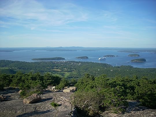
Precipice Trail
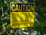
 Remember that caution sign I posted a few weeks ago? The hiking club daredthe dangerous of the Precipice trail two weeks ago.
[image error]
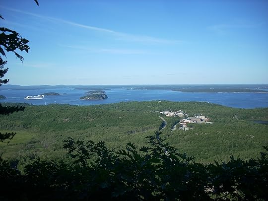
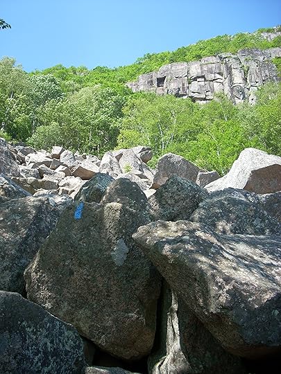
In only half a mile, the trail climbs from the park loop road to the top of Champlain (1058 feet).
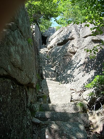
This is probably the most notorious half mile stretch in the park. Not only is it steep, but numerous ladders, iron rungs, and exposed ledges make Precipice one of the scariest hikes for the casual hiker.
I did this trail on my own last year and found it terrifying. After a summer of learning how to rock climb, I was curious to see if my perception would be different this time. I was the only one in the group I went with this time who had ever gone up Precipice.

There is no shortage of spectacular views on this trail.
Before I knew it we had reached the top of the trail. I was actually disappointed it wasn't longer. If exposed ledges and rock scrambles don't scare you, this is a great trail for a quick but challenging hike.


August 30, 2011
White Water Rafting on the Kennebec River
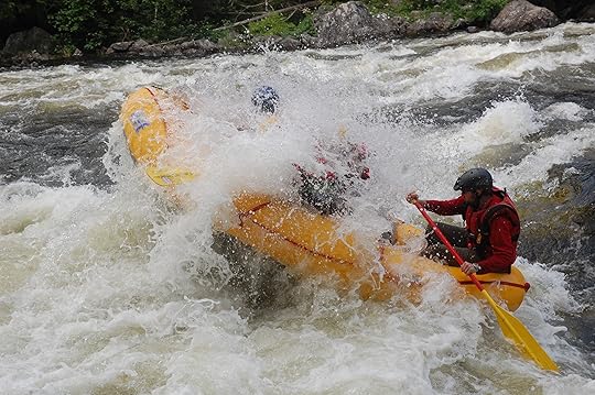
This summer I've got to do a lot of cool things for the first time. I've been to the White Mountains on an overnight hiking trip. I've started to boulder. I've even been learning to climb rocks. Last weekend, I went white water rafting for the first time with the Moxie Gore Paddling club on the Kennebec river.[image error]
We headed up to the club camp Friday night and tented under a clear sky filled with stars. The next morning after a lot of paper work and some safety lessons on how to pull people back into the raft and how to throw the rescue rope, we headed out to a dam north of The Forks.
At first I was a little concerned when I first saw the Harris dam. We were at the top of the dam and the river stretched out some 50 to 75 feet below us. My crazy imagination had us boarding the raft and sliding down to the river. Fortunately, there were stairs and a ramp to walk the raft all the way down to the water's edge.
Into the raft and we were off before we knew it. The first section, our guide explained, is called the sampler. Think of it as a rafting warm-up. Leaning into the waves and rowing on command, we navigated the Rock Garden, Three Sisters, Big Mama, Alleyway, Cathedral Eddy, Z-turn, Magic falls, Dead stream, and Carrying Brook (where we pulled aside and climb a series of steep stairs to grab out lunch packs) rapids without a capsize or losing a rafter. Considering we were in the small boat with only four people, that's saying something. One rapid nearly did send us end over end.
Part way down the river and passed the more adventurous rapids we stopped for lunch at Black Brook. The brook is a popular lunch stop filled with people jumping off of cliffs into the brook pools. Keep an eye out for poison ivy. I think I found the patch that got me there.
After lunch we headed down the second half of the river towards The Forks. Aside from a few tricky spots where our guide was navigating us sideways or trying to get us stuck in a pocket, the rest of the ride was a leisurely float. We did manage to dump one person, but our guide had her back in the raft within seconds.
 There are a few spots where rafters voluntarily leave their rafts to safely float/swim in the gentler rapids of the lower section. I was perfectly content to stay relatively dry and warm.
Rafting was a lot of fun and having a guide who knew exactly where to paddle and when to hold on was amazing.
On the way back to camp we stopped by Moxie Falls (a 90 feet plunge). It was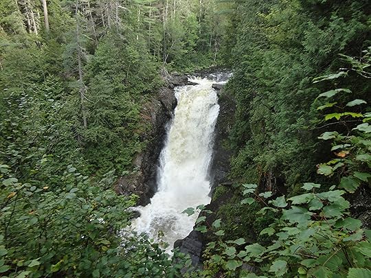 spectacular and overflowing with water released from Moxie Lake in advance of Irene's arrival. It's about a mile walk from the road along a smooth dirt path. Well worth the detour.
By evening, we packed in the tent and headed to the bunk house. Morning brought rain and winds and we were on our way back to the coast with another activity to add to the list of summer adventures.
August 25, 2011
Kurt Diedrich's Climb
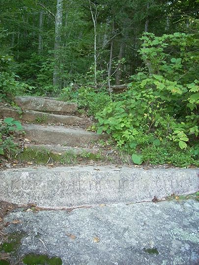 Recently, the hiking club made another trip up Dorr Mountain. This time we headed up Kurt Diedrich's Climb. While not as steep as the Ladder trail, Diedrich's Climb rises 450 feet in the matter of 0.4 miles. We started from the Abbe Museum parking lot, by the Acadia Wild Gardens. If you haven't visited the gardens, you really should. They offer miniature ecosystems from bogs and marshes to mountain top scrub.
A short 0.3 mile walk took us from the parking lot to the trail head at the north end of the tarn. If you end up walking towards the museum itself, you will have to do some light bushwhacking to get to the actual trail just to your left.
From the trail head, we climbed and climbed, stopping as often to admire the view as to partake in the blueberries. The trail side was covered in overburdened blueberries that were the perfect snack for our cookie-less hike.
Diedrich's Climb meets up with the Ladder Trail before completing another 1.0 mile to the top of Dorr. It's not exactly the summit. So we traveled the 0.1 miles to the official summit marker. Another mountain top crossed off the list.
Our route down followed the North Ridge trail (0.8 mile) to the Hemlock trail (0.5 miles) before returning us to the parking lot.
Total distance 3.2 miles in about 2 hours. It's a good alternative to the thigh-burning Ladder trail that is still a challenge.
August 12, 2011
Life is Short, Make it Sweet
During my morning browsing of the CNN website, I came across the article A peanut butter pie in memory of Mikey by Kat Kinsman about Jennifer Perillo's recent blog post. I do not know Mikey Perillo or follow Jennifer's foodie blog (In Jennie's Kitchen). However, I was struck by Jennifer's dedication of one last peanut butter pie (Mikey's favorite dessert) to her recently deceased husband as she and her family adjust to his absence.
It's all too easy to get caught up our busy life. Time goes by too quickly. It is almost inevitable that we put off those little time consuming acts of recognition as we struggle to meet demands at work, home, and the various cycles of our lives. I know I often think to myself 'I should call my parents more often' or 'it's been ages since I talked to this friend.'
The relationships that shape who we are and give meaning to our lives often go under-appreciated. That is until for one reason or another they come to a end.
I know peanut butter pie isn't the pinnacle of healthy eating. But sometimes a little sweetness shared between loved ones is needed. If it makes you feel better, make a salad. The important thing is to share it with someone you love and appreciate the time you have with them.
So these little pies are for all my friends and family near and far who I don't often enough say how much they mean to me. Virtual peanut butter pies for everyone! Leave a comment if you'd like one

These were made using a modified Philsburry recipe (graham cracker shells instead of pastry shells).
August 8, 2011
Weird is wonderful
Late last winter, I gave myself the challenge of writing a zombie erotica. Just for the hell of it. After some great suggestions from the ERWA (Erotica Readers and Writers Association) crit group, I had a decent story and no idea where I would even try to sell it. Then the call came out for the Big Book of Bizarro.

Months later, I now have my very own complimentary copy. I am psyched. I'm not abundantly familiar with the genre other than in the Superman universe. The description of the anthology as "Salacious - Sacrilegious - Scatalogical - Scotomizing - Strange!" is intriguing to say the least. Funny enough my story didn't even make the erotica section. So I am even more curious about the stories that did. I'm in the horror section.
Wait a second, that would make this my first horror short story sale. That in itself is enough to lighten my steps for a few days. Horror was my first love. From Edgar Allen Poe to Clive Barker and Stephen King, I've enjoyed that delicious mixture of fear and vitality that comes from brushes with death and creatures beyond its reache.
Now if someone would only pic up Dark Heritage.
August 4, 2011
Hiking in the White Mountains: Jefferson, Adams, and Madison
Last weekend I capped off a week of vacation by taking a hiking/camping trip to the White Mountains with the hiking club. I already knew this was going to be a challenge. It was after all my first hiking trip to last more than a day, and I've never hiked in the White Mountains before.
We started our drive to NH midday on Friday. The plan was to arrive at the Great Gulf Wilderness parking lot off route 16 around 6PM. Considering how many times I've traveled down route 2 towards Vermont on my way to Canada, my car could have been on auto-pilot. It's actually quite a nice drive, if not a bit long (about 4 hours).
[image error]From the Great Gult parking lot, a paved path leads into the woods. The itinerary was to hike about 4 miles along the Great Gulf trail and camp overnight near the cut off trail for the Six Husbands trail. It started misting shortly after we left the parking lot. We decided to set out camp about 2 miles in before it got too dark. Of course it rained all night and everything was soaked in the morning. Fortunately, I was in a well-sealed tent and spent a dry night.
[image error]
The next morning we tackled the Six Husbands Trail with the idea of summiting mounts Jefferson, Adams, and Madison with a return trip down the Osgood trail to the Osgood tenting site for a total of 8.2 miles with the highest elevation reached on Mount Jefferson (5712 feet). Then we would hike a leisurely 2 miles back to the car. That was the plan. The adventure was a little different.
The Six Husband's trail starts off as a moderate hiking trail that steepens and quickly becomes more about climbing up ladders and rocks rather than walking. In the space 1.9 miles, the trail rises from 3500 feet to the summit of Jefferson. That's a gain of about 2200 feet in 2 miles. The ladder portions were actually really reasonable, if not a little unnerving. The real challenge was the slab at the top of the last ladder. With only about three feet clearance and five feet in width, the slab slants towards a steep dropoff into thin air. Unnerving? You could say that. Lugging around packs with camping gear only made it that much more interesting. We ended up having to rope off the packs and pull them across the slab to make the scramble a little easier.
[image error]
The trail seemed to go on upwards forever. Every time I thought we were approaching the top, another false peak awaited us. Eventually we cleared the Six Husbands trail only to find boulder fields rising up to the top of Jefferon. It took nearly 5 hours to cover about 4 miles and those 2200 feet in elevation. Boy was I beat, and I wasn't the only one.
[image error]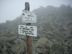 As part of our group headed down the Jefferson Notch trail, the rest of us journeyed on. Two hours later, after by-passing the summit of Mount Adams, we came upon the Madison Hut. There is no more welcome sight to weary hikers than a building with toilets, potable water, and food. Bring some cash with you if you go, and you can enjoy a meal at 0.4 miles shy of the summit of Mount Madison. They also have cots for overnight stays.
[image error]
It's amazing what a hot drink and some food will do for the exhausted hiker (me). After a brief stop at Madison hut, we headed towards Mount Madison by way of Star Lake with a brief visit to the Moon rock (a huge granite stone).
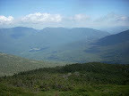
Unfortunately, I was pretty tired at this point and didn't take many pictures. But trust, it was amazing. The mistiness that protected us from the sun finally gave way by late afternoon. The boulder hopping along the Parapet trail was challenging. Towards the the Osgood Trail the wind really whipped up. Finally, I got a beautiful view of the valley below.
[image error]
By the time we reached the Osgood tent site, I ached. There was still some light left, and we decided to press on to the cars. Unfortunately, two moose grazing along the trail had other ideas. This was actually my first moose spotting. A cow and a bull, and they even made some calls. Needless to say, we gave them plenty of room and waited until they moved far enough off the trail for us to sneak around very quietly.
Night came quickly after that and we decided to set up camp for the night. Considering this was my first camping/hiking trip, I was happy I made it as far as I did. The second night of camping was under a clear sky with stars that twinkled between the leaves overhead.
In the morning, after following some misleading cross-country ski maps, we covered the last mile or two back to the car.
The first stop in Gorham was a little motel dinner at the corner of route 2 and 16. It was the perfect place for hungry hikers. I practically inhaled my eggs benedict and even a few pieces of French toast for good measure.
Total mileage was 14.8 miles with around 4000 feet elevation gain overall. One nifty online calculator estimated the caloric requirement for this hike at 2000 calories. I believe it. For nearly three days, I felt like eating everything in site.
A good hike. A tough hike. I'd definitely do it again. For more pictures see this album.
July 26, 2011
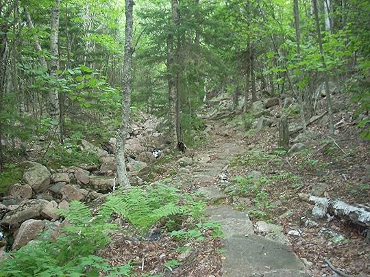
Ladder Trail up Dorr Mountain
I am on vacation this week, which means I'm slower than usual to post. I've had a few busy days of hiking and bouldering followed by entertaining visiting family. My great ambitions of going hiking every morning have been waylaided by a need to sleep. Maybe I should keep well-rested since the upcoming three day hiking/camping trip in the White Mountains.
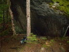
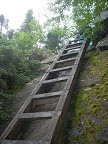
Last Wednesday, the hiking club tackled the Ladder trail up Dorr Mountain, down the A Murray Young path, and back to the cars along the Gorge (Cannon Brook tarn trail). Total of 3.5 miles in about 3 hours. The more abitious (and faster) of our group returned via Cadillac mountain (total of 4.8 miles in about 3 hours).
 First, the Ladder trail only has 3 ladders. It really should be called the stair trail (too many to count). The first half mile is just about straight up with a few plateaus to rest burning legs. Nothing is terribly exposed, so it isn't bad for people with moderate fears of heights. It is horrible for people with a fear of stairs.
About half way up there is a choke point through a split boulder. It was tight enough that I had to take off my pack to squeeze through. Beyond the Ladder trail, the views of Bar Harbor and Frenchman's Bay are breath taking. It is also my favorite place to get a good picture of the lab.
Once at the top of the trail, we stopped for our customary cookie break. It was well-deserved after all those stairs. Our sweat and exhaustion was quickly blown away by a gusty wind that urged us on.
[image error]After our group split (apparently one peak is just not enough for some people), most of us headed down the A Murray Young path. It's essentially a rocky valley that runs the length between Dorr and Cadillac mountains. Although it was bone dry, I could imagine the rushing spring run-off. The path eventually flattens out into a gentle path.
Part of the Gorge trail is under heavy construction and a little bit of an ankle twister. However, it is generally flat and an easy walk passed beaver ponds and tarns.
With a little hard work and good timing, I should be able to get some bouldering and climbing pictures up. This weekend's SAR training involved rappelling to rescue a stuck climber. It was a good reminder of what it's like to go over the edge.
July 17, 2011
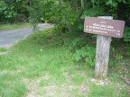
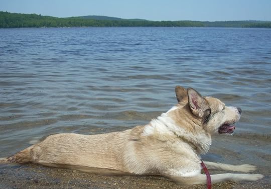
Black Mountain Trail (Donnell pond)
[image error]It turned out to be another busy hiking weekend. This morning Bruno (my dog) and I headed off to Black Mountain in the Donell Pond public reserved land to hike with a couple of friends and their dogs. Bruno had cruciate ligament surgery in January and is still easily tired. However, he was so excited about getting out with other dogs that I think he largely forgot about that until half way through the hike.
The Black Mountain Cliffs trail took us on about a 2.9 mile loop (with a side detour, of course, towards the Western summit) and took about 3 hours.
We started at the parking lot that is also the trail head for the Shoodic mountain trail and Schoodic beach. The climb up Black mountain (1094 feet) is not particularly difficult but there were enough rock ledges and trees to climb over that Bruno was panting hard by the time we reached the top. And we were all drinking lots of water.
Atop of Black mountain, the forest is carpeted by moss. 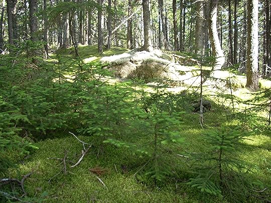 It has that enchanted forest feel that is only moderately detracted by the persistent buzzing of deer flies. Needless to say we didn't stop longer than it was necessary to give the dogs some water and rest Bruno's leg.
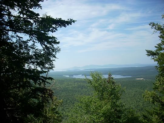
Open views are hard to come by. However, as we began the descent down to Schoodic beach, we came upon several cliffs that looked out onto Donnell pond and beyond. The way down to the beach was moderately steep but largely obstacle free. Of course my dog had to check out every dry stream bed in the hopes of finding some water to cool off in. Once we reached the beach I had one happy and wet dog. Got to love summers in Maine.
Black Mountain Cliffs Loop
July 16, 2011
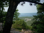
Orange and Black Trail and Champlain Mountain
Talk about a dire, but warranted, warning. Today's hike started from the lab and headed up the park loop road. We walked all the way over to the Precipice trail head. However, we only remained on the Precipice trail as long as it took to get to the junction with the Orange and Black trail (formerly East trail). The plan was to take Orange and Black north then the Champlain north ridge (Bear brook trail) to reach the summit (1,058 feet) before returning via the Beachcroft trail by Huguenot head. The mileage was somewhere around 3-4 miles and took about 2.5 hours to complete.
[image error]
The climb up the beginning of Precipice was steep, but that only meant the ocean views were quickly achieved. We went up. We went down. We went over boulders. And under them.
 Lots of rock and lots of climbing. It was so much fun, but by no means an easy hike. While the Precipice trail veered off to go straight up Champlain, the Orange and Black continues up and down towards the north until another junction takes you back to the park loop road or up to the north ridge of Champlain.
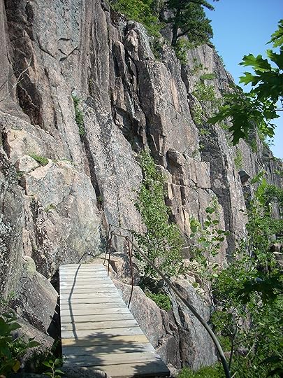
After the ups and downs of Orange and Black, the rest of the way up Champlain was a piece of cake. Still about a 45 degree angle, completely exposed to the hot July sun. However, it was flat.
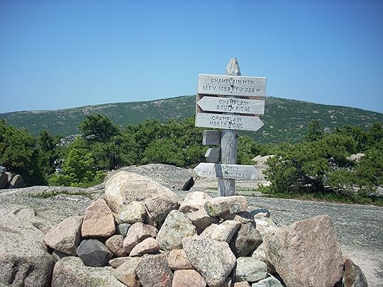 At the top, we were greeted by scores of ambitious young people who had braved the Precipice trail to reach the top. That hike will have to wait until late August, at least for me. Rested, fed, and watered, it was with great joy that we headed down Beachcroft.
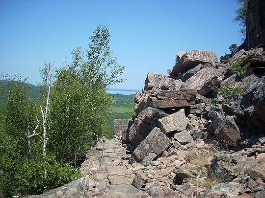
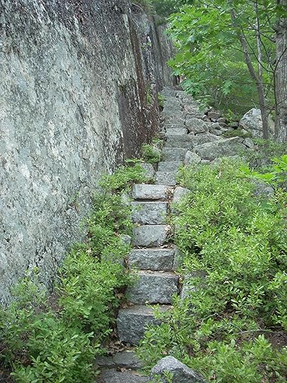
The stone work in Acadia National Park is wonderful. I'm constantly amazed at the trails. Beyond Huguenot head, the trail becomes a switch back of sloping cobble stones and steps. All too soon we were back to route 3 and heading towards to lab.
huguenot
July 11, 2011
9.2 miles and 4 peaks
This seems to have been a busy week for me. I actually did this hike on Sunday but am only now getting around to writing it up.
The hike last Sunday was an ambitious one, at least for me. I'm positive it's the most hiking that I've done all summer. It was a good warm-up for an upcoming overnight hiking trip to the White Mountains.
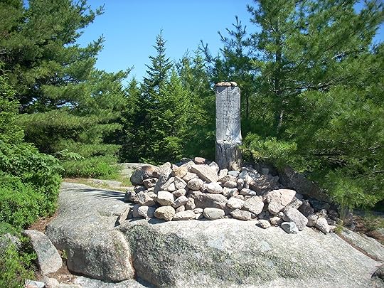
We started out at the parking lot along route 3 at the start of the the trail leading to the Day mountain carriage road and trail. We planned to hit three summits: Day (583 feet), Triad (696 feet), and Pemetic (1,248 feet). Sitting on top of Pemetic, we couldn't resist adding Penobscot (1,194 feet) to our route. It took nearly 5 hours to complete the trek of 9.2 miles.
[image error]
There is actually a carriage road that leads to the top od Day mountain that is an ease walk or bike ride. The trail head is a little deceptive since there is a well trodden path on the right of the carriage road. A little beyond this dead end is the Day mountain trail head on the left of the carriage road. It wasn't too long before we were rewarded with our first spectacular view.
 Under the nearly-cloudless blue sky it was easy to press on to the summit. This is a fairly easy trail that left us with lots of energy to hike down the slope towards Triad mountain.
[image error]
Triad is actually three peaks. We headed towards the highest peak up some steep and rocky slopes via the Pemetic southeast trail. The climb was quick, but required a few stops to catch my breath. At the top, we stopped to enjoy the view and rest our legs.
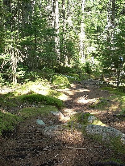 Between Triad and Pemetic there is a forest path that could come straight out of a fairytale. The sun streaking through the leafy canopy lit the moss covered forest floor. I even spotted a large toad stool. Distracted by the magic beauty of the forest, I actually had to jog a little to catch up with the group. Sometimes you just need to stop and take a deep breath of the pine-laced air.
The climb up to Pemetic was even more abrupt than up Triad. There were plenty of rocky stairs and ledges to scramble over before breaking from the forest and climbing the rest of the way up the sun-drenched rock face to the summit.

Our lunch break well-earned, we enjoyed our food looking out onto Jordan Pond and the surrounding peaks. It was just too tempting to stop there. Plus we were contemplating a trail up Penobscot that I hadn't traveled yet. I'm a sucker for a new trail.
So down Pemetic and across to Jordan pond we headed. An easy walk around the northern end of the pond and we were heading up the Deer Brook Trail. It was a fairly steady climb, or maybe my legs were getting a little tired. Still I couldn't resist another detour to Sargent Pond, a little oasis between Sargent and Penobscot mountains.
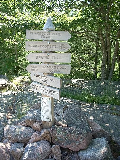
After another snack break, we double backed and sumited Penobscot.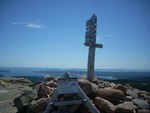 From there is was only a few more miles down to the Spring Trail, onto Jordan pond house, and back to the parking lot south of Day Mountain.
By the end of the 9.2 miles, I was ready to sit down to a cold drink and some hot food. The plan for this weekend is a lot less ambitious, the Orange and Black trail to the top of Champlain. Only 3.4 miles, provided I am not tempted to add another detour. With so many connecting trails and roads, it's just so easy to keep walking.