
Ray Hosler's Blog, page 30
April 16, 2015
Shimano CN6701 chain lasts about 4,000 miles

Shimano 6701 chain lasted about 4,000 miles.
I have assiduously cleaned my chains over the past 15 months and now the results are in. Swapping between two chains, cleaning them about once a month, they lasted about 4,000 miles each.
I use the Park chain-wear indicator tool and dump the chain between the 0.5 and 0.75 measurement. I found that the chain only needs a couple hundred miles to go from 0.5 to 0.75. Another interesting observation is that half the chain indicates more wear than the other half.
I use Simple Green to clean the chains. After removal I put it into a wide-mouth container and shake vigorously, then let sit for a day. I then remove the chain, wash it off with water and sun-dry.
For lubricant I am currently using ProLink ProGold. Before that I used Finish Line Dry. The ProLink seems to hold up a little better over the miles (doesn’t need more lubrication), but it’s not a big difference.
The days of using car oil are over; these fancy Shimano chains require a teflon-like lubricant that can penetrate the narrow gaps.
My Shimano Ultegra freewheel is still working well after three years and five months, about 22,000 miles. As soon as I start having chain skip, I’ll replace it.


Shimano CN6701 chain lasts about 3,900 miles
Shimano 6701 chain lasted about 3,900 miles.
I have assiduously cleaned my chains over the past 15 months and now the results are in. Swapping between two chains, cleaning them about once a month, they lasted about 3,900 miles each.
I use the Park chain-wear indicator tool and dump the chain between the 0.5 and 0.75 measurement. I found that the chain only needs a couple hundred miles to go from 0.5 to 0.75.
I use Simple Green to clean the chains. After removal I put it into a wide-mouth container and shake vigorously, then let sit for a day. I then remove the chain, wash it off with water and sun-dry.
For lubricant I am currently using ProLink ProGold. Before that I used Finish Line Dry. The ProLink seems to hold up a little better over the miles (doesn’t need more lubrication), but it’s not a big difference.
The days of using car oil are over; these fancy Shimano chains require a teflon-like lubricant that can penetrate the narrow gaps.
My Shimano Ultegra freewheel is still working well three years and five months, about 22,000 miles. As soon as I start having chain skip, I’ll replace it.
April 11, 2015
Bicycle helmet bill – further study needed

Eastern descent of Mt. Hamilton, April 12, 1981. No helmets here (Jobst Brandt photo).
California SB-192, sponsored by 25th District Senator Carol Liu, has been sent back to committee for further study, according to the California Bicycle Coalition.
Liu���s office released a statement, first reported by former Streetsblog San Francisco editor Bryan Goebel, explaining the decision:
“The bill was amended to create a comprehensive study of bicycle helmet use in California and evaluate the potential safety benefits of a mandatory helmet law. Carol believes in consensus-driven policy, and there were too many conflicting opinions about helmet use. A study will provide the data needed to guide us to the next step.”
In a recent interview with Liu on KQED public radio (I listened to it but can’t find the recording), the senator was asked why she sponsored the bill. She replied that two close relatives (nephews) had been in serious bike accidents.


April 9, 2015
Once Upon a Ride: Big Basin Blowout

June 7, 1981, Corn Roast ride through Big Basin State Park. Just before abandoning sew-ups. From left: Roger ?, Jim Westby, Parker McComas, Rick Humphreys, Ray Hosler, Dan Green, Tom Ritchey, Tom Holmes.
May 24, 1981
Riders: Jobst Brandt, Tom Ritchey, Ted Mock, Ray Hosler, Strange John, Rick Humphreys
Route: Up Alpine Road, Skyline to 9, 9 to 236, service road to Big Basin State Park, Gazos Creek Road, Cloverdale Road, Stage Roads, Hwy 1, Purisima Creek Road, Kings Mountain Road
Weather: Warm, partly cloudy, humid
Tire/Mechanical: None
As the Indianapolis car racers revved their engines this Memorial Day weekend, the Jobst Riders rode their machines through the Santa Cruz Mountains, talking about the upcoming Corn Roast in Swanton and the Sierra ride the second weekend in June.
On this Sunday morning Ted Mock showed up. The professional photographer is a veteran bike racer who now just rides with Jobst. In his mid-30s, Ted rents a house with bicycle frame builder Peter Johnson on College Avenue in midtown Palo Alto.
As we rode on Alpine Road we came across a motley crew of Palo Alto Bike Shop riders — Ron Hoffacker, Don McBride, Kathy Williams, Dave Prion and Brian Cooley. Then we passed triathlete Mark Sisson as he changed a flat tire.
At the green gate where the two-mile dirt section of Alpine Road begins, Jobst observed a Hutton’s Vireo feeding its young in a nest. We carried on with the shop riders and talked about all topics under the sun, the chance of rain, etc.
The riders rolled south on Skyline with an incomparable view of fog hugging the nearby mountains, all the while being followed by a telephone company van. Jobst figured the driver was looking for a particular power pole on the roadside.
At the Cal fire station water fountain we tanked up our water bottles, except Jobst, who never carries one. As we swatted horse flies, Jobst recalled an incident in France: “I was riding along when I felt this sting under my neck, so I took a swat and thought I had rid myself of the pest. Well, a few minutes later I noticed a stinging sensation again and took another swat at the same spot. This time I felt a big splat and saw blood all over my hand when I drew it away.”
The ride down 9 went at its usual high speed. Rick turned off at Waterman Gap to head back for a wedding. This left Jobst, Ted, Ray and Tom. On the North Escape Road into Big Basin park, Tom noticed a sign, and when they stopped for water at a stream Tom said, “They put that sign there because of what happened to me in Yosemite Park.”
Know park regulations
Tom said that he was cited by a ranger for riding his bicycle on the trails in Yosemite. The park had a rule against riding any mechanized vehicle on trails in the park. The sign Tom referred to said: “You are responsible for knowing park regulations.”
We stopped at the park store and purchased some expensive food while Jobst told the clerk where they were headed. “That sounds like a spine-jarring experience,” she replied. As we sat eating we talked about Peter’s sleeping habits, the amazing ability of John Howard to recall names, distinguishing marks over the eyes of Steller’s Jays and the disappearance of Strange John.
We decided to head up Gazos Creek Road, one of Jobst’s favorite rides through the redwoods. We rode by several deer next to the road, which didn’t move a muscle as we passed within inches. “They know where they are!” Jobst said.
After about five miles of moderate ups and downs on the dirt road we reached a junction and the Sandy Point Guard Station, or what was left of it. It had burned down in the 1960s.
We headed steeply down Gazos Creek Road and passed a large wooden sign declaring this land to be a tree farm.
Jobst pointed out that someone had tried to chop down the sign with an ax. That brought back memories of the Dog Town sign in Marin County off Hwy 1, which got chopped down time and again by sign collectors.
We dropped down Gazos Creek Road, which was in great shape with the exception of small muddy spots from recent rains. Two cycle tourists loaded down with bags slowly descended as we blew by.
As we rode on the flat section of Gazos Creek Road following the creek, Jobst and Tom got into a heated argument about religion, which was par for the course.
Along Cloverdale Road (dirt at the time) a car came speeding by at 60 mph, kicking up a cloud of dust. Jobst turned around to watch and see if it could make a difficult corner. He didn’t see it and declared, “It could be in a ditch now for all we know.”
As we rode past the Butano State Park entrance, Jobst remembered a bike race held here, which went through the hills to our right over fire roads.
Tom headed home on Pescadero Road while the rest of us turned left to Pescadero. Jobst pointed out the town’s new flag pole, about 40 feet tall with a huge American flag waving in the ocean breeze. The old wooden pole blew down in a storm.
Pescadero festival
In Pescadero we were greeted by Holy Ghost Festival signs. We stopped at a new store and Jobst greeted the owner. who he knew by name. Outside we listened to Jobst doing his usual harangue on all sorts of topics: lousy car suspensions, bad tires on a VW Bug, an overweight cyclist, and so on.
We continued north on Stage Road to Hwy 1, where we turned right and continued to Purisima Creek Road. During the gentle climb to the dirt section Jobst identified many different birds and pointed out San Mateo County’s first oil well hugging the hillside above the creek.
The sun peeked through the fog along the coast while we enjoyed the lush green canyon cut by Purisima Creek over the eons. An old logging road would take us to Skyline Boulevard, with some sections as steep at 18 percent. [The Midpeninsula Regional Open Space District purchased the surrounding land around this time.]
Guns in Purisima Creek
Heading up the lower reaches of the dirt road before the wooden bridge, we came upon a group of four hikers, one of them carrying a dog with a broken leg.
Later on we passed two hikers dressed in military fatigues, one of them toting an AR15 (civilian version of the M16). Jobst asked, “What are you going to do with that?” The gun-toting hiker replied, “We’re going to shoot targets.”
At the bridge we stopped to enjoy the creek and Jobst commented what a pity it is that trout no longer live in Purisima Creek.
After the difficult climb, we headed down Kings Mountain Road, Jobst and Ted passing a speeding Mercedes convertible on the way.
Jobst drinks from Purisima Creek at the upper bridge. Photo taken day of this ride. It’s overgrown here today.


April 7, 2015
Filoli Estate visit brings back cycling memories
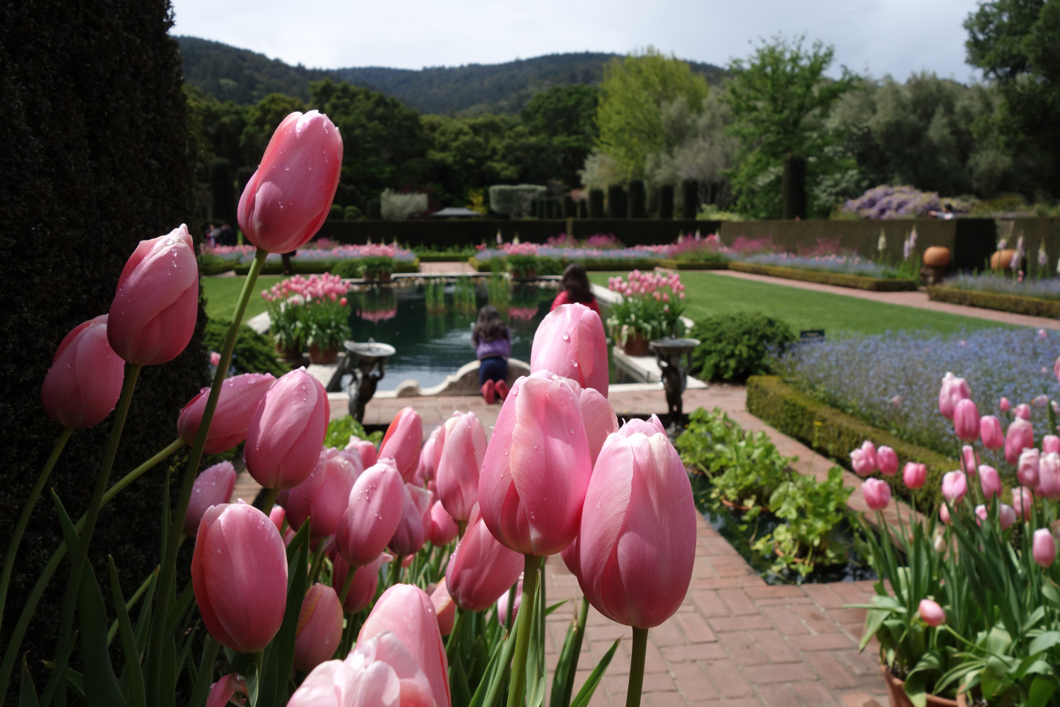
Filoli gardens, one of the few local places where you’ll see imported tulips in blossom.
Today I visited the Filoli Estate off Cañada Road on a day heaven-sent for touring the surrounding gardens — partly cloudy with intermittent showers.
It brought back distant memories of bike rides on Old Cañada Road, which goes for about four to five miles when adding Runnymede Road, Crystal Springs Trail, then Old Cañada Road to Hwy 92. I think parts of the road are still paved, but otherwise it’s a fine dirt road, well maintained by the San Francisco Water Department.
Of course it’s illegal to ride on and has been probably since the 1930s when the area was closed to the public. That’s a crying shame because it’s some of the most beautiful countryside in the Coast Range.
Not even William Bowers Bourn, who built Filoli in 1915, could catch a break when it came to the public watershed. The Bourns wanted to have an estate built along Crystal Springs Lake, on land owned by the Spring Valley Water Company. Even though Bourn was the president of the company, a law forbade private ownership of the public domain property that supplied water to the city of San Francisco.
We can credit Bourn for the modern Cañada Road alignment. He asked that the road be moved to its current location when he built his estate.
I mention this now because this would be a natural extension of the Fifield-Cahill Trail north of Hwy 92. In fact, the roads were one in the same back in the 1930s. You can see them on either side of Hwy 92 at the old rock quarry.
It’s an obvious multi-use trail since it’s wide and there are many local equestrians, cyclists and joggers who would love to use it with minimal restrictions. Maybe one of these days…
Old Canada Road (shown in red) would make a great multi-use trail. (Google map image)


April 4, 2015
People need the “Freedom to Roam”

Gate 12 at China Grade in 2015. We get the message.

Gate 12 in 1981. Out having fun. How times have changed. (Jobst Brandt photo)
In my travels around the world, I’ve noticed that nowhere else is the concept of “private property” so zealously defended by landowners than the US of A.
I attribute some of that, especially in the Western U.S., to the persistent Old West mentality where a man defends his homestead from real threats with his trusty gun.
Times have changed and I wish our laws would change to keep up with the times.
In Europe the “Freedom to Roam” operates in many jurisdictions when it comes to allowing people to use others’ lands. As long as you’re just passing through, say on foot or on bike, not hunting, fishing or in any way defacing the land, public access is granted.
Civilized Europe has been around for millennia, which I believe is the reason for this enlightened approach. Likewise, some areas in Asia follow the same “Freedom to Roam” principle. For example, on Malaysia’s millions of acres of rubber tree farms, mountain bikes are allowed in many sections.
In the Western U.S., native Americans did nothing but roam, but this way of life came to a screeching halt with the arrival of settlers from back East and the introduction of barbed wire in the 1870s.
In the Santa Cruz Mountains, the Freedom to Roam principle could be applied in many locations, especially private logging roads. I’ve ridden these private roads, and others, for decades and never had any issues. It’s a different story today. Back in the early 1980s we didn’t have many mountain bikes, so seeing a bike was an oddity.
Lumber companies will claim liability issues, but the “Freedom to Roam” takes that into account. The land user accepts liability, not the landowner.
Public parks and agencies need to be more proactive about gaining easements on these roads, which often border their parks.
I’m not optimistic such an enlightened approach will happen in my lifetime, but it will happen, eventually.


April 3, 2015
Cyclists rattle the fence for opening the San Francisco Watershed

Charlie Krenz, Los Trancos Water Board member and active mountain biker supports opening the SF watershed.
Imagine hundreds of people rattling that chain-link fence surrounding the San Francisco Watershed, demanding that we stop treating it like Area 51.
That was the impression I left with after attending a San Francisco Board of Supervisors meeting on Thursday, which discussed opening the Public Utilities Commission’s San Francisco watershed, a measure sponsored by supervisors John Avalos and Scott Wiener.
More than a dozen speakers, mostly cyclists, lined up to weigh in on the issue, thankfully keeping comments to two minutes or less. The supervisors had a full schedule with many important matters to attend to.
The naysayers came from the Sierra Club, Committee for Green Foothills and California Native Plant Society. The plant society doesn’t want to see non-native invasive species introduced to the watershed (although they’re already there), while the Sierra Club flat out believes humankind is the invasive species. There might be some agreement on that point from Native Americans.
A host of bureaucrats representing the public agencies tasked with managing the watershed laid out the issues and opportunities for granting increased access. Currently there’s a docent-led bicycle ride offered three days a week starting from the south end of the 23,000-acre watershed on Hwy 92. The complaint heard time again is that it’s inconvenient, especially for people living at the north end of the watershed, which would be all of San Francisco.
Steven Ritchie, SF PUC Assistant General Manager of the Water Enterprise, and Tim Ramirez, SF PUC Manager, Natural Resources Division, went into detail on a potential next step — allowing public access with only the requirement of online registration. It could happen within a year, as long as the other agencies involved buy into the plan, including the Golden Gate National Recreation Area (GGNRA), San Mateo County, and probably a half-dozen other agencies I’m not aware of.
What’s involved, exactly, took us down a rabbit hole of bureaucratic red tape, while Supervisor Avalos attempted to pin down a date for an opening while being careful to understand what measures would be necessary to mitigate potential environmental issues and protection for native species. The watershed has done its own environmental impact report, but it was not clear how that would play out with other agencies.
The area under discussion is mostly the north-south Fifield-Cahill Ridge Trail that bisects the watershed. Avalos urged the PUC to work with other agencies to create an east-west trail to link up with open space areas on the Pacific Coast.
The PUC made it clear during its presentation that their first priority is to ensure water quality, which we can all agree is paramount. Let’s just hope there’s water to manage in the years ahead.
As I pointed out, Marin Municipal Water District allows public access and I haven’t heard about any water issues there. East Bay Municipal Utility District allows access on some of its land with paid permits ($10 for a year) and it’s one of the more conservative agencies. The Bureau of Land Management – Clear Creek area in San Benito County – also instituted an online permit to use its land. Bicycle access is free.
In his closing remarks Wiener said he believes there needs to be a balance protecting the watershed and allowing public access, while noting that an informed public with access to these areas can go a long way toward helping with the protection part.
Kudos to the San Francisco Board of Supervisors. They handle their meetings efficiently and give everyone a chance to be heard. Avalos and Wiener have excellent credentials. I think the agencies and supervisors will do the right thing, no matter what the outcome.
For more about the watershed visit the Facebook site, “Open the SF Watershed.”


March 28, 2015
Santa Cruz ride puts a spring in my day

Isn’t it time to take down these signs? Seen on Cloverdale Road and Alpine Road.
There’s nothing better than a spring ride down the coast to Santa Cruz because in all likelihood you’ll have a nice tailwind. Thursday was no exception.
I don’t recall ever riding this loop on a weekday. It’s almost always on Sunday or Saturday. Now that it’s over, I can tell you Sunday is probably the best day for riding.
On Thursday I saw enough Santa Cruz Mountain commuters to last me a while. Because they drive roads like Page Mill daily, they’re aggressive and fast. They don’t anticipate seeing cyclists.
On Moody Road I missed being run over by inches. A Chevy Volt came up from behind while a Tesla came down the hill and I immediately knew that, according to the Law of Confluence, we would all meet at the same place in the road.
I was so far to the right that my front wheel ran off the pavement into the gravel. Just another close call in the life of a cyclist.
But I digress. Things got more civilized on west Alpine Road where I saw only a car or two.
At the Portola State Park Road junction I saw a sign warning cyclists not to ride on Alpine Road due to gravel.
San Mateo County road maintenance might want to include cars in their warning. Loose gravel can be equally hazardous for cars, especially ones in a hurry like those daily commuters.
The sign has been there for many months and the loose gravel is long since gone.
Loma Mar Store under repair? Lots of memories here.
As I passed the Loma Mar store, a place full of memories of past Jobst Rides, I noticed it was jacked up. Repairs? Moving? We’ll see.
I got my tailwind on Hwy 1 and enjoyed the ride into Santa Cruz. I took the usual route through the city via the San Lorenzo River path, over the bridge to Felker Street, Plymouth, Fernside, Emeline Avenue, El Rancho Drive.
Riding up Mountain Charlie Road I noticed about the same amount of traffic I would see on a Sunday afternoon. Nothing to speak of. Even a few cyclists rode by.
Nice bike bridge over San Lorenzo River. There’s also a path under Hwy 1 to Hwy 9.


March 25, 2015
New life for old Avocet Gelflex saddle

Avocet Gelflex saddle gets a new life with a marine vinyl cover.
One of the best bike saddles ever made, the Avocet Gelflex, had one drawback: its flimsy nylon cover didn’t last long.
Today it’s difficult to find a plain nylon saddle cover to go over the Gelflex, so I checked around and found instructions for using marine vinyl to recover a saddle.
The Instructables website “how to” article took me through step by step. It’s a great description, even if I did botch the job.
I’ll share my experience here and give some hard-learned advice.
First, I purchased the marine vinyl at a local fabric shop. It comes in a set width, which was wide enough for a saddle cover, so all you need to do is buy as much as you need in terms of length. I bought a half-yard in anticipation of doing several saddles. The salesperson knew exactly what I was talking about when I mentioned the vinyl. It’s not expensive.
Second, I used a 3M spray glue called Scotch Super 77. It’s an all-purpose adhesive, but maybe isn’t the best spray glue for the job. On reflection I would use a spray that’s meant for “headliner” jobs.
Headliner is a car’s ceiling fabric. Glues made for headliners hold up well in heat and adhere better to the kind of fabrics we’re talking about here.
Third, follow the directions to the letter. I only sprayed one coat on the second spray session, where the sides are glued down the saddle, when two were called for. The result was that the adhesion wasn’t good where your inner thigh touches the saddle.
Fourth, try to make the template as close as possible to the actual size you need. That was a problem with the Gelflex because the saddle cover was almost completely worn away. I had to eyeball it and use the saddle to get an estimate.
However, you don’t want to cut the cover too small, because there is no recovery from such a mistake.
Fifth, the stapling is difficult. I used a hand stapler that usually only works half the time. Sometimes the staple pierced the saddle, other times it didn’t go far enough. I used a different adhesive to glue down the small sections beneath the saddle.
Finally, I had difficulty pulling the vinyl tight so there were no ridges or bumps around the sides. Commercial saddle makers use machines for this step, so don’t expect your saddle will ever come out looking that good.
I’ll give it another try with my second Gelflex saddle and hope for better results. The one I have is functional, but it’s hard to say how long it will last.


March 23, 2015
Squeaky wheels of democracy turning at the Santa Clara Bicycle and Pedestrian Advisory Committee

Bike and pedestrian committee information is found on the Santa Clara website.
I’ve attended a couple meetings of the Santa Clara Bicycle and Pedestrian Advisory Committee and witnessed the democratic process in action. Meetings are open to the public.
What I like about democracy is that everyone has a voice , even if you’re a tiny minority, which is true for bicycle commuters, who make up only about 2 percent of the population.
As I sat through the meetings, I remembered why I left the committee as a member back in the early 1990s. Government moves at its own pace.
I’m not complaining. It’s just the way things are. There needs to be consensus and that takes time.
Back in the early 1990s the grand plan in Santa Clara was to build a recreation path along San Tomas Aquino Creek. I’m happy to say that reach 3 to Monroe Street opened in 2009. That’s about a 20-year wait.
There’s more coming as the path inches its way south on San Tomas Expressway, ending at Stevens Creek Boulevard. It’s a huge improvement for pedestrians who live near the expressway and useful for cyclists who don’t want to ride on the expressway.
I’m not seeing any grand plans on par with San Tomas, but there’s only so much you can do in a city filled with cars.
Now here’s the rub. We all can agree on one thing: traffic gets worse every year and something needs to be done about it. Assuming we continue to see growth — that’s always the plan — something has to give.
Try finding a parking spot at Valley Fair on the weekend, any weekend. Apple is building a massive office in Cupertino right next to Santa Clara. I’m seeing office complexes mushrooming everywhere in Santa Clara, mostly north of Central Expressway.
Bicycle organizations are trying their best to work with local governments to develop a network of bicycle-friendly streets. They call it a “road diet” or “traffic calming” but the bottom line is that it means restricting the flow of traffic, typically from two lanes one direction to one lane and the addition of bike lanes with restricted parking.
Gary Richards, Mr. Roadshow, wrote about the trend in the San Jose Mercury News in 2011, about the time Santa Clara re-striped Pruneridge Avenue for a short distance either side of Lawrence Expressway.
Councilmember Teresa O’Neill, who chairs the committee (and who actually commuted to work by bike), said the Pruneridge re-striping brought a wave of complaints to the city.
I’ve driven that section of Pruneridge numerous times at rush hour and I’m not seeing any change in traffic patterns. If anything, the Lawrence/Pruneridge intersection is less chaotic.
I think the city should take all of Pruneridge from four lanes to two because it’s really just a continuation of Hedding Street in San Jose, and Hedding was changed from four lanes to two in 2013. It’s a great start to having a bike-friendly boulevard across Santa Clara Valley. The obvious continuation would be Homestead Road.
In addition, put every road next to a school on a road diet where bicycle traffic is heaviest.
I’m not under any illusions about the bicycle and its popularity as a transportation option. It will never be as popular as other transportation methods because it requires physical skills and some level of fitness.
However, when it comes to finding ways to reduce traffic, accommodating bicycles by creating a network of bike-friendly streets will increase the number of people who choose to bike commute.
That’s good for the environment and good for transportation in the Valley. With fewer people driving, the road diet won’t be such a bad idea after all.
I’ll share more about what’s happening with the committee down the road. Basically, this is where the cyclist’s agenda meets political reality, but at least our voice is being heard.


Ray Hosler's Blog

- Ray Hosler's profile
- 3 followers

